|
|
|
0 members (),
1,204
guests, and
25
robots. |
|
Key:
Admin,
Global Mod,
Mod
|
|
S |
M |
T |
W |
T |
F |
S |
|
1
|
2
|
3
|
4
|
5
|
6
|
7
|
|
8
|
9
|
10
|
11
|
12
|
13
|
14
|
|
15
|
16
|
17
|
18
|
19
|
20
|
21
|
|
22
|
23
|
24
|
25
|
26
|
27
|
28
|
|
29
|
30
|
|
|
|
|
|
|
There are no members with birthdays on this day. |
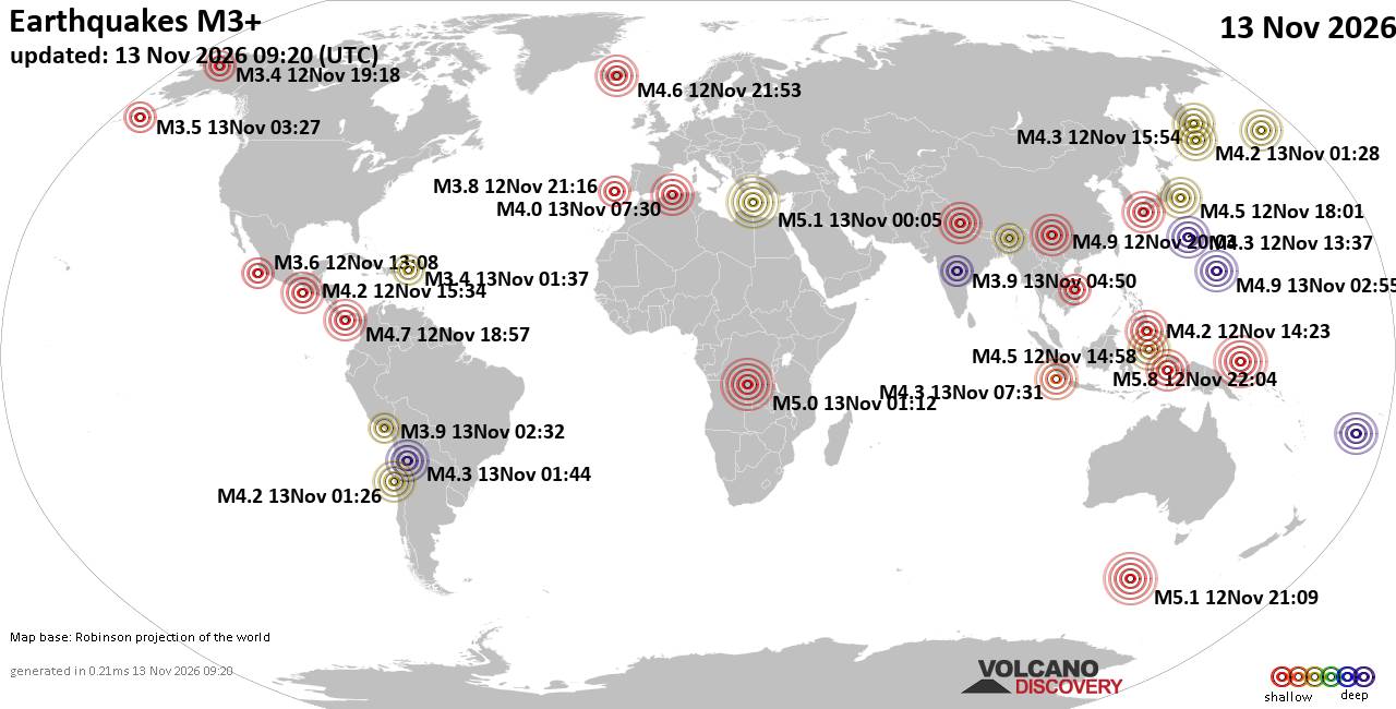
World Earthquake Report for Friday, 13 November 2026
• M 0.5 - 3 km ESE of Pacifica, CA
• M 1.4 - 10 km ESE of Suisun City, CA
• M 1.7 - 6 km NW of The Geysers, CA
• M 2.9 - 133 km SSE of False Pass, Alaska
• M 1.8 - 5 km SE of San Ardo, CA
|

#906248
Sun 11 Oct 2026 05:50:PM
|
Joined: Feb 2001
Posts: 800,656
Launch Director
|
|
Launch Director
Joined: Feb 2001
Posts: 800,656 |
Volcano earthquake report for Sunday, 11 October 2026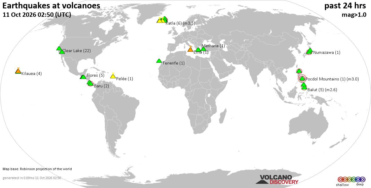 World map showing volcanoes with shallow (less than 50 km) earthquakes within 20 km radius during the past 24 hours on 11 Oct 2026 Number in brackets indicate nr of quakes. Quakes detected near: Agua (9 quakes between mag 0.9-2.0), Askja (10 quakes between mag 0.0-2.1), Balut (2 quakes between mag 2.1-2.6), Baru (2 quakes between mag 2.2-2.2), Barva (2 quakes between mag 2.1-2.3), Clear Lake (24 quakes between mag 0.2-1.8)
Coso (2 quakes between mag 0.9-1.7), Eldey (1 quake mag 1.1), Etna (2 quakes between mag 1.4-1.7), Flores (2 quakes between mag 1.1-1.4), Hekla (3 quakes between mag 0.1-1.2), Hrómundartindur (7 quakes between mag 0.0-2.4), Kalatungan (1 quake mag 1.4), Kilauea (3 quakes between mag 1.7-1.9), Krísuvík (3 quakes between mag 0.5-1.2), Leonard Range (1 quake mag 1.4), Lipari (1 quake mag 1.8), Ljósufjöll (7 quakes between mag 0.2-1.4), Loihi (1 quake mag 1.8), Maroa (1 quake mag 1.2), Maunaloa (2 quakes between mag 1.7-2.2), Moyuta (1 quake mag 1.2), Norikura (1 quake mag 2.7), Pelée (3 quakes between mag 0.3-1.1), Prestahnukur (5 quakes between mag 0.9-2.3), Ruapehu (1 quake mag 1.0), Sarik-Gajah (2 quakes between mag 3.0-3.9), Sousaki (1 quake mag 1.1), Svartsengi (2 quakes between mag 1.0-1.3), Tenerife (1 quake mag 1.1), Turrialba (3 quakes between mag 1.7-2.2) (updated 17h50)\n\nNote: Earthquakes within 20 km from and at depths less than 50 km under active volcanoes are reported. The list is not complete because many volcanoes are not monitored and/or seismic data in high resolution is not available publicly.\n
Volcanoes with recent earthquakes above magnitude 2 or more than 10 quakes are listed below:
Askja volcano (Iceland): 10 earthquakes up to magnitude 2.110 earthquakes occurred near (under) the volcano during 10 hours, the last being recorded quake 6 hours ago. Hypocenter depths ranged between 7.90 and 2.50 km. Earthquake details: (only 5 largest) 2.1 quake 1.7 km ENE of Suðurbotnar Oct 11, 2026 01:39 am (Universal Time) (5 km E) 1.1 quake Iceland: 1.5 km WSW of Herðubreiðartögl Oct 11, 2026 07:47 am (Reykjavik time) (17 km ENE) 1.0 quake Iceland: 1.4 km WSW of Herðubreiðartögl Oct 11, 2026 11:44 am (Reykjavik time) (17 km ENE) 1.0 quake Iceland: 1.8 km WSW of Herðubreiðartögl Oct 11, 2026 07:42 am (Reykjavik time) (17 km ENE) 0.6 quake 1.6 km ENE of Suðurbotnar Oct 11, 2026 07:16 am (Universal Time) (4 km E) All earthquakes at AskjaAskja is a central Icelandic volcano whose major 1875 eruption created the caldera now filled by Öskjuvatn lake. Its last known eruption occurred in 1961. Balut volcano (Mindanao): 2 earthquakes up to magnitude 2.62 earthquakes occurred near (under) the volcano during 9 hours, the last being recorded quake 13 hours ago. Hypocenter depths ranged between 29.00 and 24.00 km. Earthquake details: 2.6 quake Celebes Sea, 29 km west of Sarangani, Davao Occidental, Davao, Philippines, Oct 11, 2026 04:28 am (GMT +8) (19 km WSW) 2.1 quake Celebes Sea, 27 km west of Sarangani Island, Philippines, Oct 11, 2026 01:02 pm (GMT +8) (15 km WSW) All earthquakes at BalutBalut is an 840 m island stratovolcano south of Mindanao whose last known eruption occurred between about 2 million and 11,700 years ago. Hot springs and thermally altered ground occur on its western and southwestern flanks. Baru volcano (Panama): 2 earthquakes up to magnitude 2.22 earthquakes occurred near (under) the volcano during 3 hours, the last being recorded quake 8 hours ago. Hypocenter depths ranged between 24.00 and 6.00 km. Earthquake details: 2.2 quake 38 km northwest of David, Provincia de Chiriqui, Panama, Oct 11, 2026 03:21 am (Costa_Rica time) (18 km SW) 2.2 quake 37 km north of David, Provincia de Chiriqui, Panama, Oct 11, 2026 12:29 am (Costa_Rica time) (11 km ESE) All earthquakes at BaruBarva volcano (Costa Rica): 2 earthquakes up to magnitude 2.32 earthquakes occurred near (under) the volcano during 12 minutes, the last being recorded quake 2 hours ago. Hypocenter depths ranged between 17.00 and 10.00 km. Earthquake details: 2.3 quake Provincia de Heredia, 19 km north of San Jose, Provincia de San Jose, Costa Rica, Oct 11, 2026 09:28 am (GMT -6) (5 km SE) 2.1 quake Provincia de Heredia, 25 km north of San Jose, Provincia de San Jose, Costa Rica, Oct 11, 2026 09:40 am (Costa_Rica time) (4 km NE) All earthquakes at BarvaBarva is a multi-peaked Costa Rican volcano near San José, also recorded as Barba and Las Tres Marías. Its only confirmed eruption dates to around 6050 BCE, while later historical reports are uncertain. Clear Lake volcano (California): 24 earthquakes up to magnitude 1.8Possible earthquake swarm: 24 earthquakes occurred near (under) the volcano during 21 hours, the last being recorded quake 1 hour 17 minutes ago. Hypocenter depths ranged between 11.65 and 0.11 km. Earthquake details: (only 5 largest) 1.8 quake 12 mi southwest of Clearlake, Lake County, California, United States, Oct 10, 2026 09:23 pm (GMT -7) (17 km S) 1.7 quake Sonoma County, 14 mi southwest of Clearlake, Lake County, California, United States, Oct 11, 2026 07:06 am (GMT -7) (16 km SSW) 1.5 quake 27 mi north of Santa Rosa, Sonoma County, California, United States, Oct 11, 2026 07:14 am (GMT -7) (16 km SSW) 1.4 quake 28 mi north of Santa Rosa, Sonoma County, California, United States, Oct 11, 2026 09:32 am (GMT -7) (15 km SSW) 1.1 quake 29 mi north of Santa Rosa, Sonoma County, California, United States, Oct 11, 2026 06:04 am (GMT -7) (15 km SSW) All earthquakes at Clear LakeHrómundartindur volcano (Iceland): 7 earthquakes up to magnitude 2.47 earthquakes occurred near (under) the volcano during 13 hours, the last being recorded quake 3 hours ago. Hypocenter depths ranged between 7.50 and 3.60 km. Earthquake details: (only 5 largest) 2.4 quake 2.8 km WSW of Skeggi_á_Hengli Oct 11, 2026 02:09 am (Universal Time) (3 km W) 1.3 quake 3.1 km NW of Hrómundartindi Oct 11, 2026 01:59 am (Universal Time) (4 km ENE) 1.1 quake 2.3 km SW of Skeggi_á_Hengli Oct 11, 2026 02:08 am (Universal Time) (1 km SW) 0.7 quake 2.8 km WNW of Hrómundartindi Oct 11, 2026 01:55 am (Universal Time) (4 km ENE) 0.5 quake Iceland: 2.2 km WNW of Þrengsli Oct 11, 2026 03:03 pm (Reykjavik time) (11 km SW) All earthquakes at HrómundartindurHrómundartindur is a small volcanic system in southwestern Iceland with an active geothermal area at Ölkeduháls. Its last eruption is uncertain, but activity is thought to have occurred about 10,000 years ago. Maunaloa volcano (Hawai'i (Big Island)): 2 earthquakes up to magnitude 2.22 earthquakes occurred near (under) the volcano during 16 hours, the last being recorded quake 7 hours ago. Hypocenter depths ranged between 41.44 and 39.73 km. Earthquake details: 2.2 quake 39 mi southwest of Hilo, Hawaii County, Hawaii, United States, Oct 10, 2026 09:02 am (GMT -10) (5 km SSE) 1.7 quake 39 mi southwest of Hilo, Hawaii County, Hawaii, United States, Oct 11, 2026 12:46 am (GMT -10) (7 km SSE) All earthquakes at MaunaloaMaunaloa is a huge, frequently active shield volcano on Hawaiʻi’s Big Island. Its predominantly lava-producing eruptions include a well-documented episode in November–December 2022. Norikura volcano (Honshu): magnitude 2.7 earthquakeA magnitude 2.7 earthquake occurred at the volcano 17 hours ago. The quake, which might be volcanic in origin, was located at a depth of 7.60 km depth at 12 km distance SSE from the volcano. Earthquake details: 2.7 quake 36 km west of Shiojiri, Nagano, Japan, Oct 11, 2026 10:12 am (GMT +9) (12 km SSE) All earthquakes at NorikuraNorikura is Japan’s third-highest volcano, reaching 3,026 m in the Northern Japan Alps. Three VEI 3 eruptions are recognized from approximately the past 10,000 years, the last around 50 BCE. Prestahnukur volcano (Iceland): 5 earthquakes up to magnitude 2.35 earthquakes occurred near (under) the volcano during 13 hours, the last being recorded quake 4 hours ago. Hypocenter depths ranged between 16.70 and 3.60 km. Earthquake details: 2.3 quake 12.4 km S of Eiríksjökull Oct 11, 2026 10:48 am (Universal Time) (10 km NE) 1.4 quake Iceland: 11.6 km S of Eiríksjökull Oct 11, 2026 01:34 pm (Reykjavik time) (12 km NE) 1.3 quake 11.9 km SSE of Eiríksjökull Oct 11, 2026 10:25 am (Universal Time) (13 km ENE) 1.2 quake 12.3 km S of Eiríksjökull Oct 11, 2026 11:31 am (Universal Time) (12 km ENE) 0.9 quake 11.8 km SSE of Eiríksjökull Oct 11, 2026 12:45 am (Universal Time) (13 km ENE) All earthquakes at PrestahnukurPrestahnúkur is a roughly 90-km-long volcanic system beside the Langjökull icecap in Iceland. Its three known eruptions occurred during the past 10,000 years, the last at approximately 3350 BCE. Sarik-Gajah volcano (Sumatra): 2 earthquakes up to magnitude 3.92 earthquakes occurred near (under) the volcano during 1 hour 43 minutes, the last being recorded quake 6 hours ago. Hypocenter depths ranged between 10.00 and 10.00 km. Earthquake details: 3.9 quake Kabupaten Pasaman, 39 km northwest of Bukittinggi, Indonesia, Oct 11, 2026 05:17 pm (Jakarta time) (9 km S) 3.0 quake Kabupaten Pasaman, 38 km northwest of Bukittinggi, Indonesia, Oct 11, 2026 06:59 pm (GMT +7) (10 km S) All earthquakes at Sarik-GajahSarik-Gajah comprises three cones at two centers in Indonesia’s Sunda Volcanic Arc. Its last known eruption dates to between roughly 2.6 million and 11,700 years ago. Turrialba volcano (Costa Rica): 3 earthquakes up to magnitude 2.23 earthquakes occurred near (under) the volcano during 4 hours, the last being recorded quake 10 hours ago. Hypocenter depths ranged between 11.00 and 1.00 km. Earthquake details: 2.2 quake Provincia de Cartago, 35 km east of San Jose, Provincia de San Jose, Costa Rica, Oct 11, 2026 12:13 am (Costa_Rica time) (8 km S) 2.0 quake Provincia de Limon, 42 km east of San Jose, Provincia de San Jose, Costa Rica, Oct 11, 2026 01:20 am (Costa_Rica time) (6 km ENE) 1.7 quake 12 km northwest of Turrialba, Provincia de Cartago, Costa Rica, Oct 10, 2026 09:34 pm (Costa_Rica time) (4 km SE) All earthquakes at Turrialbahttps://www.volcanodiscovery.com/earthquakes-volcanoes/news/375895/Volcano-earthquake-report-2026-10-11.html
|
|



CMS The Best Conveyancing solicitors conveyancing quotes throughout the UK
For any webhosting enquiries please email webmaster@aus-city.com
|
|
Forums60
Topics925,566
Posts960,363
Members2,960
| |
Most Online102,106
Jul 10th, 2026
|
|
|
|
|

|









































