|
|
|
0 members (),
1,406
guests, and
27
robots. |
|
Key:
Admin,
Global Mod,
Mod
|
|
S |
M |
T |
W |
T |
F |
S |
|
|
|
|
|
1
|
2
|
3
|
|
4
|
5
|
6
|
7
|
8
|
9
|
10
|
|
11
|
12
|
13
|
14
|
15
|
16
|
17
|
|
18
|
19
|
20
|
21
|
22
|
23
|
24
|
|
25
|
26
|
27
|
28
|
29
|
30
|
31
|
|
There are no members with birthdays on this day. |
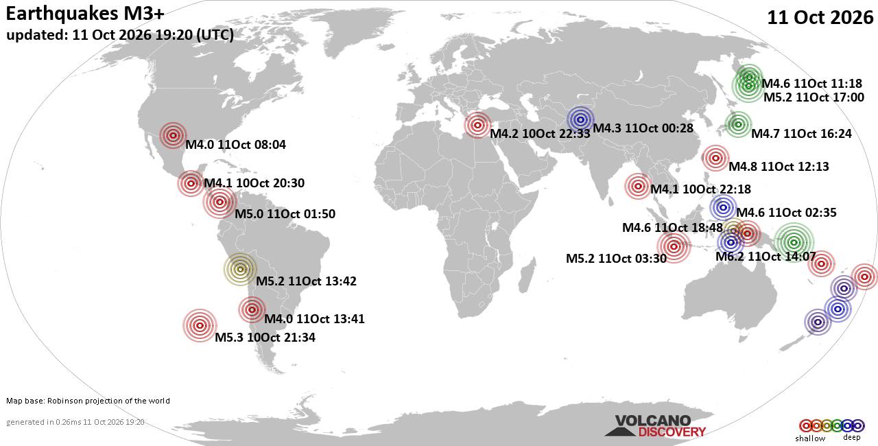
World Earthquake Report for Sunday, 11 October 2026
• M 4.7 - 156 km ESE of Neiafu, Tonga
• M 4.6 - Southwest Indian Ridge
• M 7.7 - 12 km WSW of Pitaloza Arriba, Panama
• M 2.5 - 73 km SSW of Adak, Alaska
• M 5.2 - 18 km SSE of Camaná, Peru
|
|
|
Joined: Feb 2001
Posts: 678,977
Launch Director
|
|
Launch Director
Joined: Feb 2001
Posts: 678,977 |
SPC Oct 11, 2026 1930 UTC Day 3 Severe Thunderstorm OutlookSPC 1930Z Day 3 Outlook 
Day 3 Convective Outlook
NWS Storm Prediction Center Norman OK
0209 PM CDT Sun Oct 11 2026

Valid 131200Z - 141200Z

...THERE IS A SLIGHT RISK OF SEVERE THUNDERSTORMS ACROSS PARTS OF
THE CENTRAL AND SOUTHERN PLAINS...

...SUMMARY...
Widely scattered severe storms appear possible over portions of the
central and southern High Plains Tuesday afternoon into night. More
isolated severe weather may occur into the mid Mississippi Valley,
and in parts of the Lower Great Lakes.

...Central/Southern Plains to Mid-MS Valley...

Enhanced mid/upper southwesterly flow will reside across the region
on Tuesday in advance of an eastward-propagating upper low over the
Great Basin to central Rockies vicinity. At the surface, weak lee
low development is forecast across southeast CO/southwest KS, with
surface troughing extending southward across the southern High
Plains. Meanwhile, a surface front will extend from the High Plains
low east/northeast across northern KS toward northern IL during the
evening. Southerly low-level flow and a strengthening low-level jet
will support mid 60s to near 70 F dewpoints across the warm sector
from portions of western TX into OK/KS and the Mid-MS Valley. While
midlevel lapse rates are not forecast to be particularly strong,
rich boundary layer moisture will foster 1000-2000 J/kg MLCAPE.

Where stronger heating occurs in closer proximity to the surface
trough and triple point from northwest TX into central KS,
supercells will be possible amid vertically veering wind profiles.
Damaging winds and a tornado or two appear possible within this zone
of better instability and shear. Convection is likely to increase
along the breadth of the surface front into the Lower MO/Mid-MS
Valley as warm advection increases during the evening and overnight
hours. This convection may tend to be elevated within isentropic
ascent atop the surface front, further supported by
boundary-parallel wind profiles. Midlevel temperatures are forecast
to be cooler, and MUCAPE could approach 1000-1500 J/kg. Marginal
hail and gusty winds may accompany this activity into the nighttime
hours.

...Lower Great Lakes...

Showers and thunderstorms are likely to be ongoing Tuesday morning
ahead of an approaching midlevel shortwave impulse over the Great
Lakes. Deep-layer westerlies will increase through the day as this
disturbance approaches, resulting in a moderately to strongly
sheared environment. If sufficient heating can occur, surface
dewpoints near 60 F will aid in modest destabilization, resulting in
a conditionally favorable environment for localized strong wind
gusts and perhaps a tornado.

..Leitman.. 10/11/2026
Read morehttps://www.spc.noaa.gov/products/outlook/day3otlk_1930.html
|
|



CMS The Best Conveyancing solicitors conveyancing quotes throughout the UK
For any webhosting enquiries please email webmaster@aus-city.com
|
|
Forums60
Topics869,493
Posts904,289
Members2,960
| |
Most Online102,106
Jul 10th, 2026
|
|
|
|
|

|









































