|
1 members (Webmaster),
1,408
guests, and
24
robots. |
|
Key:
Admin,
Global Mod,
Mod
|
|
S |
M |
T |
W |
T |
F |
S |
|
|
|
|
|
1
|
2
|
3
|
|
4
|
5
|
6
|
7
|
8
|
9
|
10
|
|
11
|
12
|
13
|
14
|
15
|
16
|
17
|
|
18
|
19
|
20
|
21
|
22
|
23
|
24
|
|
25
|
26
|
27
|
28
|
29
|
30
|
31
|
|
There are no members with birthdays on this day. |
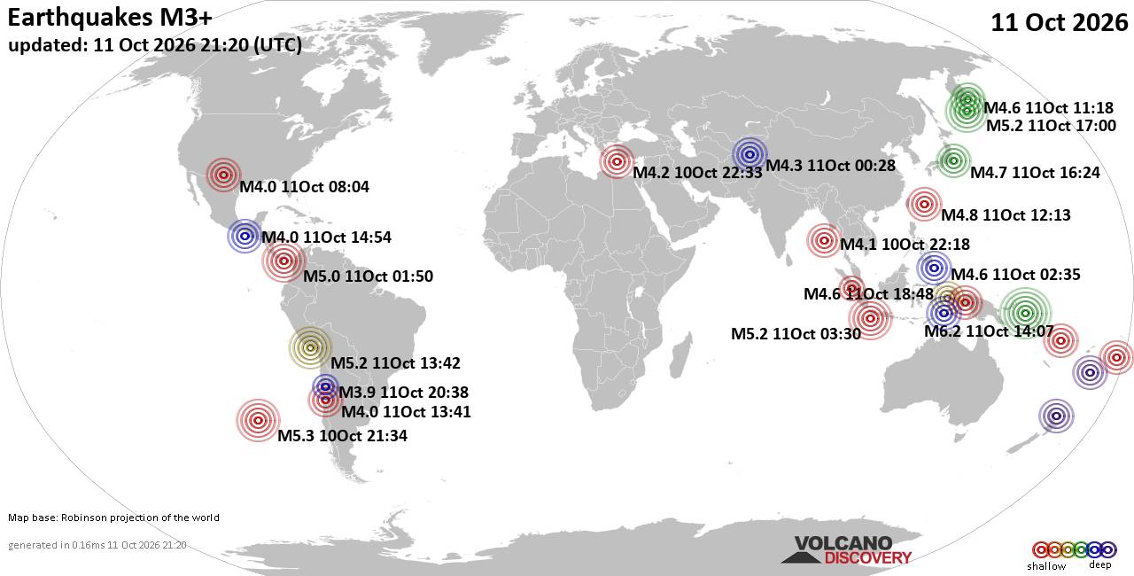
World Earthquake Report for Sunday, 11 October 2026
• M 4.2 - 6 km WNW of Wauna, Washington
• M 2.0 - 93 km NNW of Aleneva, Alaska
• M 4.5 - 59 km NE of Tadine, New Caledonia
• M 2.5 - 33 km WNW of Desert Center, CA
• M 2.5 - 33 km WNW of Desert Center, CA
|
|
|
Joined: Feb 2001
Posts: 678,977
Launch Director
|
|
Launch Director
Joined: Feb 2001
Posts: 678,977 |
Issued at 300 PM CST Sun Oct 11 2026 000
WTPZ45 KNHC 112112 CCA
TCDEP5
Hurricane Simon Discussion Number 18...Corrected
NWS National Hurricane Center Miami FL EP202026
300 PM CST Sun Oct 11 2026
Corrected spelling of Sierra in first sentence.
Simon is still a Category 4 hurricane, but appears to be feeling the
effects of the nearby high terrain of the Sierra Madre Mountains as
the inner core is brushing up against the Mexican coast. The eye
remains observed on geostationary satellite imagery, but is more
cloud filled than earlier with warmer surrounding cloud tops. While
the 18 UTC subjective Dvorak fix was still at T6.5/125 kt, the
objective intensity estimates have continued to fall, with values
now in the 109-115 kt range. Therefore, the initial intensity is
being lowered to 115 kt for this advisory. An earlier Synthetic
Aperture Radar (SAR) RCM-1 pass was very useful to adjust the 34-
50- and 64-kt radii of Simon as the hurricanes wind field continues
to shrink in size.
Simon has stubbornly maintained a north-northwestward motion,
roughly parallel to the coastline, estimated at 335/5 kt. It is now
looking increasingly likely that Simon will avoid making a direct
landfall in the short-term, though its eastern inner core will
likely produce hurricane conditions as the storm continues to move
north-northwestward from Playa Perula to Cabo Corrientes this
afternoon and evening. The steering ridge centered over the Texas
coast is likely to maintain this motion now for the next several
days, though with some slowdown in the motion due to a weaker but
competing ridge located to Simon's southwest. On Tuesday into
Wednesday, a large short-wave trough is forecast to move across the
southwestern United States and this feature should provide enough
southwesterly environmental flow to turn the hurricane to the
northeast, finally reaching the coast of Mexico in 60-72 h. Compared
to this morning, the guidance has shifted westward and slower once
again, and there remain some outlier solutions like the GFS that
want to turn Simon southwestward beyond 48 h. However, the majority
of the ensemble guidance (European-EPS, Google DeepMind) do show
this slow recurving solution back into Mexico. The NHC track
forecast is a little bit west and slower for the first 36-48 h, but
then bends back to the previous forecast track thereafter, still
showing Simon moving inland and dissipating in the day 3-4 period.
This forecast still remains low confidence.
Intensity wise, it is now looking more likely that Simon will not
weaken as much as originally expected, now that it is only brushing
up against the coast instead of part of its inner core moving
inland. Still, the high topography in Jalisco should still have a
negative effect, which has already been seen in Simon's wind field
shrinking in size. The hurricane-regional models still show
significant weakening over the next 12-24 h, even the ones that only
skirt the coast of Mexico, and the NHC intensity forecast still
shows a fast rate of weakening during that time. However, other
environmental conditions remain very favorable, as shear stays under
10 kt, and sea-surface temperatures warm to 31-32 C as Simon passes
north of Cabo Corrientes and enters waters that have been unaffected
by recent tropical cyclones (Polo and Rachel). However, there will
be a significant amount of nearby dry air and it remains to be seen
how intact Simon's inner core will remain over the next 24 h of near
land interaction. The latest NHC intensity forecast now shows Simon
maintaining hurricane intensity, and this forecast could still be
low if the inner core remains more robust than the hurricane
regional models are forecasting. This forecast is now on the higher
end of the intensity guidance aids, but is under the SHIPS guidance
this cycle, and also remains low confidence.
Key Messages:
1. Catastrophic wind and life-threatening storm surge impacts are
likely along a portion of the west-central coast of Mexico, and a
Hurricane Warning is in effect from Punta San Telmo to El Roblito.
Residents should continue to shelter in a safe room to ride out the
storm as the most significant hazards with Simon are now ongoing.
2. Simon is now expected to approach the coast of west Mexico later
this week, where Hurricane conditions are now possible along the
coast of El Roblito to Bahia Tempehuaya. A Hurricane Watch is now in
effect for this region.
3. Heavy rainfall associated with Simon will impact portions of
southwestern and west-central Mexico over the next few days. This
rainfall will produce life-threatening flooding and mudslides,
especially in areas of steep terrain.
4. Swells will affect portions of the southwestern and west-central
coast of Mexico over the next few days. These swells are likely to
cause life-threatening surf and rip current conditions. Please
consult products from your local weather office.
FORECAST POSITIONS AND MAX WINDS
INIT 11/2100Z 19.6N 105.8W 115 KT 130 MPH
12H 12/0600Z 20.2N 106.1W 90 KT 105 MPH
24H 12/1800Z 21.0N 106.6W 80 KT 90 MPH
36H 13/0600Z 21.6N 106.9W 75 KT 85 MPH
48H 13/1800Z 22.2N 107.1W 75 KT 85 MPH
60H 14/0600Z 22.8N 107.0W 75 KT 85 MPH
72H 14/1800Z 23.4N 106.6W 75 KT 85 MPH
96H 15/1800Z 24.0N 105.9W 30 KT 35 MPH...POST-TROP/INLAND
120H 16/1800Z...DISSIPATED
$$
Forecaster Papin Source: Hurricane Simon Forecast Discussion Number 18
|
|



CMS The Best Conveyancing solicitors conveyancing quotes throughout the UK
For any webhosting enquiries please email webmaster@aus-city.com
|
|
Forums60
Topics869,618
Posts904,414
Members2,960
| |
Most Online102,106
Jul 10th, 2026
|
|
|









































