|
0 members (),
1,577
guests, and
27
robots. |
|
Key:
Admin,
Global Mod,
Mod
|
|
S |
M |
T |
W |
T |
F |
S |
|
|
|
|
|
1
|
2
|
3
|
|
4
|
5
|
6
|
7
|
8
|
9
|
10
|
|
11
|
12
|
13
|
14
|
15
|
16
|
17
|
|
18
|
19
|
20
|
21
|
22
|
23
|
24
|
|
25
|
26
|
27
|
28
|
29
|
30
|
31
|
|
There are no members with birthdays on this day. |
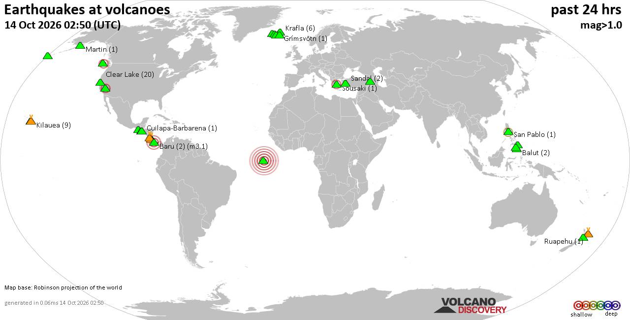
Volcano earthquake report for Wednesday, 14 October 2026
• M 2.9 - 14 km ENE of Glacier View, Alaska
• M 2.9 - 14 km ENE of Glacier View, Alaska
• M 1.8 - 17 km W of Volcano, Hawaii
• M 1.5 - 83 km ESE of McCarthy, Alaska
• Moderate mag. 4.0 earthquake - 67 km southwest of Minatitlán, Estado de Ve...
|

#907040
Mon 12 Oct 2026 08:54:AM
|
Joined: Feb 2001
Posts: 678,977
Launch Director
|
|
Launch Director
Joined: Feb 2001
Posts: 678,977 |
Issued at 200 AM MST Mon Oct 12 2026 000
WTPZ45 KNHC 120854
TCDEP5
Hurricane Simon Discussion Number 20
NWS National Hurricane Center Miami FL EP202026
200 AM MST Mon Oct 12 2026
Simon continues to show signs of weakening as the eye has become
filled in, although infrared imagery shows that the central dense
overcast has cooled since the previous advisory. There is a wide
spread in intensity estimates, ranging from 73-127 kt. Since there
has been an overall modest degradation to the cloud pattern, the
current intensity is nudged downward to 100 kt. The initial wind
radii were modified with the help of timely SAR pass.
The cyclone is drifting off to the northwest as it is being steered
by a distant mid-level ridge centered over the south-central United
States. Simon is expected to continue moving slowly near the coast
of Mexico for the next few days. However, there is still a higher
than normal amount of uncertainty in the track, and some models
show that Simon gets trapped in an area of light steering between
the US ridge and one well southwest of Simon. Later, a trough from
the northwest will approach the hurricane and force Simon to turn
toward the northeast with increasing forward speed, though the
timing of this turn is uncertain. The latest NHC forecast is just
west of the previous advisory after considering some of the latest
AI-based guidance.
Weakening is expected to continue due to Simon's proximity to the
mountainous terrain, as well as some easterly wind shear. However,
the sea-surface temperatures that Simon will be moving across
later this week are around 31-32 C, which could moderate the
weakening trend, as well as the new track being slightly farther
offshore. The current NHC intensity forecast is generally the same
as the previous forecast with only a few adjustments. Simon is
still expected to rapidly weakening once the cyclone makes landfall
around 72 h.
Key Messages:
1. Dangerous wind and storm surge impacts are likely along a
portion of the west-central coast of Mexico, and a Hurricane
Warning is in effect from Playa Perula to El Roblito. Residents
should continue to shelter in a safe room to ride out the
storm as the most significant hazards are ongoing.
2. Simon is expected to approach the coast of western Mexico later
this week, where hurricane conditions are possible. A Hurricane
Watch is in effect from El Roblito to Bahia Tempehuaya.
3. Heavy rainfall associated with Simon will impact portions of
southwestern and west-central Mexico over the next few days. This
rainfall will produce life-threatening flooding and mudslides,
especially in areas of steep terrain.
4. Large swells will affect portions of the southwestern and
west-central coasts of Mexico over the next few days. These swells
are likely to cause life-threatening surf and rip current
conditions. Please consult products from your local weather office.
FORECAST POSITIONS AND MAX WINDS
INIT 12/0900Z 20.0N 106.3W 100 KT 115 MPH
12H 12/1800Z 20.6N 106.7W 90 KT 105 MPH
24H 13/0600Z 21.2N 107.1W 85 KT 100 MPH
36H 13/1800Z 21.8N 107.3W 80 KT 90 MPH
48H 14/0600Z 22.3N 107.2W 80 KT 90 MPH
60H 14/1800Z 22.9N 107.0W 80 KT 90 MPH
72H 15/0600Z 23.4N 106.6W 70 KT 80 MPH...INLAND
96H 16/0600Z 24.1N 105.8W 20 KT 25 MPH...POST-TROP/INLAND
120H 17/0600Z...DISSIPATED
$$
Forecaster Katz/Blake Source: Hurricane Simon Forecast Discussion Number 20
|
|



CMS The Best Conveyancing solicitors conveyancing quotes throughout the UK
For any webhosting enquiries please email webmaster@aus-city.com
|
|
Forums60
Topics874,535
Posts909,331
Members2,960
| |
Most Online102,106
Jul 10th, 2026
|
|
|









































