|
1 members (Alisa),
1,531
guests, and
24
robots. |
|
Key:
Admin,
Global Mod,
Mod
|
|
S |
M |
T |
W |
T |
F |
S |
|
|
|
|
|
1
|
2
|
3
|
|
4
|
5
|
6
|
7
|
8
|
9
|
10
|
|
11
|
12
|
13
|
14
|
15
|
16
|
17
|
|
18
|
19
|
20
|
21
|
22
|
23
|
24
|
|
25
|
26
|
27
|
28
|
29
|
30
|
31
|
|
There are no members with birthdays on this day. |
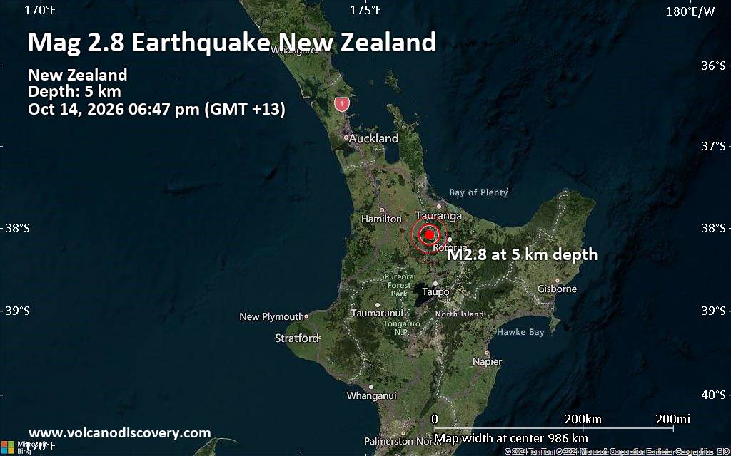
Small magnitude 2.8 quake hits 24 km northwest of Rotorua, New Zealand, in the early evening
• M 1.5 - 30 km W of Nikiski, Alaska
• M 0.5 - 10 km SSE of Idyllwild, CA
• M 1.0 - 13 km SE of Livermore, CA
• M 7.7 - 12 km WSW of Pitaloza Arriba, Panama
• Volcano earthquake report for Wednesday, 14 October 2026
|
|
|
Joined: Feb 2001
Posts: 678,977
Launch Director
|
|
Launch Director
Joined: Feb 2001
Posts: 678,977 |
SPC MD 2371MD 2371 CONCERNING SEVERE THUNDERSTORM WATCH 683... FOR PARTS OF SOUTHWESTERN INTO CENTRAL OKLAHOMA 
Mesoscale Discussion 2371
NWS Storm Prediction Center Norman OK
0847 PM CDT Tue Oct 13 2026

Areas affected...parts of southwestern into central Oklahoma

Concerning...Severe Thunderstorm Watch 683...

Valid 140147Z - 140345Z

The severe weather threat for Severe Thunderstorm Watch 683
continues.

SUMMARY...Strong to severe wind gusts could increase a bit further
for a period this evening, into the 9-11 PM CDT time frame, in
association with an organizing cluster of storms across southwestern
into central Oklahoma.

DISCUSSION...In the presence of favorable deep-layer shear,
convection has grown upscale into at least a modestly organizing
cluster, along the leading edge of a cold pool spreading northeast
of the Texas South Plains/eastern Panhandle into southwestern
Oklahoma.  Recent satellite imagery indicates continued cooling of
cloud tops, and frequent lightning flash rates have been maintaining
intensity. The environment ahead of this activity is slowly cooling
and inhibition for boundary-layer parcels is increasing.  However,
CAPE for potential updraft inflow may still be on the order of 2000
J/kg for another hour or so, before diminishing toward the Greater
Oklahoma City vicinity.

A couple of recent strong to severe wind gusts have been recorded in
Hardeman and Harmon counties of northwest Texas/southwest Oklahoma.
With some further organization and intensification possible, strong
to severe wind gusts could still increase through 02-04Z,
near/northwest of the I-44 corridor toward central Oklahoma.

..Kerr.. 10/14/2026

...Please see www.spc.noaa.gov for graphic product...

ATTN...WFO...OUN...

LAT...LON   35389906 35979846 35889755 35179796 34519887 34569927
            35389906

MOST PROBABLE PEAK WIND GUST...55-70 MPH
MOST PROBABLE PEAK HAIL SIZE...UP TO 1.25 IN
Read morehttps://www.spc.noaa.gov/products/md/md2371.html
|
|



CMS The Best Conveyancing solicitors conveyancing quotes throughout the UK
For any webhosting enquiries please email webmaster@aus-city.com
|
|
Forums60
Topics874,194
Posts908,990
Members2,960
| |
Most Online102,106
Jul 10th, 2026
|
|
|









































