|
0 members (),
3,095
guests, and
26
robots. |
|
Key:
Admin,
Global Mod,
Mod
|
|
S |
M |
T |
W |
T |
F |
S |
|
|
|
|
|
1
|
2
|
3
|
|
4
|
5
|
6
|
7
|
8
|
9
|
10
|
|
11
|
12
|
13
|
14
|
15
|
16
|
17
|
|
18
|
19
|
20
|
21
|
22
|
23
|
24
|
|
25
|
26
|
27
|
28
|
29
|
30
|
31
|
|
There are no members with birthdays on this day. |
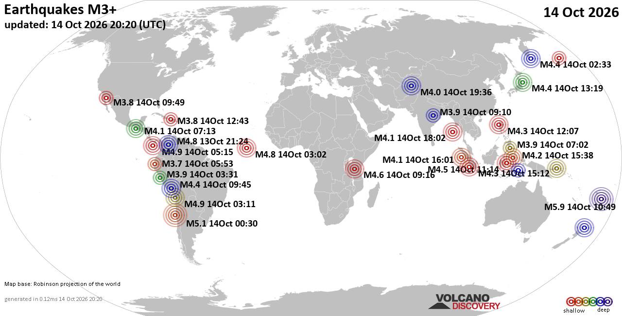
World Earthquake Report for Wednesday, 14 October 2026
• M 0.4 - 9 km WNW of Anza, CA
• M 1.9 - 9 km SW of Susitna, Alaska
• M 1.9 - 27 km NNW of Pāhala, Hawaii
• M 1.1 - 8 km ESE of Cloverdale, CA
• M 1.6 - 7 km ENE of Coleville, California
|
|
|
Joined: Feb 2001
Posts: 678,977
Launch Director
|
|
Launch Director
Joined: Feb 2001
Posts: 678,977 |
SPC MD 2373MD 2373 CONCERNING SEVERE POTENTIAL...WATCH POSSIBLE FOR NORTHWEST TEXAS INTO SOUTHWEST OKLAHOMA 
Mesoscale Discussion 2373
NWS Storm Prediction Center Norman OK
0132 PM CDT Wed Oct 14 2026

Areas affected...northwest Texas into southwest Oklahoma

Concerning...Severe potential...Watch possible

Valid 141832Z - 142130Z

Probability of Watch Issuance...40 percent

SUMMARY...Storms will increase in coverage and intensity over
northwest Texas and develop into southwest Oklahoma through this
afternoon. Scattered strong to damaging gusts or marginal hail will
be possible.

DISCUSSION...An outflow-reinforced boundary is currently settling
south into northwest TX, with some indications of stalling. The air
mass north of this boundary is relatively cool, though areas of
strong heating should eventually aid in destabilization later today.


In the near term, visible imagery shows a prominent CU field in the
vicinity of the boundary, with a stronger cell already affecting
King County TX. Other smaller cells are also developing eastward
near the boundary.

The southwest flow regime ahead of the incoming shortwave trough,
along with increasing low-level southerly winds should aid in air
mass recovery toward the Red River Valley this afternoon, and
farther northeast later this evening as a low-level jet develops.

MLCAPE to 2000 J/kg over TX, along with effective shear of 50-60 kt
will favor cellular storm mode, and marginal hail may occur. Given
the boundary orientation, any tornado risk should be brief as cells
cross to the north.

With such high precipitable water content, substantial outflow is
expected, and a corridor of severe wind gusts may develop should
storms trend toward bowing structures.

..Jewell/Guyer.. 10/14/2026

...Please see www.spc.noaa.gov for graphic product...

ATTN...WFO...OUN...SJT...LUB...

LAT...LON   34399789 33879831 33229938 33010016 32980073 33310084
            33960054 34949940 35079871 34859809 34399789

MOST PROBABLE PEAK TORNADO INTENSITY...UP TO 90 MPH
MOST PROBABLE PEAK WIND GUST...55-70 MPH
MOST PROBABLE PEAK HAIL SIZE...UP TO 1.25 IN
Read morehttps://www.spc.noaa.gov/products/md/md2373.html
|
|



CMS The Best Conveyancing solicitors conveyancing quotes throughout the UK
For any webhosting enquiries please email webmaster@aus-city.com
|
|
Forums60
Topics875,352
Posts910,148
Members2,960
| |
Most Online102,106
Jul 10th, 2026
|
|
|









































