|
|
|
0 members (),
2,863
guests, and
19
robots. |
|
Key:
Admin,
Global Mod,
Mod
|
|
S |
M |
T |
W |
T |
F |
S |
|
1
|
2
|
3
|
4
|
5
|
6
|
7
|
|
8
|
9
|
10
|
11
|
12
|
13
|
14
|
|
15
|
16
|
17
|
18
|
19
|
20
|
21
|
|
22
|
23
|
24
|
25
|
26
|
27
|
28
|
|
29
|
30
|
|
|
|
|
|
|
There are no members with birthdays on this day. |
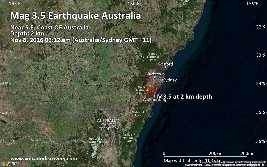
Small magnitude 3.5 earthquake 20 miles northwest of Wollongong, New South Wales, Australia
• Magnitude 3.5 earthquake 20 miles northwest of Wollongong, New South Wales,...
• Possible earthquake reported minutes ago near Wollongong, New South Wales, ...
• World Earthquake Report for Saturday, 7 November 2026
• M 1.3 - 64 km NW of Tatitlek, Alaska
• M 5.5 - 74 km NE of Hasaki, Japan
|

#913451
Thu 15 Oct 2026 01:50:PM
|
Joined: Feb 2001
Posts: 800,656
Launch Director
|
|
Launch Director
Joined: Feb 2001
Posts: 800,656 |
Volcano earthquake report for Thursday, 15 October 2026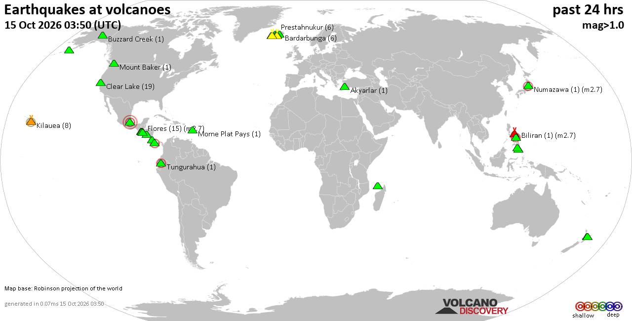 World map showing volcanoes with shallow (less than 50 km) earthquakes within 20 km radius during the past 24 hours on 15 Oct 2026 Number in brackets indicate nr of quakes. Quakes detected near: Agua (7 quakes between mag 0.9-1.8), Akyarlar (1 quake mag 1.3), Balut (5 quakes between mag 1.4-2.8), Bardarbunga (7 quakes between mag 0.4-1.2), Biliran (1 quake mag 2.7), Buzzard Creek (1 quake mag 1.2)
Clear Lake (23 quakes between mag 0.6-3.1), Cosigüina (1 quake mag 2.1), Eldey (3 quakes between mag 1.1-1.8), Fani Maoré (1 quake mag 2.2), Fantale (1 quake mag 4.6), Flores (11 quakes between mag 0.0-2.7), Gagak (2 quakes between mag 3.5-4.1), Kaguyak (1 quake mag 1.0), Katla (3 quakes between mag 0.7-2.4), Kilauea (2 quakes between mag 2.0-2.5), La Malinche (1 quake mag 3.3), Maroa (3 quakes between mag 1.6-2.2), Mayon (1 quake mag 2.5), Mayotte Island (2 quakes between mag 1.1-1.1), Mount Baker (1 quake mag 1.1), Numazawa (1 quake mag 2.7), Parker (1 quake mag 2.2), Prestahnukur (3 quakes between mag 1.0-1.8), Reporoa (4 quakes between mag 1.8-2.2), Salton Buttes (1 quake mag 1.3), Sandal (1 quake mag 1.1), Tecuamburro (1 quake mag 2.2), Tongariro (1 quake mag 1.0), Torfajökull (1 quake mag 1.1), Tungurahua (1 quake mag 2.1) (updated 13h50)\n\nNote: Earthquakes within 20 km from and at depths less than 50 km under active volcanoes are reported. The list is not complete because many volcanoes are not monitored and/or seismic data in high resolution is not available publicly.\n
Volcanoes with recent earthquakes above magnitude 2 or more than 10 quakes are listed below:
Balut volcano (Mindanao): 5 earthquakes up to magnitude 2.85 earthquakes occurred near (under) the volcano during 20 hours, the last being recorded quake 3 hours ago. Hypocenter depths ranged between 34.00 and 2.00 km. Earthquake details: 2.8 quake Province of Davao del Sur, Davao, 45 km south of Malapatan, Philippines, Oct 15, 2026 06:31 pm (GMT +8) (19 km N) 1.9 quake 10.9 km southeast of Sarangani, Davao Occidental, Davao, Philippines, Oct 15, 2026 06:00 am (GMT +8) (19 km ESE) 1.7 quake Celebes Sea, 22 km northwest of Sarangani Island, Philippines, Oct 15, 2026 05:00 pm (GMT +8) (17 km NW) 1.7 quake Philippine Sea, 6.1 km east of Sarangani Island, Philippines, Oct 14, 2026 10:09 pm (GMT +8) (17 km ENE) 1.4 quake Province of Davao del Sur, 4.2 km northwest of Sarangani, Philippines, Oct 15, 2026 03:00 pm (GMT +8) (6 km ENE) All earthquakes at BalutBalut is an 840 m island stratovolcano south of Mindanao whose last known eruption occurred between about 2 million and 11,700 years ago. Hot springs and thermally altered ground occur on its western and southwestern flanks. Biliran volcano (Central Philippines): magnitude 2.7 earthquakeA magnitude 2.7 earthquake occurred at the volcano 18 hours ago. The quake, which might be volcanic in origin, was located at a depth of 11.00 km depth at 15 km distance W from the volcano. Earthquake details: 2.7 quake Philippine Sea, 10.9 km southwest of Biliran Island, Philippines, Oct 15, 2026 03:43 am (GMT +8) (15 km W) All earthquakes at BiliranBiliran is a dome-rich volcanic island across a narrow strait from northern Leyte in the Philippines. Its only known historical eruption was a phreatic explosion with ash and a possible debris avalanche on 26 September 1939. Clear Lake volcano (California): 23 earthquakes up to magnitude 3.1Possible earthquake swarm: 23 earthquakes occurred near (under) the volcano during 17 hours, the last being recorded quake 5 hours ago. Hypocenter depths ranged between 3.52 and 0.38 km. Earthquake details: (only 5 largest) 3.1 quake 26 mi north of Santa Rosa, Sonoma County, California, United States, Oct 14, 2026 11:06 pm (GMT -7) (18 km SSW) 2.3 quake 29 mi north of Santa Rosa, Sonoma County, California, United States, Oct 15, 2026 02:14 am (GMT -7) (18 km SSW) 1.5 quake 28 mi north of Santa Rosa, Sonoma County, California, United States, Oct 14, 2026 04:55 pm (GMT -7) (15 km SSW) 1.4 quake 27 mi north of Santa Rosa, Sonoma County, California, United States, Oct 14, 2026 11:21 pm (GMT -7) (18 km SSW) 1.2 quake Lake County, 28 mi north of Santa Rosa, Sonoma County, California, United States, Oct 14, 2026 02:24 pm (GMT -7) (15 km S) All earthquakes at Clear LakeCosigüina volcano (Nicaragua): magnitude 2.1 earthquakeA magnitude 2.1 earthquake occurred at the volcano 10 hours ago. The quake, which might be volcanic in origin, was located at a depth of 12.00 km depth at 18 km distance W from the volcano. Earthquake details: 2.1 quake North Pacific Ocean, Nicaragua, Oct 14, 2026 09:20 pm (GMT -6) (18 km W) All earthquakes at CosigüinaCosigüina is a Nicaraguan stratovolcano overlooking the Gulf of Fonseca. Its VEI 5 eruption in 1835 was the largest recorded in Nicaragua’s history; the last known eruption occurred in 1859. Fani Maoré volcano (Indian Ocean): magnitude 2.2 earthquakeA magnitude 2.2 earthquake occurred at the volcano 2 hours ago. The quake, which might be volcanic in origin, was located at a depth of 36.76 km depth at 15 km distance NW from the volcano. Earthquake details: 2.2 quake 42 km east of Mamoudzou, Mamoudzou, Mayotte, Oct 15, 2026 02:30 pm (GMT +3) (15 km NW) All earthquakes at Fani MaoréFani Maoré is a submarine volcano about 50 km east of Mayotte. Seismic unrest began in May 2018, and surveys in 2019 discovered a new 800-m-high cone and extensive lava flows on the seafloor. Fantale volcano (Ethiopia): magnitude 4.6 earthquakeA magnitude 4.6 earthquake occurred at the volcano 9 hours ago. The quake, which might be volcanic in origin, was located at a depth of 10.00 km depth at 15 km distance NNW from the volcano. Earthquake details: 4.6 quake Harari Region, 24 km north of Metahara, Oromiya, Ethiopia, Oct 15, 2026 07:41 am (Addis Ababa time) (15 km NNW) All earthquakes at FantaleFantale is an Ethiopian stratovolcano distinguished by a 2.5 x 4.5 km summit caldera and extensive obsidian lava flows. Its only confirmed historical eruptive period occurred around 1789; substantial unrest was also recorded in 2015 and 2024–25. Flores volcano (Guatemala): 11 earthquakes up to magnitude 2.7Possible earthquake swarm: 11 earthquakes occurred near (under) the volcano during 13 hours, the last being recorded quake 10 hours ago. Hypocenter depths ranged between 7.00 and 2.60 km. Earthquake details: (only 5 largest) 2.7 quake 25 km northeast of Cuilapa, Departamento de Santa Rosa, Guatemala, Oct 14, 2026 11:02 am (GMT -6) (14 km NW) 2.4 quake 24 km northeast of Cuilapa, Departamento de Santa Rosa, Guatemala, Oct 14, 2026 04:04 pm (GMT -6) (14 km WNW) 2.4 quake 23 km northeast of Cuilapa, Departamento de Santa Rosa, Guatemala, Oct 14, 2026 09:02 am (GMT -6) (14 km WNW) 2.3 quake 24 km northeast of Cuilapa, Departamento de Santa Rosa, Guatemala, Oct 14, 2026 10:04 pm (GMT -6) (14 km WNW) 2.3 quake 25 km northeast of Cuilapa, Departamento de Santa Rosa, Guatemala, Oct 14, 2026 10:32 am (GMT -6) (14 km NW) All earthquakes at FloresFlores, also known as Volcán Amayo, is a volcanic field about 10 km west of Jutiapa in southeastern Guatemala. Its last eruption is undated, and none are known from approximately the past 11,700 years. Gagak volcano (West Java): 2 earthquakes up to magnitude 4.12 earthquakes occurred near (under) the volcano during 9 minutes, the last being recorded quake 3 hours ago. Hypocenter depths ranged between 10.00 and 10.00 km. Earthquake details: 4.1 quake 20 km west of Cicurug, Kabupaten Sukabumi, Jawa Barat, Indonesia, Oct 15, 2026 05:58 pm (GMT +7) (7 km WSW) 3.5 quake 20 km west of Cicurug, Kabupaten Sukabumi, Jawa Barat, Indonesia, Oct 15, 2026 05:49 pm (GMT +7) (7 km SW) All earthquakes at GagakKatla volcano (Iceland): 3 earthquakes up to magnitude 2.43 earthquakes occurred near (under) the volcano during 18 hours, the last being recorded quake 4 hours ago. Hypocenter depths ranged between 1.50 and 1.10 km. Earthquake details: 2.4 quake 3.2 km NE of Hábunga Oct 14, 2026 03:25 pm (Universal Time) (3 km S) 0.8 quake 3.4 km NNE of Hábunga Oct 14, 2026 03:25 pm (Universal Time) (3 km S) 0.7 quake 4.4 km W of Goðabunga Oct 15, 2026 09:29 am (Universal Time) (14 km W) All earthquakes at KatlaKilauea volcano (Hawai'i (Big Island)): 2 earthquakes up to magnitude 2.52 earthquakes occurred near (under) the volcano during 105 seconds, the last being recorded quake 12 hours ago. Hypocenter depths ranged between 29.33 and 1.57 km. Earthquake details: 2.5 quake 29 mi southwest of Hilo, Hawaii County, Hawaii, United States, Oct 14, 2026 04:09 pm (GMT -10) (8 km SSW) 2.0 quake 37 mi southwest of Hilo, Hawaii County, Hawaii, United States, Oct 14, 2026 04:11 pm (GMT -10) (19 km SSW) All earthquakes at KilaueaLa Malinche volcano (Western & Central Mexico): magnitude 3.3 earthquakeA magnitude 3.3 earthquake occurred at the volcano 17 hours ago. The quake, which might be volcanic in origin, was located at a depth of 10.00 km depth at 19 km distance NE from the volcano. Earthquake details: 3.3 quake 4.4 km north of Huamantla, Estado de Tlaxcala, Mexico, Oct 14, 2026 03:01 pm (GMT -6) (19 km NE) All earthquakes at La MalincheLa Malinche is a deeply eroded stratovolcano northeast of Puebla, with seven known prehistoric eruptive periods. Its last dated eruption occurred around 1170 BCE and produced a lava dome, pyroclastic flows and lahars. Maroa volcano (New Zealand): 3 earthquakes up to magnitude 2.23 earthquakes occurred near (under) the volcano during 1 hour 9 minutes, the last being recorded quake 17 hours ago. Hypocenter depths ranged between 5.00 and 4.90 km. Earthquake details: 2.2 quake 36 km south of Rotorua, Bay of Plenty, New Zealand, Oct 15, 2026 09:21 am (GMT +13) (12 km ESE) 1.9 quake 36 km south of Rotorua, Bay of Plenty, New Zealand, Oct 15, 2026 08:39 am (GMT +13) (12 km ESE) 1.6 quake Bay of Plenty, 192 km northeast of Whanganui, Manawatu-Wanganui, New Zealand, Oct 15, 2026 09:48 am (GMT +13) (11 km ESE) All earthquakes at MaroaMaroa is a New Zealand volcanic centre containing at least 70 mainly rhyolitic lava domes or flows. Its youngest dated magmatic eruption occurred about 14,000 years ago, although younger hydrothermal explosions are known from associated thermal areas. Mayon volcano (Luzon Island): magnitude 2.5 earthquakeA magnitude 2.5 earthquake occurred at the volcano 17 hours ago. The quake, which might be volcanic in origin, was located at a depth of 9.00 km depth at 5 km distance W from the volcano. Earthquake details: 2.5 quake 17 km northwest of Legaspi, Province of Albay, Bicol, Philippines, Oct 15, 2026 05:16 am (GMT +8) (5 km W) All earthquakes at MayonMayon is a symmetrical stratovolcano on Luzon and the most active volcano in the Philippines. Its recorded eruptions date to 1616, and a violent eruption in 1814 killed more than 1,200 people. Numazawa volcano (Honshu): magnitude 2.7 earthquakeA magnitude 2.7 earthquake occurred at the volcano 18 hours ago. The quake, which might be volcanic in origin, was located at a depth of 5.50 km depth at 11 km distance WSW from the volcano. Earthquake details: 2.7 quake 45 km west of Aizu-Wakamatsu, Fukushima, Japan, Oct 15, 2026 05:17 am (GMT +9) (11 km WSW) All earthquakes at NumazawaNumazawa is a Japanese shield volcano with a 1.5 × 2 km lake-filled caldera. Its only listed confirmed eruptive period was a major explosive and effusive event several thousand years ago. Parker volcano (Mindanao): magnitude 2.2 earthquakeA magnitude 2.2 earthquake occurred at the volcano 22 hours ago. The quake, which might be volcanic in origin, was located at a depth of 8.00 km depth at 18 km distance S from the volcano. Earthquake details: 2.2 quake Province of Sarangani, 39 km southwest of General Santos, Philippines, Oct 14, 2026 11:56 pm (GMT +8) (18 km S) All earthquakes at ParkerMélébingóy, formerly known as Parker, is a stratovolcano with a 2.9-km-wide, lake-filled summit caldera on Mindanao. Its major eruption of 1640-41 produced pyroclastic flows, lahars and widespread ash, and was the third large explosive eruption in roughly 3,800 years. Reporoa volcano (New Zealand): 4 earthquakes up to magnitude 2.24 earthquakes occurred near (under) the volcano during 28 minutes, the last being recorded quake 18 hours ago. Hypocenter depths ranged between 5.00 and 4.70 km. Earthquake details: 2.2 quake 36 km south of Rotorua, Bay of Plenty, New Zealand, Oct 15, 2026 09:02 am (GMT +13) (12 km WSW) 2.1 quake 36 km south of Rotorua, Bay of Plenty, New Zealand, Oct 15, 2026 08:52 am (GMT +13) (11 km WSW) 1.9 quake 35 km south of Rotorua, Bay of Plenty, New Zealand, Oct 15, 2026 08:37 am (GMT +13) (11 km WSW) 1.8 quake Bay of Plenty, 27 km northeast of Taupo, Waikato, New Zealand, Oct 15, 2026 09:05 am (GMT +13) (12 km WSW) All earthquakes at ReporoaReporoa is a 10 by 15 km New Zealand caldera formed about 230,000 years ago during the eruption of the Kaingaroa Ignimbrite. No eruption from the caldera is known during approximately the past 12,000 years. Tecuamburro volcano (Guatemala): magnitude 2.2 earthquakeA magnitude 2.2 earthquake occurred at the volcano 23 hours ago. The quake, which might be volcanic in origin, was located at a depth of 38.00 km depth at 18 km distance E from the volcano. Earthquake details: 2.2 quake 15 km southeast of Cuilapa, Departamento de Santa Rosa, Guatemala, Oct 14, 2026 09:02 am (GMT -6) (18 km E) All earthquakes at TecuamburroTecuamburro is a forested stratovolcano and lava-dome complex in Guatemala. Its only dated eruption, about 2,900 years ago, formed the Laguna Ixpaco tuff ring. Tungurahua volcano (Ecuador): magnitude 2.1 earthquakeA magnitude 2.1 earthquake occurred at the volcano 15 hours ago. The quake, which might be volcanic in origin, was located at a depth of 12.00 km depth at 13 km distance NW from the volcano. Earthquake details: 2.1 quake 18 km southeast of Ambato, Tungurahua, Ecuador, Oct 14, 2026 06:06 pm (GMT -5) (13 km NW) All earthquakes at TungurahuaTungurahua is one of Ecuador’s most active volcanoes, rising beside the city of Baños. Its prolonged 1999-2016 activity featured explosive ash emissions, pyroclastic flows, lava flows and lahars. https://www.volcanodiscovery.com/earthquakes-volcanoes/news/378732/Volcano-earthquake-report-2026-10-15.html
|
|



CMS The Best Conveyancing solicitors conveyancing quotes throughout the UK
For any webhosting enquiries please email webmaster@aus-city.com
|
|
Forums60
Topics916,152
Posts950,949
Members2,960
| |
Most Online102,106
Jul 10th, 2026
|
|
|
|
|

|









































