|
|
|
1 members (Alisa),
1,511
guests, and
22
robots. |
|
Key:
Admin,
Global Mod,
Mod
|
|
S |
M |
T |
W |
T |
F |
S |
|
|
|
|
|
1
|
2
|
3
|
|
4
|
5
|
6
|
7
|
8
|
9
|
10
|
|
11
|
12
|
13
|
14
|
15
|
16
|
17
|
|
18
|
19
|
20
|
21
|
22
|
23
|
24
|
|
25
|
26
|
27
|
28
|
29
|
30
|
31
|
|
There are no members with birthdays on this day. |
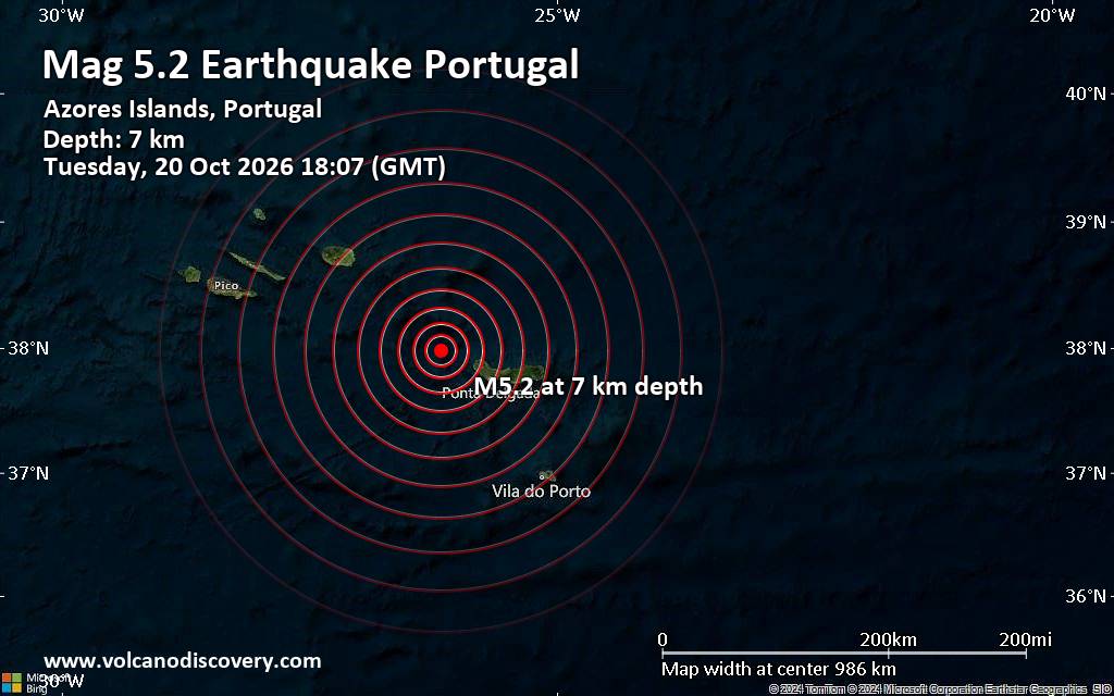
Magnitude 5.2 earthquake strikes near Ponta Delgada, Azores, Portugal
• Possible earthquake reported near Ponta Delgada, Azores, Portugal
• Strong mag. 5.2 earthquake - 10.2 km north of Ponta Delgada, Azores, Portug...
• Magnitude 2.3 quake hits 16 km southwest of Odawara, Japan, early morning
• M 0.4 - 7 km NW of The Geysers, CA
• M 1.9 - 21 km ENE of Denali Park, Alaska
|

#915197
Fri 16 Oct 2026 12:50:PM
|
Joined: Feb 2001
Posts: 678,977
Launch Director
|
|
Launch Director
Joined: Feb 2001
Posts: 678,977 |
Volcano earthquake report for Friday, 16 October 2026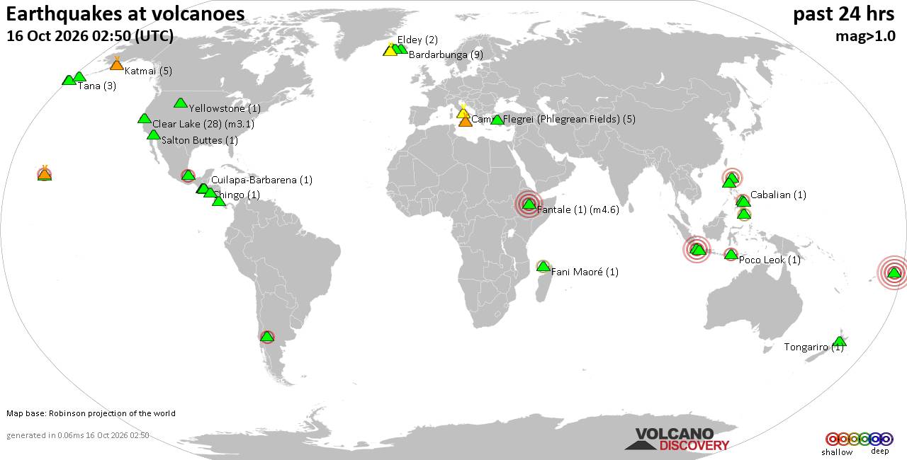 World map showing volcanoes with shallow (less than 50 km) earthquakes within 20 km radius during the past 24 hours on 16 Oct 2026 Number in brackets indicate nr of quakes. Quakes detected near: Balut (3 quakes between mag 2.0-2.8), Bardarbunga (12 quakes between mag 0.1-1.3), Cabalian (1 quake mag 2.2), Cagua (2 quakes between mag 1.8-3.8), Campi Flegrei (Phlegrean Fields) (10 quakes between mag 0.1-1.1), Chingo (1 quake mag 1.4)
Clear Lake (21 quakes between mag 0.2-1.8), Cuilapa-Barbarena (1 quake mag 1.3), Etna (1 quake mag 1.2), Flores (13 quakes between mag 0.9-2.5), Gagak (1 quake mag 2.4), Gran Canaria (2 quakes between mag 1.0-1.9), Irazu (1 quake mag 1.1), Katla (2 quakes between mag 0.8-1.9), Katmai (4 quakes between mag 0.0-1.8), Kilauea (2 quakes between mag 1.9-2.1), Ljósufjöll (18 quakes between mag 0.0-1.4), Loihi (1 quake mag 1.7), Moyuta (1 quake mag 1.6), Niua (1 quake mag 5.2), Pacaya (1 quake mag 3.0), Papandayan (1 quake mag 2.6), Pico de Orizaba (1 quake mag 2.2), Poco Leok (1 quake mag 2.5), Prestahnukur (1 quake mag 1.4), Puesto Cortaderas (1 quake mag 2.6), Redoubt (2 quakes between mag 0.6-1.0), Reporoa (2 quakes between mag 1.7-2.6), Santo Tomas (1 quake mag 1.5), Svartsengi (25 quakes between mag 0.2-1.7), Tambora (1 quake mag 3.9) (updated 12h50)\n\nNote: Earthquakes within 20 km from and at depths less than 50 km under active volcanoes are reported. The list is not complete because many volcanoes are not monitored and/or seismic data in high resolution is not available publicly.\n
Volcanoes with recent earthquakes above magnitude 2 or more than 10 quakes are listed below:
Balut volcano (Mindanao): 3 earthquakes up to magnitude 2.83 earthquakes occurred near (under) the volcano during 10 hours, the last being recorded quake 13 hours ago. Hypocenter depths ranged between 36.00 and 32.00 km. Earthquake details: 2.8 quake Philippine Sea, 5.5 km southwest of Sarangani Island, Philippines, Oct 15, 2026 09:47 pm (GMT +8) (8 km E) 2.0 quake Philippine Sea, 4 km west of Sarangani Island, Philippines, Oct 16, 2026 07:39 am (GMT +8) (8 km ENE) 2.0 quake Celebes Sea, 29 km west of Sarangani Island, Philippines, Oct 15, 2026 11:13 pm (GMT +8) (17 km WSW) All earthquakes at BalutBalut is an 840 m island stratovolcano south of Mindanao whose last known eruption occurred between about 2 million and 11,700 years ago. Hot springs and thermally altered ground occur on its western and southwestern flanks. Bardarbunga volcano (Iceland): 12 earthquakes up to magnitude 1.3Possible earthquake swarm: 12 earthquakes occurred near (under) the volcano during 22 hours, the last being recorded quake 1 hour 5 minutes ago. Hypocenter depths ranged between 17.90 and 0.00 km. Earthquake details: (only 5 largest) 1.3 quake 2.8 km S of Bárðarbunga Oct 15, 2026 08:03 pm (Universal Time) (2 km SSE) 1.0 quake Iceland: 3.2 km SSE of Bárðarbunga Oct 16, 2026 11:45 am (Reykjavik time) (2 km SSE) 0.9 quake Iceland: 3.1 km ESE of Bárðarbunga Oct 16, 2026 11:45 am (Reykjavik time) (3 km E) 0.9 quake 5.1 km SE of Bárðarbunga Oct 16, 2026 01:18 am (Universal Time) (5 km ESE) 0.8 quake 3.1 km S of Bárðarbunga Oct 15, 2026 04:33 pm (Universal Time) (2 km SSE) All earthquakes at BardarbungaBárðarbunga is an ice-covered Icelandic stratovolcano whose far-reaching fissure system has produced enormous lava flows and major explosive eruptions. Its 2014-15 Holuhraun eruption created a lava field of almost 85 km². Cabalian volcano (Central Philippines): magnitude 2.2 earthquakeA magnitude 2.2 earthquake occurred at the volcano 19 hours ago. The quake, which might be volcanic in origin, was located at a depth of 16.00 km depth at 16 km distance WNW from the volcano. Earthquake details: 2.2 quake 36 km northeast of Maasin, Philippines, Oct 16, 2026 02:01 am (GMT +8) (16 km WNW) All earthquakes at CabalianCabalían is a 912 m-high stratovolcano on southeastern Leyte, distinguished by its lake-filled summit crater. Radiocarbon evidence records an eruption around 1820, with an uncertainty of about 30 years. Cagua volcano (Luzon Island): 2 earthquakes up to magnitude 3.82 earthquakes occurred near (under) the volcano during 4 minutes, the last being recorded quake 19 hours ago. Hypocenter depths ranged between 14.00 and 5.00 km. Earthquake details: 3.8 quake 57 km east of Aparri, Province of Cagayan, Cagayan Valley, Philippines, Oct 16, 2026 01:20 am (GMT +8) (7 km NE) 1.8 quake 63 km east of Aparri, Province of Cagayan, Cagayan Valley, Philippines, Oct 16, 2026 01:16 am (GMT +8) (12 km ENE) All earthquakes at CaguaCagua is a forested stratovolcano at the northeastern tip of Luzon, locally called the “Mountain of Fire.” Its last known eruption was a phreatic explosion in 1860 that produced ash and possibly a pyroclastic flow. Clear Lake volcano (California): 21 earthquakes up to magnitude 1.8Possible earthquake swarm: 21 earthquakes occurred near (under) the volcano during 22 hours, the last being recorded quake 41 minutes ago. Hypocenter depths ranged between 8.67 and 0.43 km. Earthquake details: (only 5 largest) 1.8 quake Sonoma County, 15 mi southwest of Clearlake, Lake County, California, United States, Oct 15, 2026 04:55 pm (GMT -7) (18 km SSW) 1.5 quake Sonoma County, 13 mi southwest of Clearlake, Lake County, California, United States, Oct 16, 2026 12:55 am (GMT -7) (17 km S) 1.5 quake 28 mi north of Santa Rosa, Sonoma County, California, United States, Oct 15, 2026 04:54 pm (GMT -7) (18 km SSW) 1.5 quake 28 mi north of Santa Rosa, Sonoma County, California, United States, Oct 15, 2026 04:55 pm (GMT -7) (18 km SSW) 1.1 quake 25 mi north of Santa Rosa, Sonoma County, California, United States, Oct 16, 2026 05:09 am (GMT -7) (19 km S) All earthquakes at Clear LakeFlores volcano (Guatemala): 13 earthquakes up to magnitude 2.5Possible earthquake swarm: 13 earthquakes occurred near (under) the volcano during 21 hours, the last being recorded quake 2 hours ago. Hypocenter depths ranged between 12.80 and 1.30 km. Earthquake details: (only 5 largest) 2.5 quake 26 km west of Jutiapa, Departamento de Jutiapa, Guatemala, Oct 15, 2026 10:25 pm (GMT -6) (14 km WNW) 2.4 quake 24 km northeast of Cuilapa, Departamento de Santa Rosa, Guatemala, Oct 16, 2026 04:25 am (GMT -6) (13 km WNW) 2.1 quake 21 km northeast of Cuilapa, Departamento de Santa Rosa, Guatemala, Oct 15, 2026 12:26 pm (GMT -6) (15 km WNW) 1.8 quake 22 km northeast of Cuilapa, Departamento de Santa Rosa, Guatemala, Oct 15, 2026 05:52 pm (GMT -6) (15 km WNW) 1.8 quake 20 km northeast of Cuilapa, Departamento de Santa Rosa, Guatemala, Oct 15, 2026 10:38 am (GMT -6) (15 km WNW) All earthquakes at FloresFlores, also known as Volcán Amayo, is a volcanic field about 10 km west of Jutiapa in southeastern Guatemala. Its last eruption is undated, and none are known from approximately the past 11,700 years. Gagak volcano (West Java): magnitude 2.4 earthquakeA magnitude 2.4 earthquake occurred at the volcano 9 hours ago. The quake, which might be volcanic in origin, was located at a depth of 10.00 km depth at 8 km distance NW from the volcano. Earthquake details: 2.4 quake 16 km southwest of Ciampea, Bogor Regency, Jawa Barat, Indonesia, Oct 16, 2026 10:21 am (GMT +7) (8 km NW) All earthquakes at GagakKilauea volcano (Hawai'i (Big Island)): 2 earthquakes up to magnitude 2.12 earthquakes occurred near (under) the volcano during 22 hours, the last being recorded quake 52 minutes ago. Hypocenter depths ranged between 5.51 and 1.84 km. Earthquake details: 2.1 quake 26 mi southwest of Hilo, Hawaii County, Hawaii, United States, Oct 15, 2026 04:08 am (GMT -10) (3 km SSE) 1.9 quake 12 mi west of Volcano, Hawaii County, Hawaii, United States, Oct 16, 2026 01:57 am (GMT -10) (13 km WSW) All earthquakes at KilaueaLjósufjöll volcano (Iceland): 18 earthquakes up to magnitude 1.4Possible earthquake swarm: 18 earthquakes occurred near (under) the volcano during 7 hours, the last being recorded quake 15 hours ago. Hypocenter depths ranged between 21.00 and 0.00 km. Earthquake details: (only 5 largest) 1.4 quake 33.1 km N of Borgarnes Oct 15, 2026 05:43 pm (Universal Time) (14 km E) 1.2 quake Iceland: 32.6 km N of Borgarnes Oct 15, 2026 06:13 pm (Reykjavik time) (13 km ESE) 1.0 quake Iceland: 25.7 km N of Borgarnes Oct 15, 2026 06:17 pm (Reykjavik time) (16 km SE) 0.8 quake Iceland: 30.7 km N of Borgarnes Oct 15, 2026 06:17 pm (Reykjavik time) (14 km ESE) 0.5 quake Iceland: 25.5 km N of Borgarnes Oct 15, 2026 05:32 pm (Reykjavik time) (17 km SE) All earthquakes at LjósufjöllLjósufjöll is an Icelandic volcanic field with evidence of repeated activity during the past 10,000 years. Its last known eruption occurred around 960 CE and combined explosive activity with lava production. Niua volcano (Tonga): magnitude 5.2 earthquakeA magnitude 5.2 earthquake occurred at the volcano 23 hours ago. The quake, which might be volcanic in origin, was located at a depth of 10.00 km depth at 14 km distance NE from the volcano. Earthquake details: 5.2 quake South Pacific Ocean, 225 km southwest of Apia, Tuamasaga, Samoa, Oct 16, 2026 02:29 am (GMT +13) (14 km NE) All earthquakes at NiuaNiua is a large, irregular submarine volcanic complex in Tonga. Its last known eruption occurred more than approximately 11,700 years ago. Pacaya volcano (Guatemala): magnitude 3.0 earthquakeA magnitude 3.0 earthquake occurred at the volcano 37 minutes ago. The quake, which might be volcanic in origin, was located at a depth of 10.00 km depth at 13 km distance N from the volcano. Earthquake details: Unconfirmed quake or seismic-like event reported: 19 km southwest of Guatemala City, Departamento de Guatemala, Guatemala, Oct 16, 2026 06:12 am (GMT -6) (13 km N) All earthquakes at PacayaPacaya, about 30 km south of Guatemala City, has frequently produced Strombolian explosions, ash plumes and lava flows. Its last known eruption continued from 2015 to August 2021. Papandayan volcano (West Java): magnitude 2.6 earthquakeA magnitude 2.6 earthquake occurred at the volcano 21 hours ago. The quake, which might be volcanic in origin, was located at a depth of 12.00 km depth at 12 km distance NNW from the volcano. Earthquake details: 2.6 quake 19 km southwest of Paseh, Kabupaten Bandung, Jawa Barat, Indonesia, Oct 15, 2026 10:32 pm (GMT +7) (12 km NNW) All earthquakes at PapandayanPapandayan is an active Indonesian stratovolcano whose 1772 eruption and flank collapse destroyed 40 villages and killed almost 3,000 people. Its crater complex remains marked by strong fumarolic activity. Pico de Orizaba volcano (Western & Central Mexico): magnitude 2.2 earthquakeA magnitude 2.2 earthquake occurred at the volcano 23 hours ago. The quake, which might be volcanic in origin, was located at a depth of 7.90 km depth at 5 km distance NNE from the volcano. Earthquake details: 2.2 quake 29 km northwest of Orizaba, Estado de Veracruz-Llave, Mexico, Oct 15, 2026 07:28 am (GMT -6) (5 km NNE) All earthquakes at Pico de OrizabaPico de Orizaba is Mexico’s highest peak and North America’s highest volcano. Its last known eruption was a minor ash event in 1846. Poco Leok volcano (Flores): magnitude 2.5 earthquakeA magnitude 2.5 earthquake occurred at the volcano 17 hours ago. The quake, which might be volcanic in origin, was located at a depth of 10.00 km depth at 11 km distance WNW from the volcano. Earthquake details: 2.5 quake 8.4 km west of Ruteng, Kabupaten Manggarai, East Nusa Tenggara, Indonesia, Oct 16, 2026 03:41 am (GMT +8) (11 km WNW) All earthquakes at Poco LeokPoco Leok is a 1,675 m stratovolcano on western Flores Island with several fumarole fields and the Ulumbu geothermal area. No eruption is known from approximately the past 12,000 years. Puesto Cortaderas volcano (Central Chile and Argentina): magnitude 2.6 earthquakeA magnitude 2.6 earthquake occurred at the volcano 22 hours ago. The quake, which might be volcanic in origin, was located at a depth of 10.00 km depth at 18 km distance E from the volcano. Earthquake details: 2.6 quake Pehuenches, 77 km east of Chos Malal, Departamento de Chos-Malal, Neuquen Province, Argentina, Oct 15, 2026 11:27 am (GMT -3) (18 km E) All earthquakes at Puesto CortaderasReporoa volcano (New Zealand): 2 earthquakes up to magnitude 2.62 earthquakes occurred near (under) the volcano during 3 hours, the last being recorded quake 3 hours ago. Hypocenter depths ranged between 31.10 and 6.30 km. Earthquake details: 2.6 quake 28 km southeast of Rotorua, Bay of Plenty, New Zealand, Oct 16, 2026 07:28 pm (GMT +13) (17 km NE) 1.7 quake 36 km south of Rotorua, Bay of Plenty, New Zealand, Oct 16, 2026 10:31 pm (GMT +13) (12 km WSW) All earthquakes at ReporoaReporoa is a 10 by 15 km New Zealand caldera formed about 230,000 years ago during the eruption of the Kaingaroa Ignimbrite. No eruption from the caldera is known during approximately the past 12,000 years. Svartsengi volcano (Reykjanes Peninsula, Iceland): 25 earthquakes up to magnitude 1.7Possible earthquake swarm: 25 earthquakes occurred near (under) the volcano during 18 hours, the last being recorded quake 3 hours ago. Hypocenter depths ranged between 11.30 and 0.00 km. Earthquake details: (only 5 largest) 1.7 quake 4.4 km N of Reykjanestá Oct 16, 2026 09:46 am (Universal Time) (3 km NNE) 1.5 quake 7.2 km WNW of Reykjanestá Oct 16, 2026 03:55 am (Universal Time) (6 km WNW) 1.4 quake Iceland: 6.6 km WNW of Reykjanestá Oct 16, 2026 03:07 am (Reykjavik time) (6 km W) 1.3 quake 5.9 km WNW of Reykjanestá Oct 16, 2026 03:07 am (Universal Time) (5 km WNW) 1.3 quake 7.3 km WNW of Reykjanestá Oct 16, 2026 02:24 am (Universal Time) (6 km WNW) All earthquakes at SvartsengiSvartsengi is a fissure-dominated volcanic system on Iceland’s Reykjanes Peninsula. Repeated lava-producing eruptions occurred near Sundhnúkagígar from December 2023 through August 2025. Tambora volcano (Sumbawa): magnitude 3.9 earthquakeA magnitude 3.9 earthquake occurred at the volcano 9 hours ago. The quake, which might be volcanic in origin, was located at a depth of 10.00 km depth at 18 km distance NNW from the volcano. Earthquake details: 3.9 quake Kabupaten Bima, 72 km northeast of Sumbawa Besar, Indonesia, Oct 16, 2026 12:03 pm (GMT +8) (18 km NNW) All earthquakes at Tamborahttps://www.volcanodiscovery.com/earthquakes-volcanoes/news/379569/Volcano-earthquake-report-2026-10-16.html
|
|



CMS The Best Conveyancing solicitors conveyancing quotes throughout the UK
For any webhosting enquiries please email webmaster@aus-city.com
|
|
Forums60
Topics885,285
Posts920,082
Members2,960
| |
Most Online102,106
Jul 10th, 2026
|
|
|
|
|

|









































