|
1 members (Alisa),
1,396
guests, and
26
robots. |
|
Key:
Admin,
Global Mod,
Mod
|
|
S |
M |
T |
W |
T |
F |
S |
|
|
|
|
|
1
|
2
|
3
|
|
4
|
5
|
6
|
7
|
8
|
9
|
10
|
|
11
|
12
|
13
|
14
|
15
|
16
|
17
|
|
18
|
19
|
20
|
21
|
22
|
23
|
24
|
|
25
|
26
|
27
|
28
|
29
|
30
|
31
|
|
There are no members with birthdays on this day. |
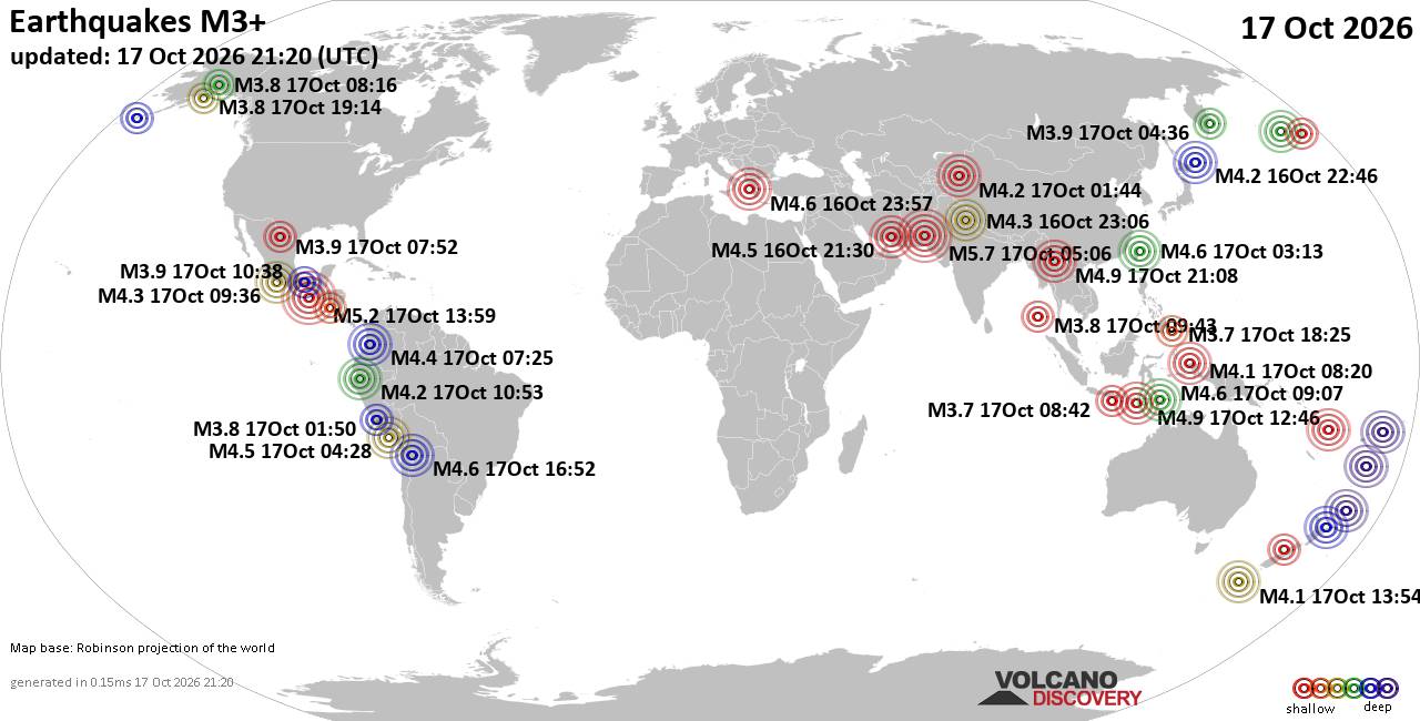
World Earthquake Report for Saturday, 17 October 2026
• Moderate mag. 4.9 earthquake - China on Saturday, Oct 17, 2026, at 09:08 pm...
• M 0.9 - 22 km ESE of Anza, CA
• Light mag. 3.9 earthquake - Hawke's Bay, New Zealand, on Sunday, Oct 18, 20...
• M 1.8 - 9 km SSW of Volcano, Hawaii
• M 1.1 - 55 km E of Whittier, Alaska
|
|
|
Joined: Feb 2001
Posts: 678,977
Launch Director
|
|
Launch Director
Joined: Feb 2001
Posts: 678,977 |
SPC Day 2 Fire Weather OutlookSPC Day 2 Fire Weather Outlook 
Day 2 Fire Weather Outlook
NWS Storm Prediction Center Norman OK
0225 PM CDT Sat Oct 17 2026

Valid 181200Z - 191200Z

...NO CRITICAL AREAS...

The Day 2/Sunday fire weather forecast remains on track; please see
the previous discussion for details.

..Elizalde-Garcia.. 10/17/2026

.PREV DISCUSSION... /ISSUED 0155 AM CDT Sat Oct 17 2026/

...Synopsis...
A closed mid-level low will remain positioned off of the East Coast
on D2/Sunday as upper ridging lingers across the southern Plains and
lower/mid Mississippi River Valley. Simultaneously, a robust
mid/upper level shortwave trough will begin to approach the Pacific
Northwest coastline. At the surface, high pressure will build into
the northern Plains behind a southeastward-progressing cold front,
while a second area of high pressure persists across the
Mid-Atlantic. Recent widespread precipitation across much of the
Intermountain West, Plains, and East will largely temper fire
weather concerns across these regions.

Dry and breezy conditions are forecast across portions the
southern/central High Plains in advance of lee surface troughing and
across portions of the Southeast, including central/northern Georgia
and adjacent areas of South Carolina/Alabama along the southern
periphery of surface high pressure to the north. Poor to marginal
fuel conditions, recent rainfall across portions of these areas, and
marginal wind speeds across the Southeast are expected to limit the
overall fire weather threat across these regions at this time,
however.

Some 00z high-res guidance also suggests that southwesterly surface
winds will begin to strengthen across portions of northeastern
California, southern/southeastern Oregon, and northwestern Nevada
Sunday afternoon in advance of the approaching shortwave trough.
Guidance differs on the magnitude of sustained surface winds as well
as minimum daytime RH reductions, however. Thus, confidence
regarding an extended (3+ hour) overlap of elevated wind/RH criteria
is low at this time, but locally elevated conditions may materialize
should stronger sustained surface winds overlap lower RH values
Sunday afternoon.

...Please see www.spc.noaa.gov/fire for graphic product...
Read morehttps://www.spc.noaa.gov/products/fire_wx/fwdy2.html
|
|



CMS The Best Conveyancing solicitors conveyancing quotes throughout the UK
For any webhosting enquiries please email webmaster@aus-city.com
|
|
Forums60
Topics880,529
Posts915,326
Members2,960
| |
Most Online102,106
Jul 10th, 2026
|
|
|









































