|
|
|
0 members (),
2,416
guests, and
26
robots. |
|
Key:
Admin,
Global Mod,
Mod
|
|
S |
M |
T |
W |
T |
F |
S |
|
1
|
2
|
3
|
4
|
5
|
6
|
7
|
|
8
|
9
|
10
|
11
|
12
|
13
|
14
|
|
15
|
16
|
17
|
18
|
19
|
20
|
21
|
|
22
|
23
|
24
|
25
|
26
|
27
|
28
|
|
29
|
30
|
|
|
|
|
|
|
There are no members with birthdays on this day. |
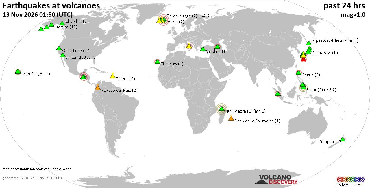
Volcano earthquake report for Friday, 13 November 2026
• M 3.4 - 54 km N of Kobuk, Alaska
• Moderate mag. 4.9 earthquake - Northern Mariana Islands: Mariana Islands on...
• M 1.6 - 28 km WSW of Salamatof, Alaska
• M -0.7 - 66 km ENE of Pedro Bay, Alaska
• M 0.6 - 89 km SE of Kokhanok, Alaska
• M 0.7 - 90 km SE of Kokhanok, Alaska
|

#921242
Tue 20 Oct 2026 07:50:AM
|
Joined: Feb 2001
Posts: 800,656
Launch Director
|
|
Launch Director
Joined: Feb 2001
Posts: 800,656 |
Volcano earthquake report for Tuesday, 20 October 2026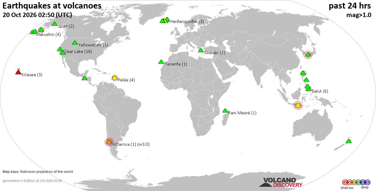 World map showing volcanoes with shallow (less than 50 km) earthquakes within 20 km radius during the past 24 hours on 20 Oct 2026 Number in brackets indicate nr of quakes. Quakes detected near: Agung (1 quake mag 3.2), Balut (6 quakes between mag 1.4-2.9), Bardarbunga (27 quakes between mag 0.0-5.3), Brennisteinsfjöll (2 quakes between mag 0.4-1.9), Clear Lake (21 quakes between mag 0.2-1.8), Coso (2 quakes between mag 0.6-1.2)
Fani Maoré (1 quake mag 1.6), Flores (6 quakes between mag 1.4-1.9), Grímsnes (1 quake mag 1.5), Heiðarsporðar (3 quakes between mag 0.2-1.4), Irazu (1 quake mag 1.6), Katla (1 quake mag 1.5), Krísuvík (1 quake mag 1.0), Loihi (1 quake mag 2.3), Makushin (4 quakes between mag 0.2-1.4), Maunaloa (1 quake mag 1.3), Pelée (3 quakes between mag 0.1-2.2), Pocdol Mountains (1 quake mag 1.6), Prestahnukur (1 quake mag 2.0), Ragang (1 quake mag 1.6), Sousaki (2 quakes between mag 1.5-1.8), Stepovak Bay 4 (1 quake mag 2.3), Taupo (1 quake mag 1.8), Tenerife (1 quake mag 1.4), Torfajökull (2 quakes between mag 1.3-1.7), Villarrica (1 quake mag 3.0), Yellowstone (2 quakes between mag 0.9-1.1) (updated 07h50)\n\nNote: Earthquakes within 20 km from and at depths less than 50 km under active volcanoes are reported. The list is not complete because many volcanoes are not monitored and/or seismic data in high resolution is not available publicly.\n
Volcanoes with recent earthquakes above magnitude 2 or more than 10 quakes are listed below:
Agung volcano (Bali): magnitude 3.2 earthquakeA magnitude 3.2 earthquake occurred at the volcano 17 hours ago. The quake, which might be volcanic in origin, was located at a depth of 12.00 km depth at 18 km distance NNE from the volcano. Earthquake details: 3.2 quake Bali Region, Indonesia, Oct 19, 2026 11:07 pm (GMT +8) (18 km NNE) All earthquakes at AgungAgung volcano in eastern Bali, Indonesia, is the island's highest and most active volcano. Balut volcano (Mindanao): 6 earthquakes up to magnitude 2.96 earthquakes occurred near (under) the volcano during 15 hours, the last being recorded quake 1 hour 48 minutes ago. Hypocenter depths ranged between 39.00 and 29.00 km. Earthquake details: (only 5 largest) 2.9 quake Philippines: 008 km S 52° W of Balut Island (Municipality of Sarangani) (Davao Occidental) Oct 20, 2026 02:02 pm (GMT +8) (3 km SSW) 2.3 quake Mindanao, Philippines, Oct 20, 2026 12:48 pm (GMT +8) (10 km W) 1.5 quake Philippines: 003 km S 04° E of Balut Island (Municipality of Sarangani) (Davao Occidental) Oct 20, 2026 04:38 am (GMT +8) (5 km E) 1.5 quake 014 km S 83° W of Balut Island (Municipality of Sarangani) (Davao Occidental) Oct 19, 2026 11:20 pm (GMT +8) (8 km W) 1.4 quake Philippines: 013 km N 84° W of Balut Island (Municipality of Sarangani) (Davao Occidental) Oct 20, 2026 06:22 am (GMT +8) (9 km WNW) All earthquakes at BalutBalut is an 840 m island stratovolcano south of Mindanao whose last known eruption occurred between about 2 million and 11,700 years ago. Hot springs and thermally altered ground occur on its western and southwestern flanks. Bardarbunga volcano (Iceland): 27 earthquakes up to magnitude 5.3Possible earthquake swarm: 27 earthquakes occurred near (under) the volcano during 17 hours, the last being recorded quake 4 hours ago. Hypocenter depths ranged between 18.30 and 0.00 km. Earthquake details: (only 5 largest) 5.3 quake 116 km WNW of Höfn, Iceland, Oct 19, 2026 02:44 pm (Reykjavik time) (6 km S) 3.4 quake Iceland Oct 19, 2026 12:51 pm (Reykjavik time) (4 km ESE) 2.8 quake Iceland Oct 19, 2026 01:39 pm (Reykjavik time) (5 km ESE) 2.7 quake 5.6 km ESE of Bárðarbunga Oct 19, 2026 12:50 pm (Universal Time) (5 km ESE) 2.3 quake 1.6 km SSE of Bárðarbunga Oct 19, 2026 01:38 pm (Universal Time) (1 km ESE) All earthquakes at BardarbungaBárðarbunga is an ice-covered Icelandic stratovolcano whose far-reaching fissure system has produced enormous lava flows and major explosive eruptions. Its 2014-15 Holuhraun eruption created a lava field of almost 85 km². Clear Lake volcano (California): 21 earthquakes up to magnitude 1.8Possible earthquake swarm: 21 earthquakes occurred near (under) the volcano during 22 hours, the last being recorded quake 1 hour 37 minutes ago. Hypocenter depths ranged between 3.66 and 0.09 km. Earthquake details: (only 5 largest) 1.8 quake 4 km NW of the Geysers, CA, Oct 19, 2026 10:46 pm (GMT -7) (19 km S) 1.3 quake 5 km WNW of Cobb, CA, Oct 19, 2026 08:31 pm (GMT -7) (15 km S) 1.2 quake 7 km WNW of Cobb, CA, Oct 19, 2026 09:10 am (GMT -7) (15 km S) 1.1 quake 6 km WNW of Cobb, CA, Oct 19, 2026 11:13 pm (GMT -7) (15 km S) 1.1 quake 6 km WNW of the Geysers, CA, Oct 19, 2026 05:29 pm (GMT -7) (19 km SSW) All earthquakes at Clear LakeLoihi volcano (Hawai'i (Big Island)): magnitude 2.3 earthquakeA magnitude 2.3 earthquake occurred at the volcano 3 hours ago. The quake, which might be volcanic in origin, was located at a depth of 34.15 km depth at 17 km distance NW from the volcano. Earthquake details: 2.3 quake 21 km SE of Pāhala, Hawaii, Oct 19, 2026 06:45 pm (GMT -10) (17 km NW) All earthquakes at LoihiLoihi, now named Kamaʻehuakanaloa, is a submarine shield volcano about 35 km southeast of Hawaiʻi. Its last confirmed eruption was in 1996, while later unrest has consisted of earthquake swarms without confirmed eruptions. Pelée volcano (Caribbean): 3 earthquakes up to magnitude 2.23 earthquakes occurred near (under) the volcano during 16 hours, the last being recorded quake 7 hours ago. Hypocenter depths ranged between 0.29 and 0.20 km. Earthquake details: 2.2 quake Earthquake of Magnitude 2.2, Near Fort-De-France, Oct 19, 2026 08:18 pm (GMT -4) (0 km SSW) 0.1 quake Earthquake of Magnitude 0.1, Near Fort-De-France, Oct 19, 2026 08:21 pm (GMT -4) (0 km NW) 0.1 quake Earthquake of Magnitude 0.1, Near Fort-De-France, Oct 19, 2026 04:43 am (GMT -4) (0 km NNE) All earthquakes at PeléePelée is the Martinique stratovolcano whose catastrophic 1902 eruption destroyed Saint-Pierre and became the defining example of Peléan eruptions. Its last known eruption ended in 1932. Stepovak Bay 4 volcano (Alaska Peninsula): magnitude 2.3 earthquakeA magnitude 2.3 earthquake occurred at the volcano 7 hours ago. The quake, which might be volcanic in origin, was located at a depth of 8.10 km depth at 7 km distance SE from the volcano. Earthquake details: 2.3 quake 25 km W of Ivanof Bay, Alaska, Oct 19, 2026 04:55 pm (GMT -8) (7 km SE) All earthquakes at Stepovak Bay 4Villarrica volcano (Central Chile and Argentina): magnitude 3.0 earthquakeA magnitude 3.0 earthquake occurred at the volcano 23 hours ago. The quake, which might be volcanic in origin, was located at a depth of 10.00 km depth at 16 km distance NNW from the volcano. Earthquake details: Reported quake or seismic-like event: Near Villarrica, Araucanía, Chile, Oct 19, 2026 05:39 am (GMT -3) (16 km NNW) All earthquakes at VillarricaVillarrica is a frequently active, glacier-covered Chilean stratovolcano known for Strombolian explosions and a summit lava lake. Its eruptions have also produced lava flows, ash, pyroclastic flows and deadly lahars. https://www.volcanodiscovery.com/earthquakes-volcanoes/news/383142/Volcano-earthquake-report-2026-10-20.html
|
|



CMS The Best Conveyancing solicitors conveyancing quotes throughout the UK
For any webhosting enquiries please email webmaster@aus-city.com
|
|
Forums60
Topics925,284
Posts960,081
Members2,960
| |
Most Online102,106
Jul 10th, 2026
|
|
|
|
|

|









































