|
|
|
1 members (Alisa),
1,769
guests, and
28
robots. |
|
Key:
Admin,
Global Mod,
Mod
|
|
S |
M |
T |
W |
T |
F |
S |
|
|
|
|
|
1
|
2
|
3
|
|
4
|
5
|
6
|
7
|
8
|
9
|
10
|
|
11
|
12
|
13
|
14
|
15
|
16
|
17
|
|
18
|
19
|
20
|
21
|
22
|
23
|
24
|
|
25
|
26
|
27
|
28
|
29
|
30
|
31
|
|
There are no members with birthdays on this day. |
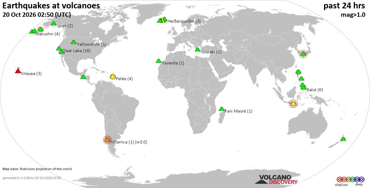
Volcano earthquake report for Tuesday, 20 October 2026
• Moderate mag. 4.0 earthquake - South OF Sumbawa, Indonesia, on Tuesday, Oct...
• M 1.6 - 6 km NE of Aguanga, CA
• M 1.5 - 21 km S of Lindsay, Texas
• M 2.6 - 18 km SSW of Jal, New Mexico
• M 2.0 - 19 km ESE of Naalehu, Hawaii
|
|
|
Joined: Feb 2001
Posts: 678,977
Launch Director
|
|
Launch Director
Joined: Feb 2001
Posts: 678,977 |
Volcano earthquake report for Tuesday, 20 October 2026World map showing volcanoes with shallow (less than 50 km) earthquakes within 20 km radius during the past 24 hours on 20 Oct 2026 Number in brackets indicate nr of quakes. Quakes detected near: Agung (1 quake mag 3.2), Apaneca Range (8 quakes between mag 2.2-3.1), Balut (6 quakes between mag 1.4-2.9), Bardarbunga (34 quakes between mag 0.0-5.3), Brennisteinsfjöll (2 quakes between mag 0.3-1.9), Clear Lake (18 quakes between mag 0.2-1.8)
Coso (2 quakes between mag 0.6-1.2), Etna (1 quake mag 1.8), Fani Maoré (1 quake mag 1.3), Flores (6 quakes between mag 1.4-2.1), Grímsnes (1 quake mag 1.5), Heiðarsporðar (2 quakes between mag 0.2-1.4), Irazu (1 quake mag 1.6), Katla (1 quake mag 1.5), Kilauea (4 quakes between mag 2.1-2.8), Ljósufjöll (11 quakes between mag 0.0-1.0), Loihi (1 quake mag 2.3), Makushin (4 quakes between mag 0.2-1.4), Maunaloa (1 quake mag 1.3), Pelée (2 quakes between mag 0.1-2.2), Pocdol Mountains (1 quake mag 1.6), Prestahnukur (1 quake mag 2.0), Ragang (1 quake mag 1.6), Sandal (1 quake mag 1.3), Sousaki (3 quakes between mag 1.5-2.4), Stepovak Bay 4 (1 quake mag 2.3), Svartsengi (1 quake mag 1.2), Taupo (1 quake mag 1.8), Tenerife (1 quake mag 1.4), Torfajökull (2 quakes between mag 1.3-1.7), Yellowstone (2 quakes between mag 0.9-1.1) (updated 11h50)\n\nNote: Earthquakes within 20 km from and at depths less than 50 km under active volcanoes are reported. The list is not complete because many volcanoes are not monitored and/or seismic data in high resolution is not available publicly.\n
Volcanoes with recent earthquakes above magnitude 2 or more than 10 quakes are listed below:
Agung volcano (Bali): magnitude 3.2 earthquakeA magnitude 3.2 earthquake occurred at the volcano 21 hours ago. The quake, which might be volcanic in origin, was located at a depth of 12.00 km depth at 18 km distance NNE from the volcano. Earthquake details: 3.2 quake Bali Sea, 28 km north of Amlapura, Indonesia, Oct 19, 2026 11:07 pm (GMT +8) (18 km NNE) All earthquakes at AgungAgung volcano in eastern Bali, Indonesia, is the island's highest and most active volcano. Apaneca Range volcano (El Salvador): 8 earthquakes up to magnitude 3.18 earthquakes occurred near (under) the volcano during 6 hours, the last being recorded quake 1 hour 1 minutes ago. Hypocenter depths ranged between 15.40 and 3.50 km. Earthquake details: (only 5 largest) 3.1 quake 10.4 km southeast of Ahuachapan, Departamento de Ahuachapan, El Salvador, Oct 19, 2026 10:35 pm (GMT -6) (6 km WSW) 3.1 quake 9.7 km southeast of Ahuachapan, Departamento de Ahuachapan, El Salvador, Oct 20, 2026 04:35 am (GMT -6) (5 km WSW) 3.1 quake 9.7 km southeast of Ahuachapan, Departamento de Ahuachapan, El Salvador, Oct 20, 2026 04:35 am (GMT -6) (4 km WSW) 2.9 quake 10.1 km southeast of Ahuachapan, Departamento de Ahuachapan, El Salvador, Oct 20, 2026 04:30 am (GMT -6) (4 km WSW) 2.9 quake 20 km north of Sonsonate, Departamento de Sonsonate, El Salvador, Oct 20, 2026 04:28 am (GMT -6) (3 km NNW) All earthquakes at Apaneca RangeThe Apaneca Range is a chain of stratovolcanoes, lava domes and thermal areas in western El Salvador. Its dated eruptive history is uncertain, but deadly hydrothermal activity occurred at Agua Shuca in 1990, followed by another explosion there in July 2025. Balut volcano (Mindanao): 6 earthquakes up to magnitude 2.96 earthquakes occurred near (under) the volcano during 15 hours, the last being recorded quake 6 hours ago. Hypocenter depths ranged between 39.00 and 29.00 km. Earthquake details: (only 5 largest) 2.9 quake 11 km west of Sarangani, Davao Occidental, Davao, Philippines, Oct 20, 2026 02:02 pm (GMT +8) (3 km SSW) 2.3 quake Davao Occidental, Davao, Philippines, Oct 20, 2026 12:48 pm (GMT +8) (10 km W) 1.5 quake Province of Davao del Sur, 5.1 km west of Sarangani, Philippines, Oct 20, 2026 04:38 am (GMT +8) (5 km E) 1.5 quake Celebes Sea, 20 km west of Sarangani Island, Philippines, Oct 19, 2026 11:20 pm (GMT +8) (8 km W) 1.4 quake Celebes Sea, 20 km west of Sarangani Island, Philippines, Oct 20, 2026 06:22 am (GMT +8) (9 km WNW) All earthquakes at BalutBalut is an 840 m island stratovolcano south of Mindanao whose last known eruption occurred between about 2 million and 11,700 years ago. Hot springs and thermally altered ground occur on its western and southwestern flanks. Bardarbunga volcano (Iceland): 34 earthquakes up to magnitude 5.3Possible earthquake swarm: 34 earthquakes occurred near (under) the volcano during 20 hours, the last being recorded quake 4 hours ago. Hypocenter depths ranged between 18.30 and 0.00 km. Earthquake details: (only 5 largest) 5.3 quake South, 217 km east of Reykjavik, Capital Region, Iceland, Oct 19, 2026 02:44 pm (Reykjavik time) (6 km S) 3.4 quake Northeast, 220 km east of Reykjavik, Capital Region, Iceland, Oct 19, 2026 12:51 pm (Universal Time) (4 km ESE) 2.8 quake Northeast, 222 km east of Reykjavik, Capital Region, Iceland, Oct 19, 2026 01:39 pm (Reykjavik time) (5 km ESE) 2.7 quake 5.6 km ESE of Bárðarbunga Oct 19, 2026 12:50 pm (Universal Time) (5 km ESE) 2.3 quake 1.6 km SSE of Bárðarbunga Oct 19, 2026 01:38 pm (Universal Time) (1 km ESE) All earthquakes at BardarbungaBárðarbunga is an ice-covered Icelandic stratovolcano whose far-reaching fissure system has produced enormous lava flows and major explosive eruptions. Its 2014-15 Holuhraun eruption created a lava field of almost 85 km². Clear Lake volcano (California): 18 earthquakes up to magnitude 1.8Possible earthquake swarm: 18 earthquakes occurred near (under) the volcano during 22 hours, the last being recorded quake 36 minutes ago. Hypocenter depths ranged between 3.66 and 0.09 km. Earthquake details: (only 5 largest) 1.8 quake Sonoma County, 14 mi southwest of Clearlake, Lake County, California, United States, Oct 19, 2026 10:46 pm (GMT -7) (19 km S) 1.7 quake 10.7 mi southwest of Clearlake, Lake County, California, United States, Oct 20, 2026 04:13 am (GMT -7) (15 km S) 1.3 quake Lake County, 28 mi north of Santa Rosa, Sonoma County, California, United States, Oct 19, 2026 08:31 pm (GMT -7) (15 km S) 1.2 quake Lake County, 28 mi north of Santa Rosa, Sonoma County, California, United States, Oct 19, 2026 09:10 am (GMT -7) (15 km S) 1.1 quake Lake County, 28 mi north of Santa Rosa, Sonoma County, California, United States, Oct 19, 2026 11:13 pm (GMT -7) (15 km S) All earthquakes at Clear LakeFlores volcano (Guatemala): 6 earthquakes up to magnitude 2.16 earthquakes occurred near (under) the volcano during 22 hours, the last being recorded quake 1 hour 20 minutes ago. Hypocenter depths ranged between 14.90 and 5.00 km. Earthquake details: (only 5 largest) 2.1 quake 24 km northeast of Cuilapa, Departamento de Santa Rosa, Guatemala, Oct 20, 2026 04:30 am (GMT -6) (14 km NW) 1.9 quake 22 km northeast of Cuilapa, Departamento de Santa Rosa, Guatemala, Oct 19, 2026 02:10 pm (GMT -6) (14 km WNW) 1.8 quake 26 km west of Jutiapa, Departamento de Jutiapa, Guatemala, Oct 19, 2026 06:14 am (GMT -6) (14 km WNW) 1.6 quake 25 km west of Jutiapa, Departamento de Jutiapa, Guatemala, Oct 19, 2026 08:37 am (GMT -6) (14 km WNW) 1.5 quake 21 km northeast of Cuilapa, Departamento de Santa Rosa, Guatemala, Oct 19, 2026 01:39 pm (GMT -6) (15 km WNW) All earthquakes at FloresFlores, also known as Volcán Amayo, is a volcanic field about 10 km west of Jutiapa in southeastern Guatemala. Its last eruption is undated, and none are known from approximately the past 11,700 years. Kilauea volcano (Hawai'i (Big Island)): 4 earthquakes up to magnitude 2.84 earthquakes occurred near (under) the volcano during 24 minutes, the last being recorded quake 3 hours ago. Hypocenter depths ranged between 39.47 and 0.14 km. Earthquake details: 2.8 quake 25 mi southwest of Hilo, Hawaii County, Hawaii, United States, Oct 19, 2026 10:40 pm (GMT -10) (6 km ESE) 2.7 quake 25 mi southwest of Hilo, Hawaii County, Hawaii, United States, Oct 19, 2026 10:40 pm (GMT -10) (5 km SE) 2.1 quake 28 mi south of Hilo, Hawaii County, Hawaii, United States, Oct 19, 2026 10:31 pm (GMT -10) (15 km SE) 2.1 quake 11 mi southwest of Volcano, Hawaii County, Hawaii, United States, Oct 19, 2026 10:16 pm (GMT -10) (12 km SW) All earthquakes at KilaueaLjósufjöll volcano (Iceland): 11 earthquakes up to magnitude 1.0Possible earthquake swarm: 11 earthquakes occurred near (under) the volcano during 20 hours, the last being recorded quake 3 hours ago. Hypocenter depths ranged between 20.60 and 0.00 km. Earthquake details: (only 5 largest) 1.0 quake Iceland: 28.1 km N of Borgarnes Oct 20, 2026 02:25 am (Reykjavik time) (18 km ESE) 1.0 quake Iceland: 23.7 km N of Borgarnes Oct 20, 2026 08:42 am (Reykjavik time) (17 km SE) 0.8 quake 25.2 km NW of Borgarnes Oct 19, 2026 11:02 pm (Universal Time) (19 km SSW) 0.5 quake Iceland: 26.8 km N of Borgarnes Oct 20, 2026 08:41 am (Reykjavik time) (14 km SE) 0.5 quake Iceland: 27.5 km N of Borgarnes Oct 20, 2026 08:42 am (Reykjavik time) (13 km SE) All earthquakes at LjósufjöllLjósufjöll is an Icelandic volcanic field with evidence of repeated activity during the past 10,000 years. Its last known eruption occurred around 960 CE and combined explosive activity with lava production. Loihi volcano (Hawai'i (Big Island)): magnitude 2.3 earthquakeA magnitude 2.3 earthquake occurred at the volcano 7 hours ago. The quake, which might be volcanic in origin, was located at a depth of 34.15 km depth at 17 km distance NW from the volcano. Earthquake details: 2.3 quake North Pacific Ocean, 13 mi southeast of Pāhala, Hawaii County, Hawaii, United States, Oct 19, 2026 06:45 pm (GMT -10) (17 km NW) All earthquakes at LoihiLoihi, now named Kamaʻehuakanaloa, is a submarine shield volcano about 35 km southeast of Hawaiʻi. Its last confirmed eruption was in 1996, while later unrest has consisted of earthquake swarms without confirmed eruptions. Pelée volcano (Caribbean): 2 earthquakes up to magnitude 2.22 earthquakes occurred near (under) the volcano during 4 minutes, the last being recorded quake 11 hours ago. Hypocenter depths ranged between 0.26 and 0.20 km. Earthquake details: 2.2 quake 25 km northwest of Fort-de-France, Martinique, Oct 19, 2026 08:18 pm (GMT -4) (0 km SSW) 0.1 quake 25 km northwest of Fort-de-France, Martinique, Oct 19, 2026 08:21 pm (GMT -4) (0 km NW) All earthquakes at PeléePelée is the Martinique stratovolcano whose catastrophic 1902 eruption destroyed Saint-Pierre and became the defining example of Peléan eruptions. Its last known eruption ended in 1932. Sousaki volcano (Greece): 3 earthquakes up to magnitude 2.43 earthquakes occurred near (under) the volcano during 15 hours, the last being recorded quake 4 hours ago. Hypocenter depths ranged between 10.00 and 5.00 km. Earthquake details: 2.4 quake Ionian Sea, 2.7 km northwest of Corinth, Nomos Korinthias, Peloponnese, Greece, Oct 20, 2026 10:46 am (GMT +3) (15 km W) 1.8 quake Ionian Sea, 16 km north of Corinth, Nomos Korinthias, Peloponnese, Greece, Oct 20, 2026 09:40 am (GMT +3) (17 km NNW) 1.5 quake Ionian Sea, 23 km northeast of Corinth, Nomos Korinthias, Peloponnese, Greece, Oct 19, 2026 07:23 pm (GMT +3) (19 km N) All earthquakes at SousakiStepovak Bay 4 volcano (Alaska Peninsula): magnitude 2.3 earthquakeA magnitude 2.3 earthquake occurred at the volcano 11 hours ago. The quake, which might be volcanic in origin, was located at a depth of 8.10 km depth at 7 km distance SE from the volcano. Earthquake details: 2.3 quake 46 mi northeast of Sand Point, Aleutians East Borough, Alaska, United States, Oct 19, 2026 04:55 pm (GMT -8) (7 km SE) All earthquakes at Stepovak Bay 4https://www.volcanodiscovery.com/earthquakes-volcanoes/news/383142/Volcano-earthquake-report-2026-10-20.html
|
|



CMS The Best Conveyancing solicitors conveyancing quotes throughout the UK
For any webhosting enquiries please email webmaster@aus-city.com
|
|
Forums60
Topics884,920
Posts919,717
Members2,960
| |
Most Online102,106
Jul 10th, 2026
|
|
|
|
|

|









































