|
|
|
1 members (Alisa),
2,031
guests, and
27
robots. |
|
Key:
Admin,
Global Mod,
Mod
|
|
S |
M |
T |
W |
T |
F |
S |
|
|
|
|
|
1
|
2
|
3
|
|
4
|
5
|
6
|
7
|
8
|
9
|
10
|
|
11
|
12
|
13
|
14
|
15
|
16
|
17
|
|
18
|
19
|
20
|
21
|
22
|
23
|
24
|
|
25
|
26
|
27
|
28
|
29
|
30
|
31
|
|
There are no members with birthdays on this day. |
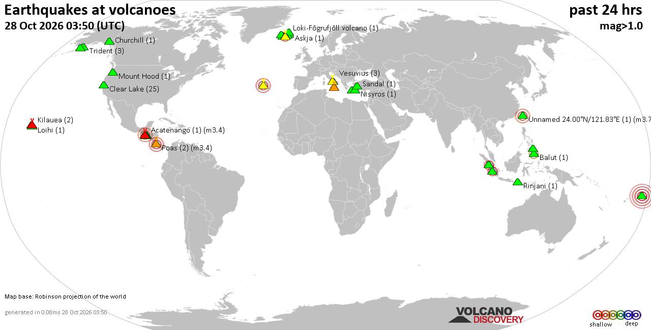
Volcano earthquake report for Wednesday, 28 October 2026
• M 1.5 - 41 km S of South Van Horn, Alaska
• M 4.0 - 10 km N of Lake Pillsbury, CA
• M 2.3 - 49 km W of Nanwalek, Alaska
• M 1.6 - 7 km ENE of Adak, Alaska
• M 1.3 - 59 km ESE of McCarthy, Alaska
|

#931358
Mon 26 Oct 2026 11:50:AM
|
Joined: Feb 2001
Posts: 678,977
Launch Director
|
|
Launch Director
Joined: Feb 2001
Posts: 678,977 |
Volcano earthquake report for Monday, 26 October 2026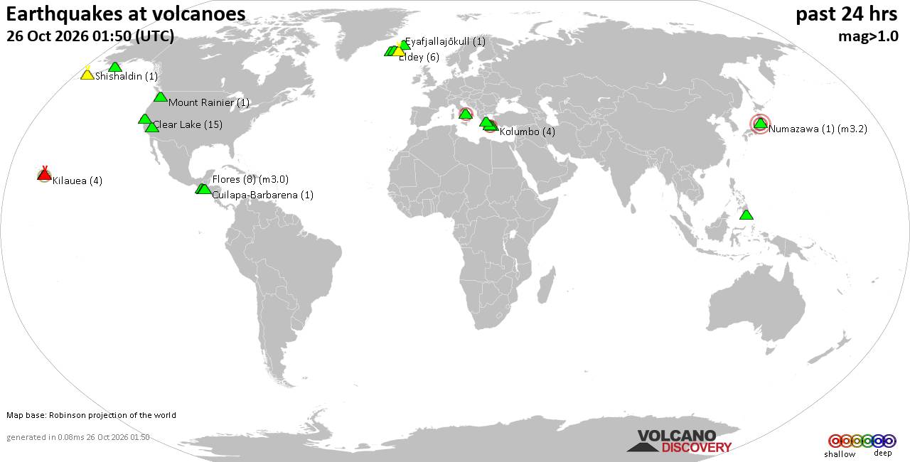 World map showing volcanoes with shallow (less than 50 km) earthquakes within 20 km radius during the past 24 hours on 26 Oct 2026 Number in brackets indicate nr of quakes. Quakes detected near: Agua (1 quake mag 1.5), Alaska Peninsula Arc at 155.4°W (2 quakes between mag 0.9-1.6), Balut (4 quakes between mag 1.6-2.0), Campi Flegrei (Phlegrean Fields) (10 quakes between mag 0.1-3.4), Churchill (1 quake mag 1.3), Clear Lake (13 quakes between mag 0.4-2.1)
Coso (5 quakes between mag 0.5-1.0), Eldey (8 quakes between mag 0.8-1.7), Eyafjallajökull (1 quake mag 1.5), Flores (5 quakes between mag 1.1-2.5), Hrómundartindur (3 quakes between mag 0.4-1.0), Katla (3 quakes between mag 0.0-1.1), Kilauea (4 quakes between mag 2.0-2.3), Kolumbo (1 quake mag 1.4), Koruhüyüğü (1 quake mag 1.9), Laacher See (1 quake mag 1.1), Martin (4 quakes between mag 0.7-1.0), Mayotte Island (1 quake mag 2.0), Milos (1 quake mag 2.2), Mount Rainier (1 quake mag 1.9), Numazawa (1 quake mag 3.2), Sousaki (1 quake mag 1.1), Tjörnes Fracture Zone (2 quakes between mag 1.0-1.5) (updated 11h50)\n\nNote: Earthquakes within 20 km from and at depths less than 50 km under active volcanoes are reported. The list is not complete because many volcanoes are not monitored and/or seismic data in high resolution is not available publicly.\n
Volcanoes with recent earthquakes above magnitude 2 or more than 10 quakes are listed below:
Campi Flegrei (Phlegrean Fields) volcano (Italy): 10 earthquakes up to magnitude 3.410 earthquakes occurred near (under) the volcano during 22 hours, the last being recorded quake 1 hour 1 minutes ago. Hypocenter depths ranged between 10.00 and 1.00 km. Earthquake details: (only 5 largest) Unconfirmed quake or seismic-like event reported: 12 km west of Naples, Napoli, Campania, Italy, Oct 26, 2026 11:42 am (GMT +1) (1 km W) 1.2 quake 4 km southeast of Pozzuoli, Napoli, Campania, Italy, Oct 26, 2026 11:07 am (GMT +1) (0 km NNW) 0.6 quake 4 km southeast of Pozzuoli, Napoli, Campania, Italy, Oct 26, 2026 10:39 am (Universal Time) (0 km SW) 0.1 quake 11 km west of Naples, Napoli, Campania, Italy, Oct 26, 2026 10:49 am (Universal Time) (0 km SSE) 0.1 quake 3 km southeast of Pozzuoli, Napoli, Campania, Italy, Oct 26, 2026 10:44 am (Universal Time) (3 km WSW) All earthquakes at Campi Flegrei (Phlegrean Fields)Campi Flegrei is a 13-km-wide volcanic caldera encompassing part of Naples and the Gulf of Pozzuoli. Its last known eruption formed the Monte Nuovo cone in 1538. Clear Lake volcano (California): 13 earthquakes up to magnitude 2.1Possible earthquake swarm: 13 earthquakes occurred near (under) the volcano during 20 hours, the last being recorded quake 2 hours ago. Hypocenter depths ranged between 2.84 and 1.56 km. Earthquake details: (only 5 largest) 2.1 quake Sonoma County, 13 mi southwest of Clearlake, Lake County, California, United States, Oct 25, 2026 07:06 am (GMT -7) (15 km SSW) 1.7 quake Sonoma County, 15 mi southwest of Clearlake, Lake County, California, United States, Oct 25, 2026 07:36 am (GMT -7) (17 km SSW) 1.4 quake Lake County, 27 mi north of Santa Rosa, Sonoma County, California, United States, Oct 25, 2026 04:02 pm (GMT -7) (16 km S) 1.3 quake 26 mi north of Santa Rosa, Sonoma County, California, United States, Oct 26, 2026 01:43 am (GMT -7) (18 km S) 1.3 quake Lake County, 28 mi north of Santa Rosa, Sonoma County, California, United States, Oct 25, 2026 07:00 pm (GMT -7) (15 km S) All earthquakes at Clear LakeFlores volcano (Guatemala): 5 earthquakes up to magnitude 2.55 earthquakes occurred near (under) the volcano during 13 hours, the last being recorded quake 9 hours ago. Hypocenter depths ranged between 4.80 and 1.60 km. Earthquake details: 2.5 quake 24 km northeast of Cuilapa, Departamento de Santa Rosa, Guatemala, Oct 25, 2026 07:31 am (GMT -6) (14 km WNW) 1.9 quake 22 km northeast of Cuilapa, Departamento de Santa Rosa, Guatemala, Oct 25, 2026 04:35 pm (GMT -6) (14 km WNW) 1.4 quake 21 km northeast of Cuilapa, Departamento de Santa Rosa, Guatemala, Oct 25, 2026 04:40 pm (GMT -6) (15 km WNW) 1.2 quake 23 km northeast of Cuilapa, Departamento de Santa Rosa, Guatemala, Oct 25, 2026 08:24 pm (GMT -6) (15 km WNW) 1.1 quake 22 km northeast of Cuilapa, Departamento de Santa Rosa, Guatemala, Oct 25, 2026 07:44 pm (GMT -6) (15 km WNW) All earthquakes at FloresFlores, also known as Volcán Amayo, is a volcanic field about 10 km west of Jutiapa in southeastern Guatemala. Its last eruption is undated, and none are known from approximately the past 11,700 years. Kilauea volcano (Hawai'i (Big Island)): 4 earthquakes up to magnitude 2.34 earthquakes occurred near (under) the volcano during 8 hours, the last being recorded quake 11 hours ago. Hypocenter depths ranged between 29.26 and 0.87 km. Earthquake details: 2.3 quake 28 mi south of Hilo, Hawaii County, Hawaii, United States, Oct 25, 2026 02:25 pm (GMT -10) (14 km SE) 2.1 quake 12 mi southwest of Volcano, Hawaii County, Hawaii, United States, Oct 25, 2026 07:44 am (GMT -10) (14 km SSW) 2.0 quake 35 mi southwest of Hilo, Hawaii County, Hawaii, United States, Oct 25, 2026 03:17 pm (GMT -10) (16 km SSW) 2.0 quake 27 mi south of Hilo, Hawaii County, Hawaii, United States, Oct 25, 2026 02:47 pm (GMT -10) (9 km SE) All earthquakes at KilaueaMilos volcano (Greece): magnitude 2.2 earthquakeA magnitude 2.2 earthquake occurred at the volcano 16 hours ago. The quake, which might be volcanic in origin, was located at a depth of 10.00 km depth at 18 km distance SSE from the volcano. Earthquake details: 2.2 quake Aegean Sea, 16 km southeast of Milos Island, Greece, Oct 25, 2026 09:59 pm (GMT +2) (18 km SSE) All earthquakes at MilosNumazawa volcano (Honshu): magnitude 3.2 earthquakeA magnitude 3.2 earthquake occurred at the volcano 14 hours ago. The quake, which might be volcanic in origin, was located at a depth of 0 km depth at 15 km distance WSW from the volcano. Earthquake details: 3.2 quake 49 km west of Aizu-Wakamatsu, Fukushima, Japan, Oct 26, 2026 06:46 am (GMT +9) (15 km WSW) All earthquakes at NumazawaNumazawa is a Japanese shield volcano with a 1.5 × 2 km lake-filled caldera. Its only listed confirmed eruptive period was a major explosive and effusive event several thousand years ago. https://www.volcanodiscovery.com/earthquakes-volcanoes/news/388658/Volcano-earthquake-report-2026-10-26.html
|
|



CMS The Best Conveyancing solicitors conveyancing quotes throughout the UK
For any webhosting enquiries please email webmaster@aus-city.com
|
|
Forums60
Topics899,385
Posts934,182
Members2,960
| |
Most Online102,106
Jul 10th, 2026
|
|
|
|
|

|









































