|
|
|
0 members (),
1,356
guests, and
28
robots. |
|
Key:
Admin,
Global Mod,
Mod
|
|
S |
M |
T |
W |
T |
F |
S |
|
|
|
|
|
1
|
2
|
3
|
|
4
|
5
|
6
|
7
|
8
|
9
|
10
|
|
11
|
12
|
13
|
14
|
15
|
16
|
17
|
|
18
|
19
|
20
|
21
|
22
|
23
|
24
|
|
25
|
26
|
27
|
28
|
29
|
30
|
31
|
|
There are no members with birthdays on this day. |
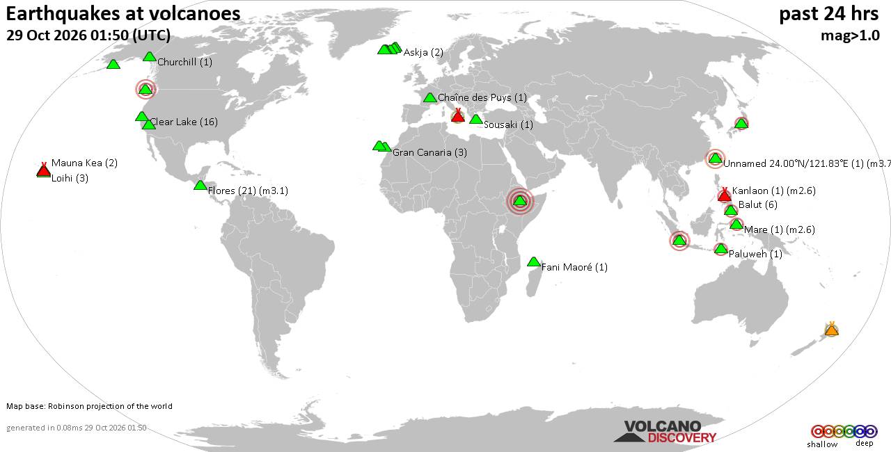
Volcano earthquake report for Thursday, 29 October 2026
• M 1.9 - 5 km WSW of Burning Man Earth, Nevada
• M 2.1 - 2 km E of Mountain Home, Arkansas
• M 2.5 - 95 km S of Sand Point, Alaska
• M 5.5 - 5 km ESE of Asahi, Japan
• M 5.0 - 43 km NNE of Semporna, Malaysia
|

#933396
Tue 27 Oct 2026 01:50:PM
|
Joined: Feb 2001
Posts: 678,977
Launch Director
|
|
Launch Director
Joined: Feb 2001
Posts: 678,977 |
Volcano earthquake report for Tuesday, 27 October 2026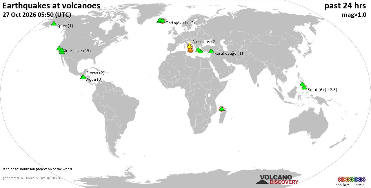 World map showing volcanoes with shallow (less than 50 km) earthquakes within 20 km radius during the past 24 hours on 27 Oct 2026 Number in brackets indicate nr of quakes. Quakes detected near: Acatenango (1 quake mag 3.4), Agua (2 quakes between mag 1.3-1.8), Askja (3 quakes between mag 0.3-1.2), Balut (5 quakes between mag 1.3-2.6), Churchill (1 quake mag 1.1), Clear Lake (21 quakes between mag 0.3-1.5)
Etna (3 quakes between mag 1.3-2.0), Flores (1 quake mag 1.5), Fuego (1 quake mag 2.6), Kalatungan (1 quake mag 1.5), Kolumbo (2 quakes between mag 1.5-2.1), Ljósufjöll (15 quakes between mag 0.1-1.4), Loki-Fögrufjöll volcano (1 quake mag 1.0), Malindang (1 quake mag 1.5), Mammoth Mountain (2 quakes between mag 1.1-1.2), Nisyros (1 quake mag 2.1), Niua (1 quake mag 5.0), Poas (1 quake mag 1.3), Sandal (1 quake mag 1.0), Sousaki (2 quakes between mag 1.1-1.6), Spurr (1 quake mag 1.0), Tjörnes Fracture Zone (2 quakes between mag 0.9-1.2), Torfajökull (15 quakes between mag 0.3-2.2), Trident (2 quakes between mag 0.5-1.0), Vesuvius (3 quakes between mag 0.1-2.0) (updated 13h50)\n\nNote: Earthquakes within 20 km from and at depths less than 50 km under active volcanoes are reported. The list is not complete because many volcanoes are not monitored and/or seismic data in high resolution is not available publicly.\n
Volcanoes with recent earthquakes above magnitude 2 or more than 10 quakes are listed below:
Acatenango volcano (Guatemala): magnitude 3.4 earthquakeA magnitude 3.4 earthquake occurred at the volcano 8 hours ago. The quake, which might be volcanic in origin, was located at a depth of 24.80 km depth at 19 km distance N from the volcano. Earthquake details: 3.4 quake 8.2 km west of Chimaltenango, Departamento de Chimaltenango, Guatemala, Oct 27, 2026 12:01 am (GMT -6) (19 km N) All earthquakes at AcatenangoAcatenango is a 3,976 m stratovolcano near Antigua, Guatemala, and immediately north of Fuego. Its first well-documented eruptions occurred in 1924–27, and its last known eruption was in 1972. Balut volcano (Mindanao): 5 earthquakes up to magnitude 2.65 earthquakes occurred near (under) the volcano during 21 hours, the last being recorded quake 56 minutes ago. Hypocenter depths ranged between 44.00 and 3.00 km. Earthquake details: 2.6 quake Philippine Sea, 13 km northwest of Sarangani Island, Philippines, Oct 27, 2026 07:35 am (GMT +8) (10 km N) 2.2 quake Philippine Sea, 17 km west of Sarangani Island, Philippines, Oct 27, 2026 12:00 am (GMT +8) (11 km NNW) 2.1 quake Celebes Sea, 29 km west of Sarangani, Davao Occidental, Davao, Philippines, Oct 27, 2026 01:18 am (GMT +8) (19 km WSW) 2.0 quake Celebes Sea, 23 km west of Sarangani Island, Philippines, Oct 27, 2026 08:54 pm (GMT +8) (12 km W) 1.3 quake Philippine Sea, 15 km northwest of Sarangani Island, Philippines, Oct 27, 2026 04:29 am (GMT +8) (13 km N) All earthquakes at BalutBalut is an 840 m island stratovolcano south of Mindanao whose last known eruption occurred between about 2 million and 11,700 years ago. Hot springs and thermally altered ground occur on its western and southwestern flanks. Clear Lake volcano (California): 21 earthquakes up to magnitude 1.5Possible earthquake swarm: 21 earthquakes occurred near (under) the volcano during 22 hours, the last being recorded quake 1 hour 19 minutes ago. Hypocenter depths ranged between 3.49 and 0.37 km. Earthquake details: (only 5 largest) 1.5 quake 12 mi southwest of Clearlake, Lake County, California, United States, Oct 27, 2026 05:31 am (GMT -7) (15 km S) 1.3 quake 27 mi north of Santa Rosa, Sonoma County, California, United States, Oct 27, 2026 01:10 am (GMT -7) (18 km SSW) 1.3 quake Lake County, 26 mi north of Santa Rosa, Sonoma County, California, United States, Oct 26, 2026 10:44 am (GMT -7) (17 km S) 1.3 quake 27 mi north of Santa Rosa, Sonoma County, California, United States, Oct 26, 2026 07:42 am (GMT -7) (16 km S) 1.1 quake 28 mi north of Santa Rosa, Sonoma County, California, United States, Oct 27, 2026 03:23 am (GMT -7) (17 km SSW) All earthquakes at Clear LakeFuego volcano (Guatemala): magnitude 2.6 earthquakeA magnitude 2.6 earthquake occurred at the volcano 7 hours ago. The quake, which might be volcanic in origin, was located at a depth of 6.90 km depth at 11 km distance SW from the volcano. Earthquake details: 2.6 quake Departamento de Chimaltenango, 10.4 km northeast of Santa Lucia Cotzumalguapa, Guatemala, Oct 27, 2026 12:25 am (GMT -6) (11 km SW) All earthquakes at FuegoFuego is a highly active Guatemalan stratovolcano near Antigua, with recorded eruptions since the 1500s. Its continuing eruption has produced frequent explosions, ashfall, lava flows, pyroclastic flows and lahars, including the deadly 3 June 2018 disaster. Kolumbo volcano (Greece): 2 earthquakes up to magnitude 2.12 earthquakes occurred near (under) the volcano during 7 hours, the last being recorded quake 7 hours ago. Hypocenter depths ranged between 15.30 and 13.70 km. Earthquake details: 2.1 quake Aegean Sea, 27 km southeast of Nisi Irakleia Island, Greece, Oct 27, 2026 09:05 am (GMT +2) (19 km NE) 1.5 quake Aegean Sea, 27 km northeast of Santorini Island, Greece, Oct 27, 2026 02:10 am (GMT +2) (15 km NE) All earthquakes at KolumboLjósufjöll volcano (Iceland): 15 earthquakes up to magnitude 1.4Possible earthquake swarm: 15 earthquakes occurred near (under) the volcano during 19 hours, the last being recorded quake 2 hours ago. Hypocenter depths ranged between 19.90 and 0.00 km. Earthquake details: (only 5 largest) 1.4 quake 29.0 km N of Borgarnes Oct 27, 2026 06:33 am (Universal Time) (15 km ESE) 1.1 quake 28.5 km N of Borgarnes Oct 27, 2026 04:45 am (Universal Time) (16 km ESE) 0.9 quake Iceland: 19.3 km NNW of Borgarnes Oct 26, 2026 04:08 pm (Reykjavik time) (19 km SSE) 0.7 quake Iceland: 27.0 km N of Borgarnes Oct 27, 2026 11:16 am (Reykjavik time) (15 km ESE) 0.7 quake Iceland: 28.3 km N of Borgarnes Oct 26, 2026 04:09 pm (Reykjavik time) (16 km ESE) All earthquakes at LjósufjöllLjósufjöll is an Icelandic volcanic field with evidence of repeated activity during the past 10,000 years. Its last known eruption occurred around 960 CE and combined explosive activity with lava production. Nisyros volcano (Greece): magnitude 2.1 earthquakeA magnitude 2.1 earthquake occurred at the volcano 8 hours ago. The quake, which might be volcanic in origin, was located at a depth of 16.80 km depth at 16 km distance S from the volcano. Earthquake details: 2.1 quake Aegean Sea, 16 km south of Nisi Nisyros Island, Dodecanese, South Aegean, Greece, Oct 27, 2026 07:40 am (GMT +2) (16 km S) All earthquakes at NisyrosNisyros is a volcanic island in Greece with a 3–4 km caldera, lava domes and vigorous hydrothermal activity. Four confirmed eruptive periods occurred from 1422 to 1888, followed by documented unrest that prompted a crater closure in January 2003. Niua volcano (Tonga): magnitude 5.0 earthquakeA magnitude 5.0 earthquake occurred at the volcano 5 hours ago. The quake, which might be volcanic in origin, was located at a depth of 10.00 km depth at 16 km distance ESE from the volcano. Earthquake details: 5.0 quake South Pacific Ocean, 231 km southwest of Apia, Tuamasaga, Samoa, Oct 27, 2026 10:07 pm (GMT +13) (16 km ESE) All earthquakes at NiuaNiua is a large, irregular submarine volcanic complex in Tonga. Its last known eruption occurred more than approximately 11,700 years ago. Torfajökull volcano (Iceland): 15 earthquakes up to magnitude 2.2Possible earthquake swarm: 15 earthquakes occurred near (under) the volcano during 1 hour 43 minutes, the last being recorded quake 10 hours ago. Hypocenter depths ranged between 4.00 and 0.00 km. Earthquake details: (only 5 largest) 2.2 quake 6.3 km N of Álftavatn Oct 27, 2026 03:54 am (Universal Time) (3 km SSW) 1.6 quake 9.5 km WSW of Landmannalaugar Oct 27, 2026 02:15 am (Universal Time) (4 km NW) 1.0 quake 9.3 km WSW of Landmannalaugar Oct 27, 2026 03:07 am (Universal Time) (4 km NW) 0.8 quake 5.0 km SSW of Landmannalaugar Oct 27, 2026 03:03 am (Universal Time) (4 km ENE) 0.8 quake 9.6 km N of Álftavatn Oct 27, 2026 02:14 am (Universal Time) (3 km WNW) All earthquakes at TorfajökullTorfajökull contains Iceland’s largest exposed area of silicic and intermediate volcanism. Ten recorded eruptive periods span about 8,000 years, with the last known eruption in 1477. https://www.volcanodiscovery.com/earthquakes-volcanoes/news/390017/Volcano-earthquake-report-2026-10-27.html
|
|



CMS The Best Conveyancing solicitors conveyancing quotes throughout the UK
For any webhosting enquiries please email webmaster@aus-city.com
|
|
Forums60
Topics900,683
Posts935,480
Members2,960
| |
Most Online102,106
Jul 10th, 2026
|
|
|
|
|

|









































