|
|
|
0 members (),
2,071
guests, and
25
robots. |
|
Key:
Admin,
Global Mod,
Mod
|
|
S |
M |
T |
W |
T |
F |
S |
|
|
|
|
|
1
|
2
|
3
|
|
4
|
5
|
6
|
7
|
8
|
9
|
10
|
|
11
|
12
|
13
|
14
|
15
|
16
|
17
|
|
18
|
19
|
20
|
21
|
22
|
23
|
24
|
|
25
|
26
|
27
|
28
|
29
|
30
|
31
|
|
There are no members with birthdays on this day. |
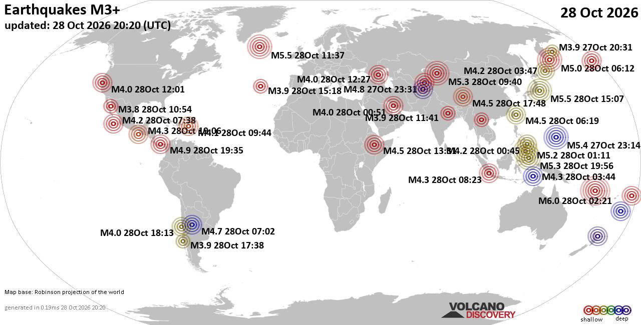
World Earthquake Report for Wednesday, 28 October 2026
• M 1.5 - 41 km S of South Van Horn, Alaska
• M 4.0 - 10 km N of Lake Pillsbury, CA
• M 2.3 - 49 km W of Nanwalek, Alaska
• M 1.6 - 7 km ENE of Adak, Alaska
• M 1.3 - 59 km ESE of McCarthy, Alaska
• M 1.2 - 3 km SW of Redlands, CA
|
|
|
Joined: Feb 2001
Posts: 678,977
Launch Director
|
|
Launch Director
Joined: Feb 2001
Posts: 678,977 |
SPC Oct 28, 2026 1730 UTC Day 2 Convective OutlookSPC 1730Z Day 2 Outlook 
Day 2 Convective Outlook
NWS Storm Prediction Center Norman OK
1220 PM CDT Wed Oct 28 2026

Valid 291200Z - 301200Z

...NO SEVERE THUNDERSTORM AREAS FORECAST...

...SUMMARY...
Severe thunderstorms are not expected on Thursday.

...Synopsis...
Some suppression of upper-level ridging can be expected across the
southern Plains as a shortwave trough moves out of the
Southwest/northern Mexico. Within the northern Rockies, the
upper-level ridge will amplify ahead of a Northwest upper trough.
Modest mid-level height rises will also extend into the central
Plains. A cold front will progress through the lower Great Lakes
region and parts of the Ohio Valley. Southerly flow at low levels
will persist in the southern/central Plains. A modest warm front may
make northward progress within the lower Missouri Valley region late
Thursday into Friday morning.

Convection is likely within the Southwest as the shortwave trough
evolves and moves northeastward. Storms will increase in coverage
northeastward as low-level warm advection develops during the
evening/overnight. Weak lapse rates, modest buoyancy, and weak shear
should minimize severe potential with this activity. Additional
thunderstorms are expected within the lower Missouri Valley late
Thursday into Friday morning. Shear will be slightly stronger than
areas to the southwest. Even so, mid-level lapse rates and elevated
buoyancy will be marginal. Small hail is possible with the strongest
storms, but severe potential still appears low.

..Wendt.. 10/28/2026
Read morehttps://www.spc.noaa.gov/products/outlook/day2otlk_1730.html
|
|



CMS The Best Conveyancing solicitors conveyancing quotes throughout the UK
For any webhosting enquiries please email webmaster@aus-city.com
|
|
Forums60
Topics899,352
Posts934,149
Members2,960
| |
Most Online102,106
Jul 10th, 2026
|
|
|
|
|

|









































