|
|
|
1 members (Webmaster),
1,832
guests, and
32
robots. |
|
Key:
Admin,
Global Mod,
Mod
|
|
S |
M |
T |
W |
T |
F |
S |
|
|
|
|
|
1
|
2
|
3
|
|
4
|
5
|
6
|
7
|
8
|
9
|
10
|
|
11
|
12
|
13
|
14
|
15
|
16
|
17
|
|
18
|
19
|
20
|
21
|
22
|
23
|
24
|
|
25
|
26
|
27
|
28
|
29
|
30
|
31
|
|
There are no members with birthdays on this day. |
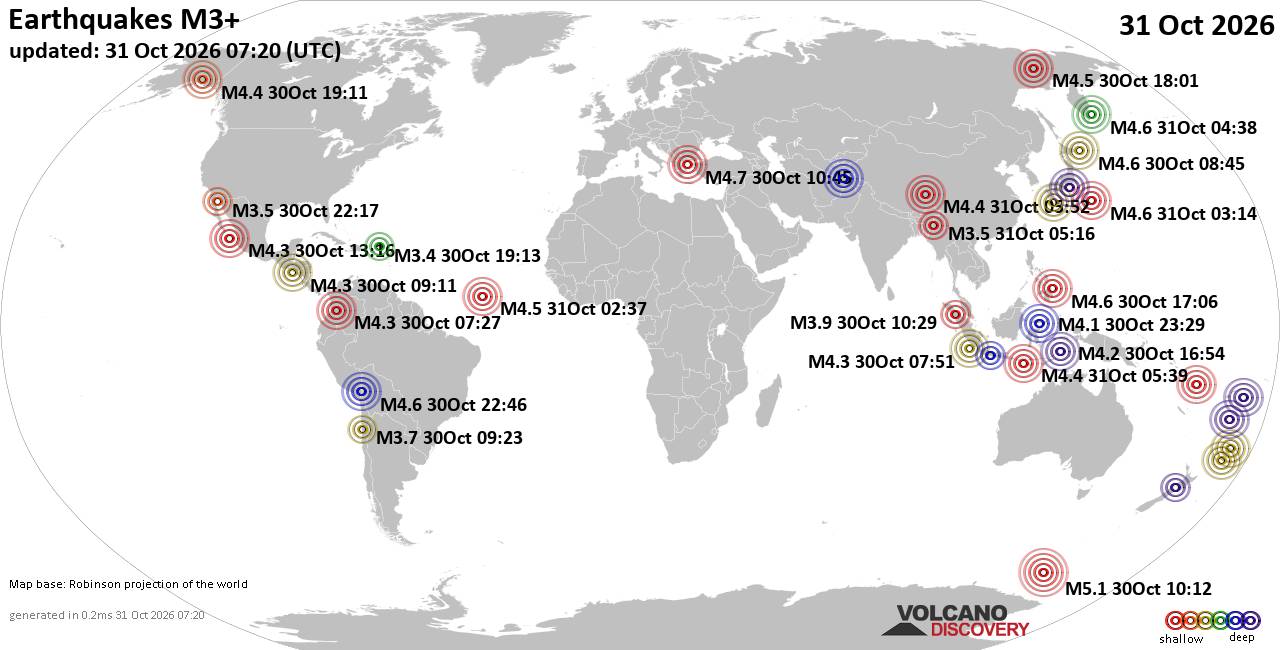
World Earthquake Report for Saturday, 31 October 2026
• M 4.2 - 227 km ENE of Nagqu, China
• M 2.7 - 95 km S of Sand Point, Alaska
• M 4.5 - Balleny Islands region
• M -0.1 - 4 km WSW of Anza, CA
• M 1.3 - 14 km WSW of Lake Nacimiento, CA
|
|
|
Joined: Feb 2001
Posts: 678,977
Launch Director
|
|
Launch Director
Joined: Feb 2001
Posts: 678,977 |
SPC Oct 31, 2026 0730 UTC Day 3 Severe Thunderstorm OutlookSPC 0730Z Day 3 Outlook 
Day 3 Convective Outlook
NWS Storm Prediction Center Norman OK
0227 AM CDT Sat Oct 31 2026

Valid 021200Z - 031200Z

...THERE IS A SLIGHT RISK OF SEVERE THUNDERSTORMS OVER PARTS OF
NORTHERN TEXAS...AND FROM WESTERN AND CENTRAL OKLAHOMA INTO
SOUTHEAST KANSAS...

...SUMMARY...
Scattered severe storms may develop across parts of the central to
southern Plains Monday from late afternoon into the evening, with
damaging wind gusts the main threat.

...Discussion...
On Monday, a large upper trough will cross the Rockies and move into
the Plains, with the upper low moving from CO into KS. A leading
wave will move out of the southern High Plains and into OK/KS during
the day, while the secondary and stronger wave moves eastward out of
northern NM.

At the surface, low pressure will be present over the central High
Plains Monday morning, and this will deepen into NE by 00Z. A cold
front will extend southwestward from the low, moving southward
across CO and western KS during the day. Another front/dryline will
extend south across central KS, western OK, and western TX through
00Z, and this boundary will push east overnight as the NM
disturbance proceeds eastward.

While ample deep-layer shear and a broad fetch of 60s F dewpoints
will exist over the central and southern Plains, surface heating
will be limited over much of the area, and likely relegated to the
dryline. Forecast soundings indicate a relatively cool but moist
boundary layer east of the dryline during the day, with a minor
capping inversion above 850 mb which should prevent warm sector
storms away from the dryline/front.

It is therefore anticipated that the severe risk will begin near or
just after 00Z over western OK and perhaps northwest TX, with
increasing storm coverage through the evening as activity spreads
across OK, eastern KS, and parts of northern TX. More isolated
activity will also be possible along the dryline toward the Rio
Grande.

Storms should initiate near the dryline/wind shift where upper 70s F
temperatures are expected, reducing inhibition. Ample turning with
height of the wind fields as well as up to a 50 kt low-level jet
will support storm rotation, whether discrete or forming into a
line. Instability will not be particularly strong, but sufficient to
support wind damage, and perhaps a tornado risk between 00-06Z.

..Jewell.. 10/31/2026
Read morehttps://www.spc.noaa.gov/products/outlook/day3otlk_0730.html
|
|



CMS The Best Conveyancing solicitors conveyancing quotes throughout the UK
For any webhosting enquiries please email webmaster@aus-city.com
|
|
Forums60
Topics903,749
Posts938,546
Members2,960
| |
Most Online102,106
Jul 10th, 2026
|
|
|
|
|

|









































