|
0 members (),
1,765
guests, and
27
robots. |
|
Key:
Admin,
Global Mod,
Mod
|
|
S |
M |
T |
W |
T |
F |
S |
|
1
|
2
|
3
|
4
|
5
|
6
|
7
|
|
8
|
9
|
10
|
11
|
12
|
13
|
14
|
|
15
|
16
|
17
|
18
|
19
|
20
|
21
|
|
22
|
23
|
24
|
25
|
26
|
27
|
28
|
|
29
|
30
|
|
|
|
|
|
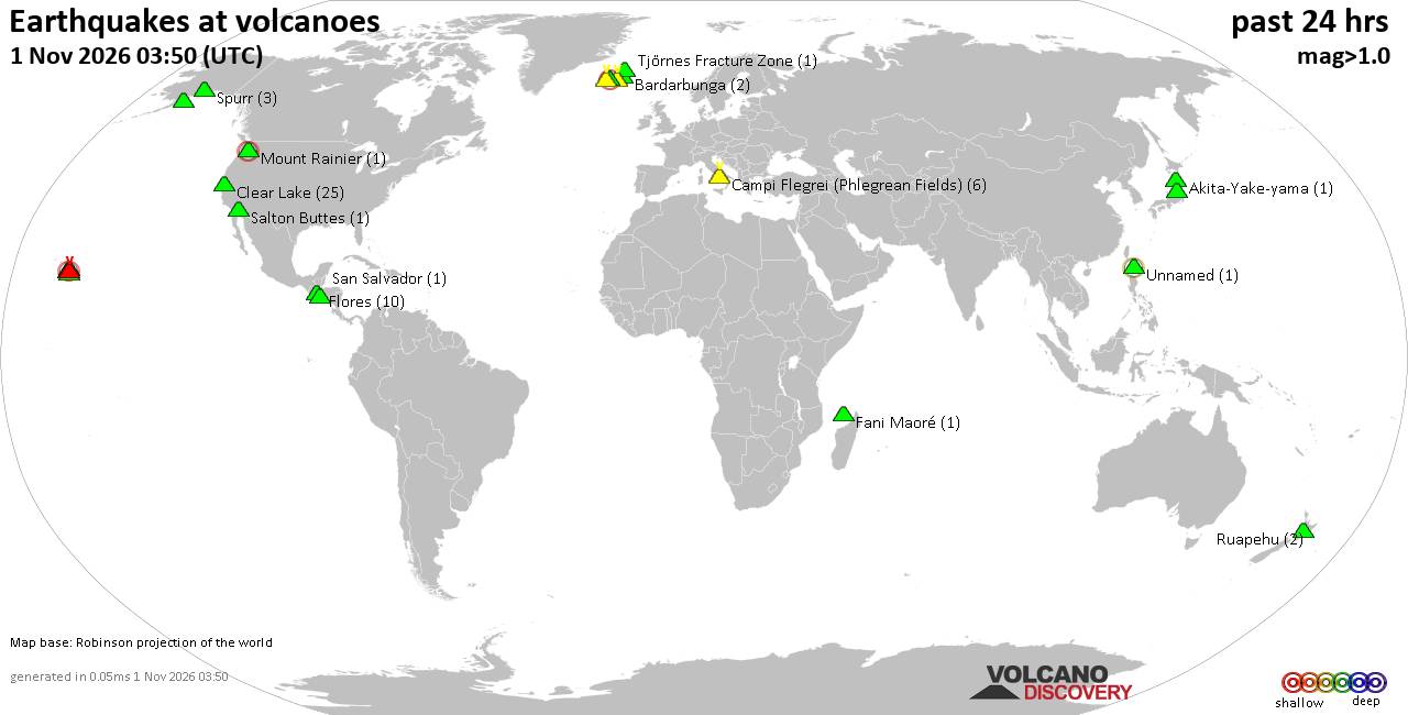
Volcano earthquake report for Sunday, 1 November 2026
• Light mag. 3.9 earthquake - Provincia de El Loa, Region de Antofagasta, Chi...
• M 2.2 - 20 km NNW of Skwentna, Alaska
• M 4.7 - 78 km SSE of Yonakuni, Japan
• M 4.7 - 78 km SSE of Yonakuni, Japan
• M 4.7 - 78 km SSE of Yonakuni, Japan
|
|
|
Joined: Feb 2001
Posts: 678,977
Launch Director
|
|
Launch Director
Joined: Feb 2001
Posts: 678,977 |
SPC Nov 1, 2026 1300 UTC Day 1 Convective OutlookSPC 1300Z Day 1 Outlook 
Day 1 Convective Outlook
NWS Storm Prediction Center Norman OK
0652 AM CST Sun Nov 01 2026

Valid 011300Z - 021200Z

...THERE IS A SLIGHT RISK OF SEVERE THUNDERSTORMS ACROSS PARTS OF
THE SOUTHERN HIGH PLAINS...

...SUMMARY...
Thunderstorms associated with severe wind gusts and a tornado threat
are expected this evening into tonight from parts of New Mexico
northeastward into the southern High Plains. A more isolated severe
threat will be possible in parts of the Desert Southwest this
afternoon.

...Synopsis...
Early-morning satellite imagery shows upper troughing along the West
Coast. Several shortwave troughs are embedded within this troughing,
including two in close proximity in the central/southern CA
vicinity. Mesoscale analysis suggests the southernmost shortwave of
this pair is accompanied by moderate to strong jetlet of
southwesterly flow. Satellite imagery also depicts a broad
baroclinic leaf downstream from these waves, covering much of the
Intermountain West.

Expectation is for the southernmost shortwave to continue quickly
northeastward, reaching the AZ/NM border by this evening and central
KS by 12Z Monday. Strong southwesterly flow aloft will accompany
this wave, spreading across the Four Corners states and southern
High Plains into the southern/central Plains. Strong mass response
is anticipated ahead of the wave across the southern and central
Plains, with dewpoints increasing into the low 60s across eastern
NM. Ascent attendant the wave coupled with this increasing moisture
will support scattered to numerous thunderstorms today, beginning
over southern NV and the Lower CO River Valley vicinity before
spreading eastward across the Southwest and southern/central High
Plains. Modest buoyancy coupled with strong vertical shear will
support the potential for severe thunderstorms within this broader
area of thunderstorms.

...South-Central/Southeast AZ...
Widespread precipitation and cloud cover will inhibit strong heating
across much of AZ today. Even so, increasing low-level moisture
should result in modest buoyancy across southeast AZ ahead of the
lead shortwave trough mentioned in the synopsis. The strong
large-scale forcing for ascent and mid-level flow attendant to this
wave will interact with this modest buoyancy to support more
organized storm structures and the potential for strong,
convectively aided gusts.

Additionally, moderate low-level moisture will remain in place
across south-central AZ after the lead shortwave passes through,
combining with cooling mid-level temperatures to support modest
buoyancy ahead of the second shortwave trough forecast to move
through the region. Shear will remain strong, and a few strong to
severe thunderstorms are possible. Strong gusts will remain the
primary severe risk, but a more cellular storm mode will support an
isolated tornado risk as well.

...Much of NM into the TX Panhandle...
As mentioned in the synopsis, low-level moisture is expected to
advect northward/northwestward from west TX into central/eastern NM
ahead of the approaching shortwave trough. Heating will be tempered
by widespread cloud cover, but the increasing low-level moisture
will still support the development of modest buoyancy as far west as
southwest NM. Ascent attendant to the shortwave will begin
interacting with this instability during the afternoon. Given the
strength of the shear (55 to 65 kt from 0-6 km), quick development
of an organized convective line is anticipated. This line is
forecast to move quickly east-northeastward across central and
eastern NM this evening and overnight before moving into the TX
Panhandle early Monday morning. Strong wind gusts are possible
within this line, particularly with eastern extent as the line
interacts with greater low-level moisture. Greatest potential for
strong gusts appears to be over east-central NM. Isolated gusts over
70 mph are possible.

Additionally, low to mid-level flow is forecast to strengthen across
the southern High Plains this evening and overnight, with low-level
wind profiles becoming supportive of line-embedded tornadoes. The
linear storm mode and likely stable low-levels may somewhat
counteract the favorable wind profiles, but the anomalously moist
and strongly sheared environment still appears supportive of a
seasonally rare overnight tornado risk across the southern High
Plains.

..Mosier/Moore.. 11/01/2026
Read morehttps://www.spc.noaa.gov/products/outlook/day1otlk_1300.html
|
|



CMS The Best Conveyancing solicitors conveyancing quotes throughout the UK
For any webhosting enquiries please email webmaster@aus-city.com
|
|
Forums60
Topics905,422
Posts940,219
Members2,960
| |
Most Online102,106
Jul 10th, 2026
|
|
|









































