|
1 members (Webmaster),
2,249
guests, and
26
robots. |
|
Key:
Admin,
Global Mod,
Mod
|
|
S |
M |
T |
W |
T |
F |
S |
|
1
|
2
|
3
|
4
|
5
|
6
|
7
|
|
8
|
9
|
10
|
11
|
12
|
13
|
14
|
|
15
|
16
|
17
|
18
|
19
|
20
|
21
|
|
22
|
23
|
24
|
25
|
26
|
27
|
28
|
|
29
|
30
|
|
|
|
|
|
|
There are no members with birthdays on this day. |
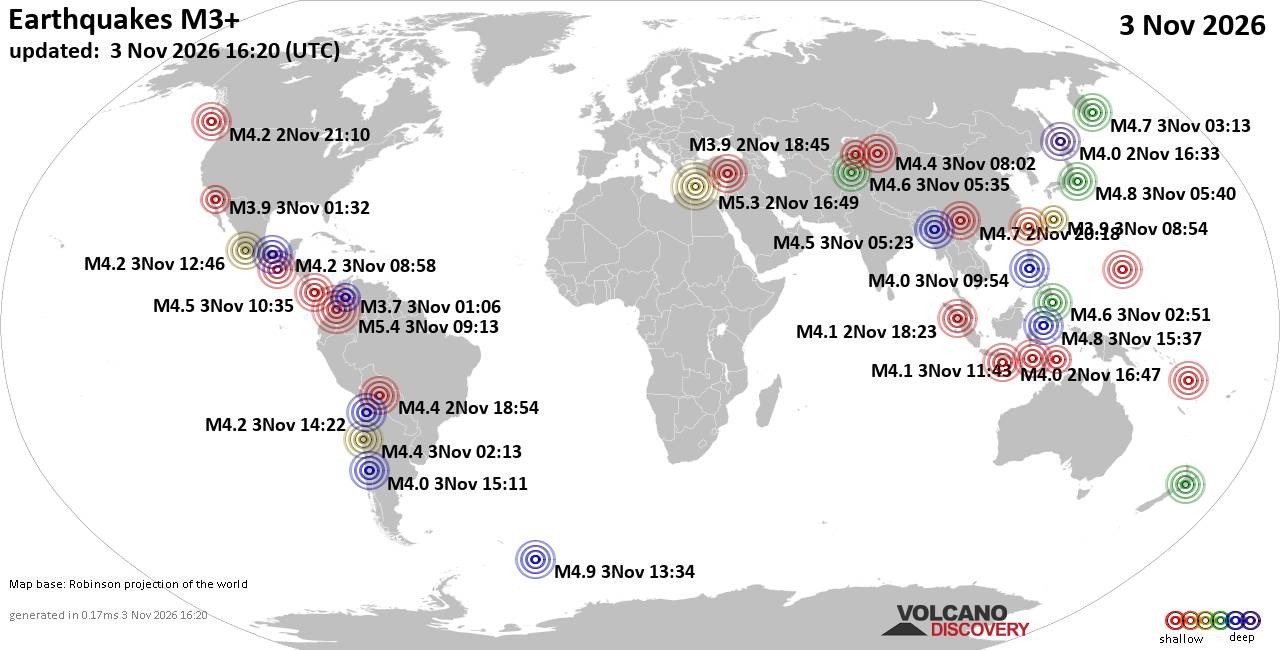
World Earthquake Report for Tuesday, 3 November 2026
• M 1.6 - 6 km NW of Delta, B.C., MX
• M 2.9 - 73 km SE of False Pass, Alaska
• M 1.1 - 15 km NNE of Milford, Utah
• M 1.3 - 18 km SW of Toms Place, CA
• M 5.4 - Mid-Indian Ridge
• M 1.1 - 15 km NNE of Milford, Utah
|
|
|
Joined: Feb 2001
Posts: 678,977
Launch Director
|
|
Launch Director
Joined: Feb 2001
Posts: 678,977 |
SPC Nov 3, 2026 1630 UTC Day 1 Convective OutlookSPC 1630Z Day 1 Outlook 
Day 1 Convective Outlook
NWS Storm Prediction Center Norman OK
1026 AM CST Tue Nov 03 2026

Valid 031630Z - 041200Z

...THERE IS A MARGINAL RISK OF SEVERE THUNDERSTORMS FROM EAST TEXAS
NORTH AND EAST INTO THE LOWER AND MID-MISSISSIPPI VALLEYS...

...SUMMARY...
Thunderstorms with potential for isolated severe wind gusts and
perhaps a brief tornado or two will be possible today from the
Sabine and Lower Mississippi Valleys northward into the Mid
Mississippi Valley.

... Synopsis ...

A midlevel cyclone over the southern Plains this morning will
continue to slowly deepen today as it lifts northeast toward the
upper Midwest. An associated surface cyclone over northeast Kansas
this morning will lift northeast into eastern Iowa during the day
before pivoting north then northwestward overnight as it occludes.
At the same time, an attendant surface baroclinic zone will push
east across the southern Plains today, with an appreciable moist
plume on the east side of the baroclinic zone.

Morning water vapor imagery shows a pronounced shortwave trough
entering the basal region of the longer-wave trough in which the
midlevel cyclone resides. As this shortwave trough exits the basal
region later today, it will take on an increasingly negative tilt
and southerly midlevel flow above the Lower and Mid-Mississippi
valleys will be sustained. In response to the evolving mid- and
upper-level kinematic fields, the low-level jet will be sustained
and move northeast, tied to the progress of the negatively tilted
trough.


... East Texas toward the Lower Mississippi Valley ...

Thunderstorms are ongoing this morning within the broad moist plume
ahead of the aforementioned baroclinic zone. Within this moist
plume, weak midlevel lapse rates and a modest low-level theta-e
airmass has held instability in check today -- generally less than
1000 J/kg. Given low-level moisture trajectories, widespread cloud
cover ahead of the advancing baroclinic zone, and weak lapse rates
upstream of the region, instability should not really recover much
today.

That said, low-level and large-scale forcing for ascent will
continue to support convection through the afternoon and into the
overnight hours. The strength of the kinematic fields will yield
some tornado/wind potential within the various convective bands --
especially where any low-level instability can develop.
Additionally, transient supercell or supercell-like thunderstorms
may develop ahead of the line within the broad warm-air advection
regime. These shallow, but rotating, thunderstorms will also pose at
least some potential for tornado/wind damage as well.

This threat should continue into the overnight hours across portions
of western Tennessee and western Kentucky, especially if a zone of
more discrete showers/thunderstorms can develop within the nocturnal
low-level jet.


... Mid-Mississippi Valley ...

As the surface-low deepens this afternoon and evening, strong
low-level wind fields will be maintained or even strengthen,
yielding ESRH on the order of 250-350 m2/s2. As strong southerly
midlevel flow is sustained in response to the approaching midlevel
shortwave trough, effective-layer shear in excess of 50 knots will
be maintained or overspread much of the region. This far north,
instability will be even more limited than compared to areas farther
south. However, convergence along the surface front and large-scale
ascent from the midlevel wave will support bands of forced
convection during the day and into the evening. The strong kinematic
fields may be sufficient to offset the meager buoyancy and support a
potential for isolated tornado/wind damage.

..Marsh/Supinie.. 11/03/2026
Read morehttps://www.spc.noaa.gov/products/outlook/day1otlk_1630.html
|
|



CMS The Best Conveyancing solicitors conveyancing quotes throughout the UK
For any webhosting enquiries please email webmaster@aus-city.com
|
|
Forums60
Topics909,195
Posts943,992
Members2,960
| |
Most Online102,106
Jul 10th, 2026
|
|
|









































