|
|
|
0 members (),
1,195
guests, and
25
robots. |
|
Key:
Admin,
Global Mod,
Mod
|
|
S |
M |
T |
W |
T |
F |
S |
|
1
|
2
|
3
|
4
|
5
|
6
|
7
|
|
8
|
9
|
10
|
11
|
12
|
13
|
14
|
|
15
|
16
|
17
|
18
|
19
|
20
|
21
|
|
22
|
23
|
24
|
25
|
26
|
27
|
28
|
|
29
|
30
|
|
|
|
|
|
|
There are no members with birthdays on this day. |
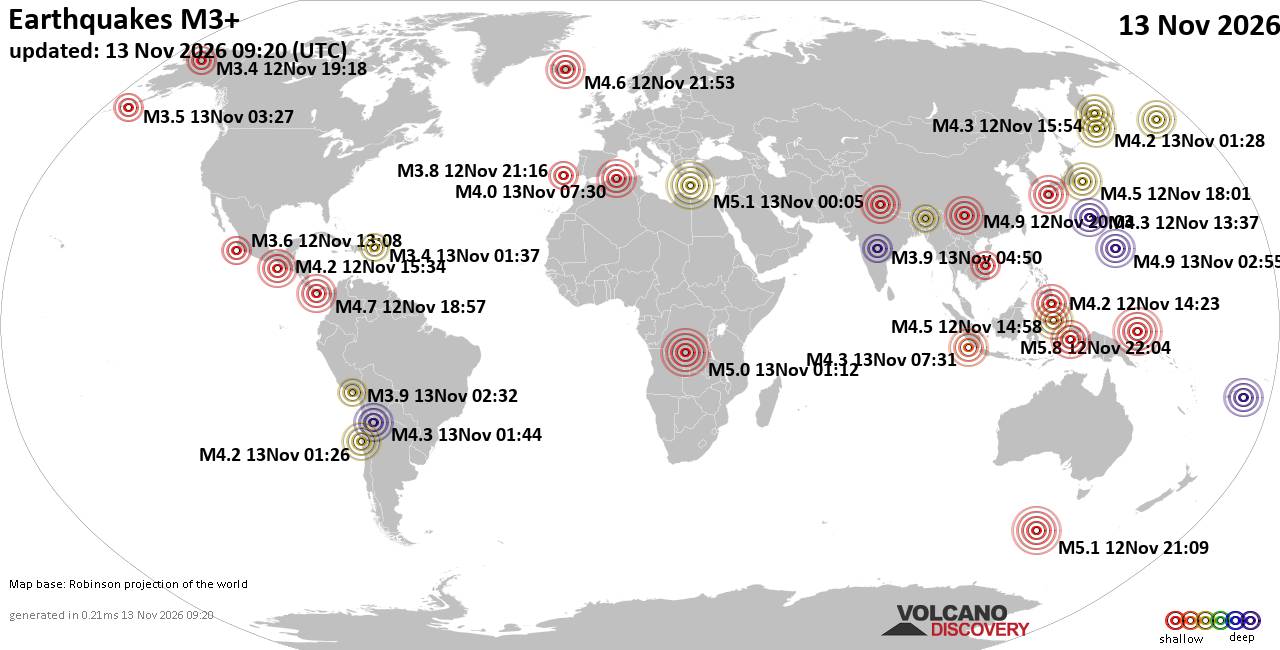
World Earthquake Report for Friday, 13 November 2026
• M 0.5 - 3 km ESE of Pacifica, CA
• M 1.4 - 10 km ESE of Suisun City, CA
• M 1.7 - 6 km NW of The Geysers, CA
• M 2.9 - 133 km SSE of False Pass, Alaska
• M 1.8 - 5 km SE of San Ardo, CA
|

#952241
Sat 07 Nov 2026 06:50:AM
|
Joined: Feb 2001
Posts: 800,656
Launch Director
|
|
Launch Director
Joined: Feb 2001
Posts: 800,656 |
Volcano earthquake report for Saturday, 7 November 2026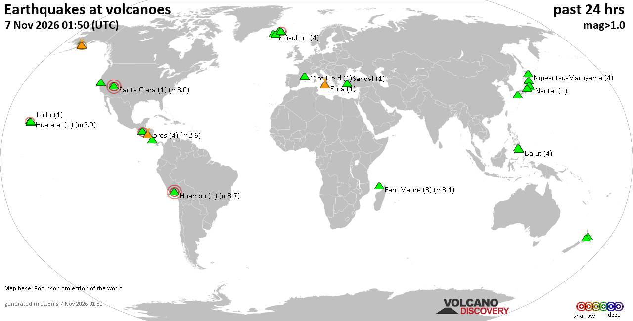 World map showing volcanoes with shallow (less than 50 km) earthquakes within 20 km radius during the past 24 hours on 7 Nov 2026 Number in brackets indicate nr of quakes. Quakes detected near: Abu (2 quakes between mag 0.7-1.6), Akita-Yake-yama (4 quakes between mag 0.6-1.5), Askja (1 quake mag 1.3), Balut (3 quakes between mag 1.7-2.0), Barva (1 quake mag 1.0), Clear Lake (15 quakes between mag 0.2-1.3)
Coso (2 quakes between mag 0.9-1.0), Fani Maoré (1 quake mag 1.6), Flores (2 quakes between mag 2.4-2.6), Fourpeaked (1 quake mag 2.3), Hayes (1 quake mag 1.2), Hiuchi (3 quakes between mag 0.1-1.1), Hualalai (1 quake mag 2.9), Huambo (1 quake mag 3.7), Katmai (2 quakes between mag 0.7-1.1), Kolbeinsey Ridge (1 quake mag 1.4), Kurikoma (2 quakes between mag 0.5-1.1), Ljósufjöll (4 quakes between mag 0.0-1.4), Loihi (1 quake mag 1.7), Maunaloa (2 quakes between mag 1.6-1.9), Nantai (1 quake mag 1.0), Nipesotsu-Maruyama (4 quakes between mag 0.1-1.6), Numazawa (4 quakes between mag 0.7-1.2), Olot Field (1 quake mag 1.5), Ontake-san (3 quakes between mag 0.1-1.3), Parker (1 quake mag 1.5), Prestahnukur (1 quake mag 1.1), Sandal (1 quake mag 1.0), Telica (2 quakes between mag 1.2-1.8), Theistareykjarbunga (1 quake mag 1.2), Tjörnes Fracture Zone (6 quakes between mag 0.0-2.1), Unzen (2 quakes between mag 0.8-1.4) (updated 06h50)\n\nNote: Earthquakes within 20 km from and at depths less than 50 km under active volcanoes are reported. The list is not complete because many volcanoes are not monitored and/or seismic data in high resolution is not available publicly.\n
Volcanoes with recent earthquakes above magnitude 2 or more than 10 quakes are listed below:
Clear Lake volcano (California): 15 earthquakes up to magnitude 1.3Possible earthquake swarm: 15 earthquakes occurred near (under) the volcano during 20 hours, the last being recorded quake 4 hours ago. Hypocenter depths ranged between 13.52 and 1.38 km. Earthquake details: (only 5 largest) 1.3 quake Lake County, 28 mi north of Santa Rosa, Sonoma County, California, United States, Nov 6, 2026 09:47 am (GMT -8) (15 km S) 1.3 quake 27 mi north of Santa Rosa, Sonoma County, California, United States, Nov 6, 2026 09:47 am (GMT -8) (17 km SSW) 1.1 quake Lake County, 27 mi north of Windsor, Sonoma County, California, United States, Nov 6, 2026 10:10 am (GMT -8) (16 km WSW) 1.1 quake Lake County, 28 mi north of Santa Rosa, Sonoma County, California, United States, Nov 6, 2026 09:45 am (GMT -8) (15 km S) 1.0 quake Lake County, 28 mi north of Santa Rosa, Sonoma County, California, United States, Nov 6, 2026 02:51 pm (GMT -8) (15 km S) All earthquakes at Clear LakeFlores volcano (Guatemala): 2 earthquakes up to magnitude 2.62 earthquakes occurred near (under) the volcano during 1 hour 53 minutes, the last being recorded quake 12 hours ago. Hypocenter depths ranged between 5.00 and 5.00 km. Earthquake details: 2.6 quake 24 km west of Jutiapa, Departamento de Jutiapa, Guatemala, Nov 6, 2026 12:33 pm (GMT -6) (13 km WNW) 2.4 quake 24 km northeast of Cuilapa, Departamento de Santa Rosa, Guatemala, Nov 6, 2026 10:41 am (GMT -6) (14 km WNW) All earthquakes at FloresFlores, also known as Volcán Amayo, is a volcanic field about 10 km west of Jutiapa in southeastern Guatemala. Its last eruption is undated, and none are known from approximately the past 11,700 years. Fourpeaked volcano (Alaska Peninsula): magnitude 2.3 earthquakeA magnitude 2.3 earthquake occurred at the volcano 4 hours ago. The quake, which might be volcanic in origin, was located at a depth of 0.80 km depth at 3 km distance NNE from the volcano. Earthquake details: 2.3 quake Kenai Peninsula Borough, 83 mi northwest of Kodiak, Kodiak Island Borough, Alaska, United States, Nov 6, 2026 06:12 pm (GMT -9) (3 km NNE) All earthquakes at FourpeakedFourpeaked is a glacier-covered Alaskan stratovolcano whose first confirmed historical eruption occurred in September 2006. A 1-km-long summit fissure produced a phreatic eruption and minor ashfall, followed by unrest into 2007. Hualalai volcano (Hawai'i (Big Island)): magnitude 2.9 earthquakeA magnitude 2.9 earthquake occurred at the volcano 9 hours ago. The quake, which might be volcanic in origin, was located at a depth of 13.91 km depth at 10 km distance NW from the volcano. Earthquake details: 2.9 quake 3.2 mi northeast of Kalaoa, Hawaii County, Hawaii, United States, Nov 6, 2026 12:08 pm (Honolulu time) (10 km NW) All earthquakes at HualalaiHuambo volcano (Peru): magnitude 3.7 earthquakeA magnitude 3.7 earthquake occurred at the volcano 13 hours ago. The quake, which might be volcanic in origin, was located at a depth of 12.00 km depth at 6 km distance N from the volcano. Earthquake details: 3.7 quake 95 km northwest of Arequipa, Arequipa, Peru, Nov 6, 2026 01:07 pm (Lima time) (6 km N) All earthquakes at HuamboHuambo is a two-part volcanic field in Peru. Its only confirmed dated eruption occurred at Cerro Keyocc around 700 BCE, producing explosive activity, scoria and lava flows. Tjörnes Fracture Zone volcano (Iceland): 6 earthquakes up to magnitude 2.16 earthquakes occurred near (under) the volcano during 11 hours, the last being recorded quake 3 hours ago. Hypocenter depths ranged between 9.60 and 5.10 km. Earthquake details: (only 5 largest) 2.1 quake 11.0 km WNW of Kópasker Nov 6, 2026 04:58 pm (Reykjavik time) (19 km E) 1.7 quake Iceland: 11.7 km WSW of Kópasker Nov 7, 2026 01:39 am (Reykjavik time) (19 km ESE) 1.3 quake Iceland: 14.7 km WSW of Kópasker Nov 7, 2026 04:04 am (Reykjavik time) (18 km ESE) 0.9 quake Iceland: 11.2 km W of Kópasker Nov 7, 2026 03:20 am (Reykjavik time) (19 km E) 0.7 quake Iceland: 10.8 km W of Kópasker Nov 7, 2026 12:50 am (Reykjavik time) (19 km E) All earthquakes at Tjörnes Fracture ZoneThe Tjörnes Fracture Zone is an offshore volcanic system north of Iceland. A poorly documented submarine eruption was reported near Manareyjar Island in 1867–1868. https://www.volcanodiscovery.com/earthquakes-volcanoes/news/403516/Volcano-earthquake-report-2026-11-07.html
|
|



CMS The Best Conveyancing solicitors conveyancing quotes throughout the UK
For any webhosting enquiries please email webmaster@aus-city.com
|
|
Forums60
Topics925,566
Posts960,363
Members2,960
| |
Most Online102,106
Jul 10th, 2026
|
|
|
|
|

|









































