|
1 members (Alisa),
3,724
guests, and
24
robots. |
|
Key:
Admin,
Global Mod,
Mod
|
|
S |
M |
T |
W |
T |
F |
S |
|
1
|
2
|
3
|
4
|
5
|
6
|
7
|
|
8
|
9
|
10
|
11
|
12
|
13
|
14
|
|
15
|
16
|
17
|
18
|
19
|
20
|
21
|
|
22
|
23
|
24
|
25
|
26
|
27
|
28
|
|
29
|
30
|
|
|
|
|
|
|
There are no members with birthdays on this day. |
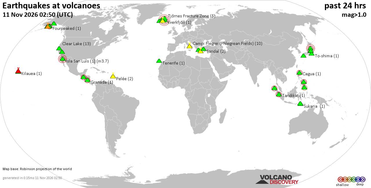
Volcano earthquake report for Wednesday, 11 November 2026
• M 2.5 - 39 km SW of Karluk, Alaska
• M 1.5 - 12 km ESE of Mammoth Lakes, CA
• M 2.2 - 88 km SE of Akutan, Alaska
• M 1.8 - 14 km E of Pearsall, Texas
• M 2.1 - 28 km SSW of Larsen Bay, Alaska
• M 1.6 - 64 km NW of Tatitlek, Alaska
|
|
|
Joined: Feb 2001
Posts: 800,656
Launch Director
|
|
Launch Director
Joined: Feb 2001
Posts: 800,656 |
SPC MD 2449MD 2449 CONCERNING SEVERE POTENTIAL...WATCH POSSIBLE FOR FAR EASTERN ILLINOIS INTO INDIANA AND KENTUCKY 
Mesoscale Discussion 2449
NWS Storm Prediction Center Norman OK
0120 PM CST Wed Nov 11 2026

Areas affected...far eastern Illinois into Indiana and Kentucky

Concerning...Severe potential...Watch possible

Valid 111920Z - 112145Z

Probability of Watch Issuance...40 percent

SUMMARY...Storms will increase from eastern Illinois into Indiana
and into Kentucky through early evening. Areas of hail will be
likely, with isolated damaging gusts possible. A tornado cannot be
ruled out late in the day into early evening.

DISCUSSION...An upper trough will cold temperatures aloft continues
to move southeastward across the MS and OH Valleys, with a deepening
surface low now over central to east-central IL. Surface analysis
indicates up to 2 mb per hour pressure falls ahead of this low.
Meanwhile, daytime heating persists ahead of the low, with a plume
of 50s F dewpoints spreading northeastward out of MO/AR.

While instability is currently minimal, the combination of low-level
moisture advection with cooling temperatures aloft should favor
increasing instability and storm coverage/intensity later this
afternoon. Given such cold temperatures aloft, and expected cellular
storm mode, hail is likely, some over 1.00" diameter. Fast storm
motions and steepening lapse rates will also favor strong wind
gusts.

The tornado threat is non-zero, and dependent on low-level moisture
quality and storm mode. During the late afternoon into the early
evening, there appears to be a corridor of risk from southern IN
into KY, in closer proximity to the higher dewpoints, and as
low-level SRH possibly increases to 200 m2/s2 just ahead of the main
wind shift.

..Jewell/Mosier.. 11/11/2026

...Please see www.spc.noaa.gov for graphic product...

ATTN...WFO...ILN...LMK...IND...PAH...LOT...ILX...

LAT...LON   39618826 39938829 40118837 40408823 40468762 40318659
            40068580 39508528 38898507 38398506 37578571 37138667
            37098745 37188805 37518843 37828852 38128843 38828830
            39618826

MOST PROBABLE PEAK TORNADO INTENSITY...UP TO 90 MPH
MOST PROBABLE PEAK WIND GUST...UP TO 60 MPH
MOST PROBABLE PEAK HAIL SIZE...1.00-1.75 IN
Read morehttps://www.spc.noaa.gov/products/md/md2449.html
|
|



CMS The Best Conveyancing solicitors conveyancing quotes throughout the UK
For any webhosting enquiries please email webmaster@aus-city.com
|
|
Forums60
Topics922,651
Posts957,448
Members2,960
| |
Most Online102,106
Jul 10th, 2026
|
|
|









































