|
1 members (Alisa),
3,724
guests, and
24
robots. |
|
Key:
Admin,
Global Mod,
Mod
|
|
S |
M |
T |
W |
T |
F |
S |
|
1
|
2
|
3
|
4
|
5
|
6
|
7
|
|
8
|
9
|
10
|
11
|
12
|
13
|
14
|
|
15
|
16
|
17
|
18
|
19
|
20
|
21
|
|
22
|
23
|
24
|
25
|
26
|
27
|
28
|
|
29
|
30
|
|
|
|
|
|
|
There are no members with birthdays on this day. |
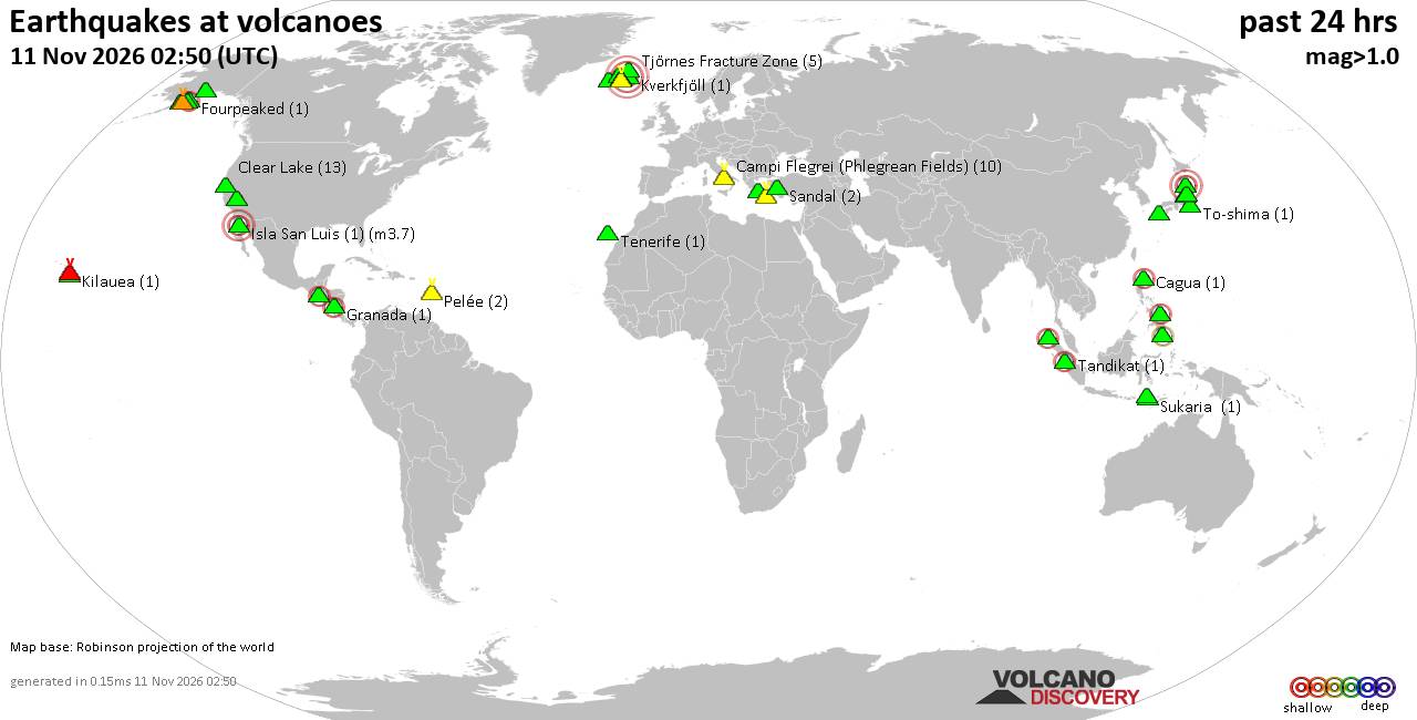
Volcano earthquake report for Wednesday, 11 November 2026
• M 2.5 - 39 km SW of Karluk, Alaska
• M 1.5 - 12 km ESE of Mammoth Lakes, CA
• M 2.2 - 88 km SE of Akutan, Alaska
• M 1.8 - 14 km E of Pearsall, Texas
• M 2.1 - 28 km SSW of Larsen Bay, Alaska
• M 1.6 - 64 km NW of Tatitlek, Alaska
|
|
|
Joined: Feb 2001
Posts: 800,656
Launch Director
|
|
Launch Director
Joined: Feb 2001
Posts: 800,656 |
SPC Nov 11, 2026 2000 UTC Day 1 Convective OutlookSPC 2000Z Day 1 Outlook 
Day 1 Convective Outlook
NWS Storm Prediction Center Norman OK
0200 PM CST Wed Nov 11 2026

Valid 112000Z - 121200Z

...THERE IS A SLIGHT RISK OF SEVERE THUNDERSTORMS ACROSS PARTS OF
CENTRAL/SOUTHERN INDIANA...WESTERN KENTUCKY...AND FAR SOUTHEASTERN
ILLINOIS...

...SUMMARY...
Thunderstorms capable of producing severe hail, damaging winds, and
perhaps a tornado are forecast this afternoon and evening across
parts of eastern Illinois into Indiana, western/central Kentucky,
and middle Tennessee. Isolated severe thunderstorms are also
possible across the east-central Florida Peninsula.

...20Z Update...
A Slight Risk was introduced for parts of central/southern IN,
western KY, and far southeastern IL -- driven by 15-percent hail and
wind probabilities. As lower 50s dewpoints (along/ahead of the cold
front) continue spreading eastward beneath steepening midlevel lapse
rates, a corridor of 500-1000 J/kg MLCAPE should support a gradual
increase in updraft intensity this afternoon into the evening. An
elongated hodograph (around 30-40 kt of effective shear) along with
increasing forcing for ascent should promote a mix of organized
clusters and perhaps supercell structures capable of producing
scattered severe hail (around 1-1.5 inches in diameter) and damaging
wind gusts. See MCD #2449 for more details.

..Weinman.. 11/11/2026

.PREV DISCUSSION... /ISSUED 1030 AM CST Wed Nov 11 2026/

...Midwest/Lower Ohio Valley into Middle Tennessee...
Recent satellite imagery shows a lead shortwave trough moving into
northern IL, with another shortwave trough farther back northwest
moving into the Mid MO Valley. Showers and thunderstorms are ongoing
near the lead shortwave. Thunderstorm intensity has decreased over
the last half hour or so as these storms move into an environment
with less elevated buoyancy (as observed by the 12Z ILX sounding).
The lead shortwave is forecast to continue eastward into the OH
Valley while the second shortwave continues more southeastward into
the Lower OH Valley vicinity. The surface low currently over the
IA/IL border vicinity is forecast to progress eastward with the lead
wave while an attendant cold front sweeps southeastward through the
mid MS Valley/Mid-South, and lower OH Valley this afternoon and
evening.

Increasing low-level moisture is anticipated ahead of this front,
advecting northeastward into the region from the Ozarks/Mid-South
region. Recent surface analysis shows the mid 50s dewpoints are
still in northern AR, so there is some question as to how far
northeastward the greater low-level moisture will reach before
frontal passage. Current expectation is for the best overlap between
low-level moisture (and associated buoyancy) with the stronger
large-scale ascent will occur across southern IN and adjacent
western KY. Here, the combination of weak buoyancy (i.e. MLCAPE
around 500-800 J/kg) and 30-40 kt of deep-layer shear
oriented largely orthogonal to the surface cold front should support
a mix of bowing clusters and supercells. Isolated hail and damaging
gusts will be the primary risks. Hail is more likely with any more
cellular activity and damaging gusts more likely with any
fast-moving bowing segments. Modestly enhanced low-level
shear may also support a low-probability tornado risk, but a
tendency for low-level flow to veer to westerly should reduce
effective SRH with time through the late afternoon/evening. The
isolated severe risk should diminish with eastward extent this
evening across the lower OH Valley as front outruns the low-level
moisture and daytime heating wanes.

...Central/Southern Florida Peninsula...
Isolated to scattered thunderstorms are expected across the
central/southern FL Peninsula this afternoon. Glancing large-scale
ascent associated with a weak mid-level perturbation over the
Southeast should aid this convective development. A warm layer
around 700 mb could limit overall buoyancy, but 500 mb temperatures
will be around -9 to -11 deg C and most forecast sounding still show
1500+ J/kg of uninhibited MLCAPE this afternoon. Moderate deep-layer
shear will exists across the region as well. These conditions appear
supportive of marginally severe hail and gusty winds within the
stronger cores, which appear most probable along the east-central FL
Coast.
Read morehttps://www.spc.noaa.gov/products/outlook/day1otlk_2000.html
|
|



CMS The Best Conveyancing solicitors conveyancing quotes throughout the UK
For any webhosting enquiries please email webmaster@aus-city.com
|
|
Forums60
Topics922,651
Posts957,448
Members2,960
| |
Most Online102,106
Jul 10th, 2026
|
|
|









































