|
|
|
0 members (),
1,505
guests, and
26
robots. |
|
Key:
Admin,
Global Mod,
Mod
|
|
S |
M |
T |
W |
T |
F |
S |
|
1
|
2
|
3
|
4
|
5
|
6
|
7
|
|
8
|
9
|
10
|
11
|
12
|
13
|
14
|
|
15
|
16
|
17
|
18
|
19
|
20
|
21
|
|
22
|
23
|
24
|
25
|
26
|
27
|
28
|
|
29
|
30
|
|
|
|
|
|
|
There are no members with birthdays on this day. |
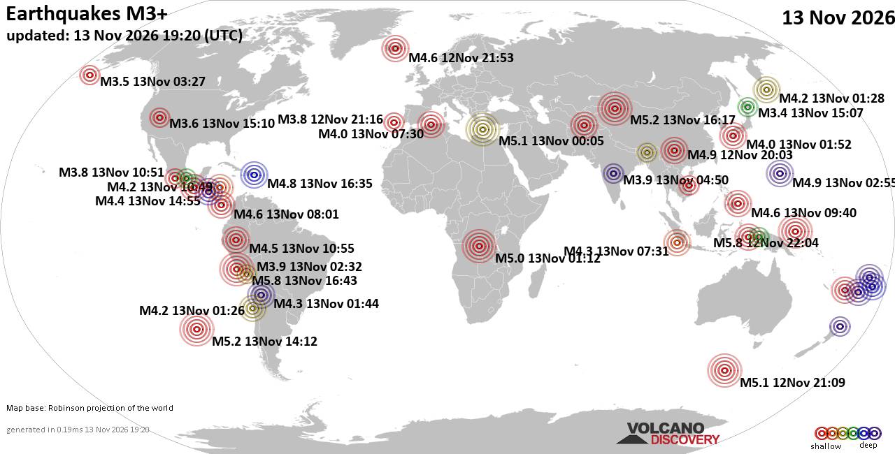
World Earthquake Report for Friday, 13 November 2026
• M 0.5 Other Event - 62 km ENE of Pedro Bay, Alaska
• M 0.5 Other Event - 64 km ENE of Pedro Bay, Alaska
• M 0.4 Other Event - 65 km ENE of Pedro Bay, Alaska
• M 4.5 - Mid-Indian Ridge
• M 0.4 Other Event - 63 km ENE of Pedro Bay, Alaska
• M 1.6 - 89 km NNW of Rachel, Nevada
|
|
|
Joined: Feb 2001
Posts: 800,656
Launch Director
|
|
Launch Director
Joined: Feb 2001
Posts: 800,656 |
Volcano earthquake report for Friday, 13 November 2026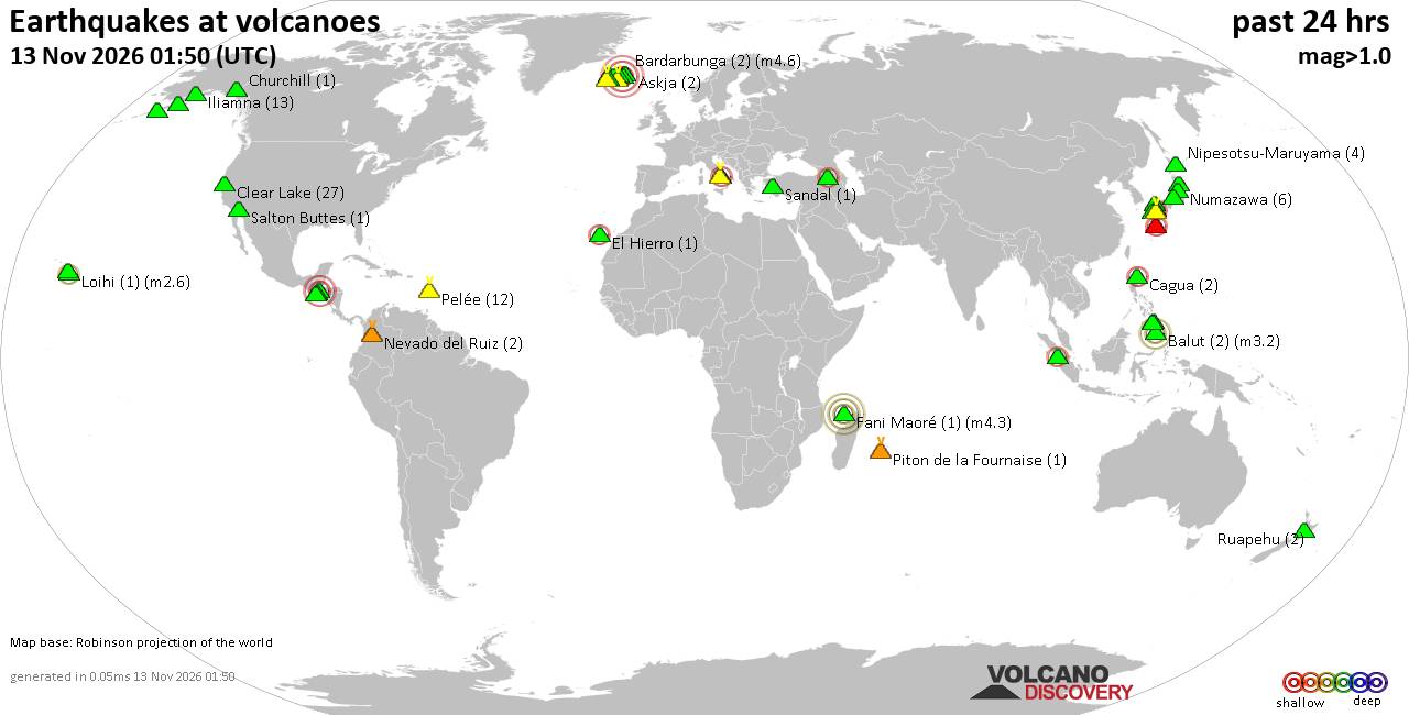 World map showing volcanoes with shallow (less than 50 km) earthquakes within 20 km radius during the past 24 hours on 13 Nov 2026 Number in brackets indicate nr of quakes. Quakes detected near: Abu (11 quakes between mag 0.1-1.3), Akita-Yake-yama (1 quake mag 1.4), Aso (3 quakes between mag 0.1-1.7), Balut (1 quake mag 1.9), Bardarbunga (3 quakes between mag 0.3-4.6), Cagua (2 quakes between mag 1.7-2.4)
Camiguin de Babuyanes (1 quake mag 1.5), Campi Flegrei (Phlegrean Fields) (5 quakes between mag 0.1-2.6), Clear Lake (15 quakes between mag 0.3-1.7), Coso (2 quakes between mag 0.9-1.4), Eldey (12 quakes between mag 0.7-1.9), Gilbanta (1 quake mag 3.3), Grímsnes (4 quakes between mag 0.0-2.2), Grímsvötn (2 quakes between mag 0.7-1.0), Hakone (1 quake mag 1.0), Iliamna (18 quakes between mag 0.2-1.1), Indian Heaven (1 quake mag 1.3), Iwaki (1 quake mag 1.1), Kalatungan (2 quakes between mag 1.6-1.9), Katla (5 quakes between mag 0.2-1.4), Kilauea (2 quakes between mag 1.7-1.8), Kozushima (1 quake mag 1.5), Krísuvík (5 quakes between mag 0.0-1.5), Kurikoma (3 quakes between mag 0.5-1.6), Ljósufjöll (1 quake mag 1.2), Mageik (2 quakes between mag 0.6-1.0), Maunaloa (1 quake mag 2.5), Nikko-Shirane (1 quake mag 1.2), Numazawa (6 quakes between mag 0.7-1.0), Okataina (Tarawera) (1 quake mag 2.0), Ontake-san (5 quakes between mag 0.4-1.4), Paluweh (1 quake mag 3.7), Pelée (8 quakes between mag 0.1-1.2), Sabancaya (1 quake mag 3.5), Salton Buttes (1 quake mag 1.4), Sanbe (5 quakes between mag 0.3-3.5), Tacaná (1 quake mag 2.0), Takahara (15 quakes between mag 0.1-1.7), Talakmau (1 quake mag 2.5), Tecuamburro (1 quake mag 1.9), Tenerife (1 quake mag 1.0), Tindfjallajökull (1 quake mag 2.5), Tjörnes Fracture Zone (1 quake mag 1.6), Tokachi (1 quake mag 1.4), Tsurumi (4 quakes between mag 0.3-1.1) (updated 16h50)\n\nNote: Earthquakes within 20 km from and at depths less than 50 km under active volcanoes are reported. The list is not complete because many volcanoes are not monitored and/or seismic data in high resolution is not available publicly.\n
Volcanoes with recent earthquakes above magnitude 2 or more than 10 quakes are listed below:
Abu volcano (Honshu): 11 earthquakes up to magnitude 1.3Possible earthquake swarm: 11 earthquakes occurred near (under) the volcano during 10 hours, the last being recorded quake 9 hours ago. Hypocenter depths ranged between 17.40 and 13.10 km. Earthquake details: (only 5 largest) 1.3 quake 21 km north of Yamaguchi, Yamaguchi, Japan, Nov 13, 2026 06:25 am (GMT +9) (13 km S) 1.0 quake 33 km north of Yamaguchi, Yamaguchi, Japan, Nov 13, 2026 10:56 am (GMT +9) (7 km ESE) 0.9 quake 39 km north of Yamaguchi, Yamaguchi, Japan, Nov 13, 2026 09:29 am (GMT +9) (6 km NNE) 0.8 quake 21 km north of Yamaguchi, Yamaguchi, Japan, Nov 13, 2026 10:31 am (GMT +9) (13 km S) 0.8 quake 21 km north of Yamaguchi, Yamaguchi, Japan, Nov 13, 2026 06:21 am (GMT +9) (13 km S) All earthquakes at AbuAbu is a volcanic field of more than 40 centers spread across about 400 square kilometers in southwestern Honshu, Japan. Its last known activity formed the Kasayama scoria cone about 8,800 years ago. Bardarbunga volcano (Iceland): 3 earthquakes up to magnitude 4.63 earthquakes occurred near (under) the volcano during 16 hours, the last being recorded quake 2 hours ago. Hypocenter depths ranged between 10.00 and 3.20 km. Earthquake details: 4.6 quake South, 214 km east of Reykjavik, Capital Region, Iceland, Nov 12, 2026 09:53 pm (Reykjavik time) (4 km WNW) 0.5 quake Iceland: 6.7 km ENE of Bárðarbunga Nov 13, 2026 02:02 pm (Reykjavik time) (7 km ENE) 0.3 quake Iceland: 5.0 km E of Bárðarbunga Nov 13, 2026 02:22 pm (Reykjavik time) (5 km E) All earthquakes at BardarbungaBárðarbunga is an ice-covered Icelandic stratovolcano whose far-reaching fissure system has produced enormous lava flows and major explosive eruptions. Its 2014-15 Holuhraun eruption created a lava field of almost 85 km². Cagua volcano (Luzon Island): 2 earthquakes up to magnitude 2.42 earthquakes occurred near (under) the volcano during 1 hour 17 minutes, the last being recorded quake 22 hours ago. Hypocenter depths ranged between 12.00 and 6.00 km. Earthquake details: 2.4 quake 57 km east of Aparri, Province of Cagayan, Cagayan Valley, Philippines, Nov 13, 2026 02:53 am (Manila time) (4 km SE) 1.7 quake 47 km east of Aparri, Province of Cagayan, Cagayan Valley, Philippines, Nov 13, 2026 01:36 am (Manila time) (7 km NW) All earthquakes at CaguaCagua is a forested stratovolcano at the northeastern tip of Luzon, locally called the “Mountain of Fire.” Its last known eruption was a phreatic explosion in 1860 that produced ash and possibly a pyroclastic flow. Campi Flegrei (Phlegrean Fields) volcano (Italy): 5 earthquakes up to magnitude 2.65 earthquakes occurred near (under) the volcano during 9 hours, the last being recorded quake 6 hours ago. Hypocenter depths ranged between 5.06 and 0.09 km. Earthquake details: 2.6 quake 10.3 km west of Naples, Napoli, Campania, Italy, Nov 13, 2026 08:22 am (GMT +1) (1 km NE) 0.5 quake Tyrrhenian Sea, 23 km northeast of Isola d'Ischia Island, Italy, Nov 13, 2026 11:53 am (GMT +1) (2 km SE) 0.1 quake 1.8 km northwest of Naples, Napoli, Campania, Italy, Nov 13, 2026 11:53 am (GMT +1) (11 km ENE) 0.1 quake 9.6 km west of Naples, Napoli, Campania, Italy, Nov 13, 2026 08:22 am (GMT +1) (2 km NE) 0.1 quake 12 km west of Naples, Napoli, Campania, Italy, Nov 13, 2026 02:30 am (GMT +1) (1 km WSW) All earthquakes at Campi Flegrei (Phlegrean Fields)Campi Flegrei is a 13-km-wide volcanic caldera encompassing part of Naples and the Gulf of Pozzuoli. Its last known eruption formed the Monte Nuovo cone in 1538. Clear Lake volcano (California): 15 earthquakes up to magnitude 1.7Possible earthquake swarm: 15 earthquakes occurred near (under) the volcano during 17 hours, the last being recorded quake 7 hours ago. Hypocenter depths ranged between 3.69 and 0.46 km. Earthquake details: (only 5 largest) 1.7 quake Sonoma County, 13 mi southwest of Clearlake, Lake County, California, United States, Nov 13, 2026 01:01 am (GMT -8) (17 km S) 1.5 quake Sonoma County, 13 mi southwest of Clearlake, Lake County, California, United States, Nov 12, 2026 02:50 pm (GMT -8) (16 km SSW) 1.5 quake Sonoma County, 13 mi southwest of Clearlake, Lake County, California, United States, Nov 12, 2026 11:08 am (GMT -8) (16 km SSW) 1.3 quake 27 mi north of Santa Rosa, Sonoma County, California, United States, Nov 13, 2026 01:18 am (GMT -8) (16 km SSW) 1.2 quake Lake County, 26 mi north of Santa Rosa, Sonoma County, California, United States, Nov 13, 2026 02:17 am (GMT -8) (18 km S) All earthquakes at Clear LakeEldey volcano (Iceland): 12 earthquakes up to magnitude 1.9Possible earthquake swarm: 12 earthquakes occurred near (under) the volcano during 7 hours, the last being recorded quake 5 hours ago. Hypocenter depths ranged between 8.20 and 2.10 km. Earthquake details: (only 5 largest) 1.9 quake 5.7 km WNW of Reykjanestá Nov 13, 2026 07:50 am (Reykjavik time) (13 km NE) 1.3 quake 5.4 km W of Reykjanestá Nov 13, 2026 08:27 am (Reykjavik time) (12 km NE) 1.2 quake 4.8 km W of Reykjanestá Nov 13, 2026 08:56 am (Reykjavik time) (12 km NE) 1.1 quake 6.2 km W of Reykjanestá Nov 13, 2026 11:58 am (Reykjavik time) (11 km NE) 1.1 quake 6.0 km W of Reykjanestá Nov 13, 2026 08:24 am (Reykjavik time) (11 km NE) All earthquakes at EldeyEldey is a mostly submarine volcanic system south of Iceland, with only an island and several rocky skerries above water. Five eruptions are confirmed from 1211 to 1926, and an additional event in 1884 is uncertain. Gilbanta volcano (Lesser Sunda Islands): magnitude 3.3 earthquakeA magnitude 3.3 earthquake occurred at the volcano 7 hours ago. The quake, which might be volcanic in origin, was located at a depth of 20.00 km depth at 18 km distance E from the volcano. Earthquake details: 3.3 quake Flores Sea, East Nusa Tenggara, 21 km east of Gili Banta Island, Indonesia, Nov 13, 2026 10:07 am (GMT +0) (18 km E) All earthquakes at GilbantaGilbanta is a small Indonesian volcanic island with a north-opening caldera. Its only reported modern eruption, in 1957, is considered doubtful and is not accepted as a confirmed event. Grímsnes volcano (Iceland): 4 earthquakes up to magnitude 2.24 earthquakes occurred near (under) the volcano during 4 hours, the last being recorded quake 19 hours ago. Hypocenter depths ranged between 5.80 and 0.00 km. Earthquake details: 2.2 quake 13.8 km E of Hrómundartindi Nov 12, 2026 09:54 pm (Reykjavik time) (8 km NNW) 0.4 quake 8.3 km WSW of Selfoss Nov 12, 2026 06:15 pm (Reykjavik time) (19 km SW) 0.2 quake 2.9 km SW of Þjórsárbrú Nov 12, 2026 07:39 pm (Reykjavik time) (15 km SSE) 0.0 quake Iceland: 4.6 km SSE of Hveragerði Nov 12, 2026 10:19 pm (Reykjavik time) (15 km WSW) All earthquakes at GrímsnesGrímsnes is an Icelandic volcanic field whose 11 fissures produced crater rows and extensive basaltic lava flows. Its 11 known eruptive periods occurred between approximately 7750 and 3500 BCE, with no eruptions known from historical times. Iliamna volcano (Cook Inlet (SW Alaska)): 18 earthquakes up to magnitude 1.1Possible earthquake swarm: 18 earthquakes occurred near (under) the volcano during 22 hours, the last being recorded quake 1 hour 30 minutes ago. Hypocenter depths ranged between 29.30 and 0.00 km. Earthquake details: (only 5 largest) 1.1 quake Kenai Peninsula Borough, 135 mi southwest of Anchorage, Anchorage Municipality, Alaska, United States, Nov 13, 2026 04:13 am (GMT -9) (2 km N) 1.1 quake Kenai Peninsula Borough, 135 mi southwest of Anchorage, Anchorage Municipality, Alaska, United States, Nov 12, 2026 01:32 pm (GMT -9) (4 km N) 1.0 quake Kenai Peninsula Borough, 135 mi southwest of Anchorage, Anchorage Municipality, Alaska, United States, Nov 13, 2026 04:23 am (GMT -9) (3 km N) 1.0 quake Kenai Peninsula Borough, 135 mi southwest of Anchorage, Anchorage Municipality, Alaska, United States, Nov 13, 2026 04:19 am (GMT -9) (2 km N) 0.8 quake Kenai Peninsula Borough, 131 mi southwest of Anchorage, Anchorage Municipality, Alaska, United States, Nov 13, 2026 06:20 am (GMT -9) (12 km N) All earthquakes at IliamnaIliamna is a glacier-covered Alaskan stratovolcano whose conspicuous fumarolic steam plumes have sometimes been mistaken for eruptions. Its last confirmed eruption occurred in 1876, although uncertain reports continued into the 1950s. Maunaloa volcano (Hawai'i (Big Island)): magnitude 2.5 earthquakeA magnitude 2.5 earthquake occurred at the volcano 16 hours ago. The quake, which might be volcanic in origin, was located at a depth of 7.77 km depth at 17 km distance ESE from the volcano. Earthquake details: 2.5 quake 33 mi southwest of Hilo, Hawaii County, Hawaii, United States, Nov 12, 2026 03:05 pm (GMT -10) (17 km ESE) All earthquakes at MaunaloaMaunaloa is a huge, frequently active shield volcano on Hawaiʻi’s Big Island. Its predominantly lava-producing eruptions include a well-documented episode in November–December 2022. Paluweh volcano (Lesser Sunda Islands): magnitude 3.7 earthquakeA magnitude 3.7 earthquake occurred at the volcano 15 hours ago. The quake, which might be volcanic in origin, was located at a depth of 10.00 km depth at 16 km distance W from the volcano. Earthquake details: 3.7 quake Flores Sea, 60 km north of Ende, Kabupaten Ende, East Nusa Tenggara, Indonesia, Nov 13, 2026 02:02 am (GMT +0) (16 km W) All earthquakes at PaluwehPaluweh is an island-forming stratovolcano north of Flores, Indonesia. Its major eruptions include a destructive, tsunami-producing event in 1928 and deadly pyroclastic flows in 2013. Sabancaya volcano (Peru): magnitude 3.5 earthquakeA magnitude 3.5 earthquake occurred at the volcano 15 hours ago. The quake, which might be volcanic in origin, was located at a depth of 11.00 km depth at 3 km distance ENE from the volcano. Earthquake details: 3.5 quake 67 km northwest of Cono Norte, Arequipa, Peru, Nov 12, 2026 09:14 pm (Lima time) (3 km ENE) All earthquakes at SabancayaSabancaya is an active stratovolcano in Peru whose observed eruptions date to 1750. Its recent activity has included frequent explosions, ash plumes, lava-dome growth, pyroclastic flows and lahars. Sanbe volcano (Honshu): 5 earthquakes up to magnitude 3.55 earthquakes occurred near (under) the volcano during 16 hours, the last being recorded quake 1 hour 39 minutes ago. Hypocenter depths ranged between 14.60 and 10.00 km. Earthquake details: 3.5 quake 8.4 km east of Odacho-oda, Shimane, Japan, Nov 14, 2026 12:03 am (GMT +9) (7 km NNW) 1.0 quake 3.8 km east of Odacho-oda, Shimane, Japan, Nov 13, 2026 03:14 pm (GMT +9) (8 km WNW) 0.7 quake 3.5 km east of Odacho-oda, Shimane, Japan, Nov 13, 2026 11:38 pm (GMT +9) (8 km WNW) 0.7 quake 39 km south of Izumo, Shimane, Japan, Nov 13, 2026 07:48 am (GMT +9) (16 km SE) 0.3 quake 3.3 km southeast of Odacho-oda, Shimane, Japan, Nov 14, 2026 12:11 am (GMT +9) (8 km WNW) All earthquakes at SanbeSanbe is a 1,126 m stratovolcano in southwestern Honshu with a small summit caldera and several lava domes. Its three known eruptive periods span about 3550 BCE to 650 CE. Takahara volcano (Honshu): 15 earthquakes up to magnitude 1.7Possible earthquake swarm: 15 earthquakes occurred near (under) the volcano during 6 hours, the last being recorded quake 8 hours ago. Hypocenter depths ranged between 8.60 and 2.90 km. Earthquake details: (only 5 largest) 1.7 quake 24 km northeast of Nikko, Tochigi, Japan, Nov 13, 2026 03:35 pm (GMT +9) (4 km N) 1.4 quake 42 km north of Utsunomiya, Tochigi, Japan, Nov 13, 2026 03:34 pm (GMT +9) (4 km N) 1.3 quake 41 km north of Utsunomiya, Tochigi, Japan, Nov 13, 2026 03:42 pm (GMT +9) (3 km N) 1.1 quake 42 km north of Utsunomiya, Tochigi, Japan, Nov 13, 2026 04:50 pm (GMT +9) (4 km N) 1.0 quake 42 km north of Utsunomiya, Tochigi, Japan, Nov 13, 2026 04:44 pm (GMT +9) (4 km N) All earthquakes at TakaharaTakahara is a small stratovolcano and lava-dome complex within Japan’s Shiobara caldera. Its last dated eruption, about 6,500 years ago, produced tephra and the Fujiyama lava dome. Talakmau volcano (Sumatra): magnitude 2.5 earthquakeA magnitude 2.5 earthquake occurred at the volcano 19 hours ago. The quake, which might be volcanic in origin, was located at a depth of 10.00 km depth at 7 km distance ESE from the volcano. Earthquake details: 2.5 quake Kabupaten Pasaman, 55 km northwest of Bukittinggi, Indonesia, Nov 12, 2026 10:01 pm (GMT +0) (7 km ESE) All earthquakes at TalakmauTalakmau is a 2,911 m volcanic complex in western Sumatra with three aligned summit craters and a lava dome. Reports of historical eruptions, including an event in 1937, remain uncertain. Tindfjallajökull volcano (Iceland): magnitude 2.5 earthquakeA magnitude 2.5 earthquake occurred at the volcano 6 hours ago. The quake, which might be volcanic in origin, was located at a depth of 11.10 km depth at 11 km distance ESE from the volcano. Earthquake details: 2.5 quake Iceland: 10.3 km NNE of Básar Nov 13, 2026 11:05 am (Reykjavik time) (11 km ESE) All earthquakes at TindfjallajökullTindfjallajökull is an Icelandic stratovolcano with a 5-km-wide caldera and an ice-capped northwestern rim. Its sparse eruptive record is uncertain, and its last eruption is unknown. https://www.volcanodiscovery.com/earthquakes-volcanoes/news/410696/Volcano-earthquake-report-2026-11-13.html
|
|



CMS The Best Conveyancing solicitors conveyancing quotes throughout the UK
For any webhosting enquiries please email webmaster@aus-city.com
|
|
Forums60
Topics926,339
Posts961,136
Members2,960
| |
Most Online102,106
Jul 10th, 2026
|
|
|
|
|

|









































