|
|
|
0 members (),
2,324
guests, and
25
robots. |
|
Key:
Admin,
Global Mod,
Mod
|
|
S |
M |
T |
W |
T |
F |
S |
|
1
|
2
|
3
|
4
|
5
|
6
|
7
|
|
8
|
9
|
10
|
11
|
12
|
13
|
14
|
|
15
|
16
|
17
|
18
|
19
|
20
|
21
|
|
22
|
23
|
24
|
25
|
26
|
27
|
28
|
|
29
|
30
|
|
|
|
|
|
|
There are no members with birthdays on this day. |
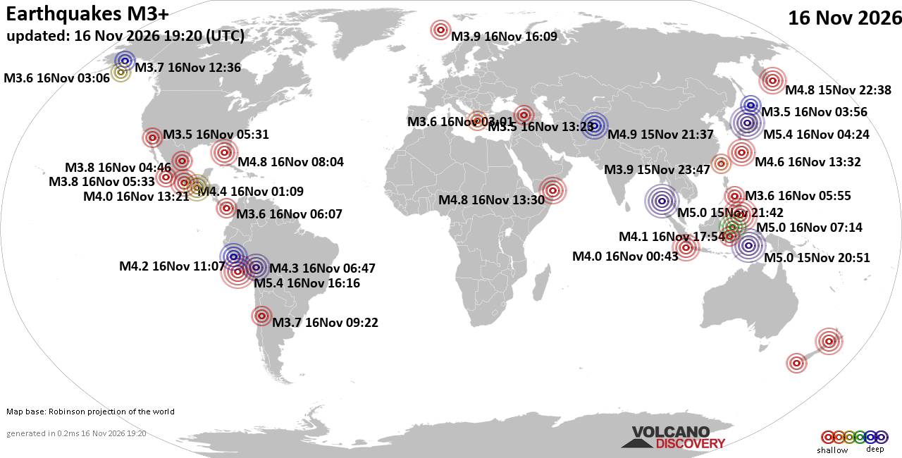
World Earthquake Report for Monday, 16 November 2026
• Moderate mag. 4.5 earthquake - 160 km northwest of Kavieng, New Ireland Pro...
• M 4.4 - off the coast of Oregon
• M 2.3 - 14 km ESE of Clam Gulch, Alaska
• M 3.9 - Rat Islands, Aleutian Islands, Alaska
• M 1.8 - 8 km NW of Round Valley, CA
• M 0.7 - 9 km S of Idyllwild, CA
|

#964238
Sat 14 Nov 2026 11:50:AM
|
Joined: Feb 2001
Posts: 800,656
Launch Director
|
|
Launch Director
Joined: Feb 2001
Posts: 800,656 |
Volcano earthquake report for Saturday, 14 November 2026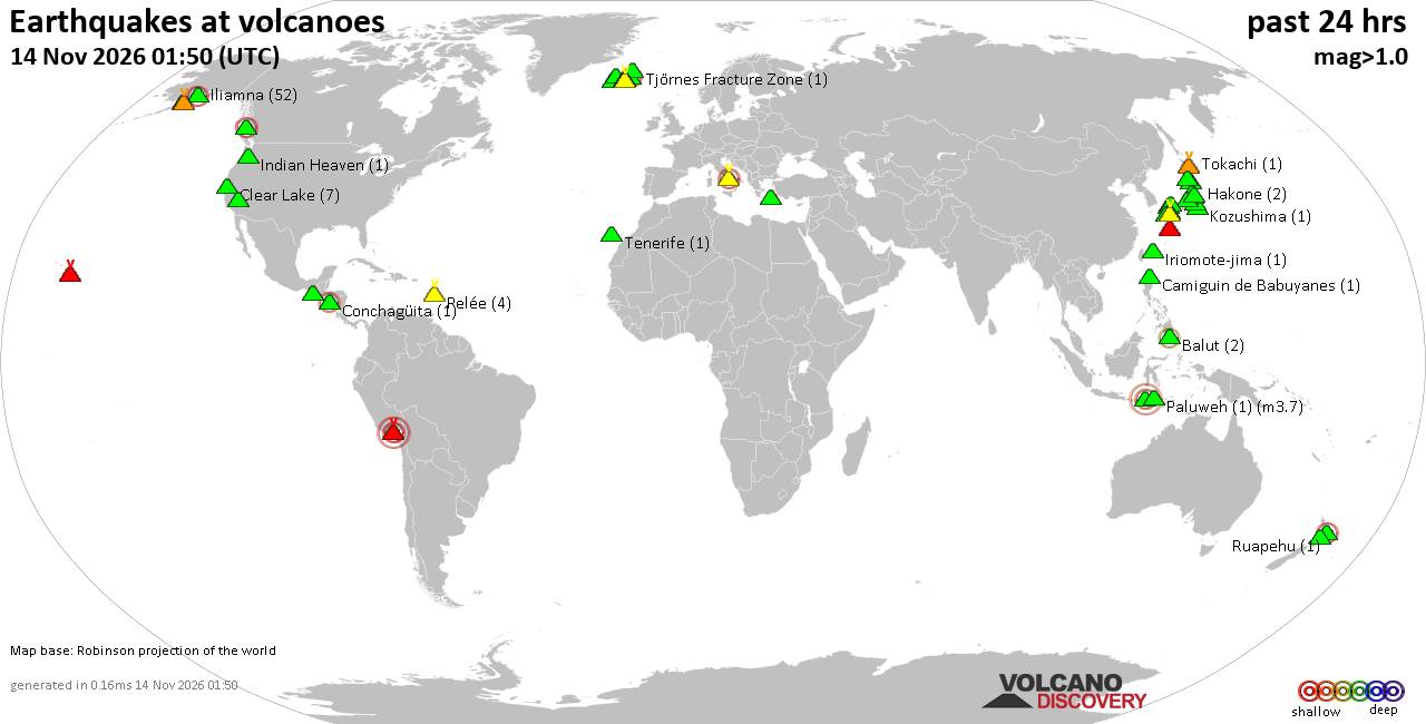 World map showing volcanoes with shallow (less than 50 km) earthquakes within 20 km radius during the past 24 hours on 14 Nov 2026 Number in brackets indicate nr of quakes. Quakes detected near: Abu (2 quakes between mag 0.2-1.6), Aso (2 quakes between mag 0.1-1.7), Balut (3 quakes between mag 1.8-2.4), Bardarbunga (4 quakes between mag 0.3-2.2), Bulusan (1 quake mag 2.9), Chiquimula Volcanic Field (1 quake mag 3.6)
Clear Lake (9 quakes between mag 0.6-2.2), Cleveland (1 quake mag 1.1), Conchagüita (1 quake mag 2.1), Coso (1 quake mag 1.4), Eldey (3 quakes between mag 0.9-1.3), Flores (1 quake mag 1.7), Grímsvötn (1 quake mag 1.1), Hakone (1 quake mag 1.1), Hiuchi (2 quakes between mag 1.1-1.9), Iliamna (26 quakes between mag 0.1-1.3), Iriomote-jima (1 quake mag 1.1), Katmai (2 quakes between mag 0.8-1.6), Kolumbo (1 quake mag 1.8), Ljósufjöll (1 quake mag 1.0), Milbanke Sound (1 quake mag 2.6), Niua (1 quake mag 4.6), Numazawa (10 quakes between mag 0.5-1.7), Okataina (Tarawera) (1 quake mag 2.0), Pelée (6 quakes between mag 0.0-1.8), Reporoa (1 quake mag 1.3), Ruapehu (2 quakes between mag 0.8-1.3), Sanbe (6 quakes between mag 0.3-3.5), Suwanosejima (1 quake mag 1.5), Torfajökull (2 quakes between mag 1.0-1.7), Tsurumi (1 quake mag 1.0), Unzen (13 quakes between mag 0.1-2.2) (updated 11h50)\n\nNote: Earthquakes within 20 km from and at depths less than 50 km under active volcanoes are reported. The list is not complete because many volcanoes are not monitored and/or seismic data in high resolution is not available publicly.\n
Volcanoes with recent earthquakes above magnitude 2 or more than 10 quakes are listed below:
Balut volcano (Mindanao): 3 earthquakes up to magnitude 2.43 earthquakes occurred near (under) the volcano during 10 hours, the last being recorded quake 8 hours ago. Hypocenter depths ranged between 32.00 and 6.00 km. Earthquake details: 2.4 quake Celebes Sea, 27 km west of Sarangani Island, Philippines, Nov 14, 2026 01:53 am (Manila time) (15 km W) 2.1 quake Celebes Sea, 19 km west of Sarangani Island, Philippines, Nov 14, 2026 10:12 am (Manila time) (7 km WSW) 1.8 quake Celebes Sea, 19 km southwest of Sarangani Island, Philippines, Nov 14, 2026 12:06 pm (Manila time) (7 km SW) All earthquakes at BalutBalut is an 840 m island stratovolcano south of Mindanao whose last known eruption occurred between about 2 million and 11,700 years ago. Hot springs and thermally altered ground occur on its western and southwestern flanks. Bardarbunga volcano (Iceland): 4 earthquakes up to magnitude 2.24 earthquakes occurred near (under) the volcano during 6 hours, the last being recorded quake 16 hours ago. Hypocenter depths ranged between 9.80 and 0.00 km. Earthquake details: 2.2 quake 7.8 km E of Bárðarbunga Nov 13, 2026 07:59 pm (Reykjavik time) (8 km E) 0.5 quake 6.4 km E of Bárðarbunga Nov 13, 2026 02:02 pm (Reykjavik time) (7 km ENE) 0.3 quake Iceland: 2.9 km E of Bárðarbunga Nov 13, 2026 02:22 pm (Reykjavik time) (3 km ENE) 0.3 quake Iceland: 5.0 km E of Bárðarbunga Nov 13, 2026 02:22 pm (Reykjavik time) (5 km E) All earthquakes at BardarbungaBárðarbunga is an ice-covered Icelandic stratovolcano whose far-reaching fissure system has produced enormous lava flows and major explosive eruptions. Its 2014-15 Holuhraun eruption created a lava field of almost 85 km². Bulusan volcano (Luzon Island): magnitude 2.9 earthquakeA magnitude 2.9 earthquake occurred at the volcano 10 hours ago. The quake, which might be volcanic in origin, was located at a depth of 9.00 km depth at 4 km distance SSE from the volcano. Earthquake details: 2.9 quake 21 km south of Gubat, Province of Sorsogon, Bicol, Philippines, Nov 14, 2026 09:41 am (Manila time) (4 km SSE) All earthquakes at BulusanBulusan is Luzon’s southernmost volcano and has produced numerous moderate explosive eruptions since the mid-19th century. Its activity commonly takes the form of brief, steam-driven explosions and ashfall. Chiquimula Volcanic Field volcano (Guatemala): magnitude 3.6 earthquakeA magnitude 3.6 earthquake occurred at the volcano 5 hours ago. The quake, which might be volcanic in origin, was located at a depth of 6.00 km depth at 15 km distance N from the volcano. Earthquake details: 3.6 quake 2.2 km west of Zacapa, Departamento de Zacapa, Guatemala, Nov 14, 2026 12:35 am (Guatemala time) (15 km N) All earthquakes at Chiquimula Volcanic FieldThis volcanic field in southeastern Guatemala contains lava flows and numerous cones, some beside Chiquimula town. No historical eruptions are known, although the unmeasured age of youthful-looking lava at Cerro Chiquito remains uncertain. Clear Lake volcano (California): 9 earthquakes up to magnitude 2.29 earthquakes occurred near (under) the volcano during 16 hours, the last being recorded quake 1 hour 10 minutes ago. Hypocenter depths ranged between 3.21 and 1.47 km. Earthquake details: (only 5 largest) 2.2 quake 26 mi north of Santa Rosa, Sonoma County, California, United States, Nov 14, 2026 12:04 am (GMT -8) (18 km SSW) 1.5 quake Sonoma County, 13 mi southwest of Clearlake, Lake County, California, United States, Nov 13, 2026 02:48 pm (GMT -8) (15 km SSW) 1.3 quake Lake County, 25 mi north of Santa Rosa, Sonoma County, California, United States, Nov 13, 2026 11:08 am (GMT -8) (19 km SSE) 1.0 quake 27 mi north of Santa Rosa, Sonoma County, California, United States, Nov 13, 2026 11:57 pm (GMT -8) (16 km SSW) 0.8 quake 26 mi north of Santa Rosa, Sonoma County, California, United States, Nov 14, 2026 01:59 am (GMT -8) (18 km S) All earthquakes at Clear LakeConchagüita volcano (El Salvador): magnitude 2.1 earthquakeA magnitude 2.1 earthquake occurred at the volcano 13 hours ago. The quake, which might be volcanic in origin, was located at a depth of 13.00 km depth at 5 km distance N from the volcano. Earthquake details: 2.1 quake North Pacific Ocean, 10.3 km southeast of La Union, El Salvador, Nov 13, 2026 05:11 pm (GMT -6) (5 km N) All earthquakes at ConchagüitaConchagüita is a 505-m-high island stratovolcano in El Salvador’s Gulf of Fonseca. Its last known eruption occurred more than about 11,700 years ago, and a reported 1892 eruption is discredited. Iliamna volcano (Cook Inlet (SW Alaska)): 26 earthquakes up to magnitude 1.3Possible earthquake swarm: 26 earthquakes occurred near (under) the volcano during 18 hours, the last being recorded quake 5 hours ago. Hypocenter depths ranged between 9.60 and 0.00 km. Earthquake details: (only 5 largest) 1.3 quake Kenai Peninsula Borough, 127 mi southwest of Anchorage, Anchorage Municipality, Alaska, United States, Nov 13, 2026 04:37 am (GMT -9) (16 km E) 1.2 quake Kenai Peninsula Borough, 127 mi southwest of Anchorage, Anchorage Municipality, Alaska, United States, Nov 13, 2026 04:21 am (GMT -9) (16 km E) 1.1 quake Kenai Peninsula Borough, 128 mi southwest of Anchorage, Anchorage Municipality, Alaska, United States, Nov 13, 2026 04:37 am (GMT -9) (12 km ENE) 1.1 quake Kenai Peninsula Borough, 135 mi southwest of Anchorage, Anchorage Municipality, Alaska, United States, Nov 13, 2026 04:17 am (GMT -9) (1 km E) 1.1 quake Kenai Peninsula Borough, 134 mi southwest of Anchorage, Anchorage Municipality, Alaska, United States, Nov 13, 2026 04:30 am (GMT -9) (6 km N) All earthquakes at IliamnaIliamna is a glacier-covered Alaskan stratovolcano whose conspicuous fumarolic steam plumes have sometimes been mistaken for eruptions. Its last confirmed eruption occurred in 1876, although uncertain reports continued into the 1950s. Milbanke Sound volcano (Canada): magnitude 2.6 earthquakeA magnitude 2.6 earthquake occurred at the volcano 15 hours ago. The quake, which might be volcanic in origin, was located at a depth of 0 km depth at 8 km distance ENE from the volcano. Earthquake details: 2.6 quake Regional District of Kitimat-Stikine, 50 km northwest of Bella Bella, Central Coast Regional District, British Columbia, Canada, Nov 13, 2026 01:58 pm (GMT -7) (8 km ENE) All earthquakes at Milbanke SoundMilbanke Sound comprises basaltic cones and lava flows spread across several islands in west-central British Columbia. Some features are assigned to approximately the past 12,000 years, but no historical eruption is known. Niua volcano (Tonga): magnitude 4.6 earthquakeA magnitude 4.6 earthquake occurred at the volcano 5 hours ago. The quake, which might be volcanic in origin, was located at a depth of 10.00 km depth at 12 km distance ENE from the volcano. Earthquake details: 4.6 quake South Pacific Ocean, 228 km southwest of Apia, Tuamasaga, Samoa, Nov 14, 2026 08:02 pm (GMT +13) (12 km ENE) All earthquakes at NiuaNiua is a large, irregular submarine volcanic complex in Tonga. Its last known eruption occurred more than approximately 11,700 years ago. Sanbe volcano (Honshu): 6 earthquakes up to magnitude 3.56 earthquakes occurred near (under) the volcano during 10 hours, the last being recorded quake 11 hours ago. Hypocenter depths ranged between 12.10 and 10.00 km. Earthquake details: (only 5 largest) 3.5 quake 8.4 km east of Odacho-oda, Shimane, Japan, Nov 14, 2026 12:03 am (GMT +9) (7 km NNW) 1.1 quake 3.5 km east of Odacho-oda, Shimane, Japan, Nov 14, 2026 09:50 am (GMT +9) (8 km WNW) 0.7 quake 3.5 km east of Odacho-oda, Shimane, Japan, Nov 13, 2026 11:38 pm (GMT +9) (8 km WNW) 0.4 quake 5.4 km southeast of Odacho-oda, Shimane, Japan, Nov 14, 2026 12:52 am (GMT +9) (7 km WNW) 0.3 quake 4.1 km southeast of Odacho-oda, Shimane, Japan, Nov 14, 2026 09:03 am (GMT +9) (8 km WNW) All earthquakes at SanbeSanbe is a 1,126 m stratovolcano in southwestern Honshu with a small summit caldera and several lava domes. Its three known eruptive periods span about 3550 BCE to 650 CE. Unzen volcano (Kyushu): 13 earthquakes up to magnitude 2.2Possible earthquake swarm: 13 earthquakes occurred near (under) the volcano during 20 hours, the last being recorded quake 2 hours ago. Hypocenter depths ranged between 17.40 and 13.60 km. Earthquake details: (only 5 largest) 2.2 quake 23 km east of Nagasaki, Nagasaki, Japan, Nov 14, 2026 03:00 am (GMT +9) (18 km WSW) 1.4 quake East China Sea, 24 km east of Nagasaki, Nagasaki, Japan, Nov 14, 2026 09:40 am (GMT +9) (17 km WSW) 1.4 quake East China Sea, 24 km east of Nagasaki, Nagasaki, Japan, Nov 14, 2026 02:28 am (GMT +9) (17 km WSW) 1.1 quake East China Sea, 24 km east of Nagasaki, Nagasaki, Japan, Nov 14, 2026 10:17 am (GMT +9) (17 km WSW) 0.8 quake East China Sea, 24 km east of Nagasaki, Nagasaki, Japan, Nov 14, 2026 02:45 am (GMT +9) (17 km WSW) All earthquakes at UnzenUnzen is a volcanic complex on Kyushu whose 1792 collapse and tsunami caused about 15,000 deaths. Deadly pyroclastic flows accompanied summit lava-dome growth in 1990-95, followed by smaller collapse-generated flows in 1996. https://www.volcanodiscovery.com/earthquakes-volcanoes/news/412654/Volcano-earthquake-report-2026-11-14.html
|
|



CMS The Best Conveyancing solicitors conveyancing quotes throughout the UK
For any webhosting enquiries please email webmaster@aus-city.com
|
|
Forums60
Topics930,716
Posts965,513
Members2,960
| |
Most Online102,106
Jul 10th, 2026
|
|
|
|
|

|









































