|
|
|
0 members (),
4,970
guests, and
27
robots. |
|
Key:
Admin,
Global Mod,
Mod
|
|
S |
M |
T |
W |
T |
F |
S |
|
1
|
2
|
3
|
4
|
5
|
6
|
7
|
|
8
|
9
|
10
|
11
|
12
|
13
|
14
|
|
15
|
16
|
17
|
18
|
19
|
20
|
21
|
|
22
|
23
|
24
|
25
|
26
|
27
|
28
|
|
There are no members with birthdays on this day. |
|
|
Joined: Feb 2001
Posts: 381,904
Launch Director
|
OP

Launch Director
Joined: Feb 2001
Posts: 381,904 |
Moderate magnitude 4.4 quake hits 58 km northeast of Chosica, Peru early evening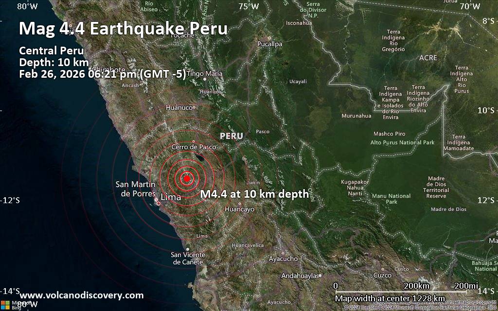 A magnitude 4.4 earthquake near Chosica, Lima, Lima region, Peru, was reported only 27 minutes ago by the German Research Centre for Geosciences (GFZ), considered one of the key international agencies that monitor seismic activity worldwide. The earthquake occurred at a shallow depth of 10. km beneath the epicenter early evening on Thursday, February 26th, 2026, at 6:21 pm local time. The exact magnitude, epicenter, and depth of the quake might be revised within the next few hours or minutes as seismologists review data and refine their calculations, or as other agencies issue their report.
Our monitoring service identified a second report from The Colombian Geological Service (SGC) which listed the quake at magnitude 4.8. A third agency, the citizen-seismograph network of RaspberryShake, reported the same quake at magnitude 4.4.
Based on the preliminary seismic data, the quake was probably felt by many people in the area of the epicenter. It should not have caused significant damage, other than objects falling from shelves, broken windows, etc.
In Marcapomacocha (pop. 360) located 14 km from the epicenter, the quake should have been felt as light shaking.
Weak shaking might have been felt in La Oroya (pop. 33,300) located 55 km from the epicenter.
Other towns or cities near the epicenter where the quake might have been felt as very weak shaking include Chosica (pop. 88,600) located 58 km from the epicenter, Junin (pop. 15,300) 60 km away, Tarma (pop. 51,400) 79 km away, Santa Anita - Los Ficus (pop. 184,600) 86 km away, Lima (pop. 7,737,000) 90 km away, San Francisco De Borja (pop. 105,100) 91 km away, Brena (pop. 81,900) 93 km away, and Callao (pop. 1,300,000) 99 km away.
VolcanoDiscovery will automatically update magnitude and depth if these change and follow up if other significant news about the quake become available. If you’re in the area, please send us your experience through our reporting mechanism, either online or via our mobile app. This will help us provide more first-hand updates to anyone around the globe who wants to know more about this quake.
Earthquake data: Date & time: Feb 26, 2026 06:21 pm (GMT -5) local time (26 Feb 2026 23:21 GMT)Magnitude: 4.4 Depth: 10.00 km Epicenter latitude / longitude: 11.52°S / 76.41°W  (Daniel Alcides Carrion, Lima region, Peru) Primary data source: GFZhttps://www.volcanodiscovery.com/earthquake/news/296061/Moderate-magnitude-44-quake-hits-58-km-northeast-of-Chosica-Peru-early-evening-.html
|
|


CMS The Best Conveyancing solicitors conveyancing quotes throughout the UK
For any webhosting enquiries please email webmaster@aus-city.com
|
|
Forums60
Topics763,561
Posts798,299
Members2,958
| |
Most Online17,963
Jan 15th, 2026
|
|
|
|
|
Copyright 1996 - 2026 by David Cottle. Designed by David Bate Jr. All Rights Reserved.
By using this forum, the user agrees not to transfer any data or technical information received under the agreement, to any other entity without the express approval of the AUS-CITY Forum Admins and/or authors of individual posts (Forum Admins and DoD/USSPACECOM for the analysis of satellite tracking data).
Two-line elements (TLE) and all other satellite data presented and distributed via this forum and e-mail lists of AUS-CITY are distributed with permission from DoD/USSTRATCOM.

Reprise Hosting

|

|


 - Click image for larger picture.")


