|
|
|
0 members (),
4,573
guests, and
20
robots. |
|
Key:
Admin,
Global Mod,
Mod
|
|
S |
M |
T |
W |
T |
F |
S |
|
1
|
2
|
3
|
4
|
5
|
6
|
7
|
|
8
|
9
|
10
|
11
|
12
|
13
|
14
|
|
15
|
16
|
17
|
18
|
19
|
20
|
21
|
|
22
|
23
|
24
|
25
|
26
|
27
|
28
|
|
29
|
30
|
31
|
|
|
|
|
|
There are no members with birthdays on this day. |
|
|
Joined: Feb 2001
Posts: 381,904
Launch Director
|
OP

Launch Director
Joined: Feb 2001
Posts: 381,904 |
Small magnitude 2.9 quake hits 23 miles southeast of Katanning, Western Australia, Australia around noon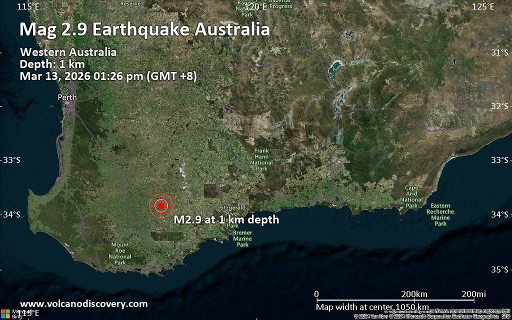 An earthquake of magnitude 2.9 occurred around noon on Friday, March 13th, 2026, at 1:26 pm local time near Katanning, Western Australia, Australia, as reported by the European-Mediterranean Seismological Centre (EMSC).
According to preliminary data, the quake was located at a very shallow depth of 0.4 miles. Shallow earthquakes are felt more strongly than deeper ones as they are closer to the surface. The exact magnitude, epicenter, and depth of the quake might be revised within the next few hours or minutes as seismologists review data and refine their calculations, or as other agencies issue their report.
Towns or cities near the epicenter where the quake might have been felt as very weak shaking include Pallinup (pop. 78) located 5 miles from the epicenter, Gnowangerup (pop. 590) 9 miles away, and Jackitup (pop. 60) 11 miles away. In Broomehill (pop. 380, 16 miles away), Tambellup (pop. 370, 21 miles away), Katanning (pop. 3,700, 23 miles away), Nyabing (pop. 290, 25 miles away), and Kojonup (pop. 1,200, 43 miles away), the quake was probably not felt.
Earthquake data: Date & time: 2026-03-13 13:26 local time (13 Mar 2026 05:26 GMT)Magnitude: 2.8 Depth: 0.74 km Epicenter latitude / longitude: 33.84°S / 117.91°E  ( Gnowangerup, Australia) Primary data source: GeoAuhttps://www.volcanodiscovery.com/earthquake/news/297500/Small-magnitude-29-quake-hits-23-miles-southeast-of-Katanning-Western-Australia-Australia-around-noo.html
|
|


CMS The Best Conveyancing solicitors conveyancing quotes throughout the UK
For any webhosting enquiries please email webmaster@aus-city.com
|
|
Forums60
Topics765,641
Posts800,393
Members2,958
| |
Most Online17,963
Jan 15th, 2026
|
|
|
|
|
Copyright 1996 - 2026 by David Cottle. Designed by David Bate Jr. All Rights Reserved.
By using this forum, the user agrees not to transfer any data or technical information received under the agreement, to any other entity without the express approval of the AUS-CITY Forum Admins and/or authors of individual posts (Forum Admins and DoD/USSPACECOM for the analysis of satellite tracking data).
Two-line elements (TLE) and all other satellite data presented and distributed via this forum and e-mail lists of AUS-CITY are distributed with permission from DoD/USSTRATCOM.

Reprise Hosting

|

|


 - Click image for larger picture.")


