|
|
|
0 members (),
2,055
guests, and
24
robots. |
|
Key:
Admin,
Global Mod,
Mod
|
|
S |
M |
T |
W |
T |
F |
S |
|
1
|
2
|
3
|
4
|
5
|
6
|
7
|
|
8
|
9
|
10
|
11
|
12
|
13
|
14
|
|
15
|
16
|
17
|
18
|
19
|
20
|
21
|
|
22
|
23
|
24
|
25
|
26
|
27
|
28
|
|
29
|
30
|
31
|
|
|
|
|
|
There are no members with birthdays on this day. |
|
|
Joined: Feb 2001
Posts: 381,904
Launch Director
|
OP

Launch Director
Joined: Feb 2001
Posts: 381,904 |
Volcano earthquake report for Friday, 20 Mar 2026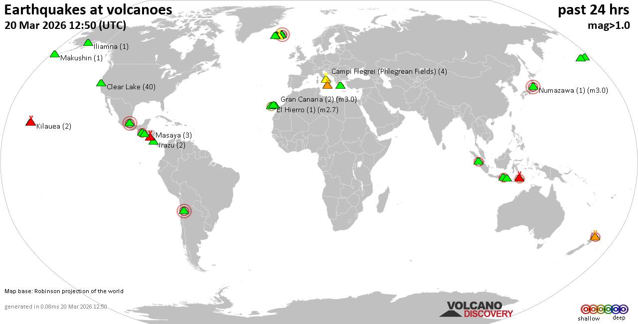 World map showing volcanoes with shallow (less than 50 km) earthquakes within 20 km radius during the past 24 hours on 20 Mar 2026 Number in brackets indicate nr of quakes. Quakes detected near: Agua (1 quake mag 2.2), Atka (1 quake mag 1.9), Bardarbunga (6 quakes between mag 0.2-3.8), Bobrof (1 quake mag 1.2), Brennisteinsfjöll (6 quakes between mag 0.0-1.1), Campi Flegrei (Phlegrean Fields) (4 quakes between mag 0.1-1.1)
Clear Lake (38 quakes between mag 0.2-1.5), Colima (1 quake mag 3.3), Coso (2 quakes between mag 0.8-1.0), El Hierro (1 quake mag 2.7), Etna (1 quake mag 1.1), Hiuchi (1 quake mag 3.0), Ibu (1 quake mag 3.6), Iliamna (1 quake mag 1.1), Irazu (1 quake mag 1.2), Katla (2 quakes between mag 0.7-1.3), Katmai (1 quake mag 1.1), Kilauea (1 quake mag 1.8), Lewotolo (1 quake mag 2.3), Loki-Fögrufjöll volcano (1 quake mag 1.4), Makushin (1 quake mag 1.2), Masaya (3 quakes between mag 1.0-1.4), Maunaloa (3 quakes between mag 1.9-2.1), Nemrut Dagi (1 quake mag 1.6), Numazawa (1 quake mag 3.0), Papayo (1 quake mag 3.0), Piton de la Fournaise (2 quakes between mag 1.5-1.5), Rinjani (2 quakes between mag 2.1-2.1), San Salvador (1 quake mag 3.0), Shishaldin (1 quake mag 1.7), Tenerife (3 quakes between mag 1.4-1.9), Torfajökull (1 quake mag 1.1), White Island (3 quakes between mag 2.1-2.4) (updated 18h50)
Note: Earthquakes within 20 km from and at depths less than 50 km under active volcanoes are reported. The list is not complete because many volcanoes are not monitored and/or seismic data in high resolution is not available publicly.
Volcanoes with recent earthquakes above magnitude 2 or more than 10 quakes are listed below:
Agua volcano (Guatemala): magnitude 2.2 earthquakeA magnitude 2.2 earthquake occurred at the volcano 12 hours ago. The quake, which might be volcanic in origin, was located at a depth of 2.00 km depth at 6 km distance SSE from the volcano. Earthquake details: 2.2 quake 3.3 km west of Palin, Departamento de Escuintla, Guatemala, Mar 20, 2026 12:40 am (GMT -6) (6 km SSE) All earthquakes at AguaBardarbunga volcano (Iceland): 6 earthquakes up to magnitude 3.86 earthquakes occurred near (under) the volcano during 13 hours, the last being recorded quake 8 hours ago. Hypocenter depths ranged between 16.10 and 0.00 km. Earthquake details: (only 5 largest) 3.8 quake Northeast, 224 km east of Reykjavik, Capital Region, Iceland, Mar 19, 2026 11:23 pm (Reykjavik time) (7 km E) 1.2 quake 6.7 km E of Bárðarbunga Mar 20, 2026 02:19 am (Universal Time) (7 km E) 0.6 quake 17.5 km ESE of Bárðarbunga Mar 20, 2026 11:12 am (Universal Time) (17 km ESE) 0.4 quake Iceland: 19.6 km ESE of Bárðarbunga Mar 20, 2026 11:06 am (Reykjavik time) (19 km ESE) 0.4 quake Iceland: 6.8 km E of Bárðarbunga Mar 19, 2026 09:59 pm (Reykjavik time) (7 km ENE) All earthquakes at BardarbungaClear Lake volcano (California): 38 earthquakes up to magnitude 1.5Possible earthquake swarm: 38 earthquakes occurred near (under) the volcano during 21 hours, the last being recorded quake 2 hours ago. Hypocenter depths ranged between 11.86 and 0.24 km. Earthquake details: (only 5 largest) 1.5 quake 27 mi north of Santa Rosa, Sonoma County, California, United States, Mar 19, 2026 08:48 pm (GMT -7) (18 km SSW) 1.5 quake Sonoma County, 13 mi southwest of Clearlake, Lake County, California, United States, Mar 19, 2026 06:30 pm (GMT -7) (16 km S) 1.4 quake Lake County, 27 mi north of Santa Rosa, Sonoma County, California, United States, Mar 20, 2026 09:24 am (GMT -7) (16 km S) 1.3 quake 28 mi north of Santa Rosa, Sonoma County, California, United States, Mar 20, 2026 07:02 am (GMT -7) (18 km SSW) 1.3 quake Lake County, 26 mi north of Santa Rosa, Sonoma County, California, United States, Mar 19, 2026 10:41 pm (GMT -7) (17 km S) All earthquakes at Clear LakeColima volcano (Western & Central Mexico): magnitude 3.3 earthquakeA magnitude 3.3 earthquake occurred at the volcano 14 hours ago. The quake, which might be volcanic in origin, was located at a depth of 27.40 km depth at 16 km distance WNW from the volcano. Earthquake details: 3.3 quake 35 km southwest of Ciudad Guzman, Estado de Jalisco, Mexico, Mar 19, 2026 11:13 pm (GMT -6) (16 km WNW) All earthquakes at ColimaEl Hierro volcano (Canary Islands): magnitude 2.7 earthquakeA magnitude 2.7 earthquake occurred at the volcano 22 hours ago. The quake, which might be volcanic in origin, was located at a depth of 32.20 km depth at 6 km distance NW from the volcano. Earthquake details: 2.7 quake 10.1 km south of Frontera, Santa Cruz de Tenerife, Canary Islands, Spain, Mar 19, 2026 08:51 pm (Universal Time) (6 km NW) All earthquakes at El HierroHiuchi volcano (Honshu): magnitude 3.0 earthquakeA magnitude 3.0 earthquake occurred at the volcano 5 hours ago. The quake, which might be volcanic in origin, was located at a depth of 10.00 km depth at 8 km distance NNW from the volcano. Earthquake details: Unconfirmed earthquake or seismic-like event: Fukushima, 36 km southeast of Uonuma, Niigata, Japan, Mar 20, 2026 10:29 pm (GMT +9) (8 km NNW) All earthquakes at HiuchiIbu volcano (Halmahera): magnitude 3.6 earthquakeA magnitude 3.6 earthquake occurred at the volcano 1 hour 36 minutes ago. The quake, which might be volcanic in origin, was located at a depth of 10.00 km depth at 12 km distance E from the volcano. Earthquake details: 3.6 quake 40 km southwest of Tobelo, Kabupaten Halmahera Utara, North Maluku, Indonesia, Mar 21, 2026 02:13 am (Jayapura time) (12 km E) All earthquakes at IbuLewotolo volcano (Lesser Sunda Islands): magnitude 2.3 earthquakeA magnitude 2.3 earthquake occurred at the volcano 22 hours ago. The quake, which might be volcanic in origin, was located at a depth of 17.00 km depth at 3 km distance NNE from the volcano. Earthquake details: 2.3 quake 17 km northeast of Lewoleba, Kabupaten Lembata, East Nusa Tenggara, Indonesia, Mar 20, 2026 04:32 am (GMT +8) (3 km NNE) All earthquakes at LewotoloMaunaloa volcano (Hawai'i (Big Island)): 3 earthquakes up to magnitude 2.13 earthquakes occurred near (under) the volcano during 14 hours, the last being recorded quake 4 hours ago. Hypocenter depths ranged between 15.36 and 3.63 km. Earthquake details: 2.1 quake 35 mi southwest of Hilo, Hawaii County, Hawaii, United States, Mar 20, 2026 04:46 am (GMT -10) (11 km ESE) 2.0 quake 29 mi southwest of Hilo, Hawaii County, Hawaii, United States, Mar 19, 2026 03:11 pm (GMT -10) (17 km E) 1.9 quake 30 mi southwest of Hilo, Hawaii County, Hawaii, United States, Mar 19, 2026 05:00 pm (GMT -10) (15 km E) All earthquakes at MaunaloaNumazawa volcano (Honshu): magnitude 3.0 earthquakeA magnitude 3.0 earthquake occurred at the volcano 15 hours ago. The quake, which might be volcanic in origin, was located at a depth of 10.00 km depth at 17 km distance W from the volcano. Earthquake details: Reported seismic-like event (likely no quake): 35 km southeast of Gosen, Niigata, Japan, Mar 20, 2026 12:36 pm (GMT +9) (17 km W) All earthquakes at NumazawaPapayo volcano (Western & Central Mexico): magnitude 3.0 earthquakeA magnitude 3.0 earthquake occurred at the volcano 22 hours ago. The quake, which might be volcanic in origin, was located at a depth of 10.00 km depth at 8 km distance NNE from the volcano. Earthquake details: Reported seismic-like event (likely no quake): 32 km east of Xico, México, Mexico, Mar 19, 2026 03:18 pm (GMT -6) (8 km NNE) All earthquakes at PapayoRinjani volcano (Lombok): 2 earthquakes up to magnitude 2.12 earthquakes occurred near (under) the volcano during 1 hour 23 minutes, the last being recorded quake 18 hours ago. Hypocenter depths ranged between 23.00 and 19.00 km. Earthquake details: 2.1 quake 30 km north of Selong, Kabupaten Lombok Timur, West Nusa Tenggara, Indonesia, Mar 20, 2026 08:35 am (GMT +8) (4 km WNW) 2.1 quake 31 km north of Selong, Kabupaten Lombok Timur, West Nusa Tenggara, Indonesia, Mar 20, 2026 07:13 am (GMT +8) (10 km ENE) All earthquakes at RinjaniSan Salvador volcano (El Salvador): magnitude 3.0 earthquakeA magnitude 3.0 earthquake occurred at the volcano 14 hours ago. The quake, which might be volcanic in origin, was located at a depth of 10.00 km depth at 8 km distance ESE from the volcano. Earthquake details: Reported seismic-like event (likely no quake): 4.8 km northwest of San Salvador, Departamento de San Salvador, El Salvador, Mar 19, 2026 11:14 pm (GMT -6) (8 km ESE) All earthquakes at San SalvadorWhite Island volcano (New Zealand): 3 earthquakes up to magnitude 2.43 earthquakes occurred near (under) the volcano during 13 hours, the last being recorded quake 37 minutes ago. Hypocenter depths ranged between 7.30 and 5.00 km. Earthquake details: 2.4 quake South Pacific Ocean, 58 km north of Whakatane, Bay of Plenty, New Zealand, Mar 21, 2026 07:13 am (GMT +13) (6 km NNE) 2.2 quake South Pacific Ocean, 53 km north of Whakatane, Bay of Plenty, New Zealand, Mar 20, 2026 06:25 pm (GMT +13) (3 km E) 2.1 quake South Pacific Ocean, 91 km east of Tauranga, Bay of Plenty, New Zealand, Mar 20, 2026 11:49 pm (GMT +13) (8 km NNW) All earthquakes at White Islandhttps://www.volcanodiscovery.com/earthquakes-volcanoes/news/298017/Volcano-earthquake-report-for-Friday-20-Mar-2026.html
|
|


CMS The Best Conveyancing solicitors conveyancing quotes throughout the UK
For any webhosting enquiries please email webmaster@aus-city.com
|
|
Forums60
Topics766,360
Posts801,114
Members2,958
| |
Most Online17,963
Jan 15th, 2026
|
|
|
|
|
Copyright 1996 - 2026 by David Cottle. Designed by David Bate Jr. All Rights Reserved.
By using this forum, the user agrees not to transfer any data or technical information received under the agreement, to any other entity without the express approval of the AUS-CITY Forum Admins and/or authors of individual posts (Forum Admins and DoD/USSPACECOM for the analysis of satellite tracking data).
Two-line elements (TLE) and all other satellite data presented and distributed via this forum and e-mail lists of AUS-CITY are distributed with permission from DoD/USSTRATCOM.

Reprise Hosting

|

|


 - Click image for larger picture.")


