|
|
|
0 members (),
986
guests, and
11
robots. |
|
Key:
Admin,
Global Mod,
Mod
|
|
S |
M |
T |
W |
T |
F |
S |
|
|
|
|
1
|
2
|
3
|
4
|
|
5
|
6
|
7
|
8
|
9
|
10
|
11
|
|
12
|
13
|
14
|
15
|
16
|
17
|
18
|
|
19
|
20
|
21
|
22
|
23
|
24
|
25
|
|
26
|
27
|
28
|
29
|
30
|
|
|
|
There are no members with birthdays on this day. |
|
|
Joined: Feb 2001
Posts: 381,904
Launch Director
|
OP

Launch Director
Joined: Feb 2001
Posts: 381,904 |
Small earthquake of magnitude 3.0 just reported 7 km northwest of Armenia, Colombia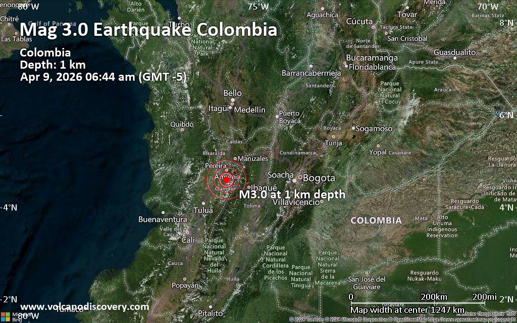 Just 15 minutes ago, a 3.0-magnitude earthquake struck near Armenia, Quindio Department, Colombia. The tremor was recorded early morning on Thursday, April 9th, 2026, at 6:44 am local time, at a very shallow depth of 1. km below the surface.
The event was filed by the citizen-seismograph network of RaspberryShake, the first seismological agency to report it.
Based on the preliminary seismic data, the quake should not have caused any significant damage, but was probably felt by many people as light vibration in the area of the epicenter.
Weak shaking might have been felt in Circasia (pop. 27,100) located 7 km from the epicenter, Montenegro (pop. 42,000) 7 km away, Armenia (pop. 304,300) 7 km away, and Quimbaya (pop. 35,400) 8 km away.
Other towns or cities near the epicenter where the quake might have been felt as very weak shaking include Calarca (pop. 79,600) located 10 km from the epicenter, La Tebaida (pop. 27,100) 19 km away, Pereira (pop. 467,300) 24 km away, and Dosquebradas (pop. 206,700) 27 km away. In Ibague (pop. 529,600, 58 km away), the quake was probably not felt.
Earthquake data: Date & time: Apr 9, 2026 06:44 am (GMT -5) local time (9 Apr 2026 11:44 GMT)Magnitude: 3.0 Depth: 1.00 km Epicenter latitude / longitude: 4.6°N / 75.7°W  ( Armenia, Quindio Department, Colombia) Primary data source: RaspberryShakehttps://www.volcanodiscovery.com/earthquake/news/299604/Small-earthquake-of-magnitude-30-just-reported-7-km-northwest-of-Armenia-Colombia.html
|
|


CMS The Best Conveyancing solicitors conveyancing quotes throughout the UK
For any webhosting enquiries please email webmaster@aus-city.com
|
|
Forums60
Topics768,227
Posts802,991
Members2,958
| |
Most Online17,963
Jan 15th, 2026
|
|
|
|
|
Copyright 1996 - 2026 by David Cottle. Designed by David Bate Jr. All Rights Reserved.
By using this forum, the user agrees not to transfer any data or technical information received under the agreement, to any other entity without the express approval of the AUS-CITY Forum Admins and/or authors of individual posts (Forum Admins and DoD/USSPACECOM for the analysis of satellite tracking data).
Two-line elements (TLE) and all other satellite data presented and distributed via this forum and e-mail lists of AUS-CITY are distributed with permission from DoD/USSTRATCOM.

Reprise Hosting

|

|


 - Click image for larger picture.")


