|
|
|
0 members (),
1,654
guests, and
15
robots. |
|
Key:
Admin,
Global Mod,
Mod
|
|
S |
M |
T |
W |
T |
F |
S |
|
|
|
|
1
|
2
|
3
|
4
|
|
5
|
6
|
7
|
8
|
9
|
10
|
11
|
|
12
|
13
|
14
|
15
|
16
|
17
|
18
|
|
19
|
20
|
21
|
22
|
23
|
24
|
25
|
|
26
|
27
|
28
|
29
|
30
|
|
|
|
There are no members with birthdays on this day. |
|
|
Joined: Feb 2001
Posts: 381,904
Launch Director
|
OP

Launch Director
Joined: Feb 2001
Posts: 381,904 |
Volcano earthquake report for Monday, 20 Apr 2026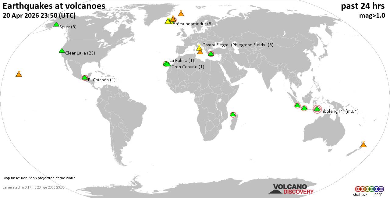 World map showing volcanoes with shallow (less than 50 km) earthquakes within 20 km radius during the past 24 hours on 20 Apr 2026 Number in brackets indicate nr of quakes. Quakes detected near: Campi Flegrei (Phlegrean Fields) (5 quakes between mag 0.1-1.0), Clear Lake (28 quakes between mag 0.2-2.1), El Chichón (2 quakes between mag 2.1-2.3), Eldey (5 quakes between mag 0.5-1.2), Etna (2 quakes between mag 1.2-1.5), Gran Canaria (1 quake mag 1.1)
Hofsjökull (1 quake mag 1.1), Hrómundartindur (4 quakes between mag 0.0-1.9), Hulubelu (2 quakes between mag 2.2-2.9), Iliboleng (4 quakes between mag 2.2-3.4), Jan Mayen (2 quakes between mag 1.6-1.7), Katla (5 quakes between mag 0.0-1.9), Kilauea (6 quakes between mag 1.1-2.2), Kolumbo (5 quakes between mag 1.1-2.0), La Palma (2 quakes between mag 1.8-2.1), Lawu (1 quake mag 2.6), Ljósufjöll (4 quakes between mag 0.1-1.4), Loihi (5 quakes between mag 1.7-3.4), Maunaloa (1 quake mag 1.5), Mayotte Island (2 quakes between mag 0.8-2.1), Sousaki (1 quake mag 1.2), Spurr (4 quakes between mag 0.6-1.3), Svartsengi (3 quakes between mag 0.0-1.1), Tenerife (7 quakes between mag 0.6-1.5), Theistareykjarbunga (2 quakes between mag 0.9-2.3), Tjörnes Fracture Zone (36 quakes between mag 0.0-1.4), Whale Island (3 quakes between mag 2.0-2.5) (updated 20h50)
Note: Earthquakes within 20 km from and at depths less than 50 km under active volcanoes are reported. The list is not complete because many volcanoes are not monitored and/or seismic data in high resolution is not available publicly.
Volcanoes with recent earthquakes above magnitude 2 or more than 10 quakes are listed below:
Clear Lake volcano (California): 28 earthquakes up to magnitude 2.1Possible earthquake swarm: 28 earthquakes occurred near (under) the volcano during 23 hours, the last being recorded quake 27 minutes ago. Hypocenter depths ranged between 3.60 and 0.03 km. Earthquake details: (only 5 largest) 2.1 quake Sonoma County, 13 mi southwest of Clearlake, Lake County, California, United States, Apr 20, 2026 06:32 am (GMT -7) (18 km S) 1.8 quake 13 mi southwest of Clearlake, Lake County, California, United States, Apr 20, 2026 09:18 am (GMT -7) (15 km S) 1.3 quake 26 mi north of Santa Rosa, Sonoma County, California, United States, Apr 19, 2026 05:26 pm (GMT -7) (19 km SSW) 1.3 quake 27 mi north of Santa Rosa, Sonoma County, California, United States, Apr 20, 2026 07:52 am (GMT -7) (17 km S) 1.3 quake 28 mi north of Santa Rosa, Sonoma County, California, United States, Apr 20, 2026 11:31 am (GMT -7) (16 km SSW) All earthquakes at Clear LakeEl Chichón volcano (Southern Mexico): 2 earthquakes up to magnitude 2.32 earthquakes occurred near (under) the volcano during 4 hours, the last being recorded quake 20 hours ago. Hypocenter depths ranged between 3.00 and 2.50 km. Earthquake details: 2.3 quake Estado de Chiapas, 37 km southwest of Teapa, Estado de Tabasco, Mexico, Apr 19, 2026 06:58 pm (GMT -6) (1 km NNW) 2.1 quake Estado de Chiapas, 37 km southwest of Teapa, Estado de Tabasco, Mexico, Apr 19, 2026 02:53 pm (GMT -6) (0 km NNW) All earthquakes at El ChichónHulubelu volcano (Sumatra): 2 earthquakes up to magnitude 2.92 earthquakes occurred near (under) the volcano during 4 minutes, the last being recorded quake 20 hours ago. Hypocenter depths ranged between 24.00 and 22.00 km. Earthquake details: 2.9 quake Kabupaten Tanggamus, 90 km west of Bandar Lampung, Indonesia, Apr 20, 2026 07:56 am (GMT +7) (18 km SW) 2.2 quake Kabupaten Tanggamus, 81 km west of Bandar Lampung, Indonesia, Apr 20, 2026 08:00 am (GMT +7) (8 km SW) All earthquakes at HulubeluIliboleng volcano (Lesser Sunda Islands): 4 earthquakes up to magnitude 3.44 earthquakes occurred near (under) the volcano during 3 hours, the last being recorded quake 4 hours ago. Hypocenter depths ranged between 11.00 and 3.00 km. Earthquake details: 3.4 quake Savu Sea, 16 km east of Pulau Solor Island, East Nusa Tenggara, Indonesia, Apr 20, 2026 09:36 pm (GMT +8) (19 km SW) 3.1 quake 32 km west of Lewoleba, Kabupaten Lembata, East Nusa Tenggara, Indonesia, Apr 21, 2026 12:35 am (GMT +8) (17 km SW) 2.9 quake Savu Sea, 12 km southwest of Pulau Adonara Island, East Nusa Tenggara, Indonesia, Apr 20, 2026 09:55 pm (GMT +8) (17 km WSW) 2.2 quake Kabupaten Flores Timur, 31 km west of Lewoleba, Indonesia, Apr 20, 2026 09:40 pm (GMT +8) (17 km SW) All earthquakes at IlibolengKilauea volcano (Hawai'i (Big Island)): 6 earthquakes up to magnitude 2.26 earthquakes occurred near (under) the volcano during 15 hours, the last being recorded quake 4 hours ago. Hypocenter depths ranged between 31.58 and 0.01 km. Earthquake details: (only 5 largest) 2.2 quake 33 mi southwest of Hilo, Hawaii County, Hawaii, United States, Apr 19, 2026 03:34 pm (GMT -10) (12 km SW) 2.1 quake 8.2 mi northeast of Pāhala, Hawaii County, Hawaii, United States, Apr 20, 2026 01:17 am (GMT -10) (18 km SSW) 1.8 quake 26 mi southwest of Hilo, Hawaii County, Hawaii, United States, Apr 19, 2026 08:09 pm (GMT -10) (1 km ESE) 1.7 quake 30 mi south of Hilo, Hawaii County, Hawaii, United States, Apr 20, 2026 06:31 am (GMT -10) (13 km SE) 1.7 quake 37 mi southwest of Hilo, Hawaii County, Hawaii, United States, Apr 20, 2026 03:33 am (GMT -10) (18 km SSW) All earthquakes at KilaueaLa Palma volcano (Canary Islands): 2 earthquakes up to magnitude 2.12 earthquakes occurred near (under) the volcano during 8 hours, the last being recorded quake 14 hours ago. Hypocenter depths ranged between 28.60 and 14.80 km. Earthquake details: 2.1 quake 5.8 km southwest of Los Llanos de Aridane, Spain, Apr 20, 2026 07:35 am (GMT +1) (12 km WNW) 1.8 quake 12 km southeast of Los Llanos de Aridane, Spain, Apr 19, 2026 11:48 pm (GMT +1) (4 km SW) All earthquakes at La PalmaLawu volcano (Central Java): magnitude 2.6 earthquakeA magnitude 2.6 earthquake occurred at the volcano 6 hours ago. The quake, which might be volcanic in origin, was located at a depth of 13.00 km depth at 14 km distance WSW from the volcano. Earthquake details: 2.6 quake Kabupaten Karanganyar, 25 km south of Sragen, Indonesia, Apr 20, 2026 09:24 pm (GMT +7) (14 km WSW) All earthquakes at LawuLoihi volcano (Hawai'i (Big Island)): 5 earthquakes up to magnitude 3.45 earthquakes occurred near (under) the volcano during 37 minutes, the last being recorded quake 22 hours ago. Hypocenter depths ranged between 33.70 and 31.84 km. Earthquake details: 3.4 quake North Pacific Ocean, 39 mi southeast of of Hawai‘i Island, Hawaii County, Hawaii, United States, Apr 19, 2026 12:31 pm (GMT -10) (18 km NW) 2.1 quake North Pacific Ocean, 40 mi southeast of of Hawai‘i Island, Hawaii County, Hawaii, United States, Apr 19, 2026 01:02 pm (GMT -10) (17 km NW) 1.7 quake 20 km SE of Pāhala, Hawaii, Apr 19, 2026 01:08 pm (GMT -10) (17 km NW) 1.7 quake 23 km SSE of Pāhala, Hawaii, Apr 19, 2026 12:55 pm (GMT -10) (15 km NW) 1.7 quake 25 km ESE of Naalehu, Hawaii, Apr 19, 2026 12:38 pm (GMT -10) (11 km NW) All earthquakes at LoihiMayotte Island volcano (Indian Ocean): 2 earthquakes up to magnitude 2.12 earthquakes occurred near (under) the volcano during 7 hours, the last being recorded quake 12 hours ago. Hypocenter depths ranged between 41.57 and 7.93 km. Earthquake details: 2.1 quake 8.6 km north of Mamoudzou, Mamoudzou, Mayotte, Apr 20, 2026 11:45 am (GMT +3) (16 km NNE) 0.8 quake 14 km southeast of Mamoudzou, Mamoudzou, Mayotte, Apr 20, 2026 04:41 am (GMT +3) (19 km E) All earthquakes at Mayotte IslandTheistareykjarbunga volcano (Iceland): 2 earthquakes up to magnitude 2.32 earthquakes occurred near (under) the volcano at nearly the same time (11:21 UTC). Hypocenter depths ranged between 6.20 and 6.20 km. Earthquake details: 2.3 quake 10.9 km WSW of Ásbyrgi Apr 20, 2026 11:21 am (Universal Time) (10 km NNE) 0.9 quake Iceland: 10.9 km WSW of Ásbyrgi Apr 20, 2026 11:21 am (Reykjavik time) (10 km NNE) All earthquakes at TheistareykjarbungaTjörnes Fracture Zone volcano (Iceland): 36 earthquakes up to magnitude 1.4Possible earthquake swarm: 36 earthquakes occurred near (under) the volcano during 22 hours, the last being recorded quake 1 hour 8 minutes ago. Hypocenter depths ranged between 17.40 and 0.00 km. Earthquake details: (only 5 largest) 1.4 quake 11.4 km W of Kópasker Apr 19, 2026 09:52 pm (Universal Time) (18 km E) 1.2 quake 10.4 km W of Kópasker Apr 20, 2026 11:51 am (Universal Time) (19 km E) 1.1 quake 10.7 km W of Kópasker Apr 20, 2026 12:55 pm (Universal Time) (19 km E) 1.1 quake Iceland: 10.6 km W of Kópasker Apr 20, 2026 04:40 am (Reykjavik time) (19 km E) 1.1 quake Iceland: 10.1 km W of Kópasker Apr 20, 2026 07:42 pm (Reykjavik time) (19 km E) All earthquakes at Tjörnes Fracture ZoneWhale Island volcano (New Zealand): 3 earthquakes up to magnitude 2.53 earthquakes occurred near (under) the volcano during 10 hours, the last being recorded quake 1 hour 38 minutes ago. Hypocenter depths ranged between 46.60 and 5.00 km. Earthquake details: 2.5 quake South Pacific Ocean, 13 km northeast of Whakatane, Bay of Plenty, New Zealand, Apr 20, 2026 08:57 pm (GMT +12) (13 km ESE) 2.0 quake South Pacific Ocean, 29 km north of Whakatane, Bay of Plenty, New Zealand, Apr 21, 2026 07:11 am (GMT +12) (18 km N) 2.0 quake South Pacific Ocean, 29 km north of Whakatane, Bay of Plenty, New Zealand, Apr 21, 2026 03:34 am (GMT +12) (18 km N) All earthquakes at Whale Islandhttps://www.volcanodiscovery.com/earthquakes-volcanoes/news/300296/Volcano-earthquake-report-for-Monday-20-Apr-2026.html
|
|


CMS The Best Conveyancing solicitors conveyancing quotes throughout the UK
For any webhosting enquiries please email webmaster@aus-city.com
|
|
Forums60
Topics769,913
Posts804,689
Members2,958
| |
Most Online17,963
Jan 15th, 2026
|
|
|
|
|
Copyright 1996 - 2026 by David Cottle. Designed by David Bate Jr. All Rights Reserved.
By using this forum, the user agrees not to transfer any data or technical information received under the agreement, to any other entity without the express approval of the AUS-CITY Forum Admins and/or authors of individual posts (Forum Admins and DoD/USSPACECOM for the analysis of satellite tracking data).
Two-line elements (TLE) and all other satellite data presented and distributed via this forum and e-mail lists of AUS-CITY are distributed with permission from DoD/USSTRATCOM.

Reprise Hosting

|

|


 - Click image for larger picture.")


