|
0 members (),
1,133
guests, and
20
robots. |
|
Key:
Admin,
Global Mod,
Mod
|
|
S |
M |
T |
W |
T |
F |
S |
|
|
|
|
1
|
2
|
3
|
4
|
|
5
|
6
|
7
|
8
|
9
|
10
|
11
|
|
12
|
13
|
14
|
15
|
16
|
17
|
18
|
|
19
|
20
|
21
|
22
|
23
|
24
|
25
|
|
26
|
27
|
28
|
29
|
30
|
31
|
|
|
There are no members with birthdays on this day. |

World Earthquake Report for July 2026
• World Earthquake Report for Thursday, 2 July 2026
• Volcano earthquake report for Thursday, 2 Jul 2026
• Small magnitude 3.2 quake hits 31 km west of Bergen, Norway early evening
• Moderate mag. 4.0 earthquake - 44 km northwest of Ancud, Provincia de Chilo...
• Moderate mag. 4.7 earthquake - Philippine Sea, 50 km northwest of Yonaguni-...
|
|
|
Joined: Feb 2001
Posts: 678,976
Launch Director
|
OP

Launch Director
Joined: Feb 2001
Posts: 678,976 |
SPC Severe Thunderstorm Watch 437WW 437 SEVERE TSTM IA WI 021745Z - 030000Z 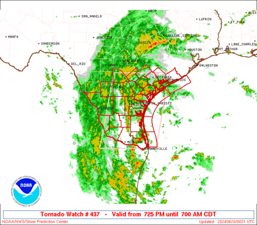
URGENT - IMMEDIATE BROADCAST REQUESTED
Severe Thunderstorm Watch Number 437
NWS Storm Prediction Center Norman OK
1245 PM CDT Thu Jul 2 2026

The NWS Storm Prediction Center has issued a

* Severe Thunderstorm Watch for portions of
  Northeast Iowa
  Southwest Wisconsin

* Effective this Thursday afternoon and evening from 1245 PM
  until 700 PM CDT.

* Primary threats include...
  Scattered damaging wind gusts to 70 mph likely
  Scattered large hail and isolated very large hail events to 2
    inches in diameter possible
  A tornado or two possible

SUMMARY...Thunderstorms are intensifying over north-central Iowa.
These storms will track eastward along and north of a surface
boundary into a strongly unstable air mass.  Damaging winds and
large hail are possible.

The severe thunderstorm watch area is approximately along and 45
statute miles north and south of a line from 25 miles south of Mason
City IA to 20 miles northeast of Dubuque IA. For a complete
depiction of the watch see the associated watch outline update
(WOUS64 KWNS WOU7).

PRECAUTIONARY/PREPAREDNESS ACTIONS...

REMEMBER...A Severe Thunderstorm Watch means conditions are
favorable for severe thunderstorms in and close to the watch area.
Persons in these areas should be on the lookout for threatening
weather conditions and listen for later statements and possible
warnings. Severe thunderstorms can and occasionally do produce
tornadoes.

&&

AVIATION...A few severe thunderstorms with hail surface and aloft to
2 inches. Extreme turbulence and surface wind gusts to 60 knots. A
few cumulonimbi with maximum tops to 500. Mean storm motion vector
26025.

...Hart
Read morehttps://www.spc.noaa.gov/products/watch/ww0437.html
|
|


CMS The Best Conveyancing solicitors conveyancing quotes throughout the UK
For any webhosting enquiries please email webmaster@aus-city.com
|
|
Forums60
Topics786,013
Posts820,783
Members2,960
| |
Most Online22,463
May 9th, 2026
|
|
|


 - Click image for larger picture.")


