|
|
|
0 members (),
3,950
guests, and
23
robots. |
|
Key:
Admin,
Global Mod,
Mod
|
|
S |
M |
T |
W |
T |
F |
S |
|
|
|
|
|
1
|
2
|
3
|
|
4
|
5
|
6
|
7
|
8
|
9
|
10
|
|
11
|
12
|
13
|
14
|
15
|
16
|
17
|
|
18
|
19
|
20
|
21
|
22
|
23
|
24
|
|
25
|
26
|
27
|
28
|
29
|
30
|
31
|
|
There are no members with birthdays on this day. |
|
|
|
|
|
|
|
|
|
|
SPC MD 67
by Webmaster - Sat 31 Jan 2026 04:51:PM
|
|
|
|
|
|
|
|
|
 SPC Jan 31, 2026 1730 UTC Day 2 Convective Outlook
Webmaster
2 hours ago
SPC Jan 31, 2026 1730 UTC Day 2 Convective Outlook
Webmaster
2 hours ago
SPC Jan 31, 2026 1730 UTC Day 2 Convective OutlookSPC 1730Z Day 2 Outlook 
Day 2 Convective Outlook
NWS Storm Prediction Center Norman OK
1048 AM CST Sat Jan 31 2026

Valid 011200Z - 021200Z

...NO THUNDERSTORM AREAS FORECAST...

...SUMMARY...
Thunderstorm potential appears low on Sunday.

...Synopsis...
A large and powerful cyclone initially offshore of the Carolina
coast will move northeastward over the western Atlantic on Sunday,
with cold, dry, and stable conditions expected in its wake across
the eastern CONUS. Elsewhere, a low-amplitude midlevel shortwave
trough will move across the Pacific Northwest early in the period.
Cold temperatures aloft and very weak buoyancy will accompany this
system, and very isolated/sporadic lightning flashes cannot be ruled
out, but it currently appears that convection will be too
weak/shallow for a more substantial thunderstorm threat.

..Dean.. 01/31/2026
Read morehttps://www.spc.noaa.gov/products/outlook/day2otlk_1730.html
0
10
Read More
|
SPC MD 67
Webmaster
2 hours ago
SPC MD 67MD 0067 CONCERNING HEAVY SNOW FOR PIEDMONT OF UPSTATE SOUTH CAROLINA INTO NORTH CAROLINA 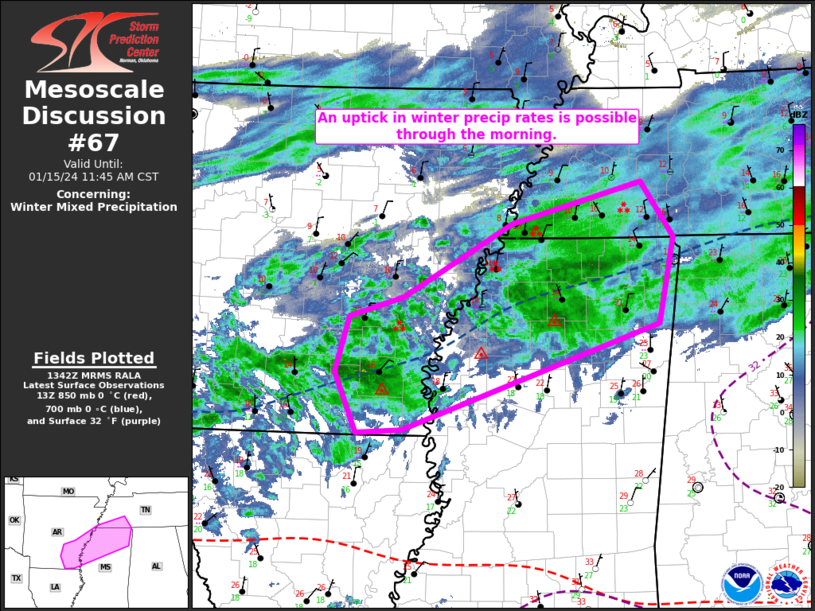
Mesoscale Discussion 0067
NWS Storm Prediction Center Norman OK
0942 AM CST Sat Jan 31 2026

Areas affected...Piedmont of Upstate South Carolina into North
Carolina

Concerning...Heavy snow

Valid 311542Z - 311945Z

SUMMARY...Heavy hourly snow rates around or in excess of 1 inch per
hour may become increasingly common across the Carolina Piedmont
vicinity through 1-4 PM EST.

DISCUSSION...To this point, it appears that peak hourly snow rates
within an area of snow spreading across and to the lee of the
southern Appalachians have remained relatively modest.  Precipitable
water across the Piedmont is generally around or below .35 inches,
with lower values to the west/northwest.  Saturating temperature
profiles are well below freezing, but temperatures conducive to
dendritic ice crystal growth appear initially centered around 700
mb, somewhat low and perhaps not most optimal for larger dendritic
ice crystal growth and aggregation.

However, latest model output suggests that the deep, digging
upstream short wave trough/elongated cyclonic circulation will
gradually take on a more neutral orientation while pivoting across
and southwest of the southern Appalachians through 18-21Z.
Increasingly difluent and divergent mid/upper flow to the northeast
of this feature is forecast to contribute to a period of
strengthening upward vertical motion across the Carolina Piedmont.
This may be enhanced by a band of strengthening frontogenetic
forcing in the 800-700 mb layer, where forecast soundings indicate
cooling profiles will contribute to further lowering, but deepening,
of the dendritic growth zone.  As this occurs, high resolution model
output, among other guidance, suggests increasing potential for
hourly snow rates in excess of 1 inch per hour, which may persist,
at least on an off, through much of the afternoon.

..Kerr.. 01/31/2026

...Please see www.spc.noaa.gov for graphic product...

ATTN...WFO...RAH...RNK...CAE...GSP...

LAT...LON   35548200 36768021 35767929 34778073 34438187 35548200
Read morehttps://www.spc.noaa.gov/products/md/md0067.html
0
10
Read More
|
SPC Day 1 Fire Weather Outlook
Webmaster
2 hours ago
SPC Day 1 Fire Weather OutlookSPC Day 1 Fire Weather Outlook 
Day 1 Fire Weather Outlook
NWS Storm Prediction Center Norman OK
1043 AM CST Sat Jan 31 2026

Valid 311700Z - 011200Z

...NO CRITICAL AREAS...

No changes to Day 1 Fire Weather Outlook were needed. Stronger
northwest winds of 15-25 mph associated with a strong cold front
will continue to spread into the FL Peninsula today. Relative
humidity within the dry, post-frontal air mass will fall to around
30 percent this afternoon, concentrated along the southern AL/GA and
FL Panhandle region. High temperatures primarily in the 30s F
coupled with marginal fuel dryness will limit a broader fire weather
threat across the region where dry and breezy conditions align.
However, pockets of drier fuels may support a locally elevated
wildfire spread potential this afternoon across the northern Gulf
Coast.

..Williams.. 01/31/2026

.PREV DISCUSSION... /ISSUED 1139 PM CST Fri Jan 30 2026/

...Synopsis...
A deepening surface low off the Mid-Atlantic coast will drive 15-20
mph surface winds down the Florida Peninsula today. It is possible
that marginal RH reductions may occur along the Florida-Georgia line
(30-35% during the afternoon). However, light precipitation was
observed on Friday which will dampen fuels. Coupled with
temperatures in the 40s F, fire weather concerns will likely remain
minimal. Elsewhere within the CONUS, combinations of cool/cold
temperatures, light winds, and poor fuel receptiveness will preclude
concerns.

...Please see www.spc.noaa.gov/fire for graphic product...
Read morehttps://www.spc.noaa.gov/products/fire_wx/fwdy1.html
0
11
Read More
|
World Earthquake Report for Saturday, 31 January 2026
Webmaster
3 hours ago
World Earthquake Report for Saturday, 31 January 2026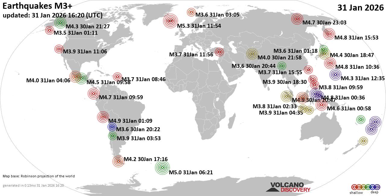 Worldwide earthquakes above magnitude 3 during the past 24 hours on 31 Jan 2026 Magnitude 5+: 2 earthquakes Magnitude 4+: 35 earthquakes Magnitude 3+: 203 earthquakes Magnitude 2+: 389 earthquakes No quakes of magnitude 6 or higher 10 largest earthquakes in the world (past 24 hours)Saturday, Jan 31, 2026, at 11:54 am (Reykjavik time) - Saturday, Jan 31, 2026, at 04:21 am (GMT -2) - Friday, Jan 30, 2026, at 08:09 pm (GMT -5) - Saturday, Jan 31, 2026, at 03:47 am (GMT +7) - Saturday, Jan 31, 2026, at 06:03 am (GMT +7) - Saturday, Jan 31, 2026, at 07:36 pm (GMT +9) - Sunday, Feb 1, 2026, at 03:53 am (GMT +12) - Sunday, Feb 1, 2026, at 04:59 am (GMT +13) - Saturday, Jan 31, 2026, at 08:36 am (GMT +8) - Saturday, Jan 31, 2026, at 10:03 am (GMT +11) - Earthquakes reported feltSaturday, Jan 31, 2026, at 03:58 am (GMT -6) - Friday, Jan 30, 2026, at 10:33 am (GMT -8) - Friday, Jan 30, 2026, at 03:42 pm (GMT -5) - Saturday, Jan 31, 2026, at 01:18 pm (GMT +2) - Saturday, Jan 31, 2026, at 07:44 am (GMT -6) - Friday, Jan 30, 2026, at 05:41 pm (GMT -5) - Saturday, Jan 31, 2026, at 06:03 am (GMT +7) - Friday, Jan 30, 2026, at 10:33 am (GMT -8) - Saturday, Jan 31, 2026, at 03:23 pm (GMT +8) - Saturday, Jan 31, 2026, at 04:32 pm (GMT +7) - Saturday, Jan 31, 2026, at 05:59 pm (GMT +8) - Friday, Jan 30, 2026, at 08:09 pm (GMT -5) - Saturday, Jan 31, 2026, at 02:20 am (GMT -5) - Saturday, Jan 31, 2026, at 03:47 am (GMT +7) - Earthquake stats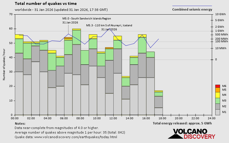 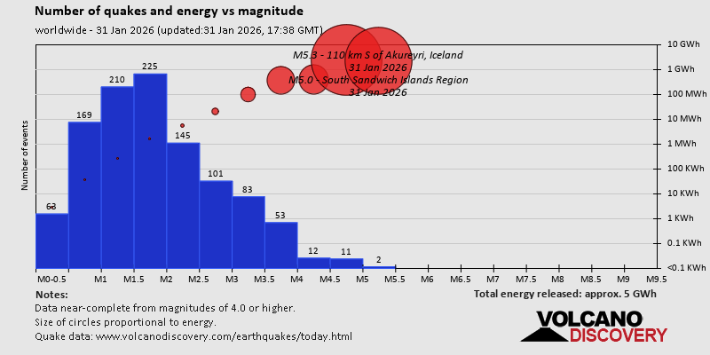 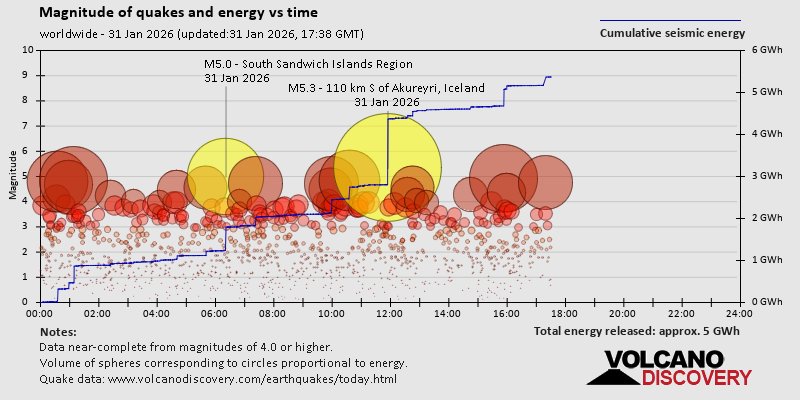 https://www.volcanodiscovery.com/earthquake/news/293479/World-Earthquake-Report-for-Saturday-31-January-2026.html https://www.volcanodiscovery.com/earthquake/news/293479/World-Earthquake-Report-for-Saturday-31-January-2026.html
0
11
Read More
|
SPC Jan 31, 2026 1630 UTC Day 1 Convective Outlook
Webmaster
3 hours ago
SPC Jan 31, 2026 1630 UTC Day 1 Convective OutlookSPC 1630Z Day 1 Outlook 
Day 1 Convective Outlook
NWS Storm Prediction Center Norman OK
1000 AM CST Sat Jan 31 2026

Valid 311630Z - 011200Z

...NO THUNDERSTORM AREAS FORECAST...

...SUMMARY...
Thunderstorms are not forecast across the U.S. through tonight.

...Synopsis and Discussion...
An upper trough/low over the lower OH and TN Valleys late this
morning will pivot eastward over GA/the Carolinas into the western
Atlantic through tonight. Further deepening of a surface low over
the Gulf Stream east of the NC Outer Banks is forecast through the
period, but any associated thunderstorms are expected to remain
offshore. A separate upper trough with related cool mid-level
temperatures will approach the coastal Pacific Northwest late
tonight into early Sunday morning. However, NAM/RAP forecast
soundings suggest minimal MUCAPE will be detrimental to
lightning-producing convection.

..Gleason/Supinie.. 01/31/2026
Read morehttps://www.spc.noaa.gov/products/outlook/day1otlk_1630.html
0
11
Read More
|
Volcano earthquake report for Saturday, 31 Jan 2026
Webmaster
3 hours ago
Volcano earthquake report for Saturday, 31 Jan 2026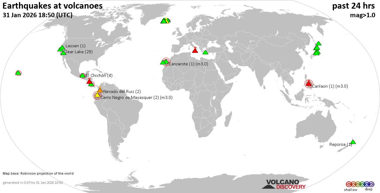 World map showing volcanoes with shallow (less than 50 km) earthquakes within 20 km radius during the past 24 hours on 31 Jan 2026 Number in brackets indicate nr of quakes. Quakes detected near: Bardarbunga (24 quakes between mag 0.1-2.5), Barva (1 quake mag 2.6), Brennisteinsfjöll (2 quakes between mag 1.1-1.2), Canlaon (1 quake mag 3.0), Cerro Negro de Mayasquer (2 quakes between mag 3.0-3.0), Clear Lake (26 quakes between mag 0.2-2.3)
Coso (3 quakes between mag 0.6-1.0), El Chichón (6 quakes between mag 1.6-2.4), Eldey (2 quakes between mag 1.7-1.8), Etna (1 quake mag 1.6), Eyafjallajökull (1 quake mag 3.0), Hiuchi (2 quakes between mag 0.7-1.4), Hrómundartindur (12 quakes between mag 0.2-1.7), Katla (3 quakes between mag 0.5-1.1), Kolumbo (2 quakes between mag 1.8-2.4), Krísuvík (6 quakes between mag 0.1-1.3), Lanzarote (1 quake mag 3.0), Lassen (1 quake mag 2.3), Ljósufjöll (1 quake mag 1.5), Masaya (1 quake mag 2.0), Maunaloa (2 quakes between mag 2.1-2.3), Midagahara (1 quake mag 1.1), Nevado del Ruiz (2 quakes between mag 1.8-1.9), Nikko-Shirane (1 quake mag 1.7), Ontake-san (2 quakes between mag 0.6-1.1), Reporoa (1 quake mag 1.0), Snowy Mountain (1 quake mag 1.3), Tenchozan (1 quake mag 1.9), Tenerife (4 quakes between mag 1.1-1.4), Torfajökull (4 quakes between mag 0.2-1.0), Towada (1 quake mag 3.0), Tungnafellsjökull (1 quake mag 5.3), White Island (2 quakes between mag 2.2-2.6) (updated 15h50)
Note: Earthquakes within 20 km from and at depths less than 50 km under active volcanoes are reported. The list is not complete because many volcanoes are not monitored and/or seismic data in high resolution is not available publicly.
Volcanoes with recent earthquakes above magnitude 2 or more than 10 quakes are listed below:
Bardarbunga volcano (Iceland): 24 earthquakes up to magnitude 2.5Possible earthquake swarm: 24 earthquakes occurred near (under) the volcano during 20 hours, the last being recorded quake 1 hour 43 minutes ago. Hypocenter depths ranged between 7.50 and 0.10 km. Earthquake details: (only 5 largest) 2.5 quake 5.1 km NE of Bárðarbunga Jan 31, 2026 12:25 pm (Universal Time) (6 km NE) 2.2 quake 6.1 km E of Bárðarbunga Jan 31, 2026 12:27 pm (Universal Time) (7 km ENE) 1.8 quake 4.7 km NE of Bárðarbunga Jan 31, 2026 12:23 pm (Universal Time) (6 km NNE) 1.1 quake Iceland: 4.3 km NNE of Bárðarbunga Jan 31, 2026 11:58 am (Reykjavik time) (5 km NNE) 0.9 quake 6.0 km E of Bárðarbunga Jan 31, 2026 02:06 pm (Universal Time) (6 km ENE) All earthquakes at BardarbungaBarva volcano (Costa Rica): magnitude 2.6 earthquakeA magnitude 2.6 earthquake occurred at the volcano 16 hours ago. The quake, which might be volcanic in origin, was located at a depth of 12.00 km depth at 11 km distance ENE from the volcano. Earthquake details: 2.6 quake Provincia de Heredia, 30 km north of San Jose, Provincia de San Jose, Costa Rica, Jan 30, 2026 06:14 pm (GMT -6) (11 km ENE) All earthquakes at BarvaCanlaon volcano (Central Philippines): magnitude 3.0 earthquakeA magnitude 3.0 earthquake occurred at the volcano 4 hours ago. The quake, which might be volcanic in origin, was located at a depth of 10.00 km depth at 0 km distance NW from the volcano. Earthquake details: Reported seismic-like event (likely no quake): 4.1 km south of Bacolod City, Philippines, Jan 31, 2026 07:51 pm (GMT +8) (0 km NW) All earthquakes at CanlaonCerro Negro de Mayasquer volcano (Colombia): 2 earthquakes up to magnitude 3.02 earthquakes occurred near (under) the volcano at nearly the same time (00:22 UTC). Hypocenter depths ranged between 4.00 and 4.00 km. Earthquake details: 3.0 quake 49 km west of Ipiales, Departamento de Narino, Colombia, Jan 30, 2026 07:22 pm (GMT -5) (18 km NW) 3.0 quake 49 km west of Ipiales, Departamento de Narino, Colombia, Jan 30, 2026 07:22 pm (GMT -5) (18 km NW) All earthquakes at Cerro Negro de MayasquerClear Lake volcano (California): 26 earthquakes up to magnitude 2.3Possible earthquake swarm: 26 earthquakes occurred near (under) the volcano during 17 hours, the last being recorded quake 4 hours ago. Hypocenter depths ranged between 3.99 and 0.46 km. Earthquake details: (only 5 largest) 2.3 quake 27 mi north of Santa Rosa, Sonoma County, California, United States, Jan 30, 2026 12:57 pm (GMT -8) (18 km SSW) 1.4 quake 25 mi north of Santa Rosa, Sonoma County, California, United States, Jan 30, 2026 12:56 pm (GMT -8) (19 km S) 1.3 quake Lake County, 27 mi north of Santa Rosa, Sonoma County, California, United States, Jan 30, 2026 10:26 am (GMT -8) (15 km S) 1.3 quake 27 mi north of Santa Rosa, Sonoma County, California, United States, Jan 30, 2026 03:26 pm (GMT -8) (16 km SSW) 1.2 quake 25 mi north of Santa Rosa, Sonoma County, California, United States, Jan 30, 2026 02:41 pm (GMT -8) (19 km S) All earthquakes at Clear LakeEl Chichón volcano (Southern Mexico): 6 earthquakes up to magnitude 2.46 earthquakes occurred near (under) the volcano during 17 hours, the last being recorded quake 5 hours ago. Hypocenter depths ranged between 3.10 and 3.00 km. Earthquake details: (only 5 largest) 2.4 quake Estado de Chiapas, 39 km southwest of Teapa, Estado de Tabasco, Mexico, Jan 30, 2026 08:57 pm (GMT -6) (4 km S) 2.3 quake Estado de Chiapas, 35 km southwest of Teapa, Estado de Tabasco, Mexico, Jan 30, 2026 11:19 am (GMT -6) (2 km N) 2.0 quake Estado de Chiapas, 38 km southwest of Teapa, Estado de Tabasco, Mexico, Jan 31, 2026 04:34 am (GMT -6) (1 km SW) 2.0 quake Estado de Chiapas, 37 km southwest of Teapa, Estado de Tabasco, Mexico, Jan 30, 2026 11:18 am (GMT -6) (1 km NW) 2.0 quake Estado de Chiapas, 37 km southwest of Teapa, Estado de Tabasco, Mexico, Jan 30, 2026 04:33 pm (GMT -6) (1 km NNW) All earthquakes at El ChichónEyafjallajökull volcano (Iceland): magnitude 3.0 earthquakeA magnitude 3.0 earthquake occurred at the volcano 4 hours ago. The quake, which might be volcanic in origin, was located at a depth of 5.20 km depth at 10 km distance ENE from the volcano. Earthquake details: 3.0 quake 48 km northeast of Vestmannaeyjar, South, Iceland, Jan 31, 2026 11:56 am (Reykjavik time) (10 km ENE) All earthquakes at EyafjallajökullHrómundartindur volcano (Iceland): 12 earthquakes up to magnitude 1.7Possible earthquake swarm: 12 earthquakes occurred near (under) the volcano during 21 hours, the last being recorded quake 1 hour 22 minutes ago. Hypocenter depths ranged between 8.70 and 1.10 km. Earthquake details: (only 5 largest) 1.7 quake 1.5 km NE of Hveragerði Jan 30, 2026 08:46 pm (Universal Time) (7 km SSE) 1.1 quake 2.9 km NNE of Hveragerði Jan 31, 2026 05:47 am (Universal Time) (6 km SSE) 0.8 quake 2.3 km W of Þrengsli Jan 31, 2026 01:12 pm (Universal Time) (16 km WSW) 0.8 quake Iceland: 1.0 km SSW of Þrengsli Jan 31, 2026 05:40 am (Reykjavik time) (15 km WSW) 0.7 quake 2.4 km W of Þrengsli Jan 31, 2026 07:56 am (Universal Time) (16 km WSW) All earthquakes at HrómundartindurKolumbo volcano (Greece): 2 earthquakes up to magnitude 2.42 earthquakes occurred near (under) the volcano during 5 hours, the last being recorded quake 12 hours ago. Hypocenter depths ranged between 14.00 and 10.00 km. Earthquake details: 2.4 quake Aegean Sea, 13 km southeast of Nisi Ios Island, Greece, Jan 31, 2026 12:38 am (GMT +2) (13 km NW) 1.8 quake Aegean Sea, 30 km northeast of Santorini Island, Greece, Jan 31, 2026 05:32 am (GMT +2) (15 km NE) All earthquakes at KolumboLanzarote volcano (Canary Islands): magnitude 3.0 earthquakeA magnitude 3.0 earthquake occurred at the volcano 20 hours ago. The quake, which might be volcanic in origin, was located at a depth of 10.00 km depth at 17 km distance SSW from the volcano. Earthquake details: Reported seismic-like event (likely no quake): 27 km southwest of Arrecife, Las Palmas, Canary Islands, Spain, Jan 30, 2026 07:52 pm (GMT +0) (17 km SSW) All earthquakes at LanzaroteLassen volcano (California): magnitude 2.3 earthquakeA magnitude 2.3 earthquake occurred at the volcano 11 hours ago. The quake, which might be volcanic in origin, was located at a depth of 0.61 km depth at 3 km distance SSE from the volcano. Earthquake details: 2.3 quake Shasta County, 17 mi northwest of Chester, Plumas County, California, United States, Jan 30, 2026 09:05 pm (GMT -8) (3 km SSE) All earthquakes at LassenMaunaloa volcano (Hawai'i (Big Island)): 2 earthquakes up to magnitude 2.32 earthquakes occurred near (under) the volcano during 9 minutes, the last being recorded quake 1 hour 50 minutes ago. Hypocenter depths ranged between 0.83 and 0.51 km. Earthquake details: 2.3 quake 33 mi southwest of Hilo, Hawaii County, Hawaii, United States, Jan 31, 2026 03:51 am (GMT -10) (10 km E) 2.1 quake 33 mi southwest of Hilo, Hawaii County, Hawaii, United States, Jan 31, 2026 03:59 am (GMT -10) (10 km E) All earthquakes at MaunaloaTowada volcano (Honshu): magnitude 3.0 earthquakeA magnitude 3.0 earthquake occurred at the volcano 12 hours ago. The quake, which might be volcanic in origin, was located at a depth of 10.00 km depth at 9 km distance NNW from the volcano. Earthquake details: Reported seismic-like event (likely no quake): 33 km southeast of Aomori, Aomori, Japan, Jan 31, 2026 12:56 pm (GMT +9) (9 km NNW) All earthquakes at TowadaTungnafellsjökull volcano (Iceland): magnitude 5.3 earthquakeA magnitude 5.3 earthquake occurred at the volcano 4 hours ago. The quake, which might be volcanic in origin, was located at a depth of 10.00 km depth at 7 km distance SE from the volcano. Earthquake details: 5.3 quake Northeast, 205 km east of Reykjavik, Capital Region, Iceland, Jan 31, 2026 11:54 am (Reykjavik time) (7 km SE) All earthquakes at TungnafellsjökullWhite Island volcano (New Zealand): 2 earthquakes up to magnitude 2.62 earthquakes occurred near (under) the volcano during 51 minutes, the last being recorded quake 22 hours ago. Hypocenter depths ranged between 5.00 and 5.00 km. Earthquake details: 2.6 quake South Pacific Ocean, 36 km north of Whakatane, Bay of Plenty, New Zealand, Jan 31, 2026 05:40 am (GMT +13) (16 km SSW) 2.2 quake South Pacific Ocean, 36 km north of Whakatane, Bay of Plenty, New Zealand, Jan 31, 2026 06:31 am (GMT +13) (15 km SSW) All earthquakes at White Islandhttps://www.volcanodiscovery.com/earthquakes-volcanoes/news/293470/Volcano-earthquake-report-for-Saturday-31-Jan-2026.html
0
9
Read More
|
SPC Jan 31, 2026 1300 UTC Day 1 Convective Outlook
Webmaster
7 hours ago
SPC Jan 31, 2026 1300 UTC Day 1 Convective OutlookSPC 1300Z Day 1 Outlook
Day 1 Convective Outlook
NWS Storm Prediction Center Norman OK
0619 AM CST Sat Jan 31 2026

Valid 311300Z - 011200Z

...NO THUNDERSTORM AREAS FORECAST...

...SUMMARY...
Thunderstorms are not forecast across the U.S. today through
tonight.

Another quiet convective day is forecast across the CONUS today,
with no thunderstorms anticipated.  A deepening surface cyclone off
the Carolina/Georgia coast will aid in the development of
thunderstorms offshore, but that activity is not expected to affect
inland areas.

..Hart.. 01/31/2026
Read morehttps://www.spc.noaa.gov/products/outlook/day1otlk_1300.html
0
5
Read More
|
'Mi, Sunetra Ajit Pawar, pratigya karte ki … ': 'Clock' ticks on in a changed NCP
Webmaster
7 hours ago
With Sunetra Pawar, Ajit Pawar’s wife and a Rajya Sabha member, sworn in as deputy CM on Saturday, stepping into the role held by her husband, the state has formally entered a new and uncertain phase, shaped by the vacuum left by Dada’s death. Sunetra Pawar’s elevation may have filled the immediate constitutional vacuum, but it has also foregrounded larger, unresolved questions about the NCP’s future, the ruling Mahayuti alliance’s stability, and the direction the state’s politics will take in the absence of one of its most influential power brokers. Source: 'Mi, Sunetra Ajit Pawar, pratigya karte ki … ': 'Clock' ticks on in a changed NCP
0
3
Read More
|
Moderate magnitude 4.5 quake hits 45 km southwest of Salina Cruz, Mexico early morning
Webmaster
9 hours ago
Moderate magnitude 4.5 quake hits 45 km southwest of Salina Cruz, Mexico early morning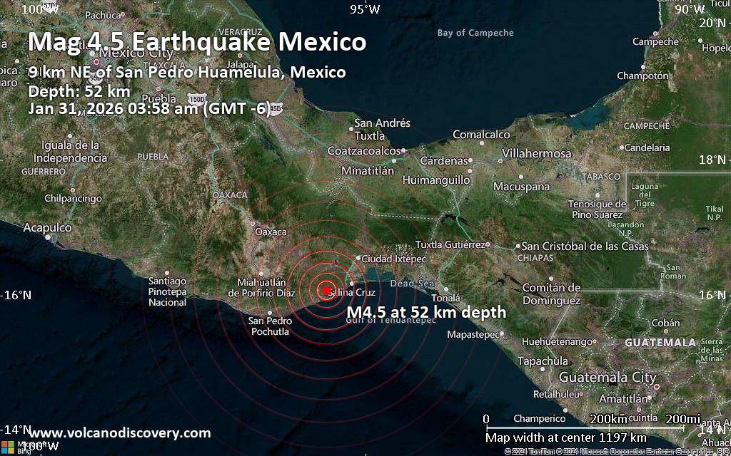 An earthquake of magnitude 4.5 occurred only 23 minutes ago 45 km southwest of Salina Cruz, Mexico, the United States Geological Survey reported.
The quake hit at a moderately shallow depth of 51.92 km beneath the epicenter near Salina Cruz, Estado de Oaxaca, Mexico, early morning on Saturday, January 31st, 2026, at 3:58 am local time. The exact magnitude, epicenter, and depth of the quake might be revised within the next few hours or minutes as seismologists review data and refine their calculations, or as other agencies issue their report.
A second report was later issued by The Incorporated Research Institutions for Seismology (IRIS), which listed it as a magnitude 4.5 earthquake as well. A third agency, the European-Mediterranean Seismological Centre (EMSC), reported the same quake at magnitude 4.5.
Based on the preliminary seismic data, the quake should not have caused any significant damage, but was probably felt by many people as light vibration in the area of the epicenter.
Weak shaking might have been felt in San Francisco de Asis (pop. 85) located 3 km from the epicenter, and San Pedro Huamelula (pop. 2,200) 9 km away.
Other towns or cities near the epicenter where the quake might have been felt as very weak shaking include Salina Cruz (pop. 84,400) located 45 km from the epicenter, Santo Domingo Tehuantepec (pop. 67,700) 47 km away, Heroica Villa de San Blas Atempa (pop. 12,000) 49 km away, Crucecita (pop. 15,100) 67 km away, Juchitan de Zaragoza (pop. 88,300) 74 km away, and Ixtepec (pop. 25,400) 75 km away.
VolcanoDiscovery will automatically update magnitude and depth if these change and follow up if other significant news about the quake become available. If you’re in the area, please send us your experience through our reporting mechanism, either online or via our mobile app. This will help us provide more first-hand updates to anyone around the globe who wants to know more about this quake.
Earthquake data: Date & time: Jan 31, 2026 03:58 am (GMT -6) local time (31 Jan 2026 09:58 GMT)Magnitude: 4.5 Depth: 51.92 km Epicenter latitude / longitude: 16.08°N / 95.6°W  ( San Dionisio del Mar, Estado de Oaxaca, Mexico) Primary data source: USGShttps://www.volcanodiscovery.com/earthquake/news/293502/Moderate-magnitude-45-quake-hits-45-km-southwest-of-Salina-Cruz-Mexico-early-morning-.html
0
8
Read More
|
|
Forums60
Topics759,723
Posts794,439
Members2,958
| |
Most Online17,963
Jan 15th, 2026
|
|
|
|
|
Copyright 1996 - 2026 by David Cottle. Designed by David Bate Jr. All Rights Reserved.
By using this forum, the user agrees not to transfer any data or technical information received under the agreement, to any other entity without the express approval of the AUS-CITY Forum Admins and/or authors of individual posts (Forum Admins and DoD/USSPACECOM for the analysis of satellite tracking data).
Two-line elements (TLE) and all other satellite data presented and distributed via this forum and e-mail lists of AUS-CITY are distributed with permission from DoD/USSTRATCOM.


Reprise Hosting

|

|


 - Click image for larger picture.")


