|
|
|
0 members (),
1,585
guests, and
23
robots. |
|
Key:
Admin,
Global Mod,
Mod
|
|
S |
M |
T |
W |
T |
F |
S |
|
1
|
2
|
3
|
4
|
5
|
6
|
7
|
|
8
|
9
|
10
|
11
|
12
|
13
|
14
|
|
15
|
16
|
17
|
18
|
19
|
20
|
21
|
|
22
|
23
|
24
|
25
|
26
|
27
|
28
|
|
There are no members with birthdays on this day. |
 Volcano earthquake report for Tuesday, 10 Feb 2026
Webmaster
11 hours ago
Volcano earthquake report for Tuesday, 10 Feb 2026
Webmaster
11 hours ago
Volcano earthquake report for Tuesday, 10 Feb 2026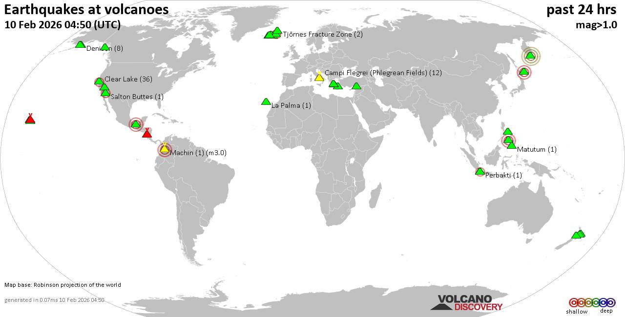 World map showing volcanoes with shallow (less than 50 km) earthquakes within 20 km radius during the past 24 hours on 10 Feb 2026 Number in brackets indicate nr of quakes. Quakes detected near: Akagi (1 quake mag 1.7), Bratan (1 quake mag 2.0), Campi Flegrei (Phlegrean Fields) (6 quakes between mag 0.3-1.4), Clear Lake (31 quakes between mag 0.2-1.8), Coso (3 quakes between mag 0.8-2.1), Cuernos de Negros (1 quake mag 3.0)
Denison (8 quakes between mag 0.0-2.3), Edgecumbe (1 quake mag 1.0), El Chichón (4 quakes between mag 2.3-3.0), Eldey (243 quakes between mag 0.0-3.0), Eyafjallajökull (1 quake mag 1.1), Gagak (1 quake mag 2.1), Gilbanta (1 quake mag 2.3), Hrómundartindur (1 quake mag 2.0), Katla (8 quakes between mag 0.1-1.4), Kilauea (10 quakes between mag 1.3-1.9), Kolumbo (1 quake mag 1.7), Krísuvík (13 quakes between mag 0.0-2.0), La Palma (2 quakes between mag 1.9-1.9), Ljósufjöll (2 quakes between mag 0.6-1.1), Loihi (1 quake mag 1.8), Loki-Fögrufjöll volcano (3 quakes between mag 0.2-2.0), Machin (1 quake mag 3.0), Masaya (2 quakes between mag 1.7-1.8), Matutum (1 quake mag 2.1), Maunaloa (2 quakes between mag 1.8-2.7), Methana (1 quake mag 2.4), Opala (1 quake mag 4.8), Perbakti (1 quake mag 2.1), Reporoa (3 quakes between mag 1.2-1.5), Salton Buttes (1 quake mag 2.0), Sangay (Philippines) (1 quake mag 1.7), Santorini (1 quake mag 1.6), Sousaki (1 quake mag 1.3), Svartsengi (14 quakes between mag 0.0-1.1), Taranaki (1 quake mag 1.7), Taupo (2 quakes between mag 1.5-1.7), Tenchozan (1 quake mag 3.4), Tenerife (5 quakes between mag 0.4-1.6), Tjörnes Fracture Zone (2 quakes between mag 1.3-1.4) (updated 01h50)
Note: Earthquakes within 20 km from and at depths less than 50 km under active volcanoes are reported. The list is not complete because many volcanoes are not monitored and/or seismic data in high resolution is not available publicly.
Volcanoes with recent earthquakes above magnitude 2 or more than 10 quakes are listed below:
Clear Lake volcano (California): 31 earthquakes up to magnitude 1.8Possible earthquake swarm: 31 earthquakes occurred near (under) the volcano during 23 hours, the last being recorded quake 22 minutes ago. Hypocenter depths ranged between 11.74 and 0.37 km. Earthquake details: (only 5 largest) 1.8 quake Sonoma County, 13 mi southwest of Clearlake, Lake County, California, United States, Feb 9, 2026 01:26 pm (GMT -8) (16 km S) 1.8 quake Sonoma County, 14 mi southwest of Clearlake, Lake County, California, United States, Feb 9, 2026 10:01 am (GMT -8) (17 km SSW) 1.6 quake 12 mi southwest of Clearlake, Lake County, California, United States, Feb 9, 2026 05:27 pm (GMT -8) (15 km S) 1.4 quake 27 mi north of Santa Rosa, Sonoma County, California, United States, Feb 9, 2026 03:43 am (GMT -8) (16 km S) 1.2 quake Lake County, 25 mi north of Santa Rosa, Sonoma County, California, United States, Feb 9, 2026 01:57 am (GMT -8) (19 km S) All earthquakes at Clear LakeCoso volcano (California): 3 earthquakes up to magnitude 2.13 earthquakes occurred near (under) the volcano during 8 minutes, the last being recorded quake 11 hours ago. Hypocenter depths ranged between 3.98 and 2.97 km. Earthquake details: 2.1 quake Inyo County, 20 mi north of Ridgecrest, Kern County, California, United States, Feb 9, 2026 06:45 am (GMT -8) (16 km SSE) 1.2 quake Inyo County, 20 mi north of Ridgecrest, Kern County, California, United States, Feb 9, 2026 02:47 pm (Universal Time) (16 km SSE) 0.8 quake Inyo County, 20 mi north of Ridgecrest, Kern County, California, United States, Feb 9, 2026 02:53 pm (Universal Time) (15 km SSE) All earthquakes at CosoCuernos de Negros volcano (Central Philippines): magnitude 3.0 earthquakeA magnitude 3.0 earthquake occurred at the volcano 15 hours ago. The quake, which might be volcanic in origin, was located at a depth of 10.00 km depth at 11 km distance SE from the volcano. Earthquake details: Reported seismic-like event (likely no quake): 16 km southwest of Dumaguete, Philippines, Feb 9, 2026 06:57 pm (GMT +8) (11 km SE) All earthquakes at Cuernos de NegrosDenison volcano (Alaska Peninsula): 8 earthquakes up to magnitude 2.38 earthquakes occurred near (under) the volcano during 1 hour 33 minutes, the last being recorded quake 10 hours ago. Hypocenter depths ranged between 5.00 and 2.50 km. Earthquake details: (only 5 largest) 2.3 quake Lake and Peninsula Borough, 91 mi northwest of Kodiak, Kodiak Island Borough, Alaska, United States, Feb 9, 2026 05:34 am (GMT -9) (8 km WNW) 1.8 quake Lake and Peninsula Borough, 91 mi northwest of Kodiak, Kodiak Island Borough, Alaska, United States, Feb 9, 2026 05:23 am (GMT -9) (8 km WNW) 1.1 quake Lake and Peninsula Borough, 91 mi northwest of Kodiak, Kodiak Island Borough, Alaska, United States, Feb 9, 2026 02:23 pm (Universal Time) (9 km W) 0.9 quake Lake and Peninsula Borough, 90 mi northwest of Kodiak, Kodiak Island Borough, Alaska, United States, Feb 9, 2026 03:27 pm (Universal Time) (6 km W) 0.8 quake Lake and Peninsula Borough, 93 mi northwest of Kodiak, Kodiak Island Borough, Alaska, United States, Feb 9, 2026 02:28 pm (Universal Time) (11 km NW) All earthquakes at DenisonEl Chichón volcano (Southern Mexico): 4 earthquakes up to magnitude 3.04 earthquakes occurred near (under) the volcano during 18 hours, the last being recorded quake 3 hours ago. Hypocenter depths ranged between 3.30 and 2.00 km. Earthquake details: 3.0 quake Estado de Chiapas, 36 km southwest of Teapa, Estado de Tabasco, Mexico, Feb 9, 2026 04:57 pm (GMT -6) (2 km N) 2.6 quake Estado de Chiapas, 37 km southwest of Teapa, Estado de Tabasco, Mexico, Feb 8, 2026 10:57 pm (GMT -6) (0 km WNW) 2.3 quake Estado de Chiapas, 36 km southwest of Teapa, Estado de Tabasco, Mexico, Feb 8, 2026 10:43 pm (GMT -6) (1 km E) 2.3 quake Estado de Chiapas, 38 km southwest of Teapa, Estado de Tabasco, Mexico, Feb 9, 2026 02:00 am (GMT -6) (1 km SSW) All earthquakes at El ChichónEldey volcano (Iceland): 243 earthquakes up to magnitude 3.0Possible earthquake swarm: 243 earthquakes occurred near (under) the volcano during 21 hours, the last being recorded quake 2 hours ago. Hypocenter depths ranged between 25.00 and 0.00 km. Earthquake details: (only 5 largest) 3.0 quake Irminger Sea, 29 km southwest of Keflavik, Southern Peninsula, Iceland, Feb 9, 2026 11:27 am (Reykjavik time) (8 km NE) 2.8 quake Irminger Sea, 33 km southwest of Keflavik, Southern Peninsula, Iceland, Feb 9, 2026 03:58 pm (Reykjavik time) (5 km N) 2.8 quake Irminger Sea, 28 km southwest of Keflavik, Southern Peninsula, Iceland, Feb 9, 2026 04:53 pm (Reykjavik time) (9 km NNE) 2.4 quake 2.7 km NNE of Eldey Feb 9, 2026 07:00 pm (Universal Time) (4 km NE) 2.3 quake 6.2 km N of Eldey Feb 9, 2026 03:07 am (Universal Time) (7 km NNE) All earthquakes at EldeyEldey is located at the beginning of the Reykjanes Ridge off the SW tip of Iceland. Its highest elevation is the top of Eldey Island, but most of the volcanic edifice is submerged. Several eruptions occurred in historic times, last in 1926. Gagak volcano (West Java): magnitude 2.1 earthquakeA magnitude 2.1 earthquake occurred at the volcano 10 hours ago. The quake, which might be volcanic in origin, was located at a depth of 17.00 km depth at 1 km distance NE from the volcano. Earthquake details: 2.1 quake Bogor Regency, 15 km northwest of Cicurug, Indonesia, Feb 9, 2026 11:01 pm (GMT +7) (1 km NE) All earthquakes at GagakGilbanta volcano (Lesser Sunda Islands): magnitude 2.3 earthquakeA magnitude 2.3 earthquake occurred at the volcano 24 hours ago. The quake, which might be volcanic in origin, was located at a depth of 37.00 km depth at 16 km distance ESE from the volcano. Earthquake details: 2.3 quake 48 km west of Labuan Bajo, Indonesia, Feb 9, 2026 10:00 am (GMT +8) (16 km ESE) All earthquakes at GilbantaKrísuvík volcano (Reykjanes Peninsula, Iceland): 13 earthquakes up to magnitude 2.0Possible earthquake swarm: 13 earthquakes occurred near (under) the volcano during 13 hours, the last being recorded quake 10 hours ago. Hypocenter depths ranged between 5.20 and 0.00 km. Earthquake details: (only 5 largest) 2.0 quake 3.9 km E of Keilir Feb 9, 2026 10:39 am (Universal Time) (1 km NNE) 1.4 quake Iceland: 5.5 km ENE of Keilir Feb 9, 2026 06:54 am (Reykjavik time) (3 km NNE) 1.4 quake 5.5 km ENE of Keilir Feb 9, 2026 03:26 am (Universal Time) (4 km NNE) 1.2 quake Iceland: 2.3 km N of Krýsuvík Feb 9, 2026 10:54 am (Reykjavik time) (3 km SSE) 1.0 quake Iceland: 4.0 km E of Keilir Feb 9, 2026 11:46 am (Reykjavik time) (1 km NE) All earthquakes at KrísuvíkMachin volcano (Colombia): magnitude 3.0 earthquakeA magnitude 3.0 earthquake occurred at the volcano 15 hours ago. The quake, which might be volcanic in origin, was located at a depth of 10.00 km depth at 6 km distance SW from the volcano. Earthquake details: Reported seismic-like event (likely no quake): 25 km west of Ibague, Departamento de Tolima, Colombia, Feb 9, 2026 05:57 am (GMT -5) (6 km SW) All earthquakes at MachinMatutum volcano (Mindanao): magnitude 2.1 earthquakeA magnitude 2.1 earthquake occurred at the volcano 10 hours ago. The quake, which might be volcanic in origin, was located at a depth of 28.00 km depth at 11 km distance NE from the volcano. Earthquake details: 2.1 quake Province of Sarangani, 15 km southeast of Lambayong, Philippines, Feb 9, 2026 11:31 pm (GMT +8) (11 km NE) All earthquakes at MatutumMaunaloa volcano (Hawai'i (Big Island)): 2 earthquakes up to magnitude 2.72 earthquakes occurred near (under) the volcano during 4 hours, the last being recorded quake 14 hours ago. Hypocenter depths ranged between 6.55 and 0.32 km. Earthquake details: 2.7 quake 18 mi east of Holualoa, Hawaii County, Hawaii, United States, Feb 8, 2026 08:59 pm (GMT -10) (11 km NW) 1.8 quake 39 mi southwest of Hilo, Hawaii County, Hawaii, United States, Feb 9, 2026 01:27 am (GMT -10) (5 km S) All earthquakes at MaunaloaMethana volcano (Greece): magnitude 2.4 earthquakeA magnitude 2.4 earthquake occurred at the volcano 21 hours ago. The quake, which might be volcanic in origin, was located at a depth of 19.90 km depth at 13 km distance N from the volcano. Earthquake details: 2.4 quake Aegean Sea, 13 km west of Aegina Island, Nomos Attikis, Attica, Greece, Feb 9, 2026 07:04 am (GMT +2) (13 km N) All earthquakes at MethanaOpala volcano (Southern Kamchatka): magnitude 4.8 earthquakeA magnitude 4.8 earthquake occurred at the volcano 19 hours ago. The quake, which might be volcanic in origin, was located at a depth of 46.00 km depth at 13 km distance SE from the volcano. Earthquake details: 4.8 quake Ust'-Bol'sheretskiy Rayon, 83 km southwest of Vilyuchinsk, Yelizovsky District, Kamchatka, Russia, Feb 9, 2026 06:55 pm (Kamchatka time) (13 km SE) All earthquakes at OpalaPerbakti volcano (West Java): magnitude 2.1 earthquakeA magnitude 2.1 earthquake occurred at the volcano 16 hours ago. The quake, which might be volcanic in origin, was located at a depth of 21.00 km depth at 6 km distance SSW from the volcano. Earthquake details: 2.1 quake 13 km west of Cicurug, Kabupaten Sukabumi, Jawa Barat, Indonesia, Feb 9, 2026 04:39 pm (GMT +7) (6 km SSW) All earthquakes at PerbaktiSvartsengi volcano (Reykjanes Peninsula, Iceland): 14 earthquakes up to magnitude 1.1Possible earthquake swarm: 14 earthquakes occurred near (under) the volcano during 19 hours, the last being recorded quake 4 hours ago. Hypocenter depths ranged between 8.40 and 0.00 km. Earthquake details: (only 5 largest) 1.1 quake Iceland: 1.2 km SSW of Hagafell Feb 9, 2026 02:38 am (Reykjavik time) (2 km S) 1.0 quake 5.3 km NE of Reykjanestá Feb 9, 2026 02:25 am (Universal Time) (11 km WSW) 0.9 quake Iceland: 6.9 km SSE of Reykjanestá Feb 9, 2026 10:42 am (Reykjavik time) (18 km SW) 0.8 quake 11.4 km NNW of Reykjanestá Feb 9, 2026 09:34 pm (Universal Time) (19 km W) 0.7 quake Iceland: 7.8 km N of Reykjanestá Feb 9, 2026 07:04 pm (Reykjavik time) (15 km W) All earthquakes at SvartsengiTenchozan volcano (Hokkaido): magnitude 3.4 earthquakeA magnitude 3.4 earthquake occurred at the volcano 33 minutes ago. The quake, which might be volcanic in origin, was located at a depth of 10.00 km depth at 17 km distance SSW from the volcano. Earthquake details: 3.4 quake 29 km north of Shibetsu, Hokkaido, Japan, Feb 10, 2026 10:17 am (GMT +9) (17 km SSW) All earthquakes at Tenchozanhttps://www.volcanodiscovery.com/earthquakes-volcanoes/news/294406/Volcano-earthquake-report-for-Tuesday-10-Feb-2026.html
0
19
Read More
|
Volcano earthquake report for Tuesday, 10 Feb 2026
Webmaster
11 hours ago
Volcano earthquake report for Tuesday, 10 Feb 2026World map showing volcanoes with shallow (less than 50 km) earthquakes within 20 km radius during the past 24 hours on 10 Feb 2026 Number in brackets indicate nr of quakes. Quakes detected near: Akagi (1 quake mag 1.7), Bratan (1 quake mag 2.0), Campi Flegrei (Phlegrean Fields) (6 quakes between mag 0.3-1.4), Clear Lake (31 quakes between mag 0.2-1.8), Coso (3 quakes between mag 0.8-2.1), Cuernos de Negros (1 quake mag 3.0)
Denison (8 quakes between mag 0.0-2.3), Edgecumbe (1 quake mag 1.0), El Chichón (4 quakes between mag 2.3-3.0), Eldey (243 quakes between mag 0.0-3.0), Eyafjallajökull (1 quake mag 1.1), Gagak (1 quake mag 2.1), Gilbanta (1 quake mag 2.3), Hrómundartindur (1 quake mag 2.0), Katla (8 quakes between mag 0.1-1.4), Kilauea (10 quakes between mag 1.3-1.9), Kolumbo (1 quake mag 1.7), Krísuvík (13 quakes between mag 0.0-2.0), La Palma (2 quakes between mag 1.9-1.9), Ljósufjöll (2 quakes between mag 0.6-1.1), Loihi (1 quake mag 1.8), Loki-Fögrufjöll volcano (3 quakes between mag 0.2-2.0), Machin (1 quake mag 3.0), Masaya (2 quakes between mag 1.7-1.8), Matutum (1 quake mag 2.1), Maunaloa (2 quakes between mag 1.8-2.7), Methana (1 quake mag 2.4), Opala (1 quake mag 4.8), Perbakti (1 quake mag 2.1), Reporoa (3 quakes between mag 1.2-1.5), Salton Buttes (1 quake mag 2.0), Sangay (Philippines) (1 quake mag 1.7), Santorini (1 quake mag 1.6), Sousaki (1 quake mag 1.3), Svartsengi (14 quakes between mag 0.0-1.1), Taranaki (1 quake mag 1.7), Taupo (2 quakes between mag 1.5-1.7), Tenchozan (1 quake mag 3.4), Tenerife (5 quakes between mag 0.4-1.6), Tjörnes Fracture Zone (2 quakes between mag 1.3-1.4) (updated 01h50)
Note: Earthquakes within 20 km from and at depths less than 50 km under active volcanoes are reported. The list is not complete because many volcanoes are not monitored and/or seismic data in high resolution is not available publicly.
Volcanoes with recent earthquakes above magnitude 2 or more than 10 quakes are listed below:
Clear Lake volcano (California): 31 earthquakes up to magnitude 1.8Possible earthquake swarm: 31 earthquakes occurred near (under) the volcano during 23 hours, the last being recorded quake 22 minutes ago. Hypocenter depths ranged between 11.74 and 0.37 km. Earthquake details: (only 5 largest) 1.8 quake Sonoma County, 13 mi southwest of Clearlake, Lake County, California, United States, Feb 9, 2026 01:26 pm (GMT -8) (16 km S) 1.8 quake Sonoma County, 14 mi southwest of Clearlake, Lake County, California, United States, Feb 9, 2026 10:01 am (GMT -8) (17 km SSW) 1.6 quake 12 mi southwest of Clearlake, Lake County, California, United States, Feb 9, 2026 05:27 pm (GMT -8) (15 km S) 1.4 quake 27 mi north of Santa Rosa, Sonoma County, California, United States, Feb 9, 2026 03:43 am (GMT -8) (16 km S) 1.2 quake Lake County, 25 mi north of Santa Rosa, Sonoma County, California, United States, Feb 9, 2026 01:57 am (GMT -8) (19 km S) All earthquakes at Clear LakeCoso volcano (California): 3 earthquakes up to magnitude 2.13 earthquakes occurred near (under) the volcano during 8 minutes, the last being recorded quake 11 hours ago. Hypocenter depths ranged between 3.98 and 2.97 km. Earthquake details: 2.1 quake Inyo County, 20 mi north of Ridgecrest, Kern County, California, United States, Feb 9, 2026 06:45 am (GMT -8) (16 km SSE) 1.2 quake Inyo County, 20 mi north of Ridgecrest, Kern County, California, United States, Feb 9, 2026 02:47 pm (Universal Time) (16 km SSE) 0.8 quake Inyo County, 20 mi north of Ridgecrest, Kern County, California, United States, Feb 9, 2026 02:53 pm (Universal Time) (15 km SSE) All earthquakes at CosoCuernos de Negros volcano (Central Philippines): magnitude 3.0 earthquakeA magnitude 3.0 earthquake occurred at the volcano 15 hours ago. The quake, which might be volcanic in origin, was located at a depth of 10.00 km depth at 11 km distance SE from the volcano. Earthquake details: Reported seismic-like event (likely no quake): 16 km southwest of Dumaguete, Philippines, Feb 9, 2026 06:57 pm (GMT +8) (11 km SE) All earthquakes at Cuernos de NegrosDenison volcano (Alaska Peninsula): 8 earthquakes up to magnitude 2.38 earthquakes occurred near (under) the volcano during 1 hour 33 minutes, the last being recorded quake 10 hours ago. Hypocenter depths ranged between 5.00 and 2.50 km. Earthquake details: (only 5 largest) 2.3 quake Lake and Peninsula Borough, 91 mi northwest of Kodiak, Kodiak Island Borough, Alaska, United States, Feb 9, 2026 05:34 am (GMT -9) (8 km WNW) 1.8 quake Lake and Peninsula Borough, 91 mi northwest of Kodiak, Kodiak Island Borough, Alaska, United States, Feb 9, 2026 05:23 am (GMT -9) (8 km WNW) 1.1 quake Lake and Peninsula Borough, 91 mi northwest of Kodiak, Kodiak Island Borough, Alaska, United States, Feb 9, 2026 02:23 pm (Universal Time) (9 km W) 0.9 quake Lake and Peninsula Borough, 90 mi northwest of Kodiak, Kodiak Island Borough, Alaska, United States, Feb 9, 2026 03:27 pm (Universal Time) (6 km W) 0.8 quake Lake and Peninsula Borough, 93 mi northwest of Kodiak, Kodiak Island Borough, Alaska, United States, Feb 9, 2026 02:28 pm (Universal Time) (11 km NW) All earthquakes at DenisonEl Chichón volcano (Southern Mexico): 4 earthquakes up to magnitude 3.04 earthquakes occurred near (under) the volcano during 18 hours, the last being recorded quake 3 hours ago. Hypocenter depths ranged between 3.30 and 2.00 km. Earthquake details: 3.0 quake Estado de Chiapas, 36 km southwest of Teapa, Estado de Tabasco, Mexico, Feb 9, 2026 04:57 pm (GMT -6) (2 km N) 2.6 quake Estado de Chiapas, 37 km southwest of Teapa, Estado de Tabasco, Mexico, Feb 8, 2026 10:57 pm (GMT -6) (0 km WNW) 2.3 quake Estado de Chiapas, 36 km southwest of Teapa, Estado de Tabasco, Mexico, Feb 8, 2026 10:43 pm (GMT -6) (1 km E) 2.3 quake Estado de Chiapas, 38 km southwest of Teapa, Estado de Tabasco, Mexico, Feb 9, 2026 02:00 am (GMT -6) (1 km SSW) All earthquakes at El ChichónEldey volcano (Iceland): 243 earthquakes up to magnitude 3.0Possible earthquake swarm: 243 earthquakes occurred near (under) the volcano during 21 hours, the last being recorded quake 2 hours ago. Hypocenter depths ranged between 25.00 and 0.00 km. Earthquake details: (only 5 largest) 3.0 quake Irminger Sea, 29 km southwest of Keflavik, Southern Peninsula, Iceland, Feb 9, 2026 11:27 am (Reykjavik time) (8 km NE) 2.8 quake Irminger Sea, 33 km southwest of Keflavik, Southern Peninsula, Iceland, Feb 9, 2026 03:58 pm (Reykjavik time) (5 km N) 2.8 quake Irminger Sea, 28 km southwest of Keflavik, Southern Peninsula, Iceland, Feb 9, 2026 04:53 pm (Reykjavik time) (9 km NNE) 2.4 quake 2.7 km NNE of Eldey Feb 9, 2026 07:00 pm (Universal Time) (4 km NE) 2.3 quake 6.2 km N of Eldey Feb 9, 2026 03:07 am (Universal Time) (7 km NNE) All earthquakes at EldeyEldey is located at the beginning of the Reykjanes Ridge off the SW tip of Iceland. Its highest elevation is the top of Eldey Island, but most of the volcanic edifice is submerged. Several eruptions occurred in historic times, last in 1926. Gagak volcano (West Java): magnitude 2.1 earthquakeA magnitude 2.1 earthquake occurred at the volcano 10 hours ago. The quake, which might be volcanic in origin, was located at a depth of 17.00 km depth at 1 km distance NE from the volcano. Earthquake details: 2.1 quake Bogor Regency, 15 km northwest of Cicurug, Indonesia, Feb 9, 2026 11:01 pm (GMT +7) (1 km NE) All earthquakes at GagakGilbanta volcano (Lesser Sunda Islands): magnitude 2.3 earthquakeA magnitude 2.3 earthquake occurred at the volcano 24 hours ago. The quake, which might be volcanic in origin, was located at a depth of 37.00 km depth at 16 km distance ESE from the volcano. Earthquake details: 2.3 quake 48 km west of Labuan Bajo, Indonesia, Feb 9, 2026 10:00 am (GMT +8) (16 km ESE) All earthquakes at GilbantaKrísuvík volcano (Reykjanes Peninsula, Iceland): 13 earthquakes up to magnitude 2.0Possible earthquake swarm: 13 earthquakes occurred near (under) the volcano during 13 hours, the last being recorded quake 10 hours ago. Hypocenter depths ranged between 5.20 and 0.00 km. Earthquake details: (only 5 largest) 2.0 quake 3.9 km E of Keilir Feb 9, 2026 10:39 am (Universal Time) (1 km NNE) 1.4 quake Iceland: 5.5 km ENE of Keilir Feb 9, 2026 06:54 am (Reykjavik time) (3 km NNE) 1.4 quake 5.5 km ENE of Keilir Feb 9, 2026 03:26 am (Universal Time) (4 km NNE) 1.2 quake Iceland: 2.3 km N of Krýsuvík Feb 9, 2026 10:54 am (Reykjavik time) (3 km SSE) 1.0 quake Iceland: 4.0 km E of Keilir Feb 9, 2026 11:46 am (Reykjavik time) (1 km NE) All earthquakes at KrísuvíkMachin volcano (Colombia): magnitude 3.0 earthquakeA magnitude 3.0 earthquake occurred at the volcano 15 hours ago. The quake, which might be volcanic in origin, was located at a depth of 10.00 km depth at 6 km distance SW from the volcano. Earthquake details: Reported seismic-like event (likely no quake): 25 km west of Ibague, Departamento de Tolima, Colombia, Feb 9, 2026 05:57 am (GMT -5) (6 km SW) All earthquakes at MachinMatutum volcano (Mindanao): magnitude 2.1 earthquakeA magnitude 2.1 earthquake occurred at the volcano 10 hours ago. The quake, which might be volcanic in origin, was located at a depth of 28.00 km depth at 11 km distance NE from the volcano. Earthquake details: 2.1 quake Province of Sarangani, 15 km southeast of Lambayong, Philippines, Feb 9, 2026 11:31 pm (GMT +8) (11 km NE) All earthquakes at MatutumMaunaloa volcano (Hawai'i (Big Island)): 2 earthquakes up to magnitude 2.72 earthquakes occurred near (under) the volcano during 4 hours, the last being recorded quake 14 hours ago. Hypocenter depths ranged between 6.55 and 0.32 km. Earthquake details: 2.7 quake 18 mi east of Holualoa, Hawaii County, Hawaii, United States, Feb 8, 2026 08:59 pm (GMT -10) (11 km NW) 1.8 quake 39 mi southwest of Hilo, Hawaii County, Hawaii, United States, Feb 9, 2026 01:27 am (GMT -10) (5 km S) All earthquakes at MaunaloaMethana volcano (Greece): magnitude 2.4 earthquakeA magnitude 2.4 earthquake occurred at the volcano 21 hours ago. The quake, which might be volcanic in origin, was located at a depth of 19.90 km depth at 13 km distance N from the volcano. Earthquake details: 2.4 quake Aegean Sea, 13 km west of Aegina Island, Nomos Attikis, Attica, Greece, Feb 9, 2026 07:04 am (GMT +2) (13 km N) All earthquakes at MethanaOpala volcano (Southern Kamchatka): magnitude 4.8 earthquakeA magnitude 4.8 earthquake occurred at the volcano 19 hours ago. The quake, which might be volcanic in origin, was located at a depth of 46.00 km depth at 13 km distance SE from the volcano. Earthquake details: 4.8 quake Ust'-Bol'sheretskiy Rayon, 83 km southwest of Vilyuchinsk, Yelizovsky District, Kamchatka, Russia, Feb 9, 2026 06:55 pm (Kamchatka time) (13 km SE) All earthquakes at OpalaPerbakti volcano (West Java): magnitude 2.1 earthquakeA magnitude 2.1 earthquake occurred at the volcano 16 hours ago. The quake, which might be volcanic in origin, was located at a depth of 21.00 km depth at 6 km distance SSW from the volcano. Earthquake details: 2.1 quake 13 km west of Cicurug, Kabupaten Sukabumi, Jawa Barat, Indonesia, Feb 9, 2026 04:39 pm (GMT +7) (6 km SSW) All earthquakes at PerbaktiSvartsengi volcano (Reykjanes Peninsula, Iceland): 14 earthquakes up to magnitude 1.1Possible earthquake swarm: 14 earthquakes occurred near (under) the volcano during 19 hours, the last being recorded quake 4 hours ago. Hypocenter depths ranged between 8.40 and 0.00 km. Earthquake details: (only 5 largest) 1.1 quake Iceland: 1.2 km SSW of Hagafell Feb 9, 2026 02:38 am (Reykjavik time) (2 km S) 1.0 quake 5.3 km NE of Reykjanestá Feb 9, 2026 02:25 am (Universal Time) (11 km WSW) 0.9 quake Iceland: 6.9 km SSE of Reykjanestá Feb 9, 2026 10:42 am (Reykjavik time) (18 km SW) 0.8 quake 11.4 km NNW of Reykjanestá Feb 9, 2026 09:34 pm (Universal Time) (19 km W) 0.7 quake Iceland: 7.8 km N of Reykjanestá Feb 9, 2026 07:04 pm (Reykjavik time) (15 km W) All earthquakes at SvartsengiTenchozan volcano (Hokkaido): magnitude 3.4 earthquakeA magnitude 3.4 earthquake occurred at the volcano 33 minutes ago. The quake, which might be volcanic in origin, was located at a depth of 10.00 km depth at 17 km distance SSW from the volcano. Earthquake details: 3.4 quake 29 km north of Shibetsu, Hokkaido, Japan, Feb 10, 2026 10:17 am (GMT +9) (17 km SSW) All earthquakes at Tenchozanhttps://www.volcanodiscovery.com/earthquakes-volcanoes/news/294406/Volcano-earthquake-report-for-Tuesday-10-Feb-2026.html
0
19
Read More
|
Magnitude 4.5 earthquake strikes near Kalamansig, Sultan Kudarat, Soccsksargen, Philippines
Webmaster
11 hours ago
Magnitude 4.5 earthquake strikes near Kalamansig, Sultan Kudarat, Soccsksargen, Philippines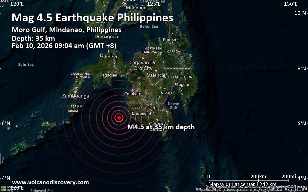 An earthquake of magnitude 4.5 occurred only 11 minutes ago 53 km southwest of Kalamansig, Philippines, the European-Mediterranean Seismological Centre (EMSC) reported.
The quake hit at a moderately shallow depth of 35. km beneath the epicenter near Kalamansig, Sultan Kudarat, Soccsksargen, Philippines, in the morning on Tuesday, February 10th, 2026, at 9:04 am local time. The exact magnitude, epicenter, and depth of the quake might be revised within the next few hours or minutes as seismologists review data and refine their calculations, or as other agencies issue their report.
Our monitoring service identified a second report from Indonesia's Meteorology, Climatology, and Geophysical Agency which listed the quake at magnitude 4.6. A third agency, the citizen-seismograph network of RaspberryShake, reported the same quake at magnitude 4.4.
Based on the preliminary seismic data, the quake should not have caused any significant damage, but was probably felt by many people as light vibration in the area of the epicenter.
Weak shaking might have been felt in Sangay (pop. 3,800) located 44 km from the epicenter, Kulaman (pop. 3,400) 49 km away, Bantogon (pop. 5,400) 50 km away, Palimbang (pop. 4,900) 52 km away, and Kalamansig (pop. 12,800) 53 km away.
Other towns or cities near the epicenter where the quake might have been felt as very weak shaking include Limulan (pop. 3,900) located 56 km from the epicenter, Puloypuloy (pop. 5,100) 63 km away, and Malisbeng (pop. 4,500) 71 km away.
VolcanoDiscovery will automatically update magnitude and depth if these change and follow up if other significant news about the quake become available. If you’re in the area, please send us your experience through our reporting mechanism, either online or via our mobile app. This will help us provide more first-hand updates to anyone around the globe who wants to know more about this quake.
Earthquake data: Date & time: Feb 10, 2026 09:04 am (GMT +8) local time (10 Feb 2026 01:04 GMT)Magnitude: 4.5 Depth: 35.00 km Epicenter latitude / longitude: 6.21°N / 123.72°E  ( Soccsksargen, Philippines) Primary data source: EMSChttps://www.volcanodiscovery.com/earthquake/news/294409/Magnitude-45-earthquake-strikes-near-Kalamansig-Sultan-Kudarat-Soccsksargen-Philippines.html
0
20
Read More
|
Magnitude 4.5 earthquake strikes near Kalamansig, Sultan Kudarat, Soccsksargen, Philippines
Webmaster
11 hours ago
Magnitude 4.5 earthquake strikes near Kalamansig, Sultan Kudarat, Soccsksargen, PhilippinesAn earthquake of magnitude 4.5 occurred only 11 minutes ago 53 km southwest of Kalamansig, Philippines, the European-Mediterranean Seismological Centre (EMSC) reported.
The quake hit at a moderately shallow depth of 35. km beneath the epicenter near Kalamansig, Sultan Kudarat, Soccsksargen, Philippines, in the morning on Tuesday, February 10th, 2026, at 9:04 am local time. The exact magnitude, epicenter, and depth of the quake might be revised within the next few hours or minutes as seismologists review data and refine their calculations, or as other agencies issue their report.
Our monitoring service identified a second report from Indonesia's Meteorology, Climatology, and Geophysical Agency which listed the quake at magnitude 4.6. A third agency, the citizen-seismograph network of RaspberryShake, reported the same quake at magnitude 4.4.
Based on the preliminary seismic data, the quake should not have caused any significant damage, but was probably felt by many people as light vibration in the area of the epicenter.
Weak shaking might have been felt in Sangay (pop. 3,800) located 44 km from the epicenter, Kulaman (pop. 3,400) 49 km away, Bantogon (pop. 5,400) 50 km away, Palimbang (pop. 4,900) 52 km away, and Kalamansig (pop. 12,800) 53 km away.
Other towns or cities near the epicenter where the quake might have been felt as very weak shaking include Limulan (pop. 3,900) located 56 km from the epicenter, Puloypuloy (pop. 5,100) 63 km away, and Malisbeng (pop. 4,500) 71 km away.
VolcanoDiscovery will automatically update magnitude and depth if these change and follow up if other significant news about the quake become available. If you’re in the area, please send us your experience through our reporting mechanism, either online or via our mobile app. This will help us provide more first-hand updates to anyone around the globe who wants to know more about this quake.
Earthquake data: Date & time: Feb 10, 2026 09:04 am (GMT +8) local time (10 Feb 2026 01:04 GMT)Magnitude: 4.5 Depth: 35.00 km Epicenter latitude / longitude: 6.21°N / 123.72°E ( Soccsksargen, Philippines) Primary data source: EMSChttps://www.volcanodiscovery.com/earthquake/news/294409/Magnitude-45-earthquake-strikes-near-Kalamansig-Sultan-Kudarat-Soccsksargen-Philippines.html
0
20
Read More
|
|
Forums60
Topics761,140
Posts795,865
Members2,957
| |
Most Online17,963
Jan 15th, 2026
|
|
|
|
|
Copyright 1996 - 2026 by David Cottle. Designed by David Bate Jr. All Rights Reserved.
By using this forum, the user agrees not to transfer any data or technical information received under the agreement, to any other entity without the express approval of the AUS-CITY Forum Admins and/or authors of individual posts (Forum Admins and DoD/USSPACECOM for the analysis of satellite tracking data).
Two-line elements (TLE) and all other satellite data presented and distributed via this forum and e-mail lists of AUS-CITY are distributed with permission from DoD/USSTRATCOM.


Reprise Hosting

|

|


 - Click image for larger picture.")


