|
|
|
0 members (),
1,764
guests, and
23
robots. |
|
Key:
Admin,
Global Mod,
Mod
|
|
S |
M |
T |
W |
T |
F |
S |
|
|
|
|
1
|
2
|
3
|
4
|
|
5
|
6
|
7
|
8
|
9
|
10
|
11
|
|
12
|
13
|
14
|
15
|
16
|
17
|
18
|
|
19
|
20
|
21
|
22
|
23
|
24
|
25
|
|
26
|
27
|
28
|
29
|
30
|
|
|
|
There are no members with birthdays on this day. |
 World Earthquake Report for Thursday, 9 April 2026
Webmaster
7 hours ago
World Earthquake Report for Thursday, 9 April 2026
Webmaster
7 hours ago
World Earthquake Report for Thursday, 9 April 2026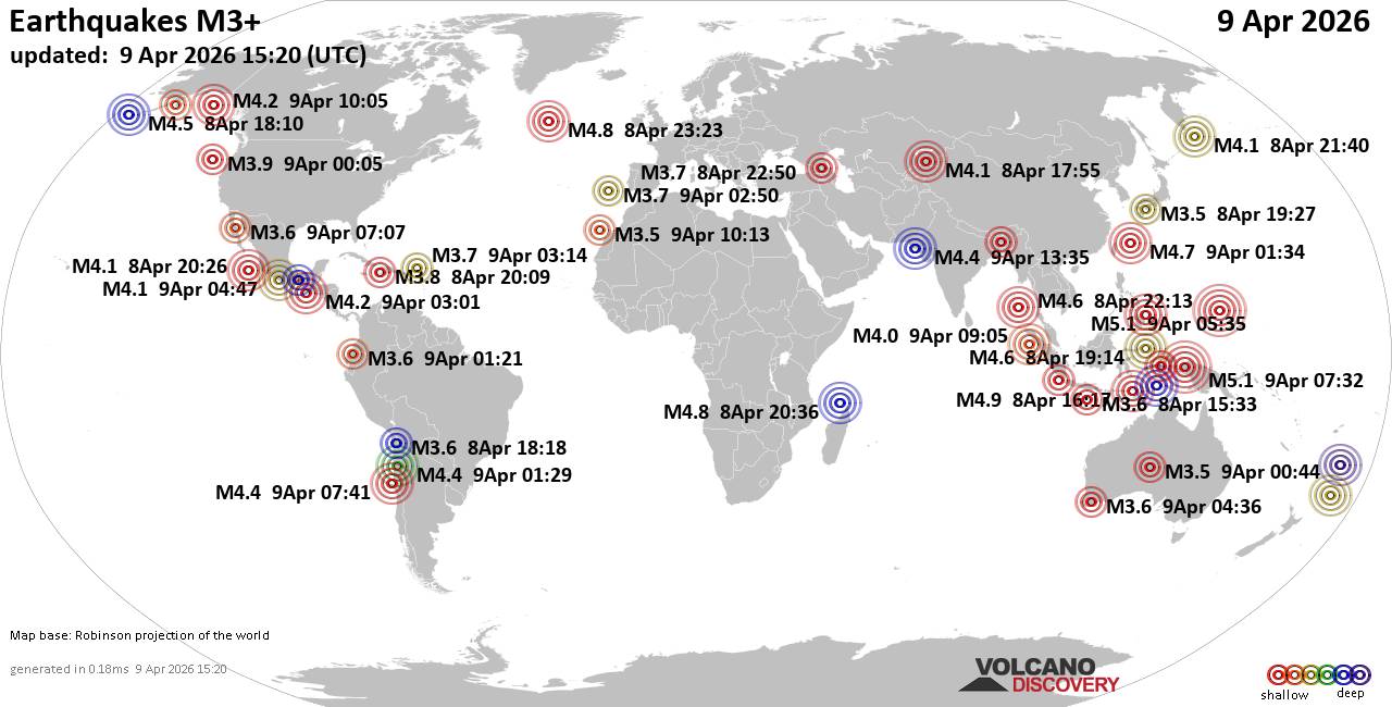 Worldwide earthquakes above magnitude 3 during the past 24 hours on 9 Apr 2026 Magnitude 5+: 2 earthquakes Magnitude 4+: 29 earthquakes Magnitude 3+: 216 earthquakes Magnitude 2+: 385 earthquakes No quakes of magnitude 6 or higher 10 largest earthquakes in the world (past 24 hours)Thursday, Apr 9, 2026, at 04:32 pm (Jayapura time) - Thursday, Apr 9, 2026, at 04:35 pm (GMT +11) - Thursday, Apr 9, 2026, at 01:16 pm (GMT +13) - Thursday, Apr 9, 2026, at 12:17 am (Makassar time) - Thursday, Apr 9, 2026, at 01:36 am (Kerguelen time) - Wednesday, Apr 8, 2026, at 09:23 pm (GMT -2) - Thursday, Apr 9, 2026, at 11:07 pm (Manila time) - Thursday, Apr 9, 2026, at 10:34 am (GMT +9) - Thursday, Apr 9, 2026, at 04:14 am (Jayapura time) - Thursday, Apr 9, 2026, at 03:43 am (GMT +5:30) - Earthquakes reported feltWednesday, Apr 8, 2026, at 09:00 pm (Edmonton time) - Wednesday, Apr 8, 2026, at 11:42 pm (GMT +2) - Thursday, Apr 9, 2026, at 06:44 am (GMT -5) - Wednesday, Apr 8, 2026, at 10:55 pm (Almaty time) - Thursday, Apr 9, 2026, at 11:13 am (GMT +1) - Thursday, Apr 9, 2026, at 11:30 am (GMT +3) - Thursday, Apr 9, 2026, at 12:36 pm (Perth time) - Wednesday, Apr 8, 2026, at 09:44 pm (Istanbul time) - Wednesday, Apr 8, 2026, at 08:51 pm (Guayaquil time) - Wednesday, Apr 8, 2026, at 09:29 pm (Santiago time) - Thursday, Apr 9, 2026, at 12:34 am (GMT +8) - Thursday, Apr 9, 2026, at 11:07 pm (Manila time) - Thursday, Apr 9, 2026, at 12:23 am (Makassar time) - Wednesday, Apr 8, 2026, at 06:50 pm (Guatemala time) - Earthquake stats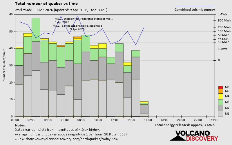 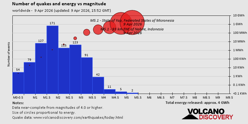  https://www.volcanodiscovery.com/earthquake/news/299582/World-Earthquake-Report-for-Thursday-9-April-2026.html https://www.volcanodiscovery.com/earthquake/news/299582/World-Earthquake-Report-for-Thursday-9-April-2026.html
0
50
Read More
|
Magnitude 4.7 earthquake strikes near Malita, Davao Occidental, Davao, Philippines
Webmaster
7 hours ago
Magnitude 4.7 earthquake strikes near Malita, Davao Occidental, Davao, Philippines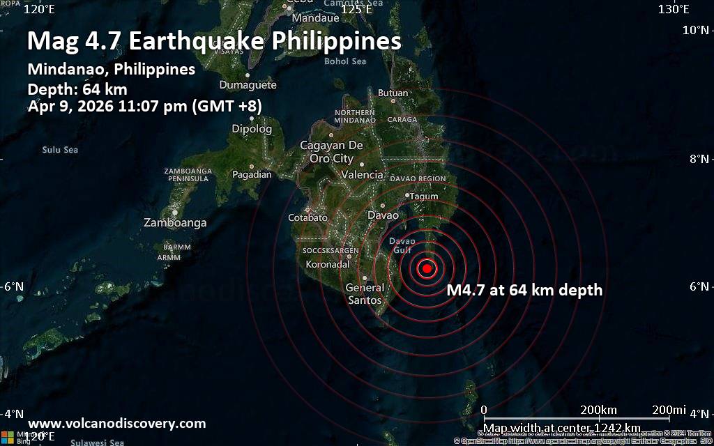 An earthquake of magnitude 4.7 occurred only 8 minutes ago 56 km southeast of Malita, Philippines, Indonesia's Meteorology, Climatology, and Geophysical Agency reported.
The quake hit at a moderately shallow depth of 64. km beneath the epicenter near Malita, Davao Occidental, Davao, Philippines, late at night on Thursday, April 9th, 2026, at 11:07 pm local time. The exact magnitude, epicenter, and depth of the quake might be revised within the next few hours or minutes as seismologists review data and refine their calculations, or as other agencies issue their report.
A second report was later issued by the German Research Centre for Geosciences (GFZ), which listed it as a magnitude 4.7 earthquake as well.
Based on the preliminary seismic data, the quake should not have caused any significant damage, but was probably felt by many people as light vibration in the area of the epicenter.
Weak shaking might have been felt in Nangan (pop. 3,400) located 21 km from the epicenter.
Other towns or cities near the epicenter where the quake might have been felt as very weak shaking include Malita (pop. 118,400) located 56 km from the epicenter, Lupon (pop. 68,700) 68 km away, Mati (pop. 105,900) 75 km away, Alabel (pop. 90,100) 92 km away, Malapatan (pop. 82,600) 97 km away, Digos (pop. 116,100) 97 km away, Samal (pop. 43,500) 97 km away, Davao City (pop. 1,848,900) 102 km away, and General Santos (pop. 722,100) 104 km away.
VolcanoDiscovery will automatically update magnitude and depth if these change and follow up if other significant news about the quake become available. If you’re in the area, please send us your experience through our reporting mechanism, either online or via our mobile app. This will help us provide more first-hand updates to anyone around the globe who wants to know more about this quake.
Earthquake data: Date & time: Apr 9, 2026 11:07 pm (Manila time) local time (9 Apr 2026 15:07 GMT)Magnitude: 4.7 Depth: 64.00 km Epicenter latitude / longitude: 6.29°N / 126.1°E  (Davao Oriental, Davao, Philippines) Primary data source: BMKGhttps://www.volcanodiscovery.com/earthquake/news/299616/Magnitude-47-earthquake-strikes-near-Malita-Davao-Occidental-Davao-Philippines.html
0
80
Read More
|
Volcano earthquake report for Thursday, 9 Apr 2026
Webmaster
7 hours ago
Volcano earthquake report for Thursday, 9 Apr 2026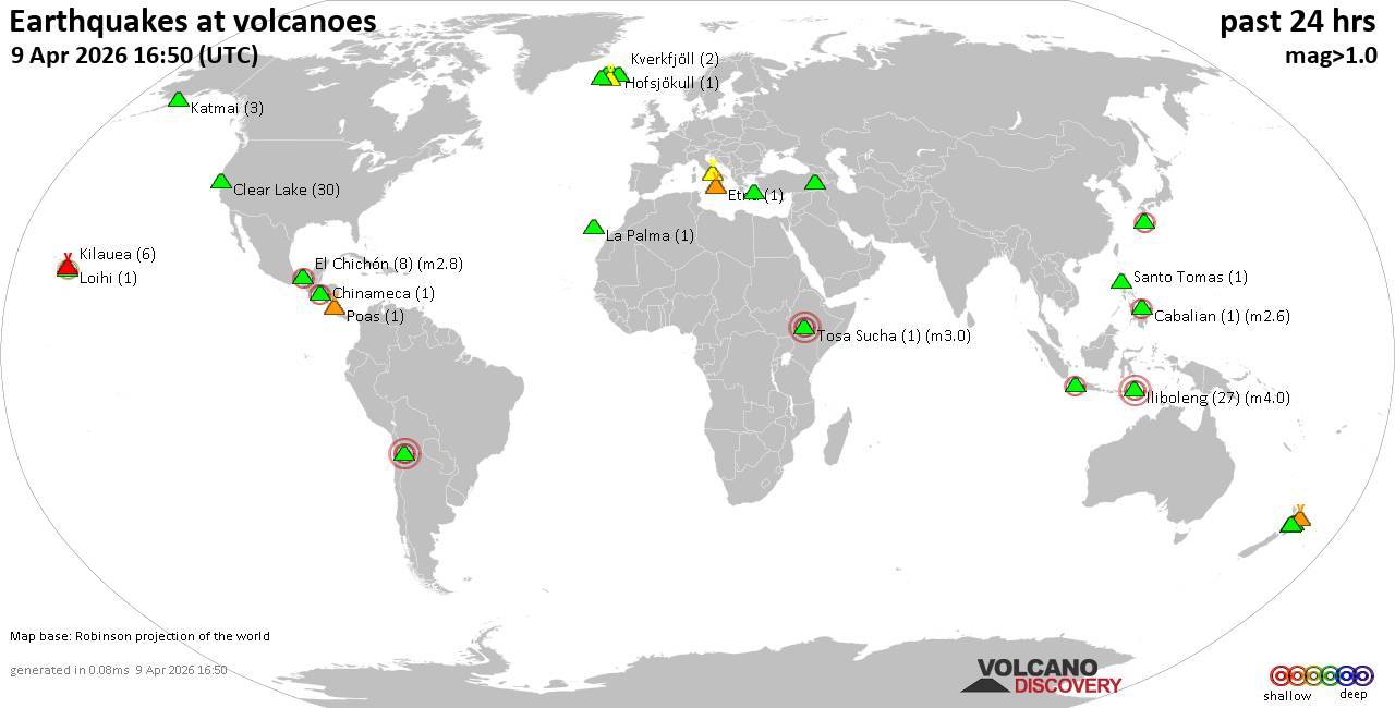 World map showing volcanoes with shallow (less than 50 km) earthquakes within 20 km radius during the past 24 hours on 9 Apr 2026 Number in brackets indicate nr of quakes. Quakes detected near: Bardarbunga (8 quakes between mag 0.2-1.0), Binuluan (1 quake mag 2.1), Cabalian (2 quakes between mag 2.6-3.3), Campi Flegrei (Phlegrean Fields) (29 quakes between mag 0.1-1.3), Chinameca (1 quake mag 2.2), Clear Lake (31 quakes between mag 0.2-1.8)
El Chichón (8 quakes between mag 2.3-2.8), Etna (1 quake mag 1.3), Guayaques (1 quake mag 3.0), Hofsjökull (1 quake mag 1.2), Iliboleng (32 quakes between mag 2.1-4.0), Katla (11 quakes between mag 0.1-1.2), Katmai (3 quakes between mag 0.5-1.5), Kilauea (5 quakes between mag 1.7-2.2), Kolumbo (1 quake mag 1.5), Krísuvík (3 quakes between mag 0.2-1.0), Kuchinoshima (1 quake mag 2.6), La Palma (1 quake mag 1.7), Loihi (1 quake mag 2.4), Prestahnukur (2 quakes between mag 1.2-1.9), Ruapehu (2 quakes between mag 1.1-1.2), Santo Tomas (1 quake mag 1.6), Süphan Dağ (2 quakes between mag 1.7-2.0), Taupo (1 quake mag 1.7), Tongariro (1 quake mag 1.1), Tosa Sucha (1 quake mag 3.0), Whale Island (1 quake mag 2.1) (updated 14h50)
Note: Earthquakes within 20 km from and at depths less than 50 km under active volcanoes are reported. The list is not complete because many volcanoes are not monitored and/or seismic data in high resolution is not available publicly.
Volcanoes with recent earthquakes above magnitude 2 or more than 10 quakes are listed below:
Binuluan volcano (Luzon Island): magnitude 2.1 earthquakeA magnitude 2.1 earthquake occurred at the volcano 22 hours ago. The quake, which might be volcanic in origin, was located at a depth of 11.00 km depth at 10 km distance W from the volcano. Earthquake details: 2.1 quake 32 km west of Tabuk, Kalinga, Cordillera Administrative Region, Philippines, Apr 9, 2026 01:09 am (GMT +8) (10 km W) All earthquakes at BinuluanCabalian volcano (Central Philippines): 2 earthquakes up to magnitude 3.32 earthquakes occurred near (under) the volcano during 12 hours, the last being recorded quake 11 hours ago. Hypocenter depths ranged between 2.00 and 2.00 km. Earthquake details: 3.3 quake Philippine Sea, Eastern Visayas, 35 km northwest of San Jose, Philippines, Apr 9, 2026 12:34 am (GMT +8) (12 km ENE) 2.6 quake Province of Southern Leyte, 38 km south of Abuyog, Philippines, Apr 9, 2026 12:15 pm (GMT +8) (19 km NNW) All earthquakes at CabalianCampi Flegrei (Phlegrean Fields) volcano (Italy): 29 earthquakes up to magnitude 1.3Possible earthquake swarm: 29 earthquakes occurred near (under) the volcano during 14 hours, the last being recorded quake 10 hours ago. Hypocenter depths ranged between 2.05 and 0.01 km. Earthquake details: (only 5 largest) 1.3 quake 4.4 km southeast of Pozzuoli, Napoli, Campania, Italy, Apr 9, 2026 03:43 am (GMT +2) (1 km S) 1.1 quake 12 km west of Naples, Napoli, Campania, Italy, Apr 8, 2026 04:51 pm (GMT +2) (1 km SW) 0.9 quake 4.1 km southeast of Pozzuoli, Napoli, Campania, Italy, Apr 8, 2026 05:31 pm (GMT +2) (0 km SW) 0.7 quake 3.8 km southeast of Pozzuoli, Napoli, Campania, Italy, Apr 8, 2026 09:39 pm (GMT +2) (0 km W) 0.5 quake 4.1 km southeast of Pozzuoli, Napoli, Campania, Italy, Apr 8, 2026 05:42 pm (GMT +2) (1 km SSW) All earthquakes at Campi Flegrei (Phlegrean Fields)Chinameca volcano (El Salvador): magnitude 2.2 earthquakeA magnitude 2.2 earthquake occurred at the volcano 4 hours ago. The quake, which might be volcanic in origin, was located at a depth of 6.00 km depth at 6 km distance W from the volcano. Earthquake details: 2.2 quake 15 km northeast of Usulutan, Departamento de Usulutan, El Salvador, Apr 9, 2026 04:44 am (GMT -6) (6 km W) All earthquakes at ChinamecaClear Lake volcano (California): 31 earthquakes up to magnitude 1.8Possible earthquake swarm: 31 earthquakes occurred near (under) the volcano during 23 hours, the last being recorded quake 51 minutes ago. Hypocenter depths ranged between 10.66 and 0.57 km. Earthquake details: (only 5 largest) 1.8 quake Sonoma County, 13 mi southwest of Clearlake, Lake County, California, United States, Apr 8, 2026 09:47 pm (GMT -7) (15 km SSW) 1.5 quake Mendocino County, 13 mi southwest of Clearlake, Lake County, California, United States, Apr 8, 2026 02:20 pm (GMT -7) (13 km SSW) 1.4 quake Lake County, 30 mi north of Santa Rosa, Sonoma County, California, United States, Apr 8, 2026 07:04 pm (GMT -7) (13 km SSW) 1.0 quake 27 mi north of Santa Rosa, Sonoma County, California, United States, Apr 9, 2026 02:41 am (GMT -7) (18 km SSW) 1.0 quake Lake County, 27 mi north of Santa Rosa, Sonoma County, California, United States, Apr 8, 2026 11:39 pm (GMT -7) (15 km S) All earthquakes at Clear LakeEl Chichón volcano (Southern Mexico): 8 earthquakes up to magnitude 2.88 earthquakes occurred near (under) the volcano during 15 hours, the last being recorded quake 6 hours ago. Hypocenter depths ranged between 4.00 and 2.10 km. Earthquake details: (only 5 largest) 2.8 quake Estado de Chiapas, 36 km southwest of Teapa, Estado de Tabasco, Mexico, Apr 8, 2026 10:09 pm (GMT -6) (2 km E) 2.7 quake Estado de Chiapas, 36 km southwest of Teapa, Estado de Tabasco, Mexico, Apr 9, 2026 01:12 am (GMT -6) (1 km N) 2.7 quake Estado de Chiapas, 36 km southwest of Teapa, Estado de Tabasco, Mexico, Apr 9, 2026 02:00 am (GMT -6) (1 km E) 2.7 quake Estado de Chiapas, 38 km southwest of Teapa, Estado de Tabasco, Mexico, Apr 9, 2026 02:40 am (GMT -6) (1 km SSW) 2.5 quake Estado de Chiapas, 36 km southwest of Teapa, Estado de Tabasco, Mexico, Apr 9, 2026 02:20 am (GMT -6) (1 km NNW) All earthquakes at El ChichónGuayaques volcano (Northern Chile, Bolivia and Argentina): magnitude 3.0 earthquakeA magnitude 3.0 earthquake occurred at the volcano 4 hours ago. The quake, which might be volcanic in origin, was located at a depth of 10.00 km depth at 19 km distance NNE from the volcano. Earthquake details: Reported seismic-like event (likely no quake): Bolivia Apr 9, 2026 06:21 am (GMT -4) (19 km NNE) All earthquakes at GuayaquesIliboleng volcano (Lesser Sunda Islands): 32 earthquakes up to magnitude 4.0Possible earthquake swarm: 32 earthquakes occurred near (under) the volcano during 22 hours, the last being recorded quake 20 minutes ago. Hypocenter depths ranged between 14.00 and 2.00 km. Earthquake details: (only 5 largest) 4.0 quake Kabupaten Flores Timur, 31 km west of Lewoleba, Indonesia, Apr 9, 2026 05:54 am (Makassar time) (13 km WSW) 3.7 quake Savu Sea, 11 km south of Pulau Adonara Island, East Nusa Tenggara, Indonesia, Apr 9, 2026 05:53 am (Makassar time) (13 km SW) 3.7 quake Savu Sea, 12 km southwest of Pulau Adonara Island, East Nusa Tenggara, Indonesia, Apr 9, 2026 02:57 am (Makassar time) (17 km WSW) 3.6 quake 30 km west of Lewoleba, Kabupaten Lembata, East Nusa Tenggara, Indonesia, Apr 9, 2026 12:23 am (Makassar time) (14 km WSW) 3.6 quake Kabupaten Flores Timur, 29 km west of Lewoleba, Indonesia, Apr 9, 2026 02:57 am (Makassar time) (13 km SW) All earthquakes at IlibolengKatla volcano (Iceland): 11 earthquakes up to magnitude 1.2Possible earthquake swarm: 11 earthquakes occurred near (under) the volcano during 20 hours, the last being recorded quake 1 hour 6 minutes ago. Hypocenter depths ranged between 22.10 and 0.00 km. Earthquake details: (only 5 largest) 1.2 quake 2.9 km NNW of Hábunga Apr 9, 2026 12:55 pm (Universal Time) (4 km SW) 0.5 quake 3.1 km NNW of Hábunga Apr 9, 2026 12:54 pm (Universal Time) (4 km SW) 0.4 quake 3.3 km N of Hábunga Apr 9, 2026 12:50 pm (Universal Time) (4 km SW) 0.4 quake 6.7 km ENE of Goðabunga Apr 9, 2026 11:38 am (Universal Time) (6 km NW) 0.4 quake Iceland: 2.4 km NW of Hábunga Apr 8, 2026 05:29 pm (Reykjavik time) (5 km SW) All earthquakes at KatlaKilauea volcano (Hawai'i (Big Island)): 5 earthquakes up to magnitude 2.25 earthquakes occurred near (under) the volcano during 15 hours, the last being recorded quake 1 hour 7 minutes ago. Hypocenter depths ranged between 30.34 and 1.03 km. Earthquake details: 2.2 quake 25 mi southwest of Hilo, Hawaii County, Hawaii, United States, Apr 8, 2026 05:26 pm (GMT -10) (12 km NW) 2.1 quake 26 mi south of Hilo, Hawaii County, Hawaii, United States, Apr 8, 2026 12:41 pm (GMT -10) (17 km ESE) 1.8 quake 25 mi southwest of Hilo, Hawaii County, Hawaii, United States, Apr 8, 2026 08:39 pm (GMT -10) (12 km NW) 1.8 quake 29 mi south of Hilo, Hawaii County, Hawaii, United States, Apr 8, 2026 01:36 pm (GMT -10) (14 km SE) 1.7 quake 37 mi southwest of Hilo, Hawaii County, Hawaii, United States, Apr 9, 2026 03:43 am (GMT -10) (19 km SW) All earthquakes at KilaueaKuchinoshima volcano (Ryukyu Islands): magnitude 2.6 earthquakeA magnitude 2.6 earthquake occurred at the volcano 2 hours ago. The quake, which might be volcanic in origin, was located at a depth of 9.40 km depth at 9 km distance ESE from the volcano. Earthquake details: 2.6 quake East China Sea, Kagoshima-ken, 43 km northeast of Suwanose-jima Island, Japan, Apr 9, 2026 09:38 pm (GMT +9) (9 km ESE) All earthquakes at KuchinoshimaLoihi volcano (Hawai'i (Big Island)): magnitude 2.4 earthquakeA magnitude 2.4 earthquake occurred at the volcano 21 hours ago. The quake, which might be volcanic in origin, was located at a depth of 24.94 km depth at 9 km distance ESE from the volcano. Earthquake details: 2.4 quake North Pacific Ocean, 58 mi south of Hilo, Hawaii County, Hawaii, United States, Apr 8, 2026 07:39 am (GMT -10) (9 km ESE) All earthquakes at LoihiTosa Sucha volcano (Ethiopia): magnitude 3.0 earthquakeA magnitude 3.0 earthquake occurred at the volcano 18 hours ago. The quake, which might be volcanic in origin, was located at a depth of 10.00 km depth at 8 km distance NNW from the volcano. Earthquake details: Reported seismic-like event (likely no quake): 3.4 km south of Arba Minch, South Ethiopia Regional State, Ethiopia, Apr 8, 2026 11:40 pm (GMT +3) (8 km NNW) All earthquakes at Tosa SuchaWhale Island volcano (New Zealand): magnitude 2.1 earthquakeA magnitude 2.1 earthquake occurred at the volcano 22 hours ago. The quake, which might be volcanic in origin, was located at a depth of 40.80 km depth at 5 km distance NNE from the volcano. Earthquake details: 2.1 quake South Pacific Ocean, 16 km north of Whakatane, Bay of Plenty, New Zealand, Apr 9, 2026 05:12 am (GMT +12) (5 km NNE) All earthquakes at Whale Islandhttps://www.volcanodiscovery.com/earthquakes-volcanoes/news/299563/Volcano-earthquake-report-for-Thursday-9-Apr-2026.html
0
29
Read More
|
Assembly elections: Kerala, Assam, Puducherry record higher turnout than 2021
Webmaster
7 hours ago
Kerala, Puducherry, and Assam witnessed increased voter turnout in their recent assembly elections compared to 2021. Puducherry recorded the highest at 89.20%, followed by Assam at 85.10%, and Kerala at 77.50%. Senior leaders, including chief ministers, cast their votes across the 126 seats in Assam, 140 in Kerala, and 30 in Puducherry, with vote counting scheduled for May 4. Source: Assembly elections: Kerala, Assam, Puducherry record higher turnout than 2021
0
3
Read More
|
|
Forums60
Topics768,274
Posts803,038
Members2,958
| |
Most Online17,963
Jan 15th, 2026
|
|
|
|
|
Copyright 1996 - 2026 by David Cottle. Designed by David Bate Jr. All Rights Reserved.
By using this forum, the user agrees not to transfer any data or technical information received under the agreement, to any other entity without the express approval of the AUS-CITY Forum Admins and/or authors of individual posts (Forum Admins and DoD/USSPACECOM for the analysis of satellite tracking data).
Two-line elements (TLE) and all other satellite data presented and distributed via this forum and e-mail lists of AUS-CITY are distributed with permission from DoD/USSTRATCOM.


Reprise Hosting

|

|


 - Click image for larger picture.")


