|
|
|
0 members (),
1,173
guests, and
30
robots. |
|
Key:
Admin,
Global Mod,
Mod
|
|
S |
M |
T |
W |
T |
F |
S |
|
|
|
|
|
1
|
2
|
3
|
|
4
|
5
|
6
|
7
|
8
|
9
|
10
|
|
11
|
12
|
13
|
14
|
15
|
16
|
17
|
|
18
|
19
|
20
|
21
|
22
|
23
|
24
|
|
25
|
26
|
27
|
28
|
29
|
30
|
31
|
|
There are no members with birthdays on this day. |
 World Earthquake Report for Wednesday, 28 January 2026
Webmaster
4 hours ago
World Earthquake Report for Wednesday, 28 January 2026
Webmaster
4 hours ago
World Earthquake Report for Wednesday, 28 January 2026 Worldwide earthquakes above magnitude 3 during the past 24 hours on 28 Jan 2026 Magnitude 5+: 19 earthquakes Magnitude 4+: 51 earthquakes Magnitude 3+: 213 earthquakes Magnitude 2+: 457 earthquakes No quakes of magnitude 6 or higher 10 largest earthquakes in the world (past 24 hours)Wednesday, Jan 28, 2026, at 02:47 pm (GMT +8) - Wednesday, Jan 28, 2026, at 04:38 pm (GMT +8) - Wednesday, Jan 28, 2026, at 04:34 pm (GMT +8) - Wednesday, Jan 28, 2026, at 12:58 am (GMT -1) - Wednesday, Jan 28, 2026, at 03:34 pm (GMT +9) - Wednesday, Jan 28, 2026, at 09:41 am (GMT +8) - Wednesday, Jan 28, 2026, at 08:14 pm (GMT +11) - Wednesday, Jan 28, 2026, at 02:31 pm (GMT +8) - Wednesday, Jan 28, 2026, at 01:58 am (GMT -1) - Wednesday, Jan 28, 2026, at 11:24 am (Manila time) - Earthquakes reported feltTuesday, Jan 27, 2026, at 10:59 pm (GMT -5) - Tuesday, Jan 27, 2026, at 04:58 pm (GMT -6) - Wednesday, Jan 28, 2026, at 02:47 pm (GMT +8) - Wednesday, Jan 28, 2026, at 04:34 pm (GMT +8) - Wednesday, Jan 28, 2026, at 04:38 pm (GMT +8) - Tuesday, Jan 27, 2026, at 11:15 pm (GMT +3) - Wednesday, Jan 28, 2026, at 02:31 pm (GMT +8) - Wednesday, Jan 28, 2026, at 09:41 am (GMT +8) - Wednesday, Jan 28, 2026, at 03:47 am (GMT -5) - Tuesday, Jan 27, 2026, at 09:46 pm (GMT -6) - Wednesday, Jan 28, 2026, at 04:48 am (GMT +9) - Wednesday, Jan 28, 2026, at 10:33 pm (GMT +8) - Wednesday, Jan 28, 2026, at 10:23 am (GMT +8) - Wednesday, Jan 28, 2026, at 04:43 pm (Manila time) - Wednesday, Jan 28, 2026, at 09:27 pm (GMT +8) - Tuesday, Jan 27, 2026, at 08:49 pm (GMT -3) - Wednesday, Jan 28, 2026, at 04:39 am (GMT +9) - Wednesday, Jan 28, 2026, at 03:44 pm (GMT +13) - Wednesday, Jan 28, 2026, at 06:06 am (GMT +7) - Wednesday, Jan 28, 2026, at 09:41 pm (GMT +8) - Wednesday, Jan 28, 2026, at 10:34 am (GMT +10) - Tuesday, Jan 27, 2026, at 10:41 pm (GMT -1) - Wednesday, Jan 28, 2026, at 11:24 am (Manila time) - Wednesday, Jan 28, 2026, at 04:04 pm (GMT +8) - Wednesday, Jan 28, 2026, at 08:24 pm (GMT +12) - Wednesday, Jan 28, 2026, at 07:57 pm (GMT +12) - Wednesday, Jan 28, 2026, at 11:58 pm (GMT +8) - Wednesday, Jan 28, 2026, at 08:45 pm (GMT +8) - Tuesday, Jan 27, 2026, at 10:42 pm (GMT -7) - Wednesday, Jan 28, 2026, at 01:38 pm (GMT +8) - Wednesday, Jan 28, 2026, at 01:08 pm (Manila time) - Wednesday, Jan 28, 2026, at 05:24 pm (GMT +8) - Wednesday, Jan 28, 2026, at 08:20 pm (GMT +8) - Wednesday, Jan 28, 2026, at 03:16 am (GMT +8) - Tuesday, Jan 27, 2026, at 03:06 pm (GMT -6) - Wednesday, Jan 28, 2026, at 07:20 am (GMT +8) - Earthquake stats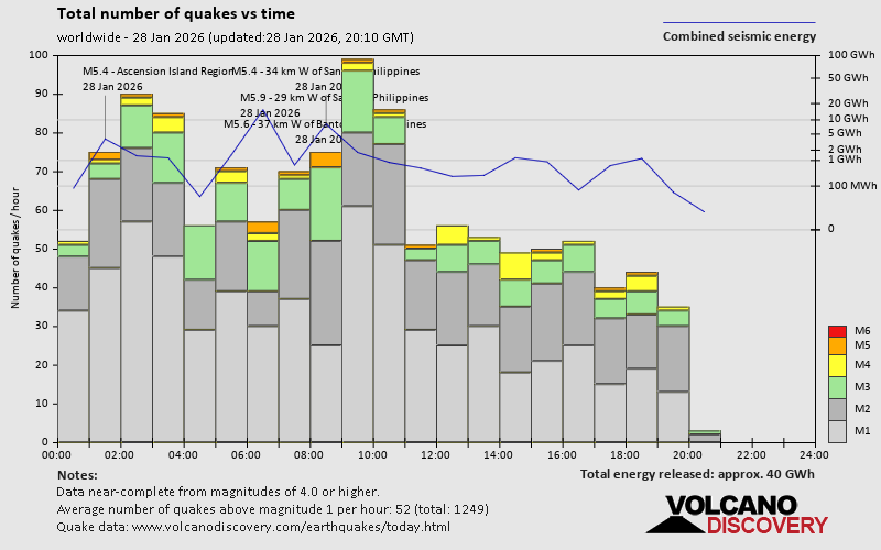 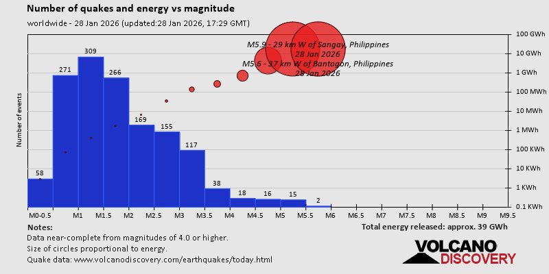 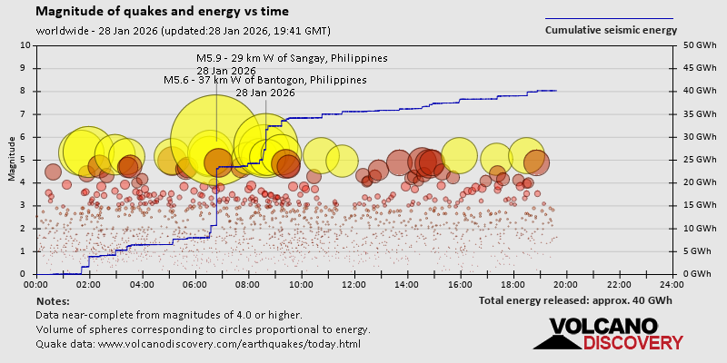 https://www.volcanodiscovery.com/earthquake/news/293156/World-Earthquake-Report-for-Wednesday-28-January-2026.html https://www.volcanodiscovery.com/earthquake/news/293156/World-Earthquake-Report-for-Wednesday-28-January-2026.html
0
15
Read More
|
WEC 2025 BoP analysis: Cadillac
Webmaster
5 hours ago
The Balance of Performance graph for Cadillac tells a clear story: Within just four World Endurance Championship races, the V-Series.R’s power-to-weight ratio deteriorated by 0.171 kg/kW. Not even Ferrari experienced such a drastic shift this season. It was evidence that Cadillac made big steps throughout 2025. This leap was a consequence of both an electronics update over the winter and the ... Keep readingSource: WEC 2025 BoP analysis: Cadillac
0
Read More
|
Volcano earthquake report for Wednesday, 28 Jan 2026
Webmaster
5 hours ago
Volcano earthquake report for Wednesday, 28 Jan 2026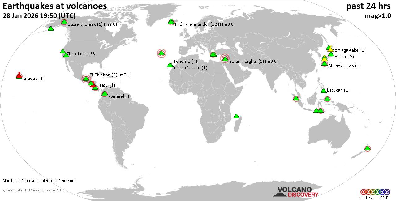 World map showing volcanoes with shallow (less than 50 km) earthquakes within 20 km radius during the past 24 hours on 28 Jan 2026 Number in brackets indicate nr of quakes. Quakes detected near: Abu (5 quakes between mag 0.6-1.0), Akuseki-jima (1 quake mag 2.2), Aso (5 quakes between mag 0.4-1.5), Buzzard Creek (1 quake mag 2.8), Clear Lake (37 quakes between mag 0.4-2.2), Coso (7 quakes between mag 0.8-1.5)
El Chichón (2 quakes between mag 2.1-3.1), Esjufjöll (1 quake mag 1.7), Fajã de Cima (1 quake mag 3.0), Golan Heights (1 quake mag 3.0), Gran Canaria (1 quake mag 1.1), Hiuchi (1 quake mag 1.1), Hrómundartindur (230 quakes between mag 0.3-3.0), Irazu (1 quake mag 2.2), Jailolo (1 quake mag 2.6), Katmai (2 quakes between mag 0.8-1.1), Kilauea (1 quake mag 2.0), Kolumbo (2 quakes between mag 1.5-2.6), Krísuvík (5 quakes between mag 0.1-1.3), Laacher See (1 quake mag 3.0), Laguna Aramuaca (1 quake mag 2.4), Latukan (1 quake mag 1.6), Ljósufjöll (1 quake mag 1.2), Loihi (1 quake mag 1.9), Maroa (1 quake mag 2.4), Masaya (2 quakes between mag 1.3-1.4), Maunaloa (1 quake mag 2.0), Mayotte Island (1 quake mag 1.6), Milos (1 quake mag 2.7), Novarupta (1 quake mag 1.3), Paluweh (1 quake mag 2.3), Romeral (1 quake mag 2.0), San Diego (1 quake mag 1.5), San Pablo (1 quake mag 1.6), Sibualbuali (1 quake mag 2.0), Tambora (2 quakes between mag 2.8-3.3), Tenerife (4 quakes between mag 1.0-1.7), Towada (2 quakes between mag 1.1-1.1), Trident (1 quake mag 1.1) (updated 17h50)
Note: Earthquakes within 20 km from and at depths less than 50 km under active volcanoes are reported. The list is not complete because many volcanoes are not monitored and/or seismic data in high resolution is not available publicly.
Volcanoes with recent earthquakes above magnitude 2 or more than 10 quakes are listed below:
Akuseki-jima volcano (Ryukyu Islands): magnitude 2.2 earthquakeA magnitude 2.2 earthquake occurred at the volcano 5 hours ago. The quake, which might be volcanic in origin, was located at a depth of 12.20 km depth at 15 km distance SSW from the volcano. Earthquake details: 2.2 quake East China Sea, Kagoshima-ken, 38 km southwest of Suwanose-jima Island, Japan, Jan 28, 2026 09:55 pm (GMT +9) (15 km SSW) All earthquakes at Akuseki-jimaBuzzard Creek volcano (Eastern Alaska): magnitude 2.8 earthquakeA magnitude 2.8 earthquake occurred at the volcano 18 hours ago. The quake, which might be volcanic in origin, was located at a depth of 5.00 km depth at 15 km distance W from the volcano. Earthquake details: 2.8 quake 16 mi northeast of Healy, Denali Borough, Alaska, United States, Jan 27, 2026 02:56 pm (GMT -9) (15 km W) All earthquakes at Buzzard CreekClear Lake volcano (California): 37 earthquakes up to magnitude 2.2Possible earthquake swarm: 37 earthquakes occurred near (under) the volcano during 23 hours, the last being recorded quake 13 minutes ago. Hypocenter depths ranged between 11.40 and 0.83 km. Earthquake details: (only 5 largest) 2.2 quake 28 mi north of Santa Rosa, Sonoma County, California, United States, Jan 27, 2026 11:21 am (GMT -8) (18 km SSW) 1.7 quake 13 mi southwest of Clearlake, Lake County, California, United States, Jan 27, 2026 11:28 pm (GMT -8) (16 km S) 1.6 quake 29 mi north of Santa Rosa, Sonoma County, California, United States, Jan 28, 2026 03:00 am (GMT -8) (17 km SW) 1.5 quake 28 mi north of Santa Rosa, Sonoma County, California, United States, Jan 27, 2026 11:27 am (GMT -8) (18 km SSW) 1.4 quake 6 km NW of the Geysers, CA, Jan 27, 2026 06:52 pm (GMT -8) (17 km S) All earthquakes at Clear LakeEl Chichón volcano (Southern Mexico): 2 earthquakes up to magnitude 3.12 earthquakes occurred near (under) the volcano during 7 hours, the last being recorded quake 15 hours ago. Hypocenter depths ranged between 3.70 and 3.00 km. Earthquake details: 3.1 quake Estado de Chiapas, 42 km southwest of Teapa, Estado de Tabasco, Mexico, Jan 27, 2026 09:14 pm (GMT -6) (5 km SW) 2.1 quake Estado de Chiapas, 36 km southwest of Teapa, Estado de Tabasco, Mexico, Jan 27, 2026 02:15 pm (GMT -6) (1 km NNE) All earthquakes at El ChichónFajã de Cima volcano (Azores): magnitude 3.0 earthquakeA magnitude 3.0 earthquake occurred at the volcano 20 hours ago. The quake, which might be volcanic in origin, was located at a depth of 10.00 km depth at 5 km distance SSE from the volcano. Earthquake details: Reported seismic-like event (likely no quake): 0.3 km southeast of Ponta Delgada, Azores, Portugal, Jan 27, 2026 08:34 pm (GMT -1) (5 km SSE) All earthquakes at Fajã de CimaGolan Heights volcano (Syria): magnitude 3.0 earthquakeA magnitude 3.0 earthquake occurred at the volcano 11 hours ago. The quake, which might be volcanic in origin, was located at a depth of 10.00 km depth at 11 km distance NNW from the volcano. Earthquake details: Reported quake or seismic-like event: 6.7 km south of Beirut, Beyrouth, Lebanon, Jan 28, 2026 08:52 am (GMT +2) (11 km NNW) All earthquakes at Golan HeightsHrómundartindur volcano (Iceland): 230 earthquakes up to magnitude 3.0Possible earthquake swarm: 230 earthquakes occurred near (under) the volcano during 23 hours, the last being recorded quake 1 hour 7 minutes ago. Hypocenter depths ranged between 11.30 and 2.30 km. Earthquake details: (only 5 largest) 3.0 quake 24 km southeast of Reykjavik, Capital Region, Iceland, Jan 28, 2026 02:01 am (Reykjavik time) (16 km WSW) 2.6 quake 2.4 km W of Þrengsli Jan 28, 2026 01:59 am (Universal Time) (16 km WSW) 2.5 quake 2.5 km W of Þrengsli Jan 28, 2026 01:42 am (Universal Time) (16 km WSW) 2.3 quake 2.5 km WNW of Þrengsli Jan 28, 2026 02:04 am (Universal Time) (16 km WSW) 2.3 quake 2.4 km W of Þrengsli Jan 28, 2026 09:11 am (Universal Time) (16 km WSW) All earthquakes at HrómundartindurIrazu volcano (Costa Rica): magnitude 2.2 earthquakeA magnitude 2.2 earthquake occurred at the volcano 19 hours ago. The quake, which might be volcanic in origin, was located at a depth of 5.00 km depth at 16 km distance WNW from the volcano. Earthquake details: 2.2 quake 18 km northeast of San Jose, Provincia de San Jose, Costa Rica, Jan 27, 2026 05:05 pm (GMT -6) (16 km WNW) All earthquakes at IrazuJailolo volcano (Halmahera): magnitude 2.6 earthquakeA magnitude 2.6 earthquake occurred at the volcano 14 hours ago. The quake, which might be volcanic in origin, was located at a depth of 4.00 km depth at 4 km distance ESE from the volcano. Earthquake details: 2.6 quake Kabupaten Halmahera Barat, 32 km north of Ternate, Indonesia, Jan 28, 2026 01:03 pm (GMT +9) (4 km ESE) All earthquakes at JailoloKolumbo volcano (Greece): 2 earthquakes up to magnitude 2.62 earthquakes occurred near (under) the volcano during 6 hours, the last being recorded quake 18 hours ago. Hypocenter depths ranged between 10.40 and 5.00 km. Earthquake details: 2.6 quake Aegean Sea, 26 km northeast of Santorini Island, Greece, Jan 27, 2026 07:51 pm (GMT +2) (15 km ENE) 1.5 quake Aegean Sea, 27 km east of Nisi Ios Island, Nomos Kykladon, South Aegean, Greece, Jan 28, 2026 01:31 am (GMT +2) (17 km NE) All earthquakes at KolumboLaacher See volcano (Germany): magnitude 3.0 earthquakeA magnitude 3.0 earthquake occurred at the volcano 22 hours ago. The quake, which might be volcanic in origin, was located at a depth of 10.00 km depth at 9 km distance ESE from the volcano. Earthquake details: Reported seismic-like event (likely no quake): 13 km west of Koblenz, Kreisfreie Stadt Pirmasens, Rheinland-Pfalz, Germany, Jan 27, 2026 08:49 pm (GMT +1) (9 km ESE) All earthquakes at Laacher SeeLaguna Aramuaca volcano (El Salvador): magnitude 2.4 earthquakeA magnitude 2.4 earthquake occurred at the volcano 21 hours ago. The quake, which might be volcanic in origin, was located at a depth of 6.00 km depth at 17 km distance SE from the volcano. Earthquake details: 2.4 quake 16 km west of La Union, Departamento de La Union, El Salvador, Jan 27, 2026 02:21 pm (GMT -6) (17 km SE) All earthquakes at Laguna AramuacaMaroa volcano (New Zealand): magnitude 2.4 earthquakeA magnitude 2.4 earthquake occurred at the volcano 16 hours ago. The quake, which might be volcanic in origin, was located at a depth of 5.00 km depth at 17 km distance SSW from the volcano. Earthquake details: 2.4 quake 17 km northwest of Taupo, Waikato, New Zealand, Jan 28, 2026 02:53 pm (GMT +13) (17 km SSW) All earthquakes at MaroaMilos volcano (Greece): magnitude 2.7 earthquakeA magnitude 2.7 earthquake occurred at the volcano 21 hours ago. The quake, which might be volcanic in origin, was located at a depth of 49.00 km depth at 11 km distance NNE from the volcano. Earthquake details: 2.7 quake 8.4 km northeast of Adamantas, Nomos Kykladon, South Aegean, Greece, Jan 27, 2026 10:39 pm (GMT +2) (11 km NNE) All earthquakes at MilosPaluweh volcano (Lesser Sunda Islands): magnitude 2.3 earthquakeA magnitude 2.3 earthquake occurred at the volcano 13 hours ago. The quake, which might be volcanic in origin, was located at a depth of 2.00 km depth at 16 km distance SE from the volcano. Earthquake details: 2.3 quake Flores Sea, 49 km northwest of Maumere, Indonesia, Jan 28, 2026 01:17 pm (GMT +8) (16 km SE) All earthquakes at PaluwehTambora volcano (Sumbawa): 2 earthquakes up to magnitude 3.32 earthquakes occurred near (under) the volcano during 10 minutes, the last being recorded quake 7 hours ago. Hypocenter depths ranged between 14.00 and 10.00 km. Earthquake details: 3.3 quake Kabupaten Dompu, 52 km east of Sumbawa Besar, Indonesia, Jan 28, 2026 06:35 pm (GMT +8) (18 km WSW) 2.8 quake Kabupaten Dompu, 51 km northeast of Sumbawa Besar, Indonesia, Jan 28, 2026 06:45 pm (GMT +8) (18 km WSW) All earthquakes at Tamborahttps://www.volcanodiscovery.com/earthquakes-volcanoes/news/293139/Volcano-earthquake-report-for-Wednesday-28-Jan-2026.html
0
13
Read More
|
Moderate magnitude 4.8 earthquake 119 km northwest of Saumlaki, Indonesia
Webmaster
5 hours ago
Moderate magnitude 4.8 earthquake 119 km northwest of Saumlaki, Indonesia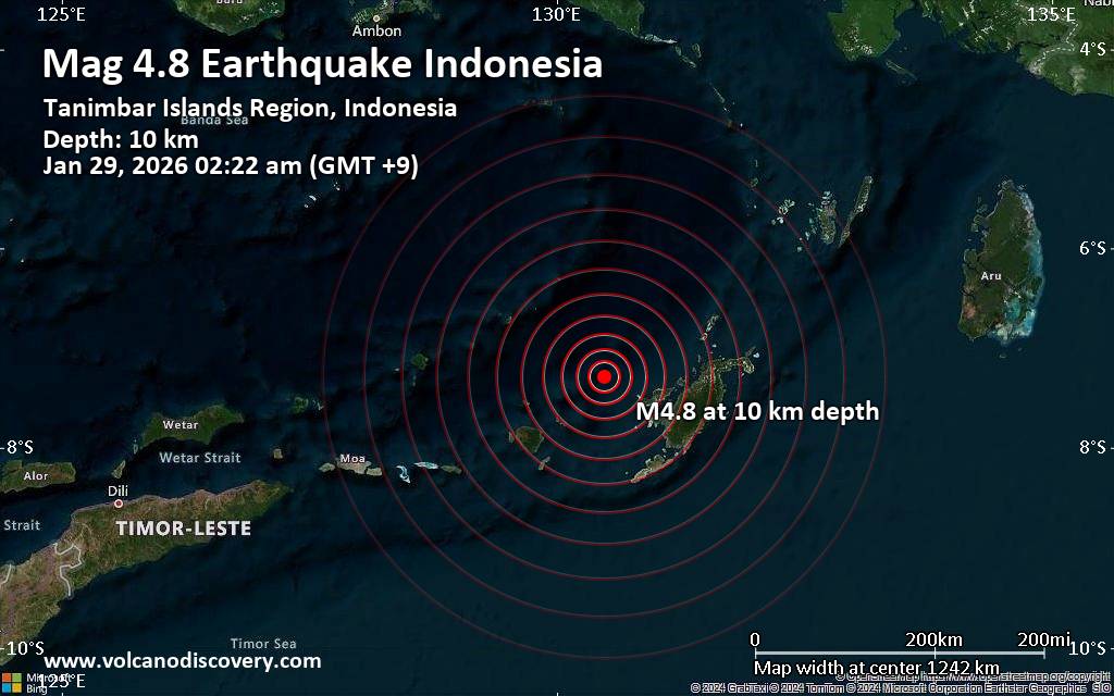 Just 8 minutes ago, a 4.8-magnitude earthquake struck near Saumlaki, Western Southeast Maluku Regency, Maluku, Indonesia. The tremor was recorded early morning on Thursday, January 29th, 2026, at 2:22 am local time, at a shallow depth of 10. km below the surface.
The event was filed by Indonesia's Meteorology, Climatology, and Geophysical Agency, the first seismological agency to report it.
A second report was later issued by the German Research Centre for Geosciences (GFZ), which listed it as a magnitude 4.8 earthquake as well. A third agency, the citizen-seismograph network of RaspberryShake, reported the same quake at magnitude 4.8.
Towns or cities near the epicenter where the quake might have been felt as very weak shaking include Saumlaki (pop. 13,800) located 119 km from the epicenter.
VolcanoDiscovery will automatically update magnitude and depth if these change and follow up if other significant news about the quake become available. If you’re in the area, please send us your experience through our reporting mechanism, either online or via our mobile app. This will help us provide more first-hand updates to anyone around the globe who wants to know more about this quake.
Earthquake data: Date & time: Jan 29, 2026 02:22 am (GMT +9) local time (28 Jan 2026 17:22 GMT)Magnitude: 4.8 Depth: 10.00 km Epicenter latitude / longitude: 7.29°S / 130.48°E  ( Maluku, Indonesia) Primary data source: BMKGhttps://www.volcanodiscovery.com/earthquake/news/293243/Moderate-magnitude-48-earthquake-119-km-northwest-of-Saumlaki-Indonesia.html
0
23
Read More
|
Friday: Light Rain, Minimum Temperature: 5°C (42°F) Maximum Temperature: 9°C (48°F)
Webmaster
6 hours ago
Maximum Temperature: 9°C (48°F), Minimum Temperature: 5°C (42°F), Wind Direction: Easterly, Wind Speed: 9mph, Visibility: Good, Pressure: 989mb, Humidity: 84%, UV Risk: 1, Pollution: Low, Sunrise: 07:58 GMT, Sunset: 16:47 GMT Source: Friday: Light Rain, Minimum Temperature: 5°C (42°F) Maximum Temperature: 9°C (48°F)
0
14
Read More
|
Thursday: Light Cloud, Minimum Temperature: 4°C (39°F) Maximum Temperature: 7°C (45°F)
Webmaster
6 hours ago
Maximum Temperature: 7°C (45°F), Minimum Temperature: 4°C (39°F), Wind Direction: Easterly, Wind Speed: 11mph, Visibility: Good, Pressure: 997mb, Humidity: 83%, UV Risk: 1, Pollution: Low, Sunrise: 08:00 GMT, Sunset: 16:45 GMT Source: Thursday: Light Cloud, Minimum Temperature: 4°C (39°F) Maximum Temperature: 7°C (45°F)
0
14
Read More
|
|
Forums60
Topics759,202
Posts793,917
Members2,958
| |
Most Online17,963
Jan 15th, 2026
|
|
|
|
|
Copyright 1996 - 2026 by David Cottle. Designed by David Bate Jr. All Rights Reserved.
By using this forum, the user agrees not to transfer any data or technical information received under the agreement, to any other entity without the express approval of the AUS-CITY Forum Admins and/or authors of individual posts (Forum Admins and DoD/USSPACECOM for the analysis of satellite tracking data).
Two-line elements (TLE) and all other satellite data presented and distributed via this forum and e-mail lists of AUS-CITY are distributed with permission from DoD/USSTRATCOM.


Reprise Hosting

|

|


 - Click image for larger picture.")


