|
|
|
0 members (),
2,941
guests, and
27
robots. |
|
Key:
Admin,
Global Mod,
Mod
|
|
S |
M |
T |
W |
T |
F |
S |
|
|
|
|
|
|
|
1
|
|
2
|
3
|
4
|
5
|
6
|
7
|
8
|
|
9
|
10
|
11
|
12
|
13
|
14
|
15
|
|
16
|
17
|
18
|
19
|
20
|
21
|
22
|
|
23
|
24
|
25
|
26
|
27
|
28
|
29
|
|
30
|
|
|
|
|
|
|
|
There are no members with birthdays on this day. |
 Moderate yet deep magnitude 5.2 quake hits 40 km northwest of Gueiria, Venezuela in the evening
Webmaster
4 hours ago
Moderate yet deep magnitude 5.2 quake hits 40 km northwest of Gueiria, Venezuela in the evening
Webmaster
4 hours ago
Moderate yet deep magnitude 5.2 quake hits 40 km northwest of Gueiria, Venezuela in the evening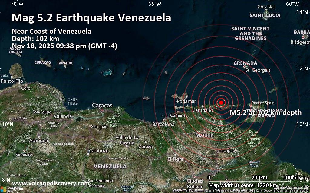 Just 24 minutes ago, a 5.2-magnitude earthquake struck near Gueiria, Valdez Municipality, Sucre, Venezuela. The tremor was recorded in the evening on Tuesday, November 18th, 2025, at 9:38 pm local time, at an intermediate depth of 102. km below the surface.
The event was filed by the German Research Centre for Geosciences (GFZ), the first seismological agency to report it.
A second report was later issued by the citizen-seismograph network of RaspberryShake, which listed it as a magnitude 5.2 earthquake as well. A third agency, The Colombian Geological Service (SGC), reported the same quake at magnitude 5.0.
Based on the preliminary seismic data, the quake should not have caused any significant damage, but was probably felt by many people as light vibration in the area of the epicenter.
Weak shaking might have been felt in Yaguaraparo (pop. 13,600) located 34 km from the epicenter, Gueiria (pop. 40,000) 40 km away, Carupano (pop. 167,200) 73 km away, Caripito (pop. 43,400) 92 km away, Casanay (pop. 20,600) 94 km away, and Port of Spain (pop. 49,000) 119 km away.
VolcanoDiscovery will automatically update magnitude and depth if these change and follow up if other significant news about the quake become available. If you’re in the area, please send us your experience through our reporting mechanism, either online or via our mobile app. This will help us provide more first-hand updates to anyone around the globe who wants to know more about this quake.
Earthquake data: Date & time: Nov 18, 2025 09:38 pm (GMT -4) local time (19 Nov 2025 01:38 GMT)Magnitude: 5.2 Depth: 102.00 km Epicenter latitude / longitude: 10.78°N / 62.6°W  ( Venezuela) Primary data source: GFZhttps://www.volcanodiscovery.com/earthquake/news/287244/Moderate-yet-deep-magnitude-52-quake-hits-40-km-northwest-of-Gueiria-Venezuela-in-the-evening-.html
0
8
Read More
|
Volcano earthquake report for Wednesday, 19 Nov 2025
Webmaster
4 hours ago
Volcano earthquake report for Wednesday, 19 Nov 2025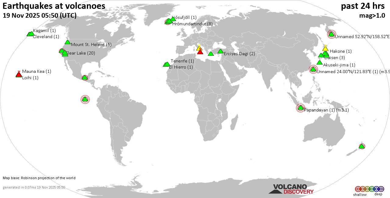 World map showing volcanoes with shallow (less than 50 km) earthquakes within 20 km radius during the past 24 hours on 19 Nov 2025 Number in brackets indicate nr of quakes. Quakes detected near: Akagi (3 quakes between mag 0.5-1.6), Akuseki-jima (1 quake mag 1.8), Barva (1 quake mag 1.7), Campi Flegrei (Phlegrean Fields) (16 quakes between mag 0.1-1.8), Clear Lake (16 quakes between mag 0.6-1.2), Coso (2 quakes between mag 0.9-1.1)
Daisen (3 quakes between mag 0.3-1.2), El Chichón (2 quakes between mag 1.9-2.1), El Hierro (1 quake mag 1.9), Eldey (112 quakes between mag 0.2-2.3), Erciyes Dagi (2 quakes between mag 1.2-1.6), Etna (1 quake mag 1.3), Fagradalsfjall (2 quakes between mag 0.7-1.1), Fernandina (1 quake mag 3.1), Hakone (1 quake mag 2.1), Hiuchi (7 quakes between mag 0.2-1.0), Hrómundartindur (8 quakes between mag 0.4-1.1), Kilauea (3 quakes between mag 1.7-1.8), Kolumbo (3 quakes between mag 1.5-2.0), Ljósufjöll (4 quakes between mag 0.4-2.6), Loihi (1 quake mag 1.7), Loki-Fögrufjöll volcano (3 quakes between mag 0.6-1.7), Mammoth Mountain (1 quake mag 1.2), Mauna Kea (1 quake mag 1.9), Maunaloa (1 quake mag 1.4), Mount St. Helens (5 quakes between mag 0.2-1.2), Nii-jima (1 quake mag 1.7), Niigata-Yake-yama (1 quake mag 3.0), Okmok (1 quake mag 1.0), Prestahnukur (1 quake mag 1.4), Santorini (1 quake mag 1.3), Shishaldin (2 quakes between mag 0.9-1.3), Taupo (1 quake mag 2.2), Tenerife (1 quake mag 1.2), Terceira (1 quake mag 2.2), Tjörnes Fracture Zone (1 quake mag 1.1), Towada (1 quake mag 1.7), Veniaminof (2 quakes between mag 0.2-1.3), Washiba-Kumonotaira (5 quakes between mag 0.2-2.1) (updated 01h50)
Note: Earthquakes within 20 km from and at depths less than 50 km under active volcanoes are reported. The list is not complete because many volcanoes are not monitored and/or seismic data in high resolution is not available publicly.
Volcanoes with recent earthquakes above magnitude 2 or more than 10 quakes are listed below:
Campi Flegrei (Phlegrean Fields) volcano (Italy): 16 earthquakes up to magnitude 1.8Possible earthquake swarm: 16 earthquakes occurred near (under) the volcano during 18 hours, the last being recorded quake 5 hours ago. Hypocenter depths ranged between 3.43 and 0.21 km. Earthquake details: (only 5 largest) 1.8 quake 3.4 km west of Fuorigrotta, Napoli, Campania, Italy, Nov 18, 2025 06:05 am (GMT +1) (2 km E) 1.1 quake 4.1 km southeast of Pozzuoli, Napoli, Campania, Italy, Nov 18, 2025 07:00 am (GMT +1) (0 km SW) 1.1 quake 12 km west of Naples, Napoli, Campania, Italy, Nov 18, 2025 11:53 am (GMT +1) (1 km NW) 1.0 quake 3.8 km west of Fuorigrotta, Napoli, Campania, Italy, Nov 18, 2025 06:10 am (GMT +1) (1 km E) 0.8 quake 4.6 km southeast of Pozzuoli, Napoli, Campania, Italy, Nov 18, 2025 07:08 am (GMT +1) (1 km S) All earthquakes at Campi Flegrei (Phlegrean Fields)Clear Lake volcano (California): 16 earthquakes up to magnitude 1.2Possible earthquake swarm: 16 earthquakes occurred near (under) the volcano during 22 hours, the last being recorded quake 2 hours ago. Hypocenter depths ranged between 3.85 and 0.70 km. Earthquake details: (only 5 largest) 1.2 quake Lake County, 28 mi north of Santa Rosa, Sonoma County, California, United States, Nov 17, 2025 07:37 pm (GMT -8) (15 km S) 1.0 quake Lake County, 25 mi north of Santa Rosa, Sonoma County, California, United States, Nov 18, 2025 03:45 pm (GMT -8) (19 km S) 1.0 quake 25 mi north of Santa Rosa, Sonoma County, California, United States, Nov 18, 2025 07:42 am (GMT -8) (19 km S) 1.0 quake 26 mi north of Santa Rosa, Sonoma County, California, United States, Nov 18, 2025 05:15 am (GMT -8) (18 km SSW) 1.0 quake 26 mi north of Santa Rosa, Sonoma County, California, United States, Nov 18, 2025 03:28 am (GMT -8) (17 km S) All earthquakes at Clear LakeEl Chichón volcano (Southern Mexico): 2 earthquakes up to magnitude 2.12 earthquakes occurred near (under) the volcano during 1 hour 31 minutes, the last being recorded quake 15 hours ago. Hypocenter depths ranged between 5.40 and 4.20 km. Earthquake details: 2.1 quake Estado de Chiapas, 36 km southwest of Teapa, Estado de Tabasco, Mexico, Nov 18, 2025 03:09 am (GMT -6) (1 km SSE) 1.9 quake Estado de Chiapas, 37 km southwest of Teapa, Estado de Tabasco, Mexico, Nov 18, 2025 04:39 am (GMT -6) (1 km SSW) All earthquakes at El ChichónEldey volcano (Iceland): 112 earthquakes up to magnitude 2.3Possible earthquake swarm: 112 earthquakes occurred near (under) the volcano during 21 hours, the last being recorded quake 22 minutes ago. Hypocenter depths ranged between 12.40 and 1.10 km. Earthquake details: (only 5 largest) 2.3 quake Iceland: 5.8 km NE of Eldey Nov 19, 2025 12:33 am (Reykjavik time) (8 km NE) 2.2 quake Iceland: 6.3 km NE of Eldey Nov 19, 2025 12:16 am (Reykjavik time) (8 km NE) 2.2 quake Iceland: 7.3 km W of Reykjanestá Nov 18, 2025 11:51 pm (Reykjavik time) (11 km NE) 2.1 quake Iceland: 6.9 km NE of Eldey Nov 18, 2025 11:34 pm (Reykjavik time) (9 km NE) 2.0 quake Iceland: 7.2 km W of Reykjanestá Nov 18, 2025 11:14 pm (Reykjavik time) (10 km NE) All earthquakes at EldeyEldey is located at the beginning of the Reykjanes Ridge off the SW tip of Iceland. Its highest elevation is the top of Eldey Island, but most of the volcanic edifice is submerged. Several eruptions occurred in historic times, last in 1926. Fernandina volcano (Galapagos Islands): magnitude 3.1 earthquakeA magnitude 3.1 earthquake occurred at the volcano 12 hours ago. The quake, which might be volcanic in origin, was located at a depth of 1.00 km depth at 4 km distance NNE from the volcano. Earthquake details: 3.1 quake 93 km northwest of Puerto Villamil, Provincia de Galapagos, Ecuador, Nov 18, 2025 07:52 am (GMT -6) (4 km NNE) All earthquakes at FernandinaHakone volcano (Honshu): magnitude 2.1 earthquakeA magnitude 2.1 earthquake occurred at the volcano 15 hours ago. The quake, which might be volcanic in origin, was located at a depth of 8.80 km depth at 17 km distance NNE from the volcano. Earthquake details: 2.1 quake 13 km west of Hadano, Kanagawa, Japan, Nov 18, 2025 08:18 pm (GMT +9) (17 km NNE) All earthquakes at HakoneLjósufjöll volcano (Iceland): 4 earthquakes up to magnitude 2.64 earthquakes occurred near (under) the volcano during 17 hours, the last being recorded quake 5 hours ago. Hypocenter depths ranged between 18.10 and 13.10 km. Earthquake details: 2.6 quake 27.5 km N of Borgarnes Nov 18, 2025 04:31 am (Universal Time) (16 km ESE) 1.1 quake Iceland: 27.9 km N of Borgarnes Nov 18, 2025 08:59 pm (Reykjavik time) (18 km ESE) 0.8 quake Iceland: 27.7 km N of Borgarnes Nov 18, 2025 03:38 am (Reykjavik time) (15 km ESE) 0.4 quake Iceland: 28.2 km N of Borgarnes Nov 18, 2025 03:40 am (Reykjavik time) (15 km ESE) All earthquakes at LjósufjöllNiigata-Yake-yama volcano (Honshu): magnitude 3.0 earthquakeA magnitude 3.0 earthquake occurred at the volcano 10 hours ago. The quake, which might be volcanic in origin, was located at a depth of 10.00 km depth at 12 km distance NNW from the volcano. Earthquake details: Reported seismic-like event (likely no quake): 25 km southwest of Joetsu, Niigata, Japan, Nov 19, 2025 12:59 am (GMT +9) (12 km NNW) All earthquakes at Niigata-Yake-yamaTaupo volcano (New Zealand): magnitude 2.2 earthquakeA magnitude 2.2 earthquake occurred at the volcano 5 hours ago. The quake, which might be volcanic in origin, was located at a depth of 6.30 km depth at 19 km distance NNE from the volcano. Earthquake details: 2.2 quake 2.1 km north of Taupo, Waikato, New Zealand, Nov 19, 2025 09:41 am (GMT +13) (19 km NNE) All earthquakes at TaupoTerceira volcano (Azores): magnitude 2.2 earthquakeA magnitude 2.2 earthquake occurred at the volcano 20 hours ago. The quake, which might be volcanic in origin, was located at a depth of 3.30 km depth at 3 km distance ENE from the volcano. Earthquake details: 2.2 quake 12 km northwest of Angra do Heroismo, Azores, Portugal, Nov 18, 2025 04:27 am (GMT -1) (3 km ENE) All earthquakes at TerceiraUnnamed 24.00°N/121.83°E volcano (Taiwan): magnitude 3.9 earthquakeA magnitude 3.9 earthquake occurred at the volcano 49 minutes ago. The quake, which might be volcanic in origin, was located at a depth of 5.50 km depth at 13 km distance NNW from the volcano. Earthquake details: 3.9 quake Philippine Sea, 25 km northeast of Hualien City, Taiwan, Nov 19, 2025 09:01 am (GMT +8) (13 km NNW) All earthquakes at Unnamed 24.00°N/121.83°EUnnamed 52.92°N/158.52°E volcano (Southern Kamchatka): magnitude 3.0 earthquakeA magnitude 3.0 earthquake occurred at the volcano 11 hours ago. The quake, which might be volcanic in origin, was located at a depth of 10.00 km depth at 17 km distance NNE from the volcano. Earthquake details: Reported seismic-like event (likely no quake): 1.9 km southeast of Petropavlovsk-Kamchatskiy, Kamchatka, Russia, Nov 19, 2025 02:30 am (GMT +12) (17 km NNE) All earthquakes at Unnamed 52.92°N/158.52°EWashiba-Kumonotaira volcano (Honshu): 5 earthquakes up to magnitude 2.15 earthquakes occurred near (under) the volcano during 1 hour 38 minutes, the last being recorded quake 21 hours ago. Hypocenter depths ranged between 4.70 and 2.30 km. Earthquake details: 2.1 quake Gifu, 34 km northwest of Matsumoto, Nagano, Japan, Nov 18, 2025 12:56 pm (GMT +9) (7 km SSE) 0.7 quake 33 km northwest of Matsumoto, Nagano, Japan, Nov 18, 2025 01:04 pm (GMT +9) (6 km SSE) 0.6 quake 34 km northwest of Matsumoto, Nagano, Japan, Nov 18, 2025 02:15 pm (GMT +9) (6 km SSE) 0.3 quake 34 km northwest of Matsumoto, Nagano, Japan, Nov 18, 2025 12:37 pm (GMT +9) (6 km SSE) 0.2 quake 34 km northwest of Matsumoto, Nagano, Japan, Nov 18, 2025 01:14 pm (GMT +9) (6 km SSE) All earthquakes at Washiba-Kumonotairahttps://www.volcanodiscovery.com/earthquakes-volcanoes/news/287241/Volcano-earthquake-report-for-Wednesday-19-Nov-2025.html
0
8
Read More
|
SPC Nov 19, 2025 0100 UTC Day 1 Convective Outlook
Webmaster
5 hours ago
SPC Nov 19, 2025 0100 UTC Day 1 Convective OutlookSPC 0100Z Day 1 Outlook 
Day 1 Convective Outlook
NWS Storm Prediction Center Norman OK
0657 PM CST Tue Nov 18 2025

Valid 190100Z - 191200Z

...THERE IS A SLIGHT RISK OF SEVERE THUNDERSTORMS FOR PARTS OF
NORTHWEST TN...SOUTHWEST KY...FAR SOUTHEAST MO...FAR SOUTHERN IL...

...SUMMARY...
Scattered strong to locally severe storms remain possible this
evening across parts of the middle Mississippi Valley and lower Ohio
Valley.

...Mid MS to lower OH Valleys...
A mid/upper-level shortwave trough is moving quickly eastward toward
the Lower Great Lakes region this evening. A rather strong low-level
jet associated with this system will maintain elevated convection
for much of the evening across parts of eastern KY/TN. MUCAPE of
500-1000 J/kg and moderate effective shear will continue to support
a few strong elevated storms with a threat of isolated hail.

Farther southwest, moderate surface-based buoyancy remains in place
from western KY/TN into AR and far southeast MO/southern IL, along
and ahead of a cold front. While ascent associated with the
departing shortwave trough will become increasingly displaced to the
north and east, strong deep-layer shear will support supercell
potential with ongoing convection through the evening, as storms
move east-southeastward. Any sustained supercells could pose at
least an isolated threat of hail, locally damaging wind, and
possibly a tornado. Late this evening, increasing CINH should result
in a general weakening trend, though a strong storm or two cannot be
ruled out into the early overnight hours.

...Southwest...
Scattered storms will continue this evening across parts of AZ into
southeast CA/NV, in association with a mid/upper-level low. Buoyancy
will remain modest at best, but sufficient deep-layer shear could
support briefly strong storms through the evening.

..Dean.. 11/19/2025
Read morehttps://www.spc.noaa.gov/products/outlook/day1otlk_0100.html
0
Read More
|
Small magnitude 2.8 quake hits 45 km southwest of Sitten, Switzerland early morning
Webmaster
5 hours ago
Small magnitude 2.8 quake hits 45 km southwest of Sitten, Switzerland early morning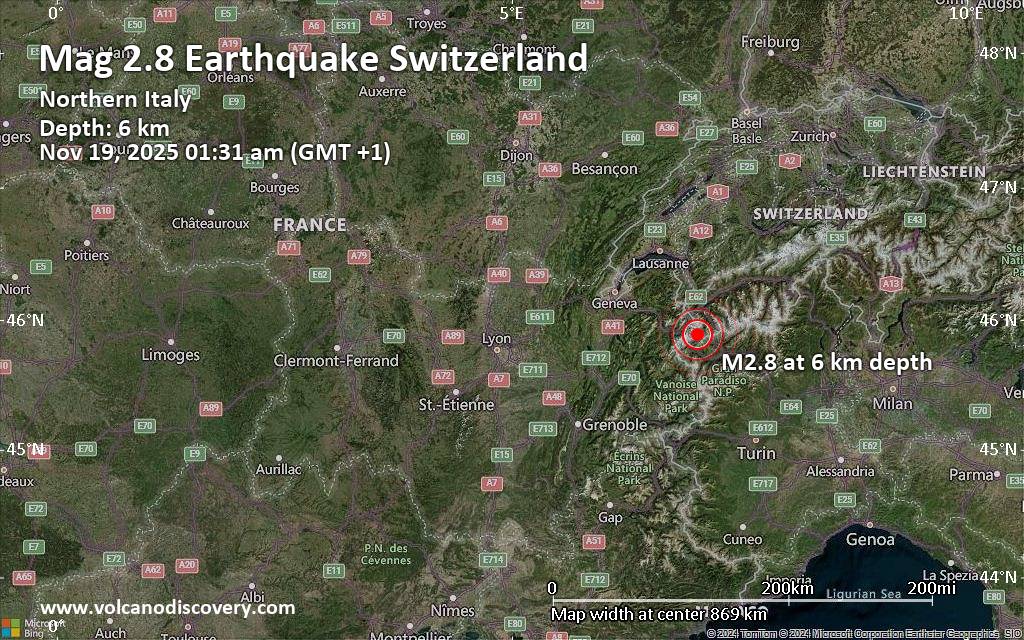 A very shallow magnitude 2.8 earthquake was reported early morning near Sitten, Sion District, Canton du Valais, Switzerland.
According to the European-Mediterranean Seismological Centre (EMSC), the quake hit on Wednesday, November 19th, 2025, at 1:31 am local time at a very shallow depth of 6.10 km. Shallow earthquakes are felt more strongly than deeper ones as they are closer to the surface. The exact magnitude, epicenter, and depth of the quake might be revised within the next few hours or minutes as seismologists review data and refine their calculations, or as other agencies issue their report.
Our monitoring service identified a second report from France's Réseau National de Surveillance Sismique (RéNaSS) which listed the quake at magnitude 2.9.
Towns or cities near the epicenter where the quake might have been felt as very weak shaking include Chamonix (pop. 10,600) located 13 km from the epicenter, and Bourg-Saint-Pierre (pop. 210) 15 km away. In Martigny-Ville (pop. 14,800, 24 km away), Bagnes (pop. 6,600, 26 km away), Aosta (pop. 35,300, 28 km away), Sallanches (pop. 16,700, 32 km away), Cluses (pop. 19,800, 40 km away), Monthey (pop. 15,100, 41 km away), and Sitten (pop. 28,000, 45 km away), the quake was probably not felt.
Earthquake data: Date & time: Nov 19, 2025 01:31 am (GMT +1) local time (19 Nov 2025 00:31 GMT)Magnitude: 2.8 Depth: 6.10 km Epicenter latitude / longitude: 45.89°N / 7.03°E  ( Valle d'Aosta, Aosta Valley, Italy) Primary data source: EMSChttps://www.volcanodiscovery.com/earthquake/news/287239/Small-magnitude-28-quake-hits-45-km-southwest-of-Sitten-Switzerland-early-morning-.html
0
8
Read More
|
World Earthquake Report for Tuesday, 18 November 2025
Webmaster
5 hours ago
World Earthquake Report for Tuesday, 18 November 2025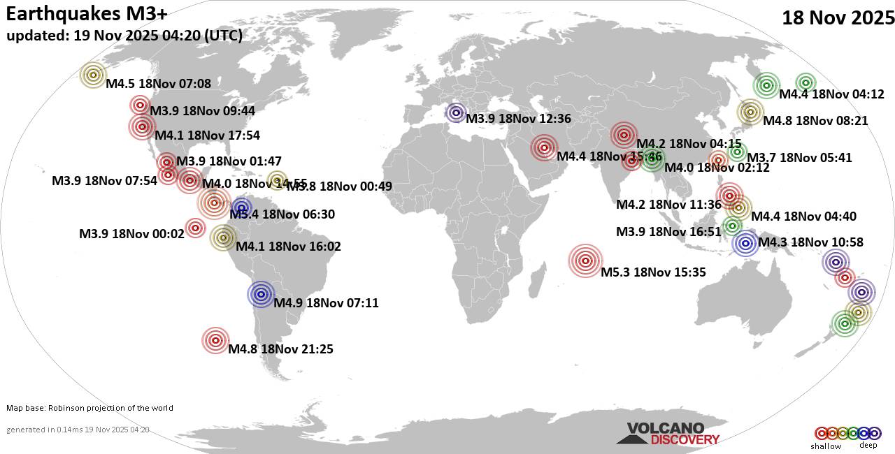 Worldwide earthquakes above magnitude 3 during the past 24 hours on 19 Nov 2025 Magnitude 5+: 3 earthquakes Magnitude 4+: 28 earthquakes Magnitude 3+: 161 earthquakes Magnitude 2+: 336 earthquakes No quakes of magnitude 6 or higher 10 largest earthquakes in the world (18 Nov 2025)Tuesday, Nov 18, 2025, at 12:30 am (GMT -6) - Tuesday, Nov 18, 2025, at 04:36 pm (Costa Rica time) - Tuesday, Nov 18, 2025, at 07:35 pm (GMT +4) - Tuesday, Nov 18, 2025, at 04:11 am (Salta time) - Tuesday, Nov 18, 2025, at 01:55 pm (GMT +13) - Tuesday, Nov 18, 2025, at 03:25 pm (GMT -6) - Tuesday, Nov 18, 2025, at 06:21 pm (GMT +10) - Wednesday, Nov 19, 2025, at 03:42 am (GMT +13) - Tuesday, Nov 18, 2025, at 11:19 am (GMT +11) - Monday, Nov 17, 2025, at 08:08 pm (GMT -11) - Earthquakes reported feltTuesday, Nov 18, 2025, at 09:54 am (GMT -8) - Monday, Nov 17, 2025, at 10:47 pm (GMT -8) - Tuesday, Nov 18, 2025, at 04:36 pm (Costa Rica time) - Tuesday, Nov 18, 2025, at 11:44 pm (Istanbul time) - Tuesday, Nov 18, 2025, at 05:32 am (GMT +2) - Tuesday, Nov 18, 2025, at 12:30 am (GMT -6) - Tuesday, Nov 18, 2025, at 04:45 pm (GMT -6) - Tuesday, Nov 18, 2025, at 02:00 am (GMT +2) - Tuesday, Nov 18, 2025, at 04:48 pm (GMT -6) - Tuesday, Nov 18, 2025, at 04:11 am (Salta time) - Tuesday, Nov 18, 2025, at 07:36 pm (GMT +8) - Tuesday, Nov 18, 2025, at 05:45 am (GMT +1) - Tuesday, Nov 18, 2025, at 05:43 pm (GMT -6) - Tuesday, Nov 18, 2025, at 11:44 pm (Istanbul time) - Tuesday, Nov 18, 2025, at 02:22 am (GMT +2) - Tuesday, Nov 18, 2025, at 05:54 pm (GMT +5:30) - Earthquake stats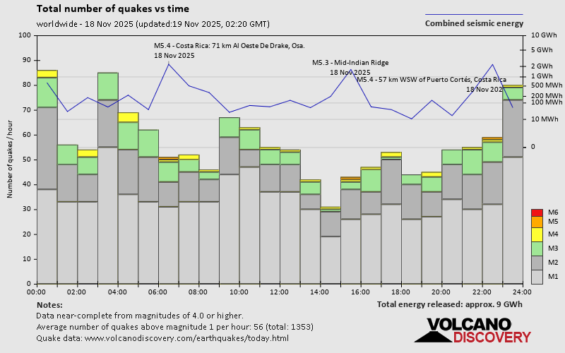 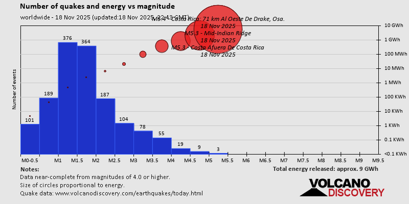  https://www.volcanodiscovery.com/earthquake/news/287162/World-Earthquake-Report-for-Tuesday-18-November-2025.html https://www.volcanodiscovery.com/earthquake/news/287162/World-Earthquake-Report-for-Tuesday-18-November-2025.html
0
9
Read More
|
Volcano earthquake report for Tuesday, 18 Nov 2025
Webmaster
Yesterday at 11:50 PM
Volcano earthquake report for Tuesday, 18 Nov 2025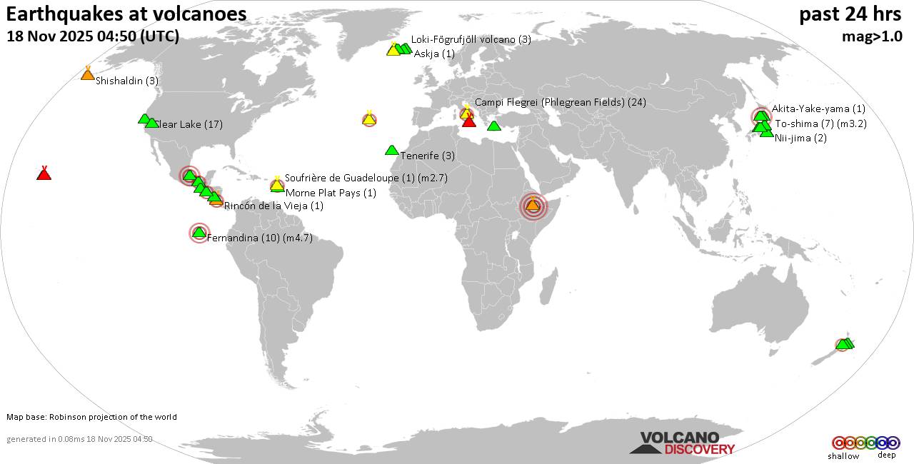 World map showing volcanoes with shallow (less than 50 km) earthquakes within 20 km radius during the past 24 hours on 18 Nov 2025 Number in brackets indicate nr of quakes. Quakes detected near: Akagi (3 quakes between mag 0.5-1.6), Akuseki-jima (1 quake mag 1.8), Barva (1 quake mag 1.7), Campi Flegrei (Phlegrean Fields) (19 quakes between mag 0.1-1.8), Clear Lake (16 quakes between mag 0.6-1.2), Cleveland (1 quake mag 2.1)
Coso (3 quakes between mag 0.8-1.1), Daisen (3 quakes between mag 0.3-1.2), El Chichón (4 quakes between mag 1.9-2.7), El Hierro (1 quake mag 1.9), Eldey (47 quakes between mag 0.2-2.0), Erciyes Dagi (2 quakes between mag 1.2-1.6), Etna (2 quakes between mag 1.3-1.6), Fagradalsfjall (2 quakes between mag 0.7-1.1), Fernandina (2 quakes between mag 3.1-3.9), Hakone (1 quake mag 2.1), Hiuchi (7 quakes between mag 0.2-1.0), Hrómundartindur (8 quakes between mag 0.4-1.1), Kilauea (4 quakes between mag 1.7-1.8), Kolumbo (4 quakes between mag 1.5-2.0), Krísuvík (9 quakes between mag 0.1-1.1), Ljósufjöll (5 quakes between mag 0.2-2.6), Loihi (1 quake mag 1.7), Loki-Fögrufjöll volcano (3 quakes between mag 0.6-1.7), Mammoth Mountain (1 quake mag 1.2), Mauna Kea (1 quake mag 1.9), Maunaloa (1 quake mag 2.1), Mount St. Helens (5 quakes between mag 0.2-1.2), Nejapa-Miraflores (1 quake mag 3.0), Nii-jima (1 quake mag 1.7), Niigata-Yake-yama (1 quake mag 3.0), Prestahnukur (1 quake mag 1.4), Santorini (1 quake mag 1.3), Shishaldin (2 quakes between mag 0.9-1.3), Taupo (1 quake mag 2.2), Tenerife (1 quake mag 1.2), Terceira (3 quakes between mag 2.0-2.3), Tjörnes Fracture Zone (1 quake mag 1.1), Towada (1 quake mag 1.7), Veniaminof (2 quakes between mag 0.2-1.3), Washiba-Kumonotaira (5 quakes between mag 0.2-2.1) (updated 23h50)
Note: Earthquakes within 20 km from and at depths less than 50 km under active volcanoes are reported. The list is not complete because many volcanoes are not monitored and/or seismic data in high resolution is not available publicly.
Volcanoes with recent earthquakes above magnitude 2 or more than 10 quakes are listed below:
Campi Flegrei (Phlegrean Fields) volcano (Italy): 19 earthquakes up to magnitude 1.8Possible earthquake swarm: 19 earthquakes occurred near (under) the volcano during 16 hours, the last being recorded quake 8 hours ago. Hypocenter depths ranged between 3.43 and 0.21 km. Earthquake details: (only 5 largest) 1.8 quake 3.4 km west of Fuorigrotta, Napoli, Campania, Italy, Nov 18, 2025 06:05 am (GMT +1) (2 km E) 1.1 quake 4.1 km southeast of Pozzuoli, Napoli, Campania, Italy, Nov 18, 2025 07:00 am (GMT +1) (0 km SW) 1.1 quake 4.3 km west of Fuorigrotta, Napoli, Campania, Italy, Nov 18, 2025 02:35 am (GMT +1) (1 km ESE) 1.1 quake 12 km west of Naples, Napoli, Campania, Italy, Nov 18, 2025 11:53 am (GMT +1) (1 km NW) 1.0 quake 0.9 km west of Bagnoli, Napoli, Campania, Italy, Nov 18, 2025 12:53 am (GMT +1) (3 km SE) All earthquakes at Campi Flegrei (Phlegrean Fields)Clear Lake volcano (California): 16 earthquakes up to magnitude 1.2Possible earthquake swarm: 16 earthquakes occurred near (under) the volcano during 21 hours, the last being recorded quake 1 hour 21 minutes ago. Hypocenter depths ranged between 3.85 and 0.70 km. Earthquake details: (only 5 largest) 1.2 quake Lake County, 28 mi north of Santa Rosa, Sonoma County, California, United States, Nov 17, 2025 07:37 pm (GMT -8) (15 km S) 1.0 quake 25 mi north of Santa Rosa, Sonoma County, California, United States, Nov 18, 2025 07:42 am (GMT -8) (19 km S) 1.0 quake 26 mi north of Santa Rosa, Sonoma County, California, United States, Nov 18, 2025 05:15 am (GMT -8) (18 km SSW) 1.0 quake 26 mi north of Santa Rosa, Sonoma County, California, United States, Nov 18, 2025 03:28 am (GMT -8) (17 km S) 1.0 quake 28 mi north of Santa Rosa, Sonoma County, California, United States, Nov 17, 2025 06:30 pm (GMT -8) (16 km SSW) All earthquakes at Clear LakeCleveland volcano (Aleutian Islands): magnitude 2.1 earthquakeA magnitude 2.1 earthquake occurred at the volcano 23 hours ago. The quake, which might be volcanic in origin, was located at a depth of 3.02 km depth at 5 km distance ESE from the volcano. Earthquake details: 2.1 quake Bering Sea, 3.9 mi southwest of Chuginadak Island, Aleutians West Census Area, Alaska, United States, Nov 17, 2025 02:52 pm (GMT -10) (5 km ESE) All earthquakes at ClevelandEl Chichón volcano (Southern Mexico): 4 earthquakes up to magnitude 2.74 earthquakes occurred near (under) the volcano during 10 hours, the last being recorded quake 13 hours ago. Hypocenter depths ranged between 5.40 and 2.80 km. Earthquake details: 2.7 quake Estado de Chiapas, 37 km southwest of Teapa, Estado de Tabasco, Mexico, Nov 17, 2025 07:02 pm (GMT -6) (1 km W) 2.5 quake Estado de Chiapas, 36 km southwest of Teapa, Estado de Tabasco, Mexico, Nov 17, 2025 07:47 pm (GMT -6) (0 km WNW) 2.1 quake Estado de Chiapas, 36 km southwest of Teapa, Estado de Tabasco, Mexico, Nov 18, 2025 03:09 am (GMT -6) (1 km SSE) 1.9 quake Estado de Chiapas, 37 km southwest of Teapa, Estado de Tabasco, Mexico, Nov 18, 2025 04:39 am (GMT -6) (1 km SSW) All earthquakes at El ChichónEldey volcano (Iceland): 47 earthquakes up to magnitude 2.0Possible earthquake swarm: 47 earthquakes occurred near (under) the volcano during 19 hours, the last being recorded quake 17 minutes ago. Hypocenter depths ranged between 12.40 and 1.10 km. Earthquake details: (only 5 largest) 2.0 quake Iceland: 7.2 km W of Reykjanestá Nov 18, 2025 11:14 pm (Reykjavik time) (10 km NE) 1.7 quake Iceland: 7.2 km NE of Eldey Nov 18, 2025 10:29 pm (Reykjavik time) (9 km NE) 1.6 quake Iceland: 7.3 km NE of Eldey Nov 18, 2025 11:25 pm (Reykjavik time) (9 km NE) 1.6 quake Iceland: 7.0 km WSW of Reykjanestá Nov 18, 2025 11:29 pm (Reykjavik time) (10 km NE) 1.6 quake Iceland: 7.2 km W of Reykjanestá Nov 18, 2025 10:05 pm (Reykjavik time) (10 km NE) All earthquakes at EldeyEldey is located at the beginning of the Reykjanes Ridge off the SW tip of Iceland. Its highest elevation is the top of Eldey Island, but most of the volcanic edifice is submerged. Several eruptions occurred in historic times, last in 1926. Fernandina volcano (Galapagos Islands): 2 earthquakes up to magnitude 3.92 earthquakes occurred near (under) the volcano during 14 hours, the last being recorded quake 10 hours ago. Hypocenter depths ranged between 1.00 and 0.00 km. Earthquake details: 3.9 quake 94 km northwest of Puerto Villamil, Provincia de Galapagos, Ecuador, Nov 17, 2025 07:02 pm (GMT -5) (3 km N) 3.1 quake 93 km northwest of Puerto Villamil, Provincia de Galapagos, Ecuador, Nov 18, 2025 07:52 am (GMT -6) (4 km NNE) All earthquakes at FernandinaHakone volcano (Honshu): magnitude 2.1 earthquakeA magnitude 2.1 earthquake occurred at the volcano 13 hours ago. The quake, which might be volcanic in origin, was located at a depth of 8.80 km depth at 17 km distance NNE from the volcano. Earthquake details: 2.1 quake 13 km west of Hadano, Kanagawa, Japan, Nov 18, 2025 08:18 pm (GMT +9) (17 km NNE) All earthquakes at HakoneLjósufjöll volcano (Iceland): 5 earthquakes up to magnitude 2.65 earthquakes occurred near (under) the volcano during 19 hours, the last being recorded quake 3 hours ago. Hypocenter depths ranged between 18.10 and 13.10 km. Earthquake details: 2.6 quake 27.5 km N of Borgarnes Nov 18, 2025 04:31 am (Universal Time) (16 km ESE) 1.1 quake Iceland: 27.9 km N of Borgarnes Nov 18, 2025 08:59 pm (Reykjavik time) (18 km ESE) 0.8 quake Iceland: 27.7 km N of Borgarnes Nov 18, 2025 03:38 am (Reykjavik time) (15 km ESE) 0.4 quake Iceland: 28.2 km N of Borgarnes Nov 18, 2025 03:40 am (Reykjavik time) (15 km ESE) 0.2 quake Iceland: 28.4 km N of Borgarnes Nov 18, 2025 01:40 am (Reykjavik time) (14 km ESE) All earthquakes at LjósufjöllMaunaloa volcano (Hawai'i (Big Island)): magnitude 2.1 earthquakeA magnitude 2.1 earthquake occurred at the volcano 37 minutes ago. The quake, which might be volcanic in origin, was located at a depth of 5.94 km depth at 17 km distance SE from the volcano. Earthquake details: 2.1 quake 11 mi north of Pāhala, Hawaii County, Hawaii, United States, Nov 18, 2025 01:13 pm (GMT -10) (17 km SE) All earthquakes at MaunaloaNejapa-Miraflores volcano (Nicaragua): magnitude 3.0 earthquakeA magnitude 3.0 earthquake occurred at the volcano 24 hours ago. The quake, which might be volcanic in origin, was located at a depth of 10.00 km depth at 6 km distance NNW from the volcano. Earthquake details: Reported seismic-like event (likely no quake): 10.8 km west of Managua, Departamento de Managua, Nicaragua, Nov 17, 2025 05:55 pm (GMT -6) (6 km NNW) All earthquakes at Nejapa-MirafloresNiigata-Yake-yama volcano (Honshu): magnitude 3.0 earthquakeA magnitude 3.0 earthquake occurred at the volcano 8 hours ago. The quake, which might be volcanic in origin, was located at a depth of 10.00 km depth at 12 km distance NNW from the volcano. Earthquake details: Reported seismic-like event (likely no quake): 25 km southwest of Joetsu, Niigata, Japan, Nov 19, 2025 12:59 am (GMT +9) (12 km NNW) All earthquakes at Niigata-Yake-yamaTaupo volcano (New Zealand): magnitude 2.2 earthquakeA magnitude 2.2 earthquake occurred at the volcano 3 hours ago. The quake, which might be volcanic in origin, was located at a depth of 6.30 km depth at 19 km distance NNE from the volcano. Earthquake details: 2.2 quake 2.1 km north of Taupo, Waikato, New Zealand, Nov 19, 2025 09:41 am (GMT +13) (19 km NNE) All earthquakes at TaupoTerceira volcano (Azores): 3 earthquakes up to magnitude 2.33 earthquakes occurred near (under) the volcano during 6 hours, the last being recorded quake 18 hours ago. Hypocenter depths ranged between 3.30 and 0.60 km. Earthquake details: 2.3 quake 15 km northwest of Angra do Heroismo, Azores, Portugal, Nov 17, 2025 10:55 pm (GMT -1) (3 km NNW) 2.2 quake 12 km northwest of Angra do Heroismo, Azores, Portugal, Nov 18, 2025 04:27 am (GMT -1) (3 km ENE) 2.0 quake 12 km northwest of Angra do Heroismo, Azores, Portugal, Nov 17, 2025 11:28 pm (GMT -1) (2 km ENE) All earthquakes at TerceiraUnnamed 52.92°N/158.52°E volcano (Southern Kamchatka): magnitude 3.0 earthquakeA magnitude 3.0 earthquake occurred at the volcano 9 hours ago. The quake, which might be volcanic in origin, was located at a depth of 10.00 km depth at 17 km distance NNE from the volcano. Earthquake details: Reported seismic-like event (likely no quake): 1.9 km southeast of Petropavlovsk-Kamchatskiy, Kamchatka, Russia, Nov 19, 2025 02:30 am (GMT +12) (17 km NNE) All earthquakes at Unnamed 52.92°N/158.52°EWashiba-Kumonotaira volcano (Honshu): 5 earthquakes up to magnitude 2.15 earthquakes occurred near (under) the volcano during 1 hour 38 minutes, the last being recorded quake 19 hours ago. Hypocenter depths ranged between 4.70 and 2.30 km. Earthquake details: 2.1 quake Gifu, 34 km northwest of Matsumoto, Nagano, Japan, Nov 18, 2025 12:56 pm (GMT +9) (7 km SSE) 0.7 quake 33 km northwest of Matsumoto, Nagano, Japan, Nov 18, 2025 01:04 pm (GMT +9) (6 km SSE) 0.6 quake 34 km northwest of Matsumoto, Nagano, Japan, Nov 18, 2025 02:15 pm (GMT +9) (6 km SSE) 0.3 quake 34 km northwest of Matsumoto, Nagano, Japan, Nov 18, 2025 12:37 pm (GMT +9) (6 km SSE) 0.2 quake 34 km northwest of Matsumoto, Nagano, Japan, Nov 18, 2025 01:14 pm (GMT +9) (6 km SSE) All earthquakes at Washiba-Kumonotairahttps://www.volcanodiscovery.com/earthquakes-volcanoes/news/287152/Volcano-earthquake-report-for-Tuesday-18-Nov-2025.html
0
Read More
|
Magnitude 5.5 earthquake strikes near San Isidro, Pérez Zeledón, Provincia de San Jose, Costa Rica
Webmaster
Yesterday at 10:46 PM
Magnitude 5.5 earthquake strikes near San Isidro, Pérez Zeledón, Provincia de San Jose, Costa Rica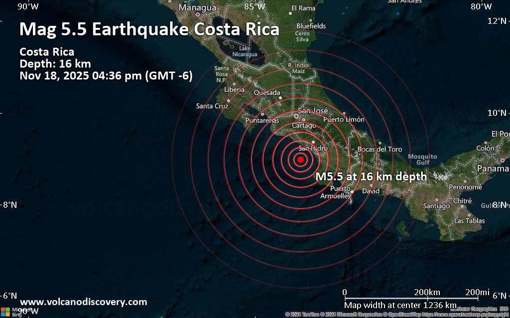 An earthquake of magnitude 5.5 occurred in the afternoon on Tuesday, November 18th, 2025, at 4:36 pm local time near San Isidro, Pérez Zeledón, Provincia de San Jose, Costa Rica, as reported by the European-Mediterranean Seismological Centre (EMSC).
According to preliminary data, the quake was located at a shallow depth of 16. km. Shallow earthquakes are felt more strongly than deeper ones as they are closer to the surface. The exact magnitude, epicenter, and depth of the quake might be revised within the next few hours or minutes as seismologists review data and refine their calculations, or as other agencies issue their report.
A second report was later issued by the citizen-seismograph network of RaspberryShake, which listed it as a magnitude 5.3 earthquake. Other agencies reporting the same quake include the German Research Centre for Geosciences (GFZ) at magnitude 5.3, and The Colombian Geological Service (SGC) at magnitude 5.3.
Based on the preliminary seismic data, the quake was probably felt by many people in the area of the epicenter. It should not have caused significant damage, other than objects falling from shelves, broken windows, etc.
In Puerto Cortes (pop. 3,900) located 52 km from the epicenter, and San Isidro (pop. 34,900) 54 km away, the quake should have been felt as light shaking.
Weak shaking might have been felt in Tejar (pop. 22,400) located 88 km from the epicenter, Paraiso (pop. 39,700) 96 km away, Aserri (pop. 25,900) 98 km away, Cartago (pop. 26,600) 98 km away, San Miguel (pop. 28,800) 99 km away, San Rafael Abajo (pop. 27,400) 100 km away, and San Jose (pop. 335,000) 106 km away.
VolcanoDiscovery will automatically update magnitude and depth if these change and follow up if other significant news about the quake become available. If you’re in the area, please send us your experience through our reporting mechanism, either online or via our mobile app. This will help us provide more first-hand updates to anyone around the globe who wants to know more about this quake.
Earthquake data: Date & time: Nov 18, 2025 10:36 pm (Universal Time) local time (18 Nov 2025 22:36 GMT)Magnitude: 5.5 Depth: 16.00 km Epicenter latitude / longitude: 8.98°N / 84°W  ( Provincia de Puntarenas, Costa Rica) Primary data source: EMSChttps://www.volcanodiscovery.com/earthquake/news/287237/Magnitude-55-earthquake-strikes-near-San-Isidro-Perez-Zeledon-Provincia-de-San-Jose-Costa-Rica.html
0
Read More
|
Seismic-like event, possible earthquake, reported few minutes ago near Buenos Aires, Puntarenas Province, Costa Rica
Webmaster
Yesterday at 10:39 PM
Seismic-like event, possible earthquake, reported few minutes ago near Buenos Aires, Puntarenas Province, Costa Rica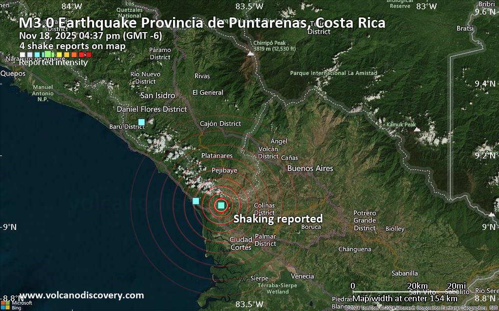 Unconfirmed quake or seismic-like event reported: 30 km southwest of Buenos Aires, Provincia de Puntarenas, Costa Rica, 1 minute ago We are receiving unverified early reports of ground shaking possibly caused by seismic activity in or near Buenos Aires, Puntarenas Province, Costa Rica on 18 Nov 2025 (GMT) at approximately 22:37 GMT.
There are no details yet on the magnitude or depth of this possible quake. If confirmed, we can expect more accurate data to emerge in the next few minutes. The location, magnitude and time mentioned are indicative, based on our best-fit seismic model. They are temporary until our AllQuakes monitoring service receives more exact scientific data from a national or international seismological agency. Check back here shortly and stay safe.
Earthquake data: Date & time: Nov 18, 2025 04:37 pm (GMT -6) local time (18 Nov 2025 22:37 GMT)Magnitude: unspecified Depth: unspecified Epicenter latitude / longitude: 9.06°N / 83.58°W ( Provincia de Puntarenas, Costa Rica) Primary data source: VolcanoDiscoveryhttps://www.volcanodiscovery.com/earthquake/news/287233/Seismic-like-event-possible-earthquake-reported-few-minutes-ago-near-Buenos-Aires-Puntarenas-Provinc.html
0
Read More
|
Magnitude 4.1 earthquake strikes near Homer, Kenai Peninsula, Alaska, USA
Webmaster
Yesterday at 10:01 PM
Magnitude 4.1 earthquake strikes near Homer, Kenai Peninsula, Alaska, USA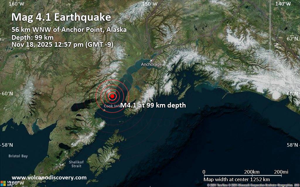 An earthquake of magnitude 4.1 occurred around noon on Tuesday, November 18th, 2025, at 12:57 pm local time near Homer, Kenai Peninsula, Alaska, USA, as reported by the United States Geological Survey.
According to preliminary data, the quake was located at an intermediate depth of 62 miles. The exact magnitude, epicenter, and depth of the quake might be revised within the next few hours or minutes as seismologists review data and refine their calculations, or as other agencies issue their report.
A second report was later issued by The Incorporated Research Institutions for Seismology (IRIS), which listed it as a magnitude 4.2 earthquake.
Towns or cities near the epicenter where the quake might have been felt as very weak shaking include Anchor Point (pop. 1,900) located 35 miles from the epicenter. In Diamond Ridge (pop. 1,200, 46 miles away), Homer (pop. 5,500, 47 miles away), Fritz Creek (pop. 1,900, 54 miles away), and Cohoe (pop. 1,400, 62 miles away), the quake was probably not felt.
Earthquake data: Date & time: Nov 18, 2025 12:57 pm (GMT -9) local time (18 Nov 2025 21:57 GMT)Magnitude: 4.1 Depth: 99.39 km Epicenter latitude / longitude: 59.89°N / 152.82°W  ( Kenai Peninsula Borough, Alaska, United States) Primary data source: USGShttps://www.volcanodiscovery.com/earthquake/news/287231/Magnitude-41-earthquake-strikes-near-Homer-Kenai-Peninsula-Alaska-USA.html
0
Read More
|
Magnitude 3.5 earthquake strikes near Izmir, Turkey
Webmaster
Yesterday at 08:58 PM
Magnitude 3.5 earthquake strikes near Izmir, Turkey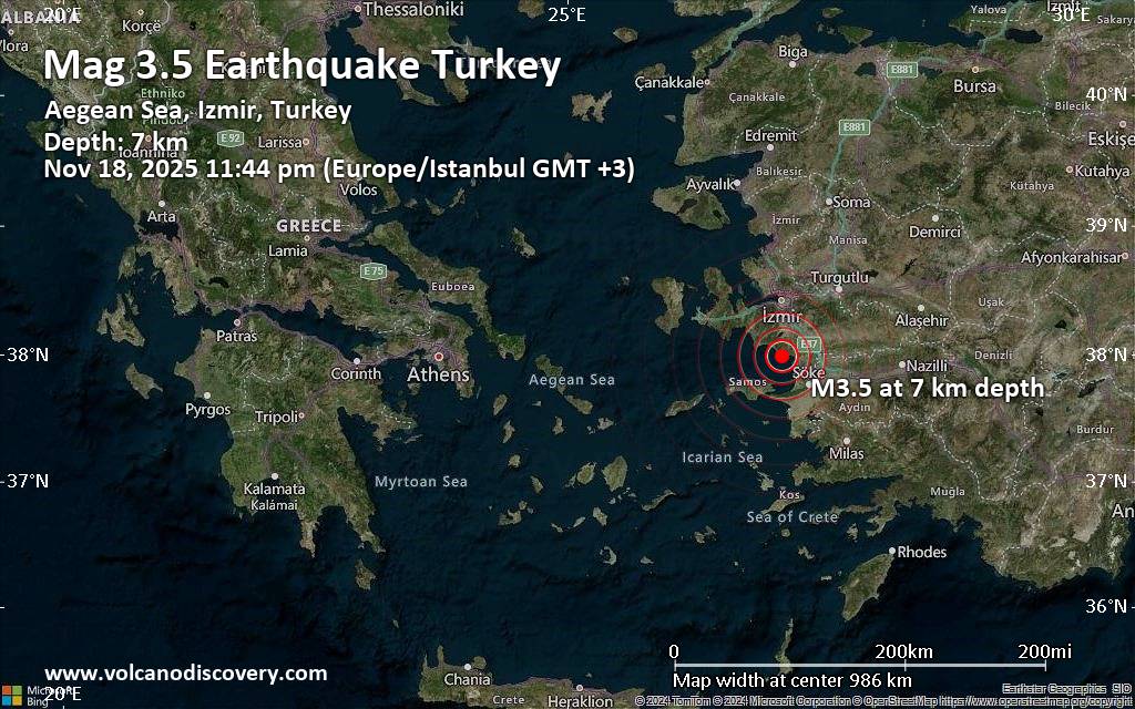 Turkey's Disaster and Emergency Management Authority (AFAD) reported a magnitude 3.5 quake in Turkey near Izmir, only 13 minutes ago. The earthquake hit late at night on Tuesday, November 18th, 2025, at 11:44 pm local time at a very shallow depth of 7. km. The exact magnitude, epicenter, and depth of the quake might be revised within the next few hours or minutes as seismologists review data and refine their calculations, or as other agencies issue their report.
A second report was later issued by the European-Mediterranean Seismological Centre (EMSC), which listed it as a magnitude 3.1 earthquake. Other agencies reporting the same quake include the Kandilli Oservatory and Earthquake Research Institute in Istanbul (KOERI-RETMC) at magnitude 3.6, the National Observatory of Athens (NOA) at magnitude 3.7, the citizen-seismograph network of RaspberryShake at magnitude 3.5, and The Aristotle University of Thessaloniki Geophysical Lab. (AUTH) at magnitude 3.4.
Based on the preliminary seismic data, the quake should not have caused any significant damage, but was probably felt by many people as light vibration in the area of the epicenter.
Weak shaking might have been felt in Ozdere (pop. 13,500) located 3 km from the epicenter.
Other towns or cities near the epicenter where the quake might have been felt as very weak shaking include Kusadasi (pop. 63,200) located 18 km from the epicenter, Selcuk (pop. 29,100) 21 km away, Torbali (pop. 50,300) 27 km away, Menderes (pop. 22,000) 29 km away, Soeke (pop. 68,200) 36 km away, Karabaglar (pop. 458,000) 43 km away, Izmir (pop. 2,500,600) 47 km away, and Urla (pop. 45,200) 49 km away.
Earthquake data: Date & time: Nov 18, 2025 11:44 pm (Istanbul time) local time (18 Nov 2025 20:44 GMT)Magnitude: 3.5 Depth: 7.00 km Epicenter latitude / longitude: 37.99°N / 27.13°E  (Menderes District, Izmir, Turkey) Primary data source: AFADhttps://www.volcanodiscovery.com/earthquake/news/287228/Magnitude-35-earthquake-strikes-near-Izmir-Turkey.html
0
Read More
|
|
Forums60
Topics748,614
Posts783,277
Members2,958
| |
Most Online4,474
Nov 17th, 2025
|
|
|
|
|
Copyright 1996 - 2024 by David Cottle. Designed by David Bate Jr. All Rights Reserved.
By using this forum, the user agrees not to transfer any data or technical information received under the agreement, to any other entity without the express approval of the AUS-CITY Forum Admins and/or authors of individual posts (Forum Admins and DoD/USSPACECOM for the analysis of satellite tracking data).
Two-line elements (TLE) and all other satellite data presented and distributed via this forum and e-mail lists of AUS-CITY are distributed with permission from DoD/USSTRATCOM.


Reprise Hosting

|

|


 - Click image for larger picture.")


