|
|
|
0 members (),
5,908
guests, and
21
robots. |
|
Key:
Admin,
Global Mod,
Mod
|
|
S |
M |
T |
W |
T |
F |
S |
|
|
|
|
|
|
1
|
2
|
|
3
|
4
|
5
|
6
|
7
|
8
|
9
|
|
10
|
11
|
12
|
13
|
14
|
15
|
16
|
|
17
|
18
|
19
|
20
|
21
|
22
|
23
|
|
24
|
25
|
26
|
27
|
28
|
29
|
30
|
|
31
|
|
|
|
|
|
|
|
There are no members with birthdays on this day. |
 World Earthquake Report for Saturday, 2 May 2026
Webmaster
Yesterday at 11:20 AM
World Earthquake Report for Saturday, 2 May 2026
Webmaster
Yesterday at 11:20 AM
World Earthquake Report for Saturday, 2 May 2026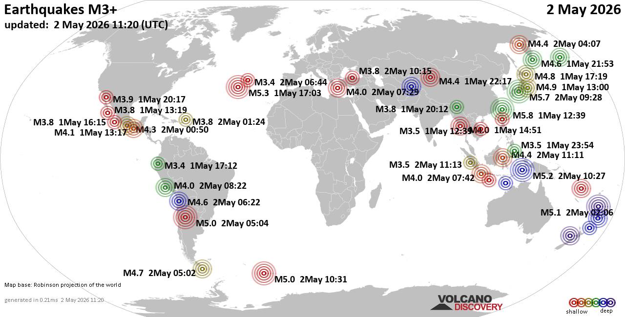 Worldwide earthquakes above magnitude 3 during the past 24 hours on 2 May 2026 Magnitude 5+: 7 earthquakes Magnitude 4+: 35 earthquakes Magnitude 3+: 147 earthquakes Magnitude 2+: 355 earthquakes No quakes of magnitude 6 or higher 10 largest earthquakes in the world (past 24 hours)Friday, May 1, 2026, at 08:39 pm (Taipei time) - Saturday, May 2, 2026, at 06:28 pm (GMT +9) - Friday, May 1, 2026, at 03:03 pm (GMT -2) - Saturday, May 2, 2026, at 07:27 pm (GMT +9) - Saturday, May 2, 2026, at 02:06 pm (GMT +12) - Saturday, May 2, 2026, at 02:04 am (La Rioja time) - Saturday, May 2, 2026, at 08:31 am (GMT -2) - Friday, May 1, 2026, at 10:00 pm (GMT +9) - Saturday, May 2, 2026, at 02:19 am (GMT +9) - Friday, May 1, 2026, at 11:40 pm (GMT +9) - Earthquakes reported feltSaturday, May 2, 2026, at 06:28 pm (GMT +9) - Friday, May 1, 2026, at 08:39 pm (Taipei time) - Saturday, May 2, 2026, at 03:10 am (GMT -7) - Saturday, May 2, 2026, at 02:04 am (La Rioja time) - Saturday, May 2, 2026, at 05:36 pm (GMT +9) - Saturday, May 2, 2026, at 10:43 pm (GMT +12) - Friday, May 1, 2026, at 09:21 pm (Yangon time) - Friday, May 1, 2026, at 11:50 am (GMT -6) - Saturday, May 2, 2026, at 09:29 am (GMT +2) - Saturday, May 2, 2026, at 12:03 pm (Yangon time) - Saturday, May 2, 2026, at 01:33 am (GMT +3) - Friday, May 1, 2026, at 07:49 pm (GMT -7) - Friday, May 1, 2026, at 11:57 am (GMT -4) - Earthquake stats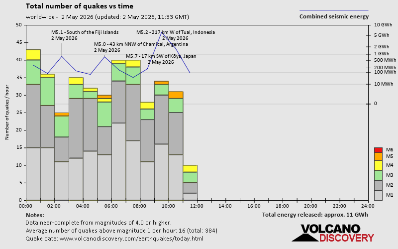 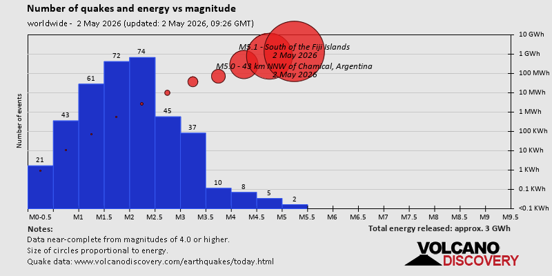 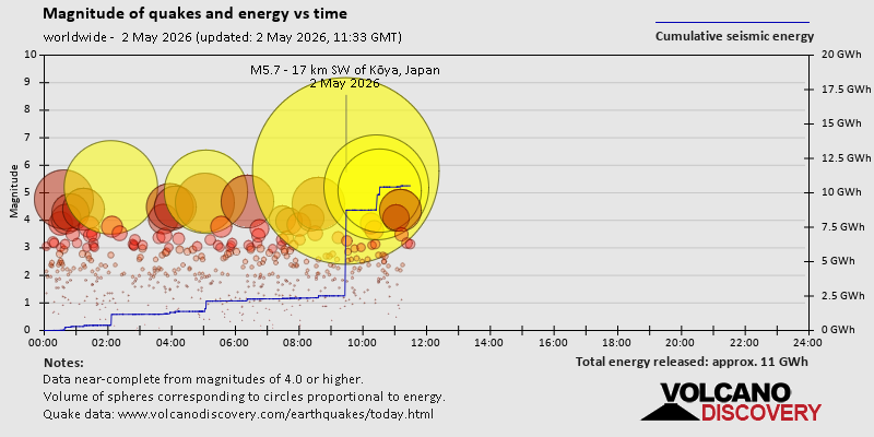 https://www.volcanodiscovery.com/earthquake/news/301244/World-Earthquake-Report-for-Saturday-2-May-2026.html https://www.volcanodiscovery.com/earthquake/news/301244/World-Earthquake-Report-for-Saturday-2-May-2026.html
0
16
Read More
|
Monday: Light Cloud, Minimum Temperature: 6°C (43°F) Maximum Temperature: 16°C (60°F)
Webmaster
Yesterday at 11:01 AM
Maximum Temperature: 16°C (60°F), Minimum Temperature: 6°C (43°F), Wind Direction: north-westerly, Wind Speed: 6mph, Visibility: Very Good, Pressure: 1014mb, Humidity: 65%, UV Risk: 4, Pollution: Low, Sunrise: 05:29 BST, Sunset: 20:43 BST Source: Monday: Light Cloud, Minimum Temperature: 6°C (43°F) Maximum Temperature: 16°C (60°F)
0
15
Read More
|
Sunday: Light Rain, Minimum Temperature: 8°C (46°F) Maximum Temperature: 15°C (58°F)
Webmaster
Yesterday at 11:01 AM
Maximum Temperature: 15°C (58°F), Minimum Temperature: 8°C (46°F), Wind Direction: north-easterly, Wind Speed: 7mph, Visibility: Moderate, Pressure: 1009mb, Humidity: 78%, UV Risk: 1, Pollution: Low, Sunrise: 05:31 BST, Sunset: 20:42 BST Source: Sunday: Light Rain, Minimum Temperature: 8°C (46°F) Maximum Temperature: 15°C (58°F)
0
12
Read More
|
Today: Light Cloud, Minimum Temperature: 11°C (52°F) Maximum Temperature: 19°C (66°F)
Webmaster
Yesterday at 11:01 AM
Maximum Temperature: 19°C (66°F), Minimum Temperature: 11°C (52°F), Wind Direction: south-westerly, Wind Speed: 2mph, Visibility: Very Good, Pressure: 1014mb, Humidity: 46%, UV Risk: 3, Pollution: Low, Sunrise: 05:33 BST, Sunset: 20:40 BST Source: Today: Light Cloud, Minimum Temperature: 11°C (52°F) Maximum Temperature: 19°C (66°F)
0
14
Read More
|
Volcano earthquake report for Saturday, 2 May 2026
Webmaster
Yesterday at 10:50 AM
Volcano earthquake report for Saturday, 2 May 2026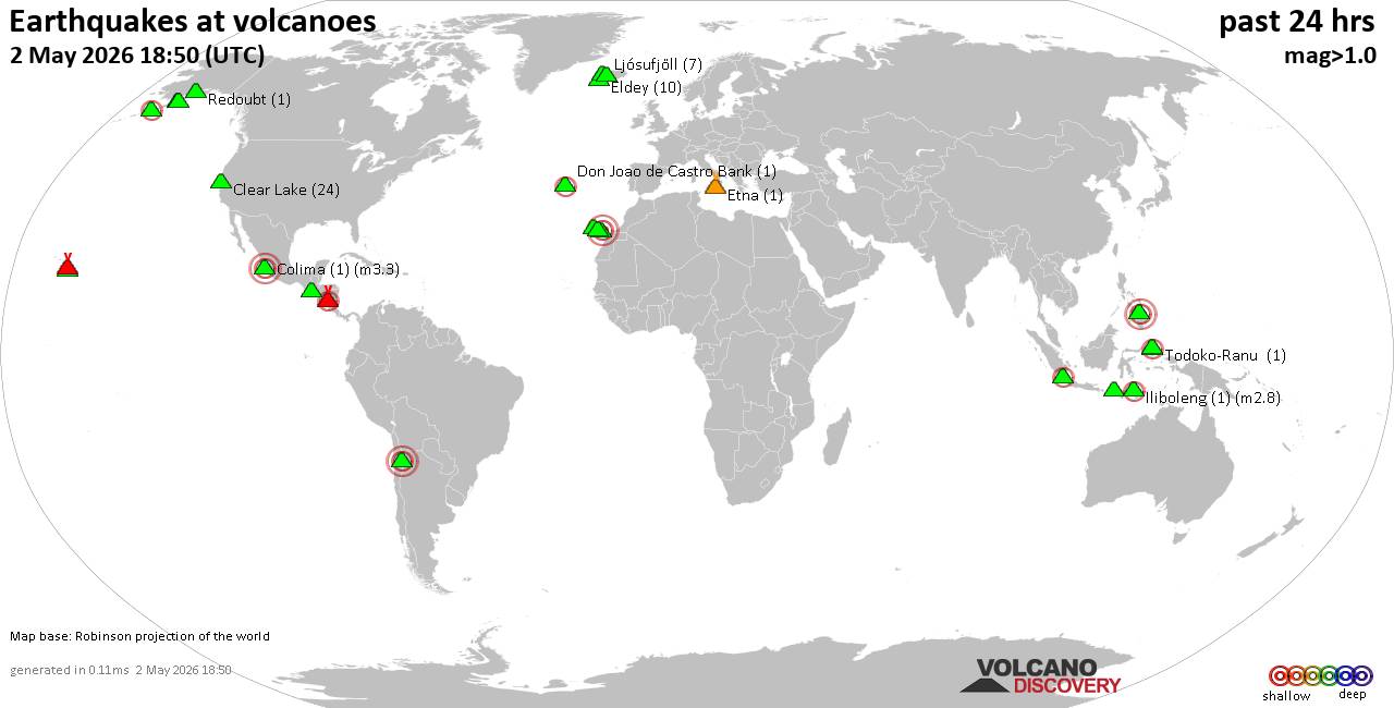 World map showing volcanoes with shallow (less than 50 km) earthquakes within 20 km radius during the past 24 hours on 2 May 2026 Number in brackets indicate nr of quakes. Quakes detected near: Clear Lake (25 quakes between mag 0.3-1.8), Don Joao de Castro Bank (1 quake mag 2.0), El Chichón (5 quakes between mag 2.2-2.6), Eldey (6 quakes between mag 0.4-1.4), Etna (1 quake mag 1.0), Gran Canaria (1 quake mag 3.0)
Hibok-Hibok (1 quake mag 3.0), Hulubelu (18 quakes between mag 2.0-2.9), Iliboleng (1 quake mag 2.8), Jailolo (1 quake mag 2.3), Katmai (2 quakes between mag 0.7-1.1), Kilauea (8 quakes between mag 1.6-2.2), La Palma (5 quakes between mag 1.0-1.6), Ljósufjöll (5 quakes between mag 0.5-1.4), Loihi (1 quake mag 2.6), Machin (1 quake mag 3.0), Martin (1 quake mag 1.1), Masaya (14 quakes between mag 0.0-2.3), Okmok (1 quake mag 1.3), Pacaya (2 quakes between mag 2.8-3.2), Papandayan (1 quake mag 2.1), Redoubt (1 quake mag 1.0), Ruapehu (1 quake mag 1.0), Santo Tomas (1 quake mag 2.3), Stepovak Bay 2 (1 quake mag 2.4), Taal (1 quake mag 1.5), Tambora (2 quakes between mag 2.1-2.2), Tenerife (2 quakes between mag 0.1-1.1), Timber Mountain (1 quake mag 1.7), Trident (1 quake mag 1.3), Una Una (1 quake mag 2.9), Wide Bay (1 quake mag 1.0) (updated 10h50)
Note: Earthquakes within 20 km from and at depths less than 50 km under active volcanoes are reported. The list is not complete because many volcanoes are not monitored and/or seismic data in high resolution is not available publicly.
Volcanoes with recent earthquakes above magnitude 2 or more than 10 quakes are listed below:
Clear Lake volcano (California): 25 earthquakes up to magnitude 1.8Possible earthquake swarm: 25 earthquakes occurred near (under) the volcano during 19 hours, the last being recorded quake 3 hours ago. Hypocenter depths ranged between 11.62 and 0.91 km. Earthquake details: (only 5 largest) 1.8 quake 12 mi southwest of Clearlake, Lake County, California, United States, May 2, 2026 12:20 am (GMT -7) (15 km S) 1.4 quake 27 mi north of Santa Rosa, Sonoma County, California, United States, May 1, 2026 10:41 am (GMT -7) (17 km S) 1.1 quake Lake County, 26 mi north of Santa Rosa, Sonoma County, California, United States, May 2, 2026 01:16 am (GMT -7) (17 km S) 1.1 quake 26 mi north of Santa Rosa, Sonoma County, California, United States, May 2, 2026 01:01 am (GMT -7) (18 km SSW) 1.1 quake 28 mi north of Santa Rosa, Sonoma County, California, United States, May 1, 2026 10:40 am (GMT -7) (16 km SSW) All earthquakes at Clear LakeEl Chichón volcano (Southern Mexico): 5 earthquakes up to magnitude 2.65 earthquakes occurred near (under) the volcano during 4 hours, the last being recorded quake 17 hours ago. Hypocenter depths ranged between 5.00 and 3.00 km. Earthquake details: 2.6 quake Estado de Chiapas, 35 km southwest of Teapa, Estado de Tabasco, Mexico, May 1, 2026 11:28 am (GMT -6) (3 km ESE) 2.4 quake Estado de Chiapas, 37 km southwest of Teapa, Estado de Tabasco, Mexico, May 1, 2026 07:55 am (GMT -6) (1 km SSW) 2.2 quake Estado de Chiapas, 37 km southwest of Teapa, Estado de Tabasco, Mexico, May 1, 2026 07:13 am (GMT -6) (2 km SE) 2.2 quake Estado de Chiapas, 35 km southwest of Teapa, Estado de Tabasco, Mexico, May 1, 2026 07:24 am (GMT -6) (2 km N) 2.2 quake Estado de Chiapas, 37 km southwest of Teapa, Estado de Tabasco, Mexico, May 1, 2026 09:09 am (GMT -6) (2 km NW) All earthquakes at El ChichónGran Canaria volcano (Canary Islands): magnitude 3.0 earthquakeA magnitude 3.0 earthquake occurred at the volcano 5 hours ago. The quake, which might be volcanic in origin, was located at a depth of 10.00 km depth at 19 km distance ENE from the volcano. Earthquake details: Uncertain quake: M3.0, 2.3 km southwest of Las Palmas de Gran Canaria, Spain, May 2, 2026 05:30 am (GMT +0) (19 km ENE) All earthquakes at Gran CanariaHibok-Hibok volcano (Mindanao): magnitude 3.0 earthquakeA magnitude 3.0 earthquake occurred at the volcano 5 hours ago. The quake, which might be volcanic in origin, was located at a depth of 10.00 km depth at 14 km distance ESE from the volcano. Earthquake details: Reported seismic-like event (likely no quake): 13 km southeast of Mambajao, Philippines, May 2, 2026 02:10 pm (GMT +8) (14 km ESE) All earthquakes at Hibok-HibokHulubelu volcano (Sumatra): 18 earthquakes up to magnitude 2.9Possible earthquake swarm: 18 earthquakes occurred near (under) the volcano during 5 hours, the last being recorded quake 9 hours ago. Hypocenter depths ranged between 22.00 and 1.00 km. Earthquake details: (only 5 largest) 2.9 quake Kabupaten Tanggamus, 75 km west of Bandar Lampung, Indonesia, May 2, 2026 07:37 am (GMT +7) (1 km SE) 2.8 quake Kabupaten Tanggamus, 84 km west of Bandar Lampung, Indonesia, May 2, 2026 07:30 am (GMT +7) (8 km WSW) 2.7 quake Kabupaten Tanggamus, 76 km west of Bandar Lampung, Indonesia, May 2, 2026 05:50 am (GMT +7) (1 km S) 2.5 quake Kabupaten Tanggamus, 69 km west of Bandar Lampung, Indonesia, May 2, 2026 04:36 am (GMT +7) (10 km SE) 2.5 quake Kabupaten Tanggamus, 76 km west of Bandar Lampung, Indonesia, May 2, 2026 07:15 am (GMT +7) (1 km S) All earthquakes at HulubeluIliboleng volcano (Lesser Sunda Islands): magnitude 2.8 earthquakeA magnitude 2.8 earthquake occurred at the volcano 10 hours ago. The quake, which might be volcanic in origin, was located at a depth of 3.00 km depth at 16 km distance SSW from the volcano. Earthquake details: 2.8 quake Savu Sea, 16 km south of Pulau Adonara Island, East Nusa Tenggara, Indonesia, May 2, 2026 09:12 am (GMT +8) (16 km SSW) All earthquakes at IlibolengJailolo volcano (Halmahera): magnitude 2.3 earthquakeA magnitude 2.3 earthquake occurred at the volcano 9 hours ago. The quake, which might be volcanic in origin, was located at a depth of 12.00 km depth at 5 km distance NNE from the volcano. Earthquake details: 2.3 quake Kabupaten Halmahera Barat, 37 km north of Ternate, Indonesia, May 2, 2026 11:14 am (GMT +9) (5 km NNE) All earthquakes at JailoloKilauea volcano (Hawai'i (Big Island)): 8 earthquakes up to magnitude 2.28 earthquakes occurred near (under) the volcano during 16 hours, the last being recorded quake 6 hours ago. Hypocenter depths ranged between 29.17 and 0.19 km. Earthquake details: (only 5 largest) 2.2 quake 7.2 mi northeast of Pāhala, Hawaii County, Hawaii, United States, May 1, 2026 06:34 pm (GMT -10) (19 km SW) 2.0 quake 26 mi southwest of Hilo, Hawaii County, Hawaii, United States, May 1, 2026 06:58 pm (GMT -10) (1 km SE) 1.9 quake 26 mi southwest of Hilo, Hawaii County, Hawaii, United States, May 1, 2026 02:56 am (GMT -10) (1 km SSE) 1.8 quake 4 mi southwest of Volcano, Hawaii County, Hawaii, United States, May 1, 2026 04:51 pm (GMT -10) (1 km ESE) 1.8 quake 4 mi southwest of Volcano, Hawaii County, Hawaii, United States, May 1, 2026 03:19 pm (GMT -10) (1 km ESE) All earthquakes at KilaueaLoihi volcano (Hawai'i (Big Island)): magnitude 2.6 earthquakeA magnitude 2.6 earthquake occurred at the volcano 6 hours ago. The quake, which might be volcanic in origin, was located at a depth of 33.09 km depth at 16 km distance NW from the volcano. Earthquake details: 2.6 quake North Pacific Ocean, 41 mi southeast of of Hawai‘i Island, Hawaii County, Hawaii, United States, May 1, 2026 06:46 pm (GMT -10) (16 km NW) All earthquakes at LoihiMachin volcano (Colombia): magnitude 3.0 earthquakeA magnitude 3.0 earthquake occurred at the volcano 22 hours ago. The quake, which might be volcanic in origin, was located at a depth of 10.00 km depth at 19 km distance ESE from the volcano. Earthquake details: Reported seismic-like event (likely no quake): 2.5 km west of Ibague, Departamento de Tolima, Colombia, May 1, 2026 07:34 am (GMT -5) (19 km ESE) All earthquakes at MachinMasaya volcano (Nicaragua): 14 earthquakes up to magnitude 2.3Possible earthquake swarm: 14 earthquakes occurred near (under) the volcano during 11 hours, the last being recorded quake 2 hours ago. Hypocenter depths ranged between 8.00 and 5.00 km. Earthquake details: (only 5 largest) 2.3 quake Departamento de Masaya, 13 km southeast of Managua, Nicaragua, May 2, 2026 12:32 am (GMT -6) (7 km NNW) 2.2 quake 3.9 km northwest of Masaya, Departamento de Masaya, Nicaragua, May 1, 2026 03:56 pm (GMT -6) (6 km ENE) 2.1 quake Departamento de Masaya, 13 km southeast of Managua, Nicaragua, May 2, 2026 01:10 am (GMT -6) (7 km N) 2.0 quake 3.8 km northwest of Masaya, Departamento de Masaya, Nicaragua, May 2, 2026 02:13 am (GMT -6) (5 km ENE) 1.9 quake Departamento de Masaya, 13 km southeast of Managua, Nicaragua, May 2, 2026 02:32 am (GMT -6) (7 km NNW) All earthquakes at MasayaPacaya volcano (Guatemala): 2 earthquakes up to magnitude 3.22 earthquakes occurred near (under) the volcano during 12 hours, the last being recorded quake 5 hours ago. Hypocenter depths ranged between 10.00 and 2.00 km. Earthquake details: 3.2 quake Departamento de Guatemala, 16 km east of Palin, Guatemala, May 1, 2026 11:50 am (GMT -6) (7 km NNE) 2.8 quake 5.4 km east of Palin, Departamento de Escuintla, Guatemala, May 2, 2026 12:03 am (GMT -6) (7 km NW) All earthquakes at PacayaPapandayan volcano (West Java): magnitude 2.1 earthquakeA magnitude 2.1 earthquake occurred at the volcano 20 hours ago. The quake, which might be volcanic in origin, was located at a depth of 4.00 km depth at 16 km distance NNW from the volcano. Earthquake details: 2.1 quake 18 km southeast of Banjaran, Kabupaten Bandung, Jawa Barat, Indonesia, May 1, 2026 09:31 pm (GMT +7) (16 km NNW) All earthquakes at PapandayanSanto Tomas volcano (Luzon Island): magnitude 2.3 earthquakeA magnitude 2.3 earthquake occurred at the volcano 18 hours ago. The quake, which might be volcanic in origin, was located at a depth of 18.00 km depth at 5 km distance NNE from the volcano. Earthquake details: 2.3 quake 5.7 km southwest of Baguio, Philippines, May 2, 2026 01:13 am (GMT +8) (5 km NNE) All earthquakes at Santo TomasStepovak Bay 2 volcano (Alaska Peninsula): magnitude 2.4 earthquakeA magnitude 2.4 earthquake occurred at the volcano 12 hours ago. The quake, which might be volcanic in origin, was located at a depth of 8.60 km depth at 3 km distance N from the volcano. Earthquake details: 2.4 quake 46 mi northeast of Sand Point, Aleutians East Borough, Alaska, United States, May 1, 2026 02:47 pm (GMT -8) (3 km N) All earthquakes at Stepovak Bay 2Tambora volcano (Sumbawa): 2 earthquakes up to magnitude 2.22 earthquakes occurred near (under) the volcano during 5 hours, the last being recorded quake 7 hours ago. Hypocenter depths ranged between 10.00 and 10.00 km. Earthquake details: 2.2 quake Kabupaten Bima, 93 km northwest of Bima, Indonesia, May 2, 2026 11:28 am (GMT +8) (19 km N) 2.1 quake Kabupaten Dompu, 86 km west of Bima, Kota Bima, West Nusa Tenggara, Indonesia, May 2, 2026 06:17 am (GMT +8) (6 km SW) All earthquakes at TamboraUna Una volcano (Sulawesi & Sangihe Islands): magnitude 2.9 earthquakeA magnitude 2.9 earthquake occurred at the volcano 18 hours ago. The quake, which might be volcanic in origin, was located at a depth of 10.00 km depth at 3 km distance NE from the volcano. Earthquake details: 2.9 quake Tojo Una-Una Regency, 213 km northeast of Palu, Indonesia, May 2, 2026 12:47 am (GMT +8) (3 km NE) All earthquakes at Una Unahttps://www.volcanodiscovery.com/earthquakes-volcanoes/news/301237/Volcano-earthquake-report-for-Saturday-2-May-2026.html
0
8
Read More
|
Magnitude 2.6 earthquake strikes near Ontario, San Bernardino County, California, USA
Webmaster
Yesterday at 10:25 AM
Magnitude 2.6 earthquake strikes near Ontario, San Bernardino County, California, USA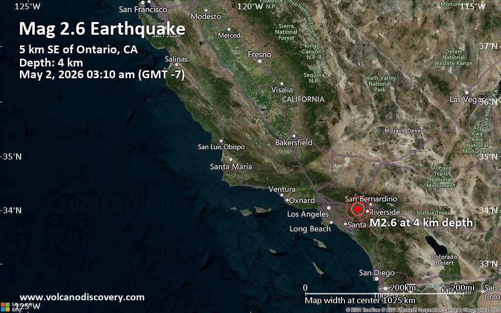 An earthquake of magnitude 2.6 occurred early morning on Saturday, May 2nd, 2026, at 3:10 am local time near Ontario, San Bernardino County, California, USA, as reported by the United States Geological Survey.
According to preliminary data, the quake was located at a very shallow depth of 2.8 miles. Shallow earthquakes are felt more strongly than deeper ones as they are closer to the surface. The exact magnitude, epicenter, and depth of the quake might be revised within the next few hours or minutes as seismologists review data and refine their calculations, or as other agencies issue their report.
A second report was later issued by The Incorporated Research Institutions for Seismology (IRIS), which listed it as a magnitude 2.6 earthquake as well. A third agency, the European-Mediterranean Seismological Centre (EMSC), reported the same quake at magnitude 2.5.
Towns or cities near the epicenter where the quake might have been felt as very weak shaking include Ontario (pop. 171,200) located 4 miles from the epicenter, Eastvale (pop. 59,000) 4 miles away, Chino (pop. 85,600) 5 miles away, Rancho Cucamonga (pop. 175,200) 6 miles away, Upland (pop. 76,400) 6 miles away, and Pomona (pop. 153,300) 9 miles away. In Fontana (pop. 212,700, 10 miles away), Corona (pop. 164,200, 10 miles away), and Anaheim (pop. 350,700, 23 miles away), the quake was probably not felt.
Earthquake data: Date & time: May 2, 2026 03:10 am (GMT -7) local time (2 May 2026 10:10 GMT)Magnitude: 2.6 Depth: 4.43 km Epicenter latitude / longitude: 34.02°N / 117.59°W  ( San Bernardino County, California, United States) Primary data source: USGShttps://www.volcanodiscovery.com/earthquake/news/301265/Magnitude-26-earthquake-strikes-near-Ontario-San-Bernardino-County-California-USA.html
0
18
Read More
|
|
Forums60
Topics771,307
Posts806,094
Members2,958
| |
Most Online17,963
Jan 15th, 2026
|
|
|
|
|
Copyright 1996 - 2026 by David Cottle. Designed by David Bate Jr. All Rights Reserved.
By using this forum, the user agrees not to transfer any data or technical information received under the agreement, to any other entity without the express approval of the AUS-CITY Forum Admins and/or authors of individual posts (Forum Admins and DoD/USSPACECOM for the analysis of satellite tracking data).
Two-line elements (TLE) and all other satellite data presented and distributed via this forum and e-mail lists of AUS-CITY are distributed with permission from DoD/USSTRATCOM.


Reprise Hosting

|

|


 - Click image for larger picture.")


