|
|
|
0 members (),
1,879
guests, and
19
robots. |
|
Key:
Admin,
Global Mod,
Mod
|
|
S |
M |
T |
W |
T |
F |
S |
|
|
|
|
1
|
2
|
3
|
4
|
|
5
|
6
|
7
|
8
|
9
|
10
|
11
|
|
12
|
13
|
14
|
15
|
16
|
17
|
18
|
|
19
|
20
|
21
|
22
|
23
|
24
|
25
|
|
26
|
27
|
28
|
29
|
30
|
|
|
|
There are no members with birthdays on this day. |

#779626
Sun 26 Oct 2025 05:13:PM
|
Joined: Feb 2001
Posts: 381,904
Launch Director
|
OP

Launch Director
Joined: Feb 2001
Posts: 381,904 |
Significant magnitude 6.2 quake hits 57 km northwest of Kefamenanu, Indonesia early morning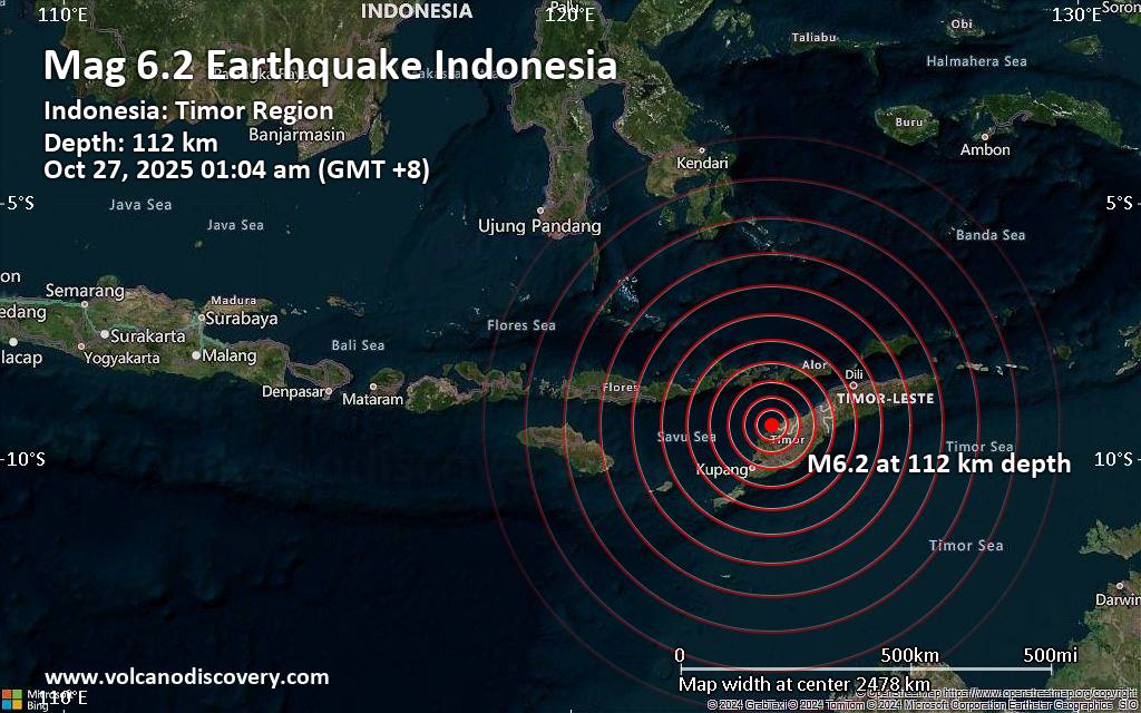 An intermediate magnitude 6.2 earthquake was reported early morning near Kefamenanu, North Central Timor Regency, East Nusa Tenggara, Indonesia.
According to Indonesia's Meteorology, Climatology, and Geophysical Agency, the quake hit on Monday, October 27th, 2025, at 1:04 am local time at an intermediate depth of 112. km. The strength of the earthquake may have been tempered by its relative great depth below the surface, which makes it feel weaker in absolute terms. The exact magnitude, epicenter, and depth of the quake might be revised within the next few hours or minutes as seismologists review data and refine their calculations, or as other agencies issue their report.
Our monitoring service identified a second report from the European-Mediterranean Seismological Centre (EMSC) which listed the quake at magnitude 6.2 as well. Other agencies reporting the same quake include the citizen-seismograph network of RaspberryShake at magnitude 6.2, and the German Research Centre for Geosciences (GFZ) at magnitude 6.2.
Generally quakes of this magnitude are recorded by more than one agency and the results can vary, with subsequent reports that come in after the first one often showing more accuracy.
Based on the preliminary seismic data, the quake was probably felt by many people in the area of the epicenter. It should not have caused significant damage, other than objects falling from shelves, broken windows, etc.
In Naisano Dua (pop. 2,300) located 36 km from the epicenter, Kefamenanu (pop. 48,200) 57 km away, Soe (pop. 40,200) 67 km away, Kupang (pop. 442,800) 101 km away, and Atambua (pop. 82,200) 105 km away, the quake should have been felt as light shaking.
VolcanoDiscovery will automatically update magnitude and depth if these change and follow up if other significant news about the quake become available. If you’re in the area, please send us your experience through our reporting mechanism, either online or via our mobile app. This will help us provide more first-hand updates to anyone around the globe who wants to know more about this quake.
Earthquake data: Date & time: Oct 27, 2025 01:04 am (Makassar time) local time (26 Oct 2025 17:04 GMT)Magnitude: 6.2 Depth: 112.00 km Epicenter latitude / longitude: 9.34°S / 123.97°E  (Kupang Regency, East Nusa Tenggara, Indonesia) Primary data source: BMKGhttps://www.volcanodiscovery.com/earthquake/news/284954/Significant-magnitude-62-quake-hits-57-km-northwest-of-Kefamenanu-Indonesia-early-morning-.html
|
|


CMS The Best Conveyancing solicitors conveyancing quotes throughout the UK
For any webhosting enquiries please email webmaster@aus-city.com
|
|
Entire Thread
|
 Significant magnitude 6.2 quake hits 57 km northwest of Kefamenanu, Indonesia early morning
|
Webmaster
|
Sun 26 Oct 2025 05:13:PM
|
|
Forums60
Topics770,087
Posts804,863
Members2,958
| |
Most Online17,963
Jan 15th, 2026
|
|
|
|
|
Copyright 1996 - 2026 by David Cottle. Designed by David Bate Jr. All Rights Reserved.
By using this forum, the user agrees not to transfer any data or technical information received under the agreement, to any other entity without the express approval of the AUS-CITY Forum Admins and/or authors of individual posts (Forum Admins and DoD/USSPACECOM for the analysis of satellite tracking data).
Two-line elements (TLE) and all other satellite data presented and distributed via this forum and e-mail lists of AUS-CITY are distributed with permission from DoD/USSTRATCOM.

Reprise Hosting

|

|


 - Click image for larger picture.")


