|
|
|
0 members (),
1,914
guests, and
31
robots. |
|
Key:
Admin,
Global Mod,
Mod
|
|
S |
M |
T |
W |
T |
F |
S |
|
|
1
|
2
|
3
|
4
|
5
|
6
|
|
7
|
8
|
9
|
10
|
11
|
12
|
13
|
|
14
|
15
|
16
|
17
|
18
|
19
|
20
|
|
21
|
22
|
23
|
24
|
25
|
26
|
27
|
|
28
|
29
|
30
|
|
|
|
|
|
There are no members with birthdays on this day. |

Volcano earthquake report for Friday, 19 Jun 2026
• Moderate mag. 4.0 earthquake - 231 km southwest of Invercargill, Southland,...
• Moderate mag. 4.8 earthquake - St. Helena: Central Mid-Atlantic Ridge on Fr...
• Moderate mag. 4.0 earthquake - Badakhshan, 193 km northeast of Kabul, Kabul...
• Moderate mag. 4.5 earthquake - 25 km east of Kuhdasht, Lorestan Province, I...
• Light mag. 3.9 earthquake - 14 km east of Takayama, Gifu, Japan, on Friday,...
|

#792306
Mon 12 Jan 2026 02:50:AM
|
Joined: Feb 2001
Posts: 678,976
Launch Director
|
OP

Launch Director
Joined: Feb 2001
Posts: 678,976 |
Volcano earthquake report for Monday, 12 Jan 2026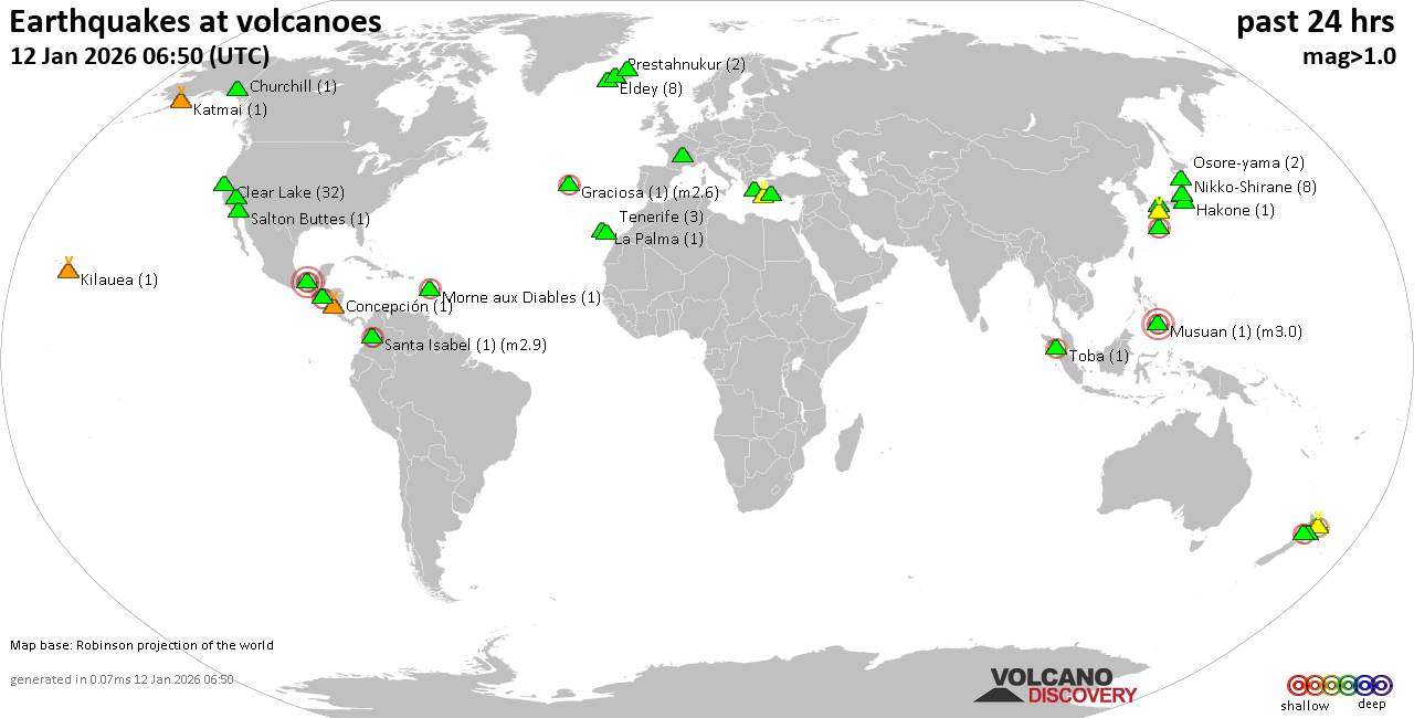 World map showing volcanoes with shallow (less than 50 km) earthquakes within 20 km radius during the past 24 hours on 12 Jan 2026 Number in brackets indicate nr of quakes. Quakes detected near: Abu (1 quake mag 1.0), Akagi (1 quake mag 1.6), Akuseki-jima (1 quake mag 2.9), Aso (9 quakes between mag 0.1-1.1), Bibinoi (1 quake mag 2.5), Chaîne des Puys (1 quake mag 1.9)
Churchill (1 quake mag 1.6), Clear Lake (31 quakes between mag 0.2-1.7), Colima (1 quake mag 3.0), Concepción (1 quake mag 1.8), Coso (2 quakes between mag 0.5-1.7), El Chichón (14 quakes between mag 1.9-2.8), Eldey (18 quakes between mag 0.5-1.9), Etna (1 quake mag 1.4), Fagradalsfjall (2 quakes between mag 0.1-1.8), Graciosa (1 quake mag 2.6), Hakkoda (1 quake mag 3.0), Hakone (1 quake mag 1.1), Hrómundartindur (5 quakes between mag 0.2-1.5), Katmai (1 quake mag 1.1), Kilauea (3 quakes between mag 1.7-1.9), La Palma (1 quake mag 1.3), Lipari (1 quake mag 2.4), Maunaloa (1 quake mag 1.7), Morne Plat Pays (1 quake mag 1.4), Morne aux Diables (1 quake mag 2.5), Musuan (1 quake mag 3.0), Nikko-Shirane (3 quakes between mag 0.6-1.2), Osore-yama (2 quakes between mag 0.7-1.5), Prestahnukur (2 quakes between mag 1.1-1.2), Ruapehu (1 quake mag 1.3), Salton Buttes (2 quakes between mag 1.4-1.6), Santa Isabel (1 quake mag 1.9), Santorini (2 quakes between mag 1.7-3.6), Sousaki (4 quakes between mag 1.6-2.0), Svartsengi (2 quakes between mag 0.6-1.0), Taranaki (1 quake mag 2.4), Tenerife (4 quakes between mag 0.8-1.2), Tjörnes Fracture Zone (2 quakes between mag 0.8-1.2), Toba (1 quake mag 2.3), Whale Island (1 quake mag 2.3) (updated 02h50)
Note: Earthquakes within 20 km from and at depths less than 50 km under active volcanoes are reported. The list is not complete because many volcanoes are not monitored and/or seismic data in high resolution is not available publicly.
Volcanoes with recent earthquakes above magnitude 2 or more than 10 quakes are listed below:
Akuseki-jima volcano (Ryukyu Islands): magnitude 2.9 earthquakeA magnitude 2.9 earthquake occurred at the volcano 9 hours ago. The quake, which might be volcanic in origin, was located at a depth of 0 km depth at 9 km distance SSE from the volcano. Earthquake details: 2.9 quake East China Sea, Kagoshima-ken, 30 km south of Suwanose-jima Island, Japan, Jan 12, 2026 02:41 am (GMT +9) (9 km SSE) All earthquakes at Akuseki-jimaBibinoi volcano (Halmahera): magnitude 2.5 earthquakeA magnitude 2.5 earthquake occurred at the volcano 21 hours ago. The quake, which might be volcanic in origin, was located at a depth of 2.00 km depth at 17 km distance NNW from the volcano. Earthquake details: 2.5 quake 22 km east of Labuha, Kabupaten Halmahera Selatan, North Maluku, Indonesia, Jan 11, 2026 02:32 pm (GMT +9) (17 km NNW) All earthquakes at BibinoiClear Lake volcano (California): 31 earthquakes up to magnitude 1.7Possible earthquake swarm: 31 earthquakes occurred near (under) the volcano during 23 hours, the last being recorded quake 1 hour 24 minutes ago. Hypocenter depths ranged between 3.41 and 0.57 km. Earthquake details: (only 5 largest) 1.7 quake Sonoma County, 13 mi southwest of Clearlake, Lake County, California, United States, Jan 11, 2026 04:40 pm (GMT -8) (17 km S) 1.6 quake 29 mi north of Santa Rosa, Sonoma County, California, United States, Jan 11, 2026 03:36 pm (GMT -8) (17 km SSW) 1.3 quake 27 mi north of Santa Rosa, Sonoma County, California, United States, Jan 11, 2026 12:30 pm (GMT -8) (17 km S) 1.3 quake 28 mi north of Santa Rosa, Sonoma County, California, United States, Jan 10, 2026 07:59 pm (GMT -8) (16 km SSW) 1.3 quake 28 mi north of Santa Rosa, Sonoma County, California, United States, Jan 11, 2026 05:05 pm (GMT -8) (16 km SSW) All earthquakes at Clear LakeColima volcano (Western & Central Mexico): magnitude 3.0 earthquakeA magnitude 3.0 earthquake occurred at the volcano 22 hours ago. The quake, which might be volcanic in origin, was located at a depth of 26.20 km depth at 17 km distance WNW from the volcano. Earthquake details: 3.0 quake 35 km southwest of Ciudad Guzman, Estado de Jalisco, Mexico, Jan 10, 2026 10:28 pm (GMT -6) (17 km WNW) All earthquakes at ColimaEl Chichón volcano (Southern Mexico): 14 earthquakes up to magnitude 2.8Possible earthquake swarm: 14 earthquakes occurred near (under) the volcano during 13 hours, the last being recorded quake 10 hours ago. Hypocenter depths ranged between 3.00 and 2.40 km. Earthquake details: (only 5 largest) 2.8 quake Estado de Chiapas, 36 km southwest of Teapa, Estado de Tabasco, Mexico, Jan 11, 2026 10:11 am (GMT -6) (1 km NNE) 2.7 quake Estado de Chiapas, 36 km southwest of Teapa, Estado de Tabasco, Mexico, Jan 11, 2026 04:45 am (GMT -6) (1 km N) 2.6 quake Estado de Chiapas, 38 km southwest of Teapa, Estado de Tabasco, Mexico, Jan 10, 2026 10:27 pm (GMT -6) (1 km SW) 2.5 quake Estado de Chiapas, 37 km southwest of Teapa, Estado de Tabasco, Mexico, Jan 11, 2026 09:07 am (GMT -6) (3 km NW) 2.5 quake Estado de Chiapas, 37 km southwest of Teapa, Estado de Tabasco, Mexico, Jan 11, 2026 10:34 am (GMT -6) (0 km NW) All earthquakes at El ChichónEldey volcano (Iceland): 18 earthquakes up to magnitude 1.9Possible earthquake swarm: 18 earthquakes occurred near (under) the volcano during 10 hours, the last being recorded quake 12 hours ago. Hypocenter depths ranged between 17.50 and 1.10 km. Earthquake details: (only 5 largest) 1.9 quake Iceland: 13.7 km S of Eldeyjardrangur Jan 11, 2026 06:08 am (Reykjavik time) (14 km S) 1.7 quake Iceland: 12.8 km SSE of Geirfuglasker Jan 11, 2026 06:19 am (Reykjavik time) (16 km SSW) 1.6 quake Iceland: 13.6 km SSE of Geirfuglasker Jan 11, 2026 06:05 am (Reykjavik time) (18 km SSW) 1.4 quake Iceland: 15.9 km SSE of Geirfuglasker Jan 11, 2026 06:12 am (Reykjavik time) (18 km S) 1.4 quake Iceland: 5.2 km SSE of Geirfuglasker Jan 11, 2026 06:57 am (Reykjavik time) (13 km SW) All earthquakes at EldeyEldey is located at the beginning of the Reykjanes Ridge off the SW tip of Iceland. Its highest elevation is the top of Eldey Island, but most of the volcanic edifice is submerged. Several eruptions occurred in historic times, last in 1926. Graciosa volcano (Azores): magnitude 2.6 earthquakeA magnitude 2.6 earthquake occurred at the volcano 4 hours ago. The quake, which might be volcanic in origin, was located at a depth of 4.50 km depth at 9 km distance WNW from the volcano. Earthquake details: 2.6 quake 6 km southwest of Santa Cruz da Graciosa, Azores, Portugal, Jan 11, 2026 09:29 pm (GMT -1) (9 km WNW) All earthquakes at GraciosaHakkoda volcano (Honshu): magnitude 3.0 earthquakeA magnitude 3.0 earthquake occurred at the volcano 21 hours ago. The quake, which might be volcanic in origin, was located at a depth of 10.00 km depth at 10 km distance SSE from the volcano. Earthquake details: Reported seismic-like event (likely no quake): 32 km southeast of Aomori, Aomori, Japan, Jan 11, 2026 02:34 pm (GMT +9) (10 km SSE) All earthquakes at HakkodaLipari volcano (Eolian Islands): magnitude 2.4 earthquakeA magnitude 2.4 earthquake occurred at the volcano 22 hours ago. The quake, which might be volcanic in origin, was located at a depth of 10.30 km depth at 12 km distance W from the volcano. Earthquake details: 2.4 quake Tyrrhenian Sea, 9.4 km southwest of Isola Salina Island, Sicily, Italy, Jan 11, 2026 05:44 am (GMT +1) (12 km W) All earthquakes at LipariMorne aux Diables volcano (Caribbean): magnitude 2.5 earthquakeA magnitude 2.5 earthquake occurred at the volcano 18 hours ago. The quake, which might be volcanic in origin, was located at a depth of 11.60 km depth at 18 km distance NW from the volcano. Earthquake details: 2.5 quake Caribbean Sea, 39 km northwest of Dominica Island, Dominica, Jan 11, 2026 04:43 am (GMT -4) (18 km NW) All earthquakes at Morne aux DiablesMusuan volcano (Mindanao): magnitude 3.0 earthquakeA magnitude 3.0 earthquake occurred at the volcano 13 hours ago. The quake, which might be volcanic in origin, was located at a depth of 10.00 km depth at 6 km distance WSW from the volcano. Earthquake details: Reported seismic-like event (likely no quake): 16 km northwest of Quezon, Province of Bukidnon, Northern Mindanao, Philippines, Jan 11, 2026 09:51 pm (GMT +8) (6 km WSW) All earthquakes at MusuanSantorini volcano (Greece): 2 earthquakes up to magnitude 3.62 earthquakes occurred near (under) the volcano during 9 hours, the last being recorded quake 11 hours ago. Hypocenter depths ranged between 12.40 and 10.62 km. Earthquake details: 3.6 quake Aegean Sea, 4.4 km east of Santorini Island, Greece, Jan 11, 2026 09:09 am (GMT +2) (10 km E) 1.7 quake 3.7 km southeast of Fira, Nomos Kykladon, South Aegean, Greece, Jan 11, 2026 06:00 pm (GMT +2) (6 km E) All earthquakes at SantoriniTaranaki volcano (North Island): magnitude 2.4 earthquakeA magnitude 2.4 earthquake occurred at the volcano 19 hours ago. The quake, which might be volcanic in origin, was located at a depth of 9.60 km depth at 9 km distance SE from the volcano. Earthquake details: 2.4 quake 32 km south of New Plymouth, Taranaki, New Zealand, Jan 11, 2026 08:43 pm (GMT +13) (9 km SE) All earthquakes at TaranakiToba volcano (Sumatra): magnitude 2.3 earthquakeA magnitude 2.3 earthquake occurred at the volcano 8 hours ago. The quake, which might be volcanic in origin, was located at a depth of 21.00 km depth at 14 km distance NW from the volcano. Earthquake details: 2.3 quake 14 km west of Nainggolan, Kabupaten Samosir, North Sumatra, Indonesia, Jan 12, 2026 01:28 am (GMT +7) (14 km NW) All earthquakes at TobaWhale Island volcano (New Zealand): magnitude 2.3 earthquakeA magnitude 2.3 earthquake occurred at the volcano 44 minutes ago. The quake, which might be volcanic in origin, was located at a depth of 31.70 km depth at 9 km distance SSE from the volcano. Earthquake details: 2.3 quake South Pacific Ocean, 4.6 km northeast of Whakatane, Bay of Plenty, New Zealand, Jan 12, 2026 03:06 pm (GMT +13) (9 km SSE) All earthquakes at Whale Islandhttps://www.volcanodiscovery.com/earthquakes-volcanoes/news/291728/Volcano-earthquake-report-for-Monday-12-Jan-2026.html
|
|


CMS The Best Conveyancing solicitors conveyancing quotes throughout the UK
For any webhosting enquiries please email webmaster@aus-city.com
|
|
Entire Thread
|
 Volcano earthquake report for Monday, 12 Jan 2026
|
Webmaster
|
Mon 12 Jan 2026 02:50:AM
|
|
Forums60
Topics783,058
Posts817,818
Members2,960
| |
Most Online22,463
May 9th, 2026
|
|
|
|
|
Copyright 1996 - 2026 by David Cottle. Designed by David Bate Jr. All Rights Reserved.
By using this forum, the user agrees not to transfer any data or technical information received under this agreement to any other entity without the express approval of the AUS-CITY Forum Admins and/or authors of individual posts (Forum Admins and DoD/USSPACECOM for the analysis of satellite tracking data).
Two-line elements (TLE) and all other satellite data presented and distributed via this forum and AUS-CITY mailing lists are distributed with permission from DoD/USSTRATCOM.

|

|


 - Click image for larger picture.")


