|
|
|
0 members (),
620
guests, and
21
robots. |
|
Key:
Admin,
Global Mod,
Mod
|
|
S |
M |
T |
W |
T |
F |
S |
|
|
|
|
1
|
2
|
3
|
4
|
|
5
|
6
|
7
|
8
|
9
|
10
|
11
|
|
12
|
13
|
14
|
15
|
16
|
17
|
18
|
|
19
|
20
|
21
|
22
|
23
|
24
|
25
|
|
26
|
27
|
28
|
29
|
30
|
|
|
|
There are no members with birthdays on this day. |

#793244
Fri 16 Jan 2026 01:50:AM
|
Joined: Feb 2001
Posts: 381,904
Launch Director
|
OP

Launch Director
Joined: Feb 2001
Posts: 381,904 |
Volcano earthquake report for Friday, 16 Jan 2026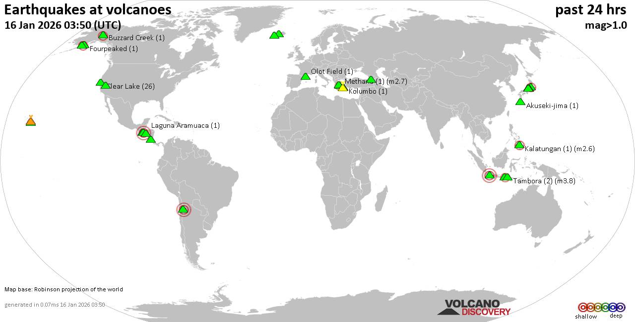 World map showing volcanoes with shallow (less than 50 km) earthquakes within 20 km radius during the past 24 hours on 16 Jan 2026 Number in brackets indicate nr of quakes. Quakes detected near: Abu (3 quakes between mag 0.6-1.0), Akuseki-jima (1 quake mag 1.3), Brennisteinsfjöll (2 quakes between mag 0.8-1.0), Buzzard Creek (1 quake mag 2.1), Cerro Singüil (1 quake mag 3.0), Clear Lake (25 quakes between mag 0.4-2.1)
Denison (1 quake mag 2.0), Fourpeaked (1 quake mag 1.7), Geureudong (1 quake mag 2.7), Gran Canaria (1 quake mag 1.3), Hiuchi (4 quakes between mag 0.3-2.0), Hofsjökull (1 quake mag 1.6), Kalatungan (1 quake mag 2.6), Kars (1 quake mag 1.3), Kilauea (25 quakes between mag 0.7-1.8), Kolumbo (2 quakes between mag 1.0-1.3), Laguna Aramuaca (1 quake mag 2.2), Loihi (2 quakes between mag 2.0-2.3), Long Valley (1 quake mag 1.0), Methana (1 quake mag 2.7), Moyuta (2 quakes between mag 2.5-3.3), Norikura (6 quakes between mag 0.3-3.1), Olot Field (1 quake mag 1.1), Papandayan (1 quake mag 3.3), Rinjani (1 quake mag 2.4), Santorini (1 quake mag 2.1), Snowy Mountain (1 quake mag 2.0), Socompa (1 quake mag 3.0), Sousaki (2 quakes between mag 1.6-1.6), Svartsengi (4 quakes between mag 0.6-1.2), Tambora (3 quakes between mag 2.2-3.8), Tenorio (1 quake mag 1.8), Washiba-Kumonotaira (372 quakes between mag 0.1-4.7), Yake-dake (1 quake mag 5.1), Öraefajökull (12 quakes between mag 0.6-1.1) (updated 01h50)
Note: Earthquakes within 20 km from and at depths less than 50 km under active volcanoes are reported. The list is not complete because many volcanoes are not monitored and/or seismic data in high resolution is not available publicly.
Volcanoes with recent earthquakes above magnitude 2 or more than 10 quakes are listed below:
Buzzard Creek volcano (Eastern Alaska): magnitude 2.1 earthquakeA magnitude 2.1 earthquake occurred at the volcano 3 hours ago. The quake, which might be volcanic in origin, was located at a depth of 5.00 km depth at 18 km distance WSW from the volcano. Earthquake details: 2.1 quake 12 mi northeast of Healy, Denali Borough, Alaska, United States, Jan 15, 2026 01:29 pm (GMT -9) (18 km WSW) All earthquakes at Buzzard CreekCerro Singüil volcano (El Salvador): magnitude 3.0 earthquakeA magnitude 3.0 earthquake occurred at the volcano 19 hours ago. The quake, which might be volcanic in origin, was located at a depth of 10.00 km depth at 8 km distance SSE from the volcano. Earthquake details: Reported seismic-like event (likely no quake): 8.6 km west of Santa Ana, Departamento de Santa Ana, El Salvador, Jan 15, 2026 01:19 am (GMT -6) (8 km SSE) All earthquakes at Cerro SingüilClear Lake volcano (California): 25 earthquakes up to magnitude 2.1Possible earthquake swarm: 25 earthquakes occurred near (under) the volcano during 20 hours, the last being recorded quake 2 hours ago. Hypocenter depths ranged between 3.35 and 0.58 km. Earthquake details: (only 5 largest) 2.1 quake 12 mi southwest of Clearlake, Lake County, California, United States, Jan 15, 2026 09:11 am (GMT -8) (15 km S) 2.0 quake Sonoma County, 13 mi southwest of Clearlake, Lake County, California, United States, Jan 15, 2026 06:04 am (GMT -8) (16 km SSW) 1.9 quake 12 mi southwest of Clearlake, Lake County, California, United States, Jan 15, 2026 09:11 am (GMT -8) (15 km S) 1.5 quake 26 mi north of Santa Rosa, Sonoma County, California, United States, Jan 14, 2026 07:57 pm (GMT -8) (17 km S) 1.3 quake 26 mi north of Santa Rosa, Sonoma County, California, United States, Jan 14, 2026 07:57 pm (GMT -8) (17 km S) All earthquakes at Clear LakeGeureudong volcano (Sumatra): magnitude 2.7 earthquakeA magnitude 2.7 earthquake occurred at the volcano 24 hours ago. The quake, which might be volcanic in origin, was located at a depth of 3.00 km depth at 3 km distance W from the volcano. Earthquake details: 2.7 quake Kabupaten Bener Meriah, 61 km southwest of Lhokseumawe, Indonesia, Jan 15, 2026 09:18 am (GMT +7) (3 km W) All earthquakes at GeureudongKalatungan volcano (Mindanao): magnitude 2.6 earthquakeA magnitude 2.6 earthquake occurred at the volcano 10 hours ago. The quake, which might be volcanic in origin, was located at a depth of 10.00 km depth at 16 km distance WSW from the volcano. Earthquake details: 2.6 quake 40 km west of Maramag, Province of Bukidnon, Northern Mindanao, Philippines, Jan 15, 2026 11:24 pm (GMT +8) (16 km WSW) All earthquakes at KalatunganKilauea volcano (Hawai'i (Big Island)): 25 earthquakes up to magnitude 1.8Possible earthquake swarm: 25 earthquakes occurred near (under) the volcano during 1 hour 17 minutes, the last being recorded quake 19 hours ago. Hypocenter depths ranged between 5.92 and 0.15 km. Earthquake details: (only 5 largest) 1.8 quake 27 mi southwest of Hilo, Hawaii County, Hawaii, United States, Jan 14, 2026 07:56 pm (GMT -10) (2 km SSW) 1.8 quake 3.4 mi southwest of Volcano, Hawaii County, Hawaii, United States, Jan 14, 2026 07:49 pm (GMT -10) (2 km E) 1.8 quake 3.9 mi southwest of Volcano, Hawaii County, Hawaii, United States, Jan 14, 2026 07:37 pm (GMT -10) (1 km E) 1.8 quake 25 mi southwest of Hilo, Hawaii County, Hawaii, United States, Jan 14, 2026 07:46 pm (GMT -10) (2 km E) 1.8 quake 25 mi southwest of Hilo, Hawaii County, Hawaii, United States, Jan 14, 2026 08:06 pm (GMT -10) (2 km E) All earthquakes at KilaueaLaguna Aramuaca volcano (El Salvador): magnitude 2.2 earthquakeA magnitude 2.2 earthquake occurred at the volcano 9 hours ago. The quake, which might be volcanic in origin, was located at a depth of 5.00 km depth at 15 km distance SSE from the volcano. Earthquake details: 2.2 quake 21 km west of La Union, Departamento de La Union, El Salvador, Jan 15, 2026 10:30 am (GMT -6) (15 km SSE) All earthquakes at Laguna AramuacaLoihi volcano (Hawai'i (Big Island)): 2 earthquakes up to magnitude 2.32 earthquakes occurred near (under) the volcano during 19 hours, the last being recorded quake 12 minutes ago. Hypocenter depths ranged between 37.26 and 9.60 km. Earthquake details: 2.3 quake North Pacific Ocean, 60 mi south of Hilo, Hawaii County, Hawaii, United States, Jan 14, 2026 08:20 pm (GMT -10) (18 km ESE) 2.0 quake North Pacific Ocean, 41 mi southeast of of Hawai‘i Island, Hawaii County, Hawaii, United States, Jan 15, 2026 03:37 pm (GMT -10) (16 km NW) All earthquakes at LoihiMethana volcano (Greece): magnitude 2.7 earthquakeA magnitude 2.7 earthquake occurred at the volcano 20 hours ago. The quake, which might be volcanic in origin, was located at a depth of 36.00 km depth at 13 km distance NNW from the volcano. Earthquake details: 2.7 quake Aegean Sea, 17 km west of Aegina Island, Nomos Attikis, Attica, Greece, Jan 15, 2026 07:20 am (GMT +2) (13 km NNW) All earthquakes at MethanaMoyuta volcano (Guatemala): 2 earthquakes up to magnitude 3.32 earthquakes occurred near (under) the volcano during 5 hours, the last being recorded quake 16 hours ago. Hypocenter depths ranged between 10.00 and 9.00 km. Earthquake details: 3.3 quake 29 km southeast of Cuilapa, Departamento de Santa Rosa, Guatemala, Jan 15, 2026 03:33 am (GMT -6) (7 km NW) 2.5 quake 29 km southeast of Cuilapa, Departamento de Santa Rosa, Guatemala, Jan 14, 2026 10:21 pm (GMT -6) (6 km NW) All earthquakes at MoyutaNorikura volcano (Honshu): 6 earthquakes up to magnitude 3.16 earthquakes occurred near (under) the volcano during 16 hours, the last being recorded quake 4 hours ago. Hypocenter depths ranged between 8.00 and 5.00 km. Earthquake details: (only 5 largest) 3.1 quake 34 km southwest of Azumino, Nagano, Japan, Jan 15, 2026 02:49 pm (GMT +9) (3 km N) 1.0 quake 18 km southeast of Takayama, Gifu, Japan, Jan 15, 2026 08:07 pm (GMT +9) (14 km WSW) 0.7 quake 33 km east of Takayama, Gifu, Japan, Jan 16, 2026 06:38 am (GMT +9) (8 km SSE) 0.6 quake 18 km southeast of Takayama, Gifu, Japan, Jan 15, 2026 08:19 pm (GMT +9) (14 km WSW) 0.4 quake 18 km southeast of Takayama, Gifu, Japan, Jan 15, 2026 08:51 pm (GMT +9) (14 km WSW) All earthquakes at NorikuraPapandayan volcano (West Java): magnitude 3.3 earthquakeA magnitude 3.3 earthquake occurred at the volcano 20 hours ago. The quake, which might be volcanic in origin, was located at a depth of 10.00 km depth at 19 km distance W from the volcano. Earthquake details: 3.3 quake Kabupaten Garut, 22 km southeast of Banjar, Indonesia, Jan 15, 2026 12:39 pm (GMT +7) (19 km W) All earthquakes at PapandayanRinjani volcano (Lombok): magnitude 2.4 earthquakeA magnitude 2.4 earthquake occurred at the volcano 16 hours ago. The quake, which might be volcanic in origin, was located at a depth of 14.00 km depth at 15 km distance ENE from the volcano. Earthquake details: 2.4 quake 30 km north of Selong, Kabupaten Lombok Timur, West Nusa Tenggara, Indonesia, Jan 15, 2026 05:44 pm (GMT +8) (15 km ENE) All earthquakes at RinjaniSantorini volcano (Greece): magnitude 2.1 earthquakeA magnitude 2.1 earthquake occurred at the volcano 4 hours ago. The quake, which might be volcanic in origin, was located at a depth of 20.60 km depth at 4 km distance SSW from the volcano. Earthquake details: 2.1 quake Aegean Sea, 7.8 km southwest of Santorini Island, Greece, Jan 15, 2026 11:45 pm (GMT +2) (4 km SSW) All earthquakes at SantoriniSocompa volcano (Northern Chile, Bolivia and Argentina): magnitude 3.0 earthquakeA magnitude 3.0 earthquake occurred at the volcano 9 hours ago. The quake, which might be volcanic in origin, was located at a depth of 10.00 km depth at 13 km distance ESE from the volcano. Earthquake details: Reported seismic-like event (likely no quake): Region de Antofagasta, Chile, Jan 15, 2026 01:28 pm (GMT -3) (13 km ESE) All earthquakes at SocompaTambora volcano (Sumbawa): 3 earthquakes up to magnitude 3.83 earthquakes occurred near (under) the volcano during 6 hours, the last being recorded quake 17 hours ago. Hypocenter depths ranged between 23.00 and 11.00 km. Earthquake details: 3.8 quake 51 km northwest of Dompu, Kabupaten Dompu, West Nusa Tenggara, Indonesia, Jan 15, 2026 04:55 pm (GMT +8) (12 km SSE) 2.3 quake 51 km west of Dompu, Kabupaten Dompu, West Nusa Tenggara, Indonesia, Jan 15, 2026 04:52 pm (GMT +8) (14 km SSE) 2.2 quake 59 km northwest of Dompu, Kabupaten Dompu, West Nusa Tenggara, Indonesia, Jan 15, 2026 11:12 am (GMT +8) (8 km SSW) All earthquakes at TamboraWashiba-Kumonotaira volcano (Honshu): 372 earthquakes up to magnitude 4.7Possible earthquake swarm: 372 earthquakes occurred near (under) the volcano during 19 hours, the last being recorded quake 1 hour 20 minutes ago. Hypocenter depths ranged between 10.60 and 0.00 km. Earthquake details: (only 5 largest) 4.7 quake 23 km west of Azumino, Nagano, Japan, Jan 15, 2026 02:40 pm (GMT +9) (5 km SSE) 4.3 quake 48 km southeast of Toyama, Toyama, Japan, Jan 15, 2026 02:43 pm (GMT +9) (1 km SSE) 3.5 quake 29 km northwest of Azumino, Nagano, Japan, Jan 15, 2026 02:57 pm (GMT +9) (1 km SSE) 2.8 quake Gifu, 26 km west of Azumino, Nagano, Japan, Jan 15, 2026 02:51 pm (GMT +9) (6 km SSE) 2.8 quake 24 km west of Azumino, Nagano, Japan, Jan 15, 2026 02:49 pm (GMT +9) (7 km SSE) All earthquakes at Washiba-KumonotairaYake-dake volcano (Honshu): magnitude 5.1 earthquakeA magnitude 5.1 earthquake occurred at the volcano 20 hours ago. The quake, which might be volcanic in origin, was located at a depth of 6.74 km depth at 13 km distance ESE from the volcano. Earthquake details: 5.1 quake 17 km southwest of Azumino, Nagano, Japan, Jan 15, 2026 02:48 pm (GMT +9) (13 km ESE) All earthquakes at Yake-dakeÖraefajökull volcano (Iceland): 12 earthquakes up to magnitude 1.1Possible earthquake swarm: 12 earthquakes occurred near (under) the volcano during 3 hours, the last being recorded quake 21 hours ago. Hypocenter depths ranged between 11.00 and 0.90 km. Earthquake details: (only 5 largest) 1.1 quake 4.6 km SSE of Hvannadalshnjúkur Jan 15, 2026 02:16 am (Universal Time) (3 km S) 1.0 quake 4.1 km SSE of Hvannadalshnjúkur Jan 15, 2026 02:14 am (Universal Time) (2 km S) 0.9 quake 3.8 km SSE of Hvannadalshnjúkur Jan 15, 2026 01:58 am (Universal Time) (2 km S) 0.8 quake 4.3 km SSE of Hvannadalshnjúkur Jan 15, 2026 01:59 am (Universal Time) (2 km S) 0.8 quake 4.5 km SSE of Hvannadalshnjúkur Jan 15, 2026 02:39 am (Universal Time) (2 km S) All earthquakes at Öraefajökullhttps://www.volcanodiscovery.com/earthquakes-volcanoes/news/292026/Volcano-earthquake-report-for-Friday-16-Jan-2026.html
|
|


CMS The Best Conveyancing solicitors conveyancing quotes throughout the UK
For any webhosting enquiries please email webmaster@aus-city.com
|
|
Entire Thread
|
 Volcano earthquake report for Friday, 16 Jan 2026
|
Webmaster
|
Fri 16 Jan 2026 01:50:AM
|
|
Forums60
Topics767,704
Posts802,467
Members2,958
| |
Most Online17,963
Jan 15th, 2026
|
|
|
|
|
Copyright 1996 - 2026 by David Cottle. Designed by David Bate Jr. All Rights Reserved.
By using this forum, the user agrees not to transfer any data or technical information received under the agreement, to any other entity without the express approval of the AUS-CITY Forum Admins and/or authors of individual posts (Forum Admins and DoD/USSPACECOM for the analysis of satellite tracking data).
Two-line elements (TLE) and all other satellite data presented and distributed via this forum and e-mail lists of AUS-CITY are distributed with permission from DoD/USSTRATCOM.

Reprise Hosting

|

|


 - Click image for larger picture.")


