|
|
|
1 members (Alisa),
2,596
guests, and
21
robots. |
|
Key:
Admin,
Global Mod,
Mod
|
|
S |
M |
T |
W |
T |
F |
S |
|
|
1
|
2
|
3
|
4
|
5
|
6
|
|
7
|
8
|
9
|
10
|
11
|
12
|
13
|
|
14
|
15
|
16
|
17
|
18
|
19
|
20
|
|
21
|
22
|
23
|
24
|
25
|
26
|
27
|
|
28
|
29
|
30
|
|
|
|
|
|
There are no members with birthdays on this day. |

Volcano earthquake report for Friday, 5 Jun 2026
• Small magnitude 3.1 earthquake 11 miles southwest of Pukatja, South Austral...
• Moderate mag. 4.2 earthquake - 40 km west of Matias Romero Avendano, Estado...
• World Earthquake Report for Friday, 5 June 2026
• Magnitude 3.8 earthquake strikes near Carlsbad, Eddy County, New Mexico, US...
• Moderate mag. 4.7 earthquake - North Pacific Ocean, 244 km southeast of Hac...
|

#795231
Sun 25 Jan 2026 11:50:AM
|
Joined: Feb 2001
Posts: 381,904
Launch Director
|
OP

Launch Director
Joined: Feb 2001
Posts: 381,904 |
Volcano earthquake report for Sunday, 25 Jan 2026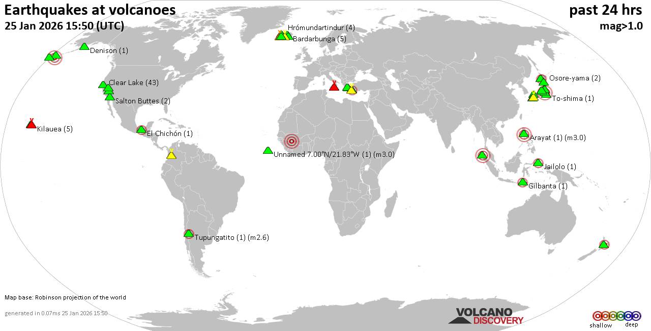 World map showing volcanoes with shallow (less than 50 km) earthquakes within 20 km radius during the past 24 hours on 25 Jan 2026 Number in brackets indicate nr of quakes. Quakes detected near: Aso (9 quakes between mag 0.4-2.6), Bardarbunga (5 quakes between mag 0.3-1.1), Brennisteinsfjöll (3 quakes between mag 0.4-1.4), Clear Lake (38 quakes between mag 0.2-1.6), Denison (1 quake mag 1.5), Eldey (2 quakes between mag 0.7-1.6)
Etna (10 quakes between mag 0.9-2.5), Geureudong (1 quake mag 3.0), Gilbanta (1 quake mag 2.1), Hiuchi (2 quakes between mag 0.3-1.1), Hrómundartindur (4 quakes between mag 0.5-1.5), Hualalai (1 quake mag 1.9), Jailolo (1 quake mag 2.5), Katla (1 quake mag 1.3), Kilauea (5 quakes between mag 1.7-2.2), Kolumbo (5 quakes between mag 1.4-2.1), Ljósufjöll (4 quakes between mag 0.3-1.7), Loihi (1 quake mag 1.8), Long Valley (2 quakes between mag 1.4-1.4), Machin (5 quakes between mag 1.0-2.9), Makushin (1 quake mag 3.9), Methana (1 quake mag 1.2), Mt Fuji (1 quake mag 3.0), Nevado del Ruiz (1 quake mag 1.1), Ontake-san (3 quakes between mag 0.5-3.3), Osore-yama (2 quakes between mag 0.4-2.1), Salton Buttes (2 quakes between mag 1.1-1.6), Santorini (1 quake mag 1.7), Sousaki (1 quake mag 2.1), Tana (1 quake mag 2.7), Taupo (2 quakes between mag 2.2-2.4), Thordarhyrna (2 quakes between mag 1.3-2.8), To-shima (1 quake mag 1.0), Tupungatito (1 quake mag 2.6), Washiba-Kumonotaira (5 quakes between mag 0.5-1.4), Öraefajökull (1 quake mag 1.5) (updated 11h50)
Note: Earthquakes within 20 km from and at depths less than 50 km under active volcanoes are reported. The list is not complete because many volcanoes are not monitored and/or seismic data in high resolution is not available publicly.
Volcanoes with recent earthquakes above magnitude 2 or more than 10 quakes are listed below:
Aso volcano (Kyushu): 9 earthquakes up to magnitude 2.69 earthquakes occurred near (under) the volcano during 7 hours, the last being recorded quake 13 hours ago. Hypocenter depths ranged between 11.00 and 6.00 km. Earthquake details: (only 5 largest) 2.6 quake 5.2 km northeast of Aso, Kumamoto, Japan, Jan 25, 2026 12:25 am (GMT +9) (11 km N) 2.2 quake 6.2 km north of Aso, Kumamoto, Japan, Jan 25, 2026 12:27 am (GMT +9) (12 km N) 2.2 quake 3.2 km northeast of Aso, Kumamoto, Japan, Jan 25, 2026 12:20 am (GMT +9) (9 km N) 2.1 quake 5.2 km northeast of Aso, Kumamoto, Japan, Jan 25, 2026 12:31 am (GMT +9) (11 km N) 1.4 quake 5.4 km northeast of Aso, Kumamoto, Japan, Jan 25, 2026 12:25 am (GMT +9) (11 km N) All earthquakes at AsoClear Lake volcano (California): 38 earthquakes up to magnitude 1.6Possible earthquake swarm: 38 earthquakes occurred near (under) the volcano during 24 hours, the last being recorded quake 10 minutes ago. Hypocenter depths ranged between 12.81 and 0.77 km. Earthquake details: (only 5 largest) 1.6 quake 12 mi southwest of Clearlake, Lake County, California, United States, Jan 24, 2026 11:17 pm (GMT -8) (15 km S) 1.6 quake Sonoma County, 13 mi southwest of Clearlake, Lake County, California, United States, Jan 25, 2026 12:48 am (GMT -8) (17 km S) 1.4 quake 27 mi north of Santa Rosa, Sonoma County, California, United States, Jan 24, 2026 07:26 pm (GMT -8) (18 km SSW) 1.3 quake 28 mi north of Santa Rosa, Sonoma County, California, United States, Jan 24, 2026 05:00 pm (GMT -8) (16 km SSW) 1.2 quake 28 mi north of Santa Rosa, Sonoma County, California, United States, Jan 25, 2026 02:19 am (GMT -8) (16 km SSW) All earthquakes at Clear LakeEtna volcano (Italy): 10 earthquakes up to magnitude 2.510 earthquakes occurred near (under) the volcano during 11 hours, the last being recorded quake 51 minutes ago. Hypocenter depths ranged between 14.50 and 6.28 km. Earthquake details: (only 5 largest) 2.5 quake 8.4 km north of Adrano, Catania, Sicily, Italy, Jan 25, 2026 08:51 am (GMT +1) (14 km W) 1.9 quake 8.3 km north of Adrano, Catania, Sicily, Italy, Jan 25, 2026 11:59 am (GMT +1) (14 km W) 1.7 quake 8 km north of Adrano, Catania, Sicily, Italy, Jan 25, 2026 11:10 am (GMT +1) (17 km W) 1.6 quake 8.1 km north of Adrano, Catania, Sicily, Italy, Jan 25, 2026 10:17 am (GMT +1) (13 km W) 1.6 quake 5.2 km south of Bronte, Catania, Sicily, Italy, Jan 25, 2026 01:28 am (GMT +1) (15 km W) All earthquakes at EtnaGeureudong volcano (Sumatra): magnitude 3.0 earthquakeA magnitude 3.0 earthquake occurred at the volcano 3 hours ago. The quake, which might be volcanic in origin, was located at a depth of 10.00 km depth at 8 km distance ESE from the volcano. Earthquake details: Reported seismic-like event (likely no quake): 57 km southwest of Lhokseumawe, Indonesia, Jan 25, 2026 04:17 pm (GMT +7) (8 km ESE) All earthquakes at GeureudongGilbanta volcano (Lesser Sunda Islands): magnitude 2.1 earthquakeA magnitude 2.1 earthquake occurred at the volcano 9 hours ago. The quake, which might be volcanic in origin, was located at a depth of 12.00 km depth at 6 km distance NNW from the volcano. Earthquake details: 2.1 quake Flores Sea, 6.9 km north of Gili Banta Island, West Nusa Tenggara, Indonesia, Jan 25, 2026 10:26 am (GMT +8) (6 km NNW) All earthquakes at GilbantaJailolo volcano (Halmahera): magnitude 2.5 earthquakeA magnitude 2.5 earthquake occurred at the volcano 10 hours ago. The quake, which might be volcanic in origin, was located at a depth of 5.00 km depth at 8 km distance N from the volcano. Earthquake details: 2.5 quake Maluku Sea, 40 km north of Ternate, Kota Ternate, North Maluku, Indonesia, Jan 25, 2026 10:30 am (GMT +9) (8 km N) All earthquakes at JailoloKilauea volcano (Hawai'i (Big Island)): 5 earthquakes up to magnitude 2.25 earthquakes occurred near (under) the volcano during 7 hours, the last being recorded quake 5 hours ago. Hypocenter depths ranged between 29.37 and 0.48 km. Earthquake details: 2.2 quake 31 mi south of Hilo, Hawaii County, Hawaii, United States, Jan 24, 2026 01:02 pm (GMT -10) (10 km S) 1.9 quake 31 mi south of Hilo, Hawaii County, Hawaii, United States, Jan 24, 2026 01:35 pm (GMT -10) (11 km S) 1.7 quake 3.3 mi southwest of Volcano, Hawaii County, Hawaii, United States, Jan 24, 2026 08:28 pm (GMT -10) (2 km ENE) 1.7 quake 7.8 mi northeast of Pāhala, Hawaii County, Hawaii, United States, Jan 24, 2026 07:05 pm (GMT -10) (18 km SW) 1.7 quake 31 mi south of Hilo, Hawaii County, Hawaii, United States, Jan 24, 2026 03:37 pm (GMT -10) (14 km SE) All earthquakes at KilaueaKolumbo volcano (Greece): 5 earthquakes up to magnitude 2.15 earthquakes occurred near (under) the volcano during 8 hours, the last being recorded quake 5 hours ago. Hypocenter depths ranged between 11.20 and 5.00 km. Earthquake details: 2.1 quake Aegean Sea, 28 km east of Nisi Ios Island, Nomos Kykladon, South Aegean, Greece, Jan 25, 2026 03:41 am (GMT +2) (17 km NE) 1.7 quake Aegean Sea, 32 km northeast of Oia, Nomos Kykladon, South Aegean, Greece, Jan 25, 2026 12:25 am (GMT +2) (18 km NE) 1.6 quake Aegean Sea, 28 km northeast of Santorini Island, Greece, Jan 25, 2026 01:28 am (GMT +2) (16 km NE) 1.5 quake Aegean Sea, 20 km northeast of Santorini Island, Greece, Jan 25, 2026 06:16 am (GMT +2) (10 km ENE) 1.4 quake Aegean Sea, 20 km northeast of Santorini Island, Greece, Jan 25, 2026 08:31 am (GMT +2) (9 km ENE) All earthquakes at KolumboMachin volcano (Colombia): 5 earthquakes up to magnitude 2.95 earthquakes occurred near (under) the volcano during 15 hours, the last being recorded quake 9 hours ago. Hypocenter depths ranged between 10.00 and 1.00 km. Earthquake details: 2.9 quake 9.8 km northeast of Anaime, Departamento de Tolima, Colombia, Jan 24, 2026 07:10 am (GMT -5) (3 km SSE) 2.9 quake 20 km west of Ibague, Departamento de Tolima, Colombia, Jan 24, 2026 07:10 am (GMT -5) (3 km SSE) 2.0 quake 20 km west of Ibague, Departamento de Tolima, Colombia, Jan 24, 2026 09:33 pm (GMT -5) (2 km SSE) 1.6 quake 20 km west of Ibague, Departamento de Tolima, Colombia, Jan 24, 2026 09:33 pm (GMT -5) (2 km SE) 1.0 quake 26 km west of Ibague, Departamento de Tolima, Colombia, Jan 24, 2026 07:01 am (GMT -5) (5 km NW) All earthquakes at MachinMakushin volcano (Aleutian Islands): magnitude 3.9 earthquakeA magnitude 3.9 earthquake occurred at the volcano 19 hours ago. The quake, which might be volcanic in origin, was located at a depth of 8.40 km depth at 13 km distance S from the volcano. Earthquake details: 3.9 quake Bering Sea, 58 mi south of Unalaska Island, Aleutians West Census Area, Alaska, United States, Jan 24, 2026 07:50 am (GMT -9) (13 km S) All earthquakes at MakushinMt Fuji volcano (Honshu): magnitude 3.0 earthquakeA magnitude 3.0 earthquake occurred at the volcano 20 hours ago. The quake, which might be volcanic in origin, was located at a depth of 10.00 km depth at 16 km distance NE from the volcano. Earthquake details: Reported seismic-like event (likely no quake): 36 km southeast of Kofu, Yamanashi, Japan, Jan 25, 2026 01:10 am (GMT +9) (16 km NE) All earthquakes at Mt FujiOntake-san volcano (Honshu): 3 earthquakes up to magnitude 3.33 earthquakes occurred near (under) the volcano during 14 hours, the last being recorded quake 5 hours ago. Hypocenter depths ranged between 7.00 and 0.00 km. Earthquake details: 3.3 quake 35 km west of Ina, Nagano, Japan, Jan 25, 2026 03:42 pm (GMT +9) (8 km ESE) 3.3 quake 33 km west of Ina, Nagano, Japan, Jan 25, 2026 03:43 pm (GMT +9) (11 km E) 0.5 quake 30 km west of Ina, Nagano, Japan, Jan 25, 2026 02:02 am (GMT +9) (13 km E) All earthquakes at Ontake-sanOsore-yama volcano (Honshu): 2 earthquakes up to magnitude 2.12 earthquakes occurred near (under) the volcano during 33 minutes, the last being recorded quake 16 hours ago. Hypocenter depths ranged between 11.40 and 8.60 km. Earthquake details: 2.1 quake 8.5 km south of Ninohe, Iwate, Japan, Jan 25, 2026 04:00 am (GMT +9) (17 km ESE) 0.4 quake 8.3 km south of Ninohe, Iwate, Japan, Jan 25, 2026 04:33 am (GMT +9) (17 km ESE) All earthquakes at Osore-yamaSousaki volcano (Greece): magnitude 2.1 earthquakeA magnitude 2.1 earthquake occurred at the volcano 16 hours ago. The quake, which might be volcanic in origin, was located at a depth of 10.00 km depth at 9 km distance S from the volcano. Earthquake details: 2.1 quake Aegean Sea, 16 km southeast of Corinth, Nomos Korinthias, Peloponnese, Greece, Jan 24, 2026 10:03 pm (GMT +2) (9 km S) All earthquakes at SousakiTana volcano (Aleutian Islands): magnitude 2.7 earthquakeA magnitude 2.7 earthquake occurred at the volcano 12 hours ago. The quake, which might be volcanic in origin, was located at a depth of 0.64 km depth at 7 km distance NNE from the volcano. Earthquake details: 2.7 quake Bering Sea, 4.2 mi northeast of Chuginadak Island, Aleutians West Census Area, Alaska, United States, Jan 24, 2026 01:45 pm (GMT -10) (7 km NNE) All earthquakes at TanaTaupo volcano (New Zealand): 2 earthquakes up to magnitude 2.42 earthquakes occurred near (under) the volcano during 9 minutes, the last being recorded quake 9 hours ago. Hypocenter depths ranged between 5.00 and 4.80 km. Earthquake details: 2.4 quake 2.4 km north of Taupo, Waikato, New Zealand, Jan 25, 2026 03:32 pm (GMT +13) (19 km NNE) 2.2 quake 2.4 km north of Taupo, Waikato, New Zealand, Jan 25, 2026 03:23 pm (GMT +13) (19 km NNE) All earthquakes at TaupoThordarhyrna volcano (Iceland): 2 earthquakes up to magnitude 2.82 earthquakes occurred near (under) the volcano during 2 minutes, the last being recorded quake 24 hours ago. Hypocenter depths ranged between 2.60 and 2.10 km. Earthquake details: 2.8 quake South, 208 km east of Reykjavik, Capital Region, Iceland, Jan 24, 2026 11:59 am (Universal Time) (1 km E) 1.3 quake 22.6 km SW of Grímsfjall Jan 24, 2026 12:02 pm (Universal Time) (1 km SE) All earthquakes at ThordarhyrnaTupungatito volcano (Central Chile and Argentina): magnitude 2.6 earthquakeA magnitude 2.6 earthquake occurred at the volcano 16 hours ago. The quake, which might be volcanic in origin, was located at a depth of 10.90 km depth at 7 km distance W from the volcano. Earthquake details: 2.6 quake Cordillera, 72 km east of Santiago, Santiago, Santiago Metropolitan, Chile, Jan 24, 2026 05:19 pm (GMT -3) (7 km W) All earthquakes at Tupungatitohttps://www.volcanodiscovery.com/earthquakes-volcanoes/news/292872/Volcano-earthquake-report-for-Sunday-25-Jan-2026.html
|
|


CMS The Best Conveyancing solicitors conveyancing quotes throughout the UK
For any webhosting enquiries please email webmaster@aus-city.com
|
|
Entire Thread
|
 Volcano earthquake report for Sunday, 25 Jan 2026
|
Webmaster
|
Sun 25 Jan 2026 11:50:AM
|
|
Forums60
Topics779,336
Posts814,131
Members2,960
| |
Most Online22,463
May 9th, 2026
|
|
|
|
|
Copyright 1996 - 2026 by David Cottle. Designed by David Bate Jr. All Rights Reserved.
By using this forum, the user agrees not to transfer any data or technical information received under this agreement to any other entity without the express approval of the AUS-CITY Forum Admins and/or authors of individual posts (Forum Admins and DoD/USSPACECOM for the analysis of satellite tracking data).
Two-line elements (TLE) and all other satellite data presented and distributed via this forum and AUS-CITY mailing lists are distributed with permission from DoD/USSTRATCOM.

|

|


 - Click image for larger picture.")


