|
|
|
0 members (),
1,877
guests, and
21
robots. |
|
Key:
Admin,
Global Mod,
Mod
|
|
S |
M |
T |
W |
T |
F |
S |
|
|
|
|
1
|
2
|
3
|
4
|
|
5
|
6
|
7
|
8
|
9
|
10
|
11
|
|
12
|
13
|
14
|
15
|
16
|
17
|
18
|
|
19
|
20
|
21
|
22
|
23
|
24
|
25
|
|
26
|
27
|
28
|
29
|
30
|
31
|
|
|
There are no members with birthdays on this day. |
|
|
|
|
|
|
|
|
|
|
|
|
|
|
|
|
|
|
|
|
|
|
by Webmaster - Sun 26 Jul 2026 08:45:PM
|

World Earthquake Report for Sunday, 26 July 2026
• Moderate mag. 4.5 earthquake - Estado de Veracruz-Llave, Mexico, on 2026-07...
• Volcano earthquake report for Sunday, 26 Jul 2026
• Moderate mag. 4.0 earthquake - Kabupaten Kepulauan Talaud, 148 km northeast...
• Light mag. 3.9 earthquake - North Pacific Ocean, 65 km south of Puerto San ...
• Strong mag. 5.4 earthquake - Northern Mid-Atlantic Ridge on Sunday, Jul 26,...
|

#798024
Fri 13 Feb 2026 12:01:AM
|
Joined: Feb 2001
Posts: 678,976
Launch Director
|
OP

Launch Director
Joined: Feb 2001
Posts: 678,976 |
Small magnitude 3.9 quake hits 54 miles southwest of Atka, Alaska, United States around noon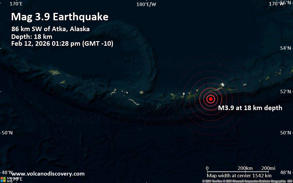 An earthquake of magnitude 3.9 occurred around noon on Thursday, February 12th, 2026, at 1:28 pm local time near Atka, Aleutians West, Alaska, USA, as reported by the United States Geological Survey.
According to preliminary data, the quake was located at a shallow depth of 11 miles. Shallow earthquakes are felt more strongly than deeper ones as they are closer to the surface. Magnitude and other quake parameters can still change in the coming hours as the agency continues to process seismic data.
Our monitoring service identified a second report from The Incorporated Research Institutions for Seismology (IRIS) which listed the quake at magnitude 3.9 as well. A third agency, the European-Mediterranean Seismological Centre (EMSC), reported the same quake at magnitude 3.9.
Towns or cities near the epicenter where the quake might have been felt as very weak shaking include Atka (pop. 64) located 54 miles from the epicenter.
Earthquake data: Date & time: Feb 12, 2026 01:28 pm (GMT -10) local time (12 Feb 2026 23:28 GMT)Magnitude: 3.9 Depth: 18.45 km Epicenter latitude / longitude: 51.64°N / 175.07°W  ( Alaska, United States) Primary data source: USGShttps://www.volcanodiscovery.com/earthquake/news/294719/Small-magnitude-39-quake-hits-54-miles-southwest-of-Atka-Alaska-United-States-around-noon-.html
|
|


CMS The Best Conveyancing solicitors conveyancing quotes throughout the UK
For any webhosting enquiries please email webmaster@aus-city.com
|
|
Entire Thread
|
 Small magnitude 3.9 quake hits 54 miles southwest of Atka, Alaska, United States around noon
|
Webmaster
|
Fri 13 Feb 2026 12:01:AM
|
|
Forums60
Topics792,815
Posts827,597
Members2,960
| |
Most Online102,106
Jul 10th, 2026
|
|
|
|
|
Copyright 1996 - 2026 by David Cottle. Designed by David Bate Jr. All Rights Reserved.
By using this forum, the user agrees not to transfer any data or technical information received under this agreement to any other entity without the express approval of the AUS-CITY Forum Admins and/or authors of individual posts (Forum Admins and DoD/USSPACECOM for the analysis of satellite tracking data).
Two-line elements (TLE) and all other satellite data presented and distributed via this forum and AUS-CITY mailing lists are distributed with permission from DoD/USSTRATCOM.

|

|


 - Click image for larger picture.")


