|
|
|
0 members (),
607
guests, and
35
robots. |
|
Key:
Admin,
Global Mod,
Mod
|
|
S |
M |
T |
W |
T |
F |
S |
|
|
1
|
2
|
3
|
4
|
5
|
6
|
|
7
|
8
|
9
|
10
|
11
|
12
|
13
|
|
14
|
15
|
16
|
17
|
18
|
19
|
20
|
|
21
|
22
|
23
|
24
|
25
|
26
|
27
|
|
28
|
29
|
30
|
|
|
|
|
|
There are no members with birthdays on this day. |

Volcano earthquake report for Thursday, 11 Jun 2026
• Moderate mag. 4.6 earthquake - South Pacific Ocean, Bay of Plenty, 354 km n...
• Moderate magnitude 4.9 earthquake 92 km southwest of Bima, Indonesia
• Moderate mag. 4.4 earthquake - Indian Ocean, 84 km south of Dompu, Indonesi...
• Strong mag. 5.5 earthquake - Philippine Sea, 144 km north of Sangihe Besar ...
• World Earthquake Report for Wednesday, 10 June 2026
|

#798507
Mon 16 Feb 2026 12:52:PM
|
Joined: Feb 2001
Posts: 678,976
Launch Director
|
OP

Launch Director
Joined: Feb 2001
Posts: 678,976 |
Magnitude 2.8 earthquake strikes near Katanning, Western Australia, Australia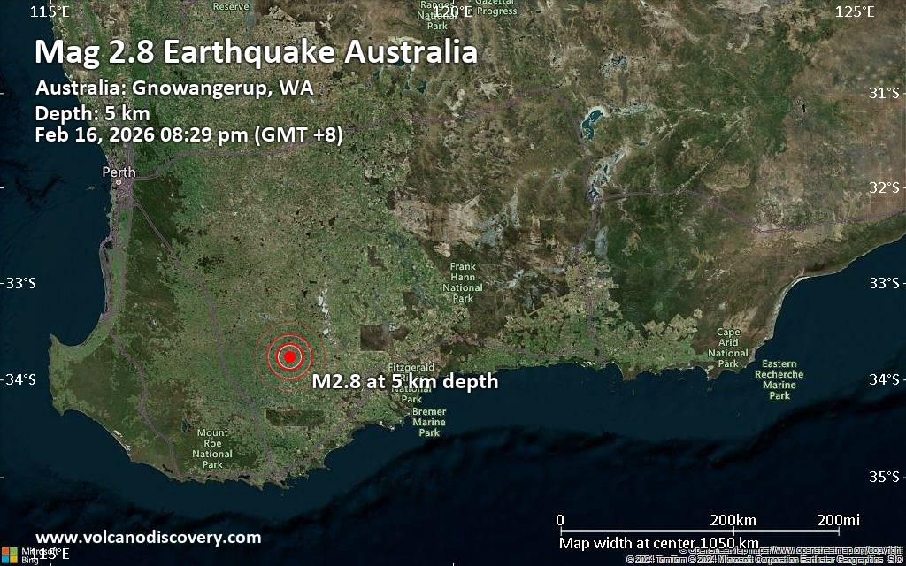 An earthquake of magnitude 2.8 occurred only 22 minutes ago 25 miles southeast of Katanning, Western Australia, Australia, Geoscience Australia (GeoAu) reported.
The quake hit at a very shallow depth of 3.1 miles beneath the epicenter near Katanning, Western Australia, Australia, in the evening on Monday, February 16th, 2026, at 8:29 pm local time. The exact magnitude, epicenter, and depth of the quake might be revised within the next few hours or minutes as seismologists review data and refine their calculations, or as other agencies issue their report.
A second report was later issued by the citizen-seismograph network of RaspberryShake, which listed it as a magnitude 2.8 earthquake as well. A third agency, the European-Mediterranean Seismological Centre (EMSC), reported the same quake at magnitude 2.8.
Towns or cities near the epicenter where the quake might have been felt as very weak shaking include Pallinup (pop. 78) located 10 miles from the epicenter, Coyrecup (pop. 42) 10 miles away, Jackitup (pop. 60) 11 miles away, and Gnowangerup (pop. 590) 12 miles away. In Nyabing (pop. 290, 18 miles away), Broomehill (pop. 380, 20 miles away), and Katanning (pop. 3,700, 25 miles away), the quake was probably not felt.
Earthquake data: Date & time: Feb 16, 2026 08:29 pm (GMT +8) local time (16 Feb 2026 12:29 GMT)Magnitude: 2.8 Depth: 5.00 km Epicenter latitude / longitude: 33.77°S / 117.98°E  ( Kent Shire, Australia) Primary data source: GeoAuhttps://www.volcanodiscovery.com/earthquake/news/295053/Magnitude-28-earthquake-strikes-near-Katanning-Western-Australia-Australia.html
|
|


CMS The Best Conveyancing solicitors conveyancing quotes throughout the UK
For any webhosting enquiries please email webmaster@aus-city.com
|
|
Entire Thread
|
 Magnitude 2.8 earthquake strikes near Katanning, Western Australia, Australia
|
Webmaster
|
Mon 16 Feb 2026 12:52:PM
|
|
Forums60
Topics780,487
Posts815,245
Members2,960
| |
Most Online22,463
May 9th, 2026
|
|
|
|
|
Copyright 1996 - 2026 by David Cottle. Designed by David Bate Jr. All Rights Reserved.
By using this forum, the user agrees not to transfer any data or technical information received under this agreement to any other entity without the express approval of the AUS-CITY Forum Admins and/or authors of individual posts (Forum Admins and DoD/USSPACECOM for the analysis of satellite tracking data).
Two-line elements (TLE) and all other satellite data presented and distributed via this forum and AUS-CITY mailing lists are distributed with permission from DoD/USSTRATCOM.

|

|


 - Click image for larger picture.")


