|
|
|
0 members (),
1,802
guests, and
29
robots. |
|
Key:
Admin,
Global Mod,
Mod
|
|
S |
M |
T |
W |
T |
F |
S |
|
1
|
2
|
3
|
4
|
5
|
6
|
7
|
|
8
|
9
|
10
|
11
|
12
|
13
|
14
|
|
15
|
16
|
17
|
18
|
19
|
20
|
21
|
|
22
|
23
|
24
|
25
|
26
|
27
|
28
|
|
There are no members with birthdays on this day. |
|
|
|
|
SPC MD 102
by Webmaster - Fri 20 Feb 2026 12:15:AM
|
SPC MD 103
by Webmaster - Fri 20 Feb 2026 12:15:AM
|
SPC MD 104
by Webmaster - Fri 20 Feb 2026 12:15:AM
|
|
|
|
|
|
|
|
|
|
|
|
|
Joined: Feb 2001
Posts: 381,904
Launch Director
|
OP

Launch Director
Joined: Feb 2001
Posts: 381,904 |
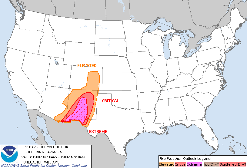
SPC Day 2 Fire Weather OutlookSPC Day 2 Fire Weather Outlook 
Day 2 Fire Weather Outlook
NWS Storm Prediction Center Norman OK
0138 PM CST Thu Feb 19 2026

Valid 201200Z - 211200Z

...CRITICAL FIRE WEATHER AREA FOR EASTERN NEW MEXICO INTO WESTERN
TEXAS...

...Southern High Plains...
An embedded mid-level short wave impulse and attendant 90+ kt jet
will eject into the Southern Plains Friday. The strong westerly flow
along with subsequent lee surface trough development will support
dry, downslope flow across much of Southern High Plains.
West-southwest winds of 20-25 mph with relative humidity dropping
into 15-20% range across eastern NM and west TX will yield critical
fire weather conditions for the region. Warmer and drier conditions
are expected across the Trans Pecos and TX Big Bend areas, where
afternoon relative humidity will likely fall below 10% by peak
heating. Expanded Critical Highlights into portions far west TX
where sustained westerly winds of around 20 mph, very low relative
humidity and receptive fuels align to support wildfire spread.

..Williams/Garcia.. 02/19/2026

.PREV DISCUSSION... /ISSUED 0139 AM CST Thu Feb 19 2026/

...Synopsis...
The next in a series of mid-level impulses embedded in broader upper
troughing will overspread the southern Plains, resulting in surface
low development across the southern High Plains tomorrow (Friday).
As the low tracks eastward, dry westerly flow will promote wildfire
spread conditions. The latest guidance consensus depicts 20-25 mph
sustained westerly surface winds coinciding with 15 percent RH by
afternoon peak heating, warranting the introduction of Critical
highlights.

...Please see www.spc.noaa.gov/fire for graphic product...
Read morehttps://www.spc.noaa.gov/products/fire_wx/fwdy2.html
|
|


CMS The Best Conveyancing solicitors conveyancing quotes throughout the UK
For any webhosting enquiries please email webmaster@aus-city.com
|
|
Entire Thread
|

 SPC Day 2 Fire Weather Outlook
|
Webmaster
|
Yesterday at 07:39 PM
|
|
Forums60
Topics762,368
Posts797,098
Members2,957
| |
Most Online17,963
Jan 15th, 2026
|
|
|
|
|
Copyright 1996 - 2026 by David Cottle. Designed by David Bate Jr. All Rights Reserved.
By using this forum, the user agrees not to transfer any data or technical information received under the agreement, to any other entity without the express approval of the AUS-CITY Forum Admins and/or authors of individual posts (Forum Admins and DoD/USSPACECOM for the analysis of satellite tracking data).
Two-line elements (TLE) and all other satellite data presented and distributed via this forum and e-mail lists of AUS-CITY are distributed with permission from DoD/USSTRATCOM.


Reprise Hosting


|

|