|
|
|
0 members (),
1,095
guests, and
21
robots. |
|
Key:
Admin,
Global Mod,
Mod
|
|
S |
M |
T |
W |
T |
F |
S |
|
1
|
2
|
3
|
4
|
5
|
6
|
7
|
|
8
|
9
|
10
|
11
|
12
|
13
|
14
|
|
15
|
16
|
17
|
18
|
19
|
20
|
21
|
|
22
|
23
|
24
|
25
|
26
|
27
|
28
|
|
29
|
30
|
31
|
|
|
|
|
|
There are no members with birthdays on this day. |

#802330
Thu 12 Mar 2026 11:50:PM
|
Joined: Feb 2001
Posts: 381,904
Launch Director
|
OP

Launch Director
Joined: Feb 2001
Posts: 381,904 |
Volcano earthquake report for Thursday, 12 Mar 2026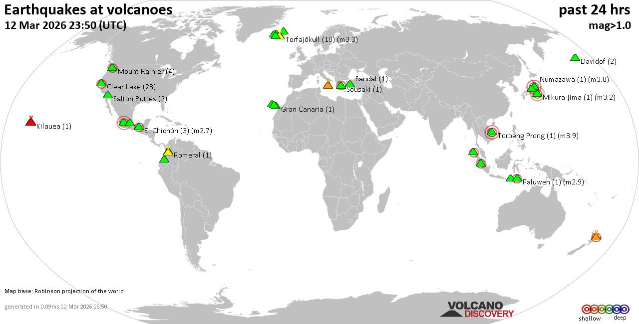 World map showing volcanoes with shallow (less than 50 km) earthquakes within 20 km radius during the past 24 hours on 12 Mar 2026 Number in brackets indicate nr of quakes. Quakes detected near: Azufral (1 quake mag 1.6), Clear Lake (28 quakes between mag 0.1-2.2), Davidof (2 quakes between mag 1.0-1.3), El Chichón (3 quakes between mag 2.2-2.7), Etna (2 quakes between mag 0.6-1.2), Geureudong (6 quakes between mag 2.3-3.8)
Gran Canaria (1 quake mag 1.6), Katla (4 quakes between mag 0.4-1.2), Kilauea (1 quake mag 1.7), Krísuvík (7 quakes between mag 0.0-1.2), La Palma (1 quake mag 1.8), Ljósufjöll (2 quakes between mag 0.2-1.0), Machin (1 quake mag 1.7), Mauna Kea (1 quake mag 1.8), Maunaloa (2 quakes between mag 1.0-1.9), Michoacán-Guanajuato (1 quake mag 3.1), Mikura-jima (1 quake mag 3.2), Mount Rainier (4 quakes between mag 0.7-2.2), Numazawa (1 quake mag 3.0), Paluweh (1 quake mag 2.9), Papayo (1 quake mag 3.0), Romeral (1 quake mag 2.0), Salton Buttes (2 quakes between mag 0.9-1.0), Sandal (1 quake mag 1.2), Snaefellsjökull (2 quakes between mag 0.0-1.6), Sousaki (1 quake mag 2.0), Talang (1 quake mag 2.8), Tambora (1 quake mag 2.2), Tenerife (5 quakes between mag 0.8-1.5), Tjörnes Fracture Zone (3 quakes between mag 0.8-1.7), Torfajökull (18 quakes between mag 0.1-3.3), Toroeng Prong (1 quake mag 3.9), Washiba-Kumonotaira (5 quakes between mag 2.5-4.1), White Island (1 quake mag 2.4) (updated 23h50)
Note: Earthquakes within 20 km from and at depths less than 50 km under active volcanoes are reported. The list is not complete because many volcanoes are not monitored and/or seismic data in high resolution is not available publicly.
Volcanoes with recent earthquakes above magnitude 2 or more than 10 quakes are listed below:
Clear Lake volcano (California): 28 earthquakes up to magnitude 2.2Possible earthquake swarm: 28 earthquakes occurred near (under) the volcano during 22 hours, the last being recorded quake 1 hour 46 minutes ago. Hypocenter depths ranged between 10.78 and 1.40 km. Earthquake details: (only 5 largest) 2.2 quake Sonoma County, 14 mi southwest of Clearlake, Lake County, California, United States, Mar 11, 2026 09:07 pm (GMT -7) (17 km SSW) 1.4 quake Lake County, 28 mi north of Santa Rosa, Sonoma County, California, United States, Mar 12, 2026 09:32 am (GMT -7) (15 km S) 1.3 quake 28 mi north of Santa Rosa, Sonoma County, California, United States, Mar 11, 2026 10:28 pm (GMT -7) (17 km SSW) 1.2 quake 27 mi north of Santa Rosa, Sonoma County, California, United States, Mar 12, 2026 03:21 am (GMT -7) (17 km S) 1.1 quake Lake County, 26 mi north of Santa Rosa, Sonoma County, California, United States, Mar 12, 2026 12:48 am (GMT -7) (17 km S) All earthquakes at Clear LakeEl Chichón volcano (Southern Mexico): 3 earthquakes up to magnitude 2.73 earthquakes occurred near (under) the volcano during 6 hours, the last being recorded quake 16 hours ago. Hypocenter depths ranged between 3.00 and 2.40 km. Earthquake details: 2.7 quake Estado de Chiapas, 37 km southwest of Teapa, Estado de Tabasco, Mexico, Mar 12, 2026 01:09 am (GMT -6) (1 km WSW) 2.3 quake Estado de Chiapas, 37 km southwest of Teapa, Estado de Tabasco, Mexico, Mar 11, 2026 08:14 pm (GMT -6) (1 km NNW) 2.2 quake Estado de Chiapas, 37 km southwest of Teapa, Estado de Tabasco, Mexico, Mar 12, 2026 01:57 am (GMT -6) (1 km NNW) All earthquakes at El ChichónGeureudong volcano (Sumatra): 6 earthquakes up to magnitude 3.86 earthquakes occurred near (under) the volcano during 6 hours, the last being recorded quake 8 hours ago. Hypocenter depths ranged between 11.00 and 4.00 km. Earthquake details: (only 5 largest) 3.8 quake Kabupaten Bener Meriah, 33 km south of Bireun, Indonesia, Mar 12, 2026 04:44 pm (GMT +7) (17 km NNW) 2.7 quake Kabupaten Bener Meriah, 35 km south of Bireun, Indonesia, Mar 12, 2026 04:54 pm (GMT +7) (15 km NNW) 2.5 quake Kabupaten Bener Meriah, 35 km southeast of Bireun, Indonesia, Mar 12, 2026 05:03 pm (GMT +7) (16 km N) 2.4 quake Kabupaten Bener Meriah, 32 km south of Bireun, Indonesia, Mar 12, 2026 05:53 pm (GMT +7) (18 km N) 2.3 quake Kabupaten Bener Meriah, 62 km southwest of Lhokseumawe, Indonesia, Mar 12, 2026 10:27 pm (GMT +7) (6 km S) All earthquakes at GeureudongMichoacán-Guanajuato volcano (Western & Central Mexico): magnitude 3.1 earthquakeA magnitude 3.1 earthquake occurred at the volcano 20 hours ago. The quake, which might be volcanic in origin, was located at a depth of 13.10 km depth at 10 km distance SSE from the volcano. Earthquake details: 3.1 quake 18 km west of Uruapan, Estado de Michoacan de Ocampo, Mexico, Mar 11, 2026 09:46 pm (GMT -6) (10 km SSE) All earthquakes at Michoacán-GuanajuatoMikura-jima volcano (Izu Islands): magnitude 3.2 earthquakeA magnitude 3.2 earthquake occurred at the volcano 11 hours ago. The quake, which might be volcanic in origin, was located at a depth of 19.20 km depth at 19 km distance W from the volcano. Earthquake details: 3.2 quake Philippine Sea, 29 km south of Miyake, Tokyo, Japan, Mar 12, 2026 10:08 pm (GMT +9) (19 km W) All earthquakes at Mikura-jimaMount Rainier volcano (Washington State): 4 earthquakes up to magnitude 2.24 earthquakes occurred near (under) the volcano during 4 hours, the last being recorded quake 13 hours ago. Hypocenter depths ranged between 13.45 and 12.46 km. Earthquake details: 2.2 quake 22 mi southeast of South Hill, Pierce County, Washington, United States, Mar 12, 2026 02:33 am (GMT -7) (15 km WNW) 1.3 quake 20 mi southeast of South Hill, Pierce County, Washington, United States, Mar 12, 2026 02:37 am (GMT -7) (18 km WNW) 0.9 quake 20 mi southeast of South Hill, Pierce County, Washington, United States, Mar 11, 2026 11:24 pm (GMT -7) (18 km WNW) 0.7 quake 23 mi southeast of South Hill, Pierce County, Washington, United States, Mar 12, 2026 03:49 am (GMT -7) (15 km WNW) All earthquakes at Mount RainierNumazawa volcano (Honshu): magnitude 3.0 earthquakeA magnitude 3.0 earthquake occurred at the volcano 20 hours ago. The quake, which might be volcanic in origin, was located at a depth of 10.00 km depth at 17 km distance W from the volcano. Earthquake details: Reported quake or seismic-like event: 35 km southeast of Gosen, Niigata, Japan, Mar 12, 2026 12:24 pm (GMT +9) (17 km W) All earthquakes at NumazawaPaluweh volcano (Lesser Sunda Islands): magnitude 2.9 earthquakeA magnitude 2.9 earthquake occurred at the volcano 18 hours ago. The quake, which might be volcanic in origin, was located at a depth of 10.00 km depth at 16 km distance W from the volcano. Earthquake details: 2.9 quake Flores Sea, 61 km north of Ende, Kabupaten Ende, East Nusa Tenggara, Indonesia, Mar 12, 2026 02:00 pm (GMT +8) (16 km W) All earthquakes at PaluwehPapayo volcano (Western & Central Mexico): magnitude 3.0 earthquakeA magnitude 3.0 earthquake occurred at the volcano 13 hours ago. The quake, which might be volcanic in origin, was located at a depth of 10.00 km depth at 14 km distance WSW from the volcano. Earthquake details: Reported seismic-like event (likely no quake): 26 km east of Iztapalapa, Ciudad de Mexico, Mexico, Mar 12, 2026 04:37 am (GMT -6) (14 km WSW) All earthquakes at PapayoTalang volcano (Sumatra): magnitude 2.8 earthquakeA magnitude 2.8 earthquake occurred at the volcano 13 hours ago. The quake, which might be volcanic in origin, was located at a depth of 5.00 km depth at 5 km distance ENE from the volcano. Earthquake details: 2.8 quake Kabupaten Solok, 19 km south of Solok, Indonesia, Mar 12, 2026 05:20 pm (GMT +7) (5 km ENE) All earthquakes at TalangTambora volcano (Sumbawa): magnitude 2.2 earthquakeA magnitude 2.2 earthquake occurred at the volcano 18 hours ago. The quake, which might be volcanic in origin, was located at a depth of 10.00 km depth at 8 km distance WNW from the volcano. Earthquake details: 2.2 quake Kabupaten Bima, 64 km northeast of Sumbawa Besar, Indonesia, Mar 12, 2026 01:29 pm (GMT +8) (8 km WNW) All earthquakes at TamboraTorfajökull volcano (Iceland): 18 earthquakes up to magnitude 3.3Possible earthquake swarm: 18 earthquakes occurred near (under) the volcano during 7 hours, the last being recorded quake 5 hours ago. Hypocenter depths ranged between 21.70 and 0.30 km. Earthquake details: (only 5 largest) 3.3 quake South, 136 km east of Reykjavik, Capital Region, Iceland, Mar 12, 2026 11:47 am (Universal Time) (7 km NNE) 1.7 quake Iceland: 4.4 km WSW of Landmannalaugar Mar 12, 2026 11:57 am (Reykjavik time) (5 km NNE) 1.1 quake 4.0 km WSW of Landmannalaugar Mar 12, 2026 12:06 pm (Universal Time) (5 km NNE) 1.0 quake 2.5 km W of Landmannalaugar Mar 12, 2026 11:49 am (Universal Time) (7 km NNE) 0.9 quake 2.5 km WSW of Landmannalaugar Mar 12, 2026 12:09 pm (Universal Time) (7 km NNE) All earthquakes at TorfajökullToroeng Prong volcano (Vietnam): magnitude 3.9 earthquakeA magnitude 3.9 earthquake occurred at the volcano 15 hours ago. The quake, which might be volcanic in origin, was located at a depth of 10.00 km depth at 16 km distance W from the volcano. Earthquake details: 3.9 quake 53 km north of Kon Tum, Kon Tum, Vietnam, Mar 12, 2026 04:05 pm (Ho Chi Minh time) (16 km W) All earthquakes at Toroeng ProngWashiba-Kumonotaira volcano (Honshu): 5 earthquakes up to magnitude 4.15 earthquakes occurred near (under) the volcano during 8 hours, the last being recorded quake 4 hours ago. Hypocenter depths ranged between 10.00 and 0.00 km. Earthquake details: 4.1 quake Toyama, 38 km northwest of Matsumoto, Nagano, Japan, Mar 13, 2026 04:25 am (GMT +9) (3 km SSE) 3.4 quake 48 km southeast of Toyama, Toyama, Japan, Mar 12, 2026 08:33 pm (GMT +9) (1 km SSE) 3.3 quake 48 km southeast of Toyama, Toyama, Japan, Mar 13, 2026 04:07 am (GMT +9) (1 km SSE) 2.7 quake Toyama, 29 km northwest of Azumino, Nagano, Japan, Mar 13, 2026 04:26 am (GMT +9) (4 km NE) 2.5 quake 46 km southeast of Toyama, Toyama, Japan, Mar 13, 2026 04:27 am (GMT +9) (4 km NE) All earthquakes at Washiba-KumonotairaWhite Island volcano (New Zealand): magnitude 2.4 earthquakeA magnitude 2.4 earthquake occurred at the volcano 18 hours ago. The quake, which might be volcanic in origin, was located at a depth of 5.00 km depth at 16 km distance SSE from the volcano. Earthquake details: 2.4 quake South Pacific Ocean, 40 km northeast of Whakatane, Bay of Plenty, New Zealand, Mar 12, 2026 06:42 pm (GMT +13) (16 km SSE) All earthquakes at White Islandhttps://www.volcanodiscovery.com/earthquakes-volcanoes/news/297376/Volcano-earthquake-report-for-Thursday-12-Mar-2026.html
|
|


CMS The Best Conveyancing solicitors conveyancing quotes throughout the UK
For any webhosting enquiries please email webmaster@aus-city.com
|
|
Entire Thread
|
 Volcano earthquake report for Thursday, 12 Mar 2026
|
Webmaster
|
Thu 12 Mar 2026 11:50:PM
|
|
Forums60
Topics765,641
Posts800,393
Members2,958
| |
Most Online17,963
Jan 15th, 2026
|
|
|
|
|
Copyright 1996 - 2026 by David Cottle. Designed by David Bate Jr. All Rights Reserved.
By using this forum, the user agrees not to transfer any data or technical information received under the agreement, to any other entity without the express approval of the AUS-CITY Forum Admins and/or authors of individual posts (Forum Admins and DoD/USSPACECOM for the analysis of satellite tracking data).
Two-line elements (TLE) and all other satellite data presented and distributed via this forum and e-mail lists of AUS-CITY are distributed with permission from DoD/USSTRATCOM.

Reprise Hosting

|

|


 - Click image for larger picture.")


