|
|
|
0 members (),
2,151
guests, and
24
robots. |
|
Key:
Admin,
Global Mod,
Mod
|
|
S |
M |
T |
W |
T |
F |
S |
|
|
|
|
1
|
2
|
3
|
4
|
|
5
|
6
|
7
|
8
|
9
|
10
|
11
|
|
12
|
13
|
14
|
15
|
16
|
17
|
18
|
|
19
|
20
|
21
|
22
|
23
|
24
|
25
|
|
26
|
27
|
28
|
29
|
30
|
|
|
|
There are no members with birthdays on this day. |

#806619
Mon 20 Apr 2026 10:25:AM
|
Joined: Feb 2001
Posts: 381,904
Launch Director
|
OP

Launch Director
Joined: Feb 2001
Posts: 381,904 |
Moderate magnitude 4.5 earthquake 79 km north of Amahai, Indonesia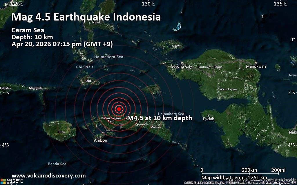 An earthquake of magnitude 4.5 occurred early evening on Monday, April 20th, 2026, at 7:15 pm local time near Amahai, Kabupaten Maluku Tengah, Maluku, Indonesia, as reported by Indonesia's Meteorology, Climatology, and Geophysical Agency.
According to preliminary data, the quake was located at a shallow depth of 10. km. Shallow earthquakes are felt more strongly than deeper ones as they are closer to the surface. The exact magnitude, epicenter, and depth of the quake might be revised within the next few hours or minutes as seismologists review data and refine their calculations, or as other agencies issue their report.
A second report was later issued by the citizen-seismograph network of RaspberryShake, which listed it as a magnitude 4.5 earthquake as well.
Towns or cities near the epicenter where the quake might have been felt as very weak shaking include Masohi (pop. 36,400) located 75 km from the epicenter, and Amahai (pop. 47,700) 79 km away.
VolcanoDiscovery will automatically update magnitude and depth if these change and follow up if other significant news about the quake become available. If you’re in the area, please send us your experience through our reporting mechanism, either online or via our mobile app. This will help us provide more first-hand updates to anyone around the globe who wants to know more about this quake.
Earthquake data: Date & time: Apr 20, 2026 07:15 pm (GMT +9) local time (20 Apr 2026 10:15 GMT)Magnitude: 4.5 Depth: 10.00 km Epicenter latitude / longitude: 2.63°S / 128.88°E  (West Seram Regency, Maluku, Indonesia) Primary data source: BMKGhttps://www.volcanodiscovery.com/earthquake/news/300324/Moderate-magnitude-45-earthquake-79-km-north-of-Amahai-Indonesia.html
|
|


CMS The Best Conveyancing solicitors conveyancing quotes throughout the UK
For any webhosting enquiries please email webmaster@aus-city.com
|
|
Entire Thread
|
 Moderate magnitude 4.5 earthquake 79 km north of Amahai, Indonesia
|
Webmaster
|
Mon 20 Apr 2026 10:25:AM
|
|
Forums60
Topics770,137
Posts804,915
Members2,958
| |
Most Online17,963
Jan 15th, 2026
|
|
|
|
|
Copyright 1996 - 2026 by David Cottle. Designed by David Bate Jr. All Rights Reserved.
By using this forum, the user agrees not to transfer any data or technical information received under the agreement, to any other entity without the express approval of the AUS-CITY Forum Admins and/or authors of individual posts (Forum Admins and DoD/USSPACECOM for the analysis of satellite tracking data).
Two-line elements (TLE) and all other satellite data presented and distributed via this forum and e-mail lists of AUS-CITY are distributed with permission from DoD/USSTRATCOM.

Reprise Hosting

|

|


 - Click image for larger picture.")


