|
|
|
1 members (Webmaster),
1,599
guests, and
5
robots. |
|
Key:
Admin,
Global Mod,
Mod
|
|
S |
M |
T |
W |
T |
F |
S |
|
|
|
|
|
|
1
|
2
|
|
3
|
4
|
5
|
6
|
7
|
8
|
9
|
|
10
|
11
|
12
|
13
|
14
|
15
|
16
|
|
17
|
18
|
19
|
20
|
21
|
22
|
23
|
|
24
|
25
|
26
|
27
|
28
|
29
|
30
|
|
31
|
|
|
|
|
|
|
|
There are no members with birthdays on this day. |
|
|
Joined: Feb 2001
Posts: 381,904
Launch Director
|
OP

Launch Director
Joined: Feb 2001
Posts: 381,904 |
Volcano earthquake report for Wednesday, 6 May 2026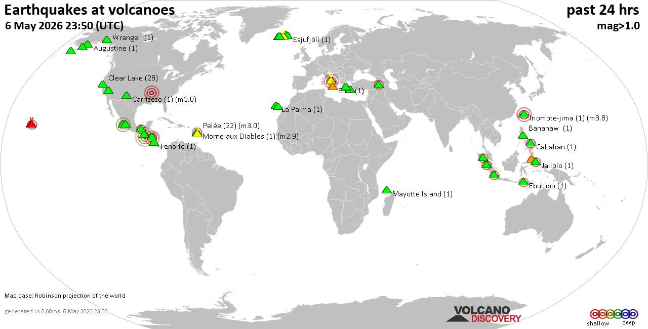 World map showing volcanoes with shallow (less than 50 km) earthquakes within 20 km radius during the past 24 hours on 6 May 2026 Number in brackets indicate nr of quakes. Quakes detected near: Agua (1 quake mag 4.2), Augustine (1 quake mag 1.3), Banahaw (1 quake mag 1.5), Cabalian (1 quake mag 2.4), Campi Flegrei (Phlegrean Fields) (13 quakes between mag 0.1-1.9), Carrizozo (1 quake mag 3.0)
Clear Lake (25 quakes between mag 0.2-1.8), Colima (1 quake mag 3.0), Coso (8 quakes between mag 0.5-2.9), Denison (1 quake mag 2.1), Ebulobo (1 quake mag 2.2), El Chichón (8 quakes between mag 2.5-2.7), Esjufjöll (1 quake mag 1.0), Etna (1 quake mag 1.4), Hulubelu (2 quakes between mag 2.0-2.4), Iriomote-jima (1 quake mag 3.8), Katla (12 quakes between mag 0.1-1.7), Kilauea (8 quakes between mag 1.6-2.7), Kupreanof (3 quakes between mag 2.0-2.1), La Palma (1 quake mag 1.3), Martin (1 quake mag 1.1), Mascota (1 quake mag 3.8), Maunaloa (1 quake mag 2.2), Mayotte Island (3 quakes between mag 1.1-1.5), Michoacán-Guanajuato (2 quakes between mag 3.3-3.6), Morne aux Diables (1 quake mag 2.9), Okataina (Tarawera) (1 quake mag 1.5), Pelée (22 quakes between mag 0.0-3.0), Sinabung (1 quake mag 2.1), Sousaki (1 quake mag 1.3), Süphan Dağ (2 quakes between mag 2.3-2.5), Talakmau (2 quakes between mag 2.1-2.1), Tandikat (1 quake mag 2.7), Tenerife (2 quakes between mag 1.0-1.0), Vesuvius (5 quakes between mag 0.1-1.6), Wrangell (1 quake mag 1.7) (updated 17h50)
Note: Earthquakes within 20 km from and at depths less than 50 km under active volcanoes are reported. The list is not complete because many volcanoes are not monitored and/or seismic data in high resolution is not available publicly.
Volcanoes with recent earthquakes above magnitude 2 or more than 10 quakes are listed below:
Agua volcano (Guatemala): magnitude 4.2 earthquakeA magnitude 4.2 earthquake occurred at the volcano 18 hours ago. The quake, which might be volcanic in origin, was located at a depth of 32.00 km depth at 7 km distance SSE from the volcano. Earthquake details: 4.2 quake North Pacific Ocean, Departamento de Guatemala, 58 km southeast of Puerto San Jose, Guatemala, May 5, 2026 05:58 pm (GMT -6) (7 km SSE) All earthquakes at AguaCabalian volcano (Central Philippines): magnitude 2.4 earthquakeA magnitude 2.4 earthquake occurred at the volcano 6 hours ago. The quake, which might be volcanic in origin, was located at a depth of 4.00 km depth at 13 km distance NW from the volcano. Earthquake details: 2.4 quake 44 km northeast of Maasin, Philippines, May 6, 2026 07:43 pm (GMT +8) (13 km NW) All earthquakes at CabalianCampi Flegrei (Phlegrean Fields) volcano (Italy): 13 earthquakes up to magnitude 1.9Possible earthquake swarm: 13 earthquakes occurred near (under) the volcano during 20 hours, the last being recorded quake 3 hours ago. Hypocenter depths ranged between 4.65 and 0.02 km. Earthquake details: (only 5 largest) 1.9 quake 2.3 km east of Pozzuoli, Napoli, Campania, Italy, May 6, 2026 01:26 am (GMT +2) (2 km NW) 1.5 quake Tyrrhenian Sea, 20 km northeast of Isola d'Ischia Island, Italy, May 6, 2026 04:32 pm (GMT +2) (3 km SSW) 1.0 quake Tyrrhenian Sea, 20 km northeast of Isola d'Ischia Island, Italy, May 6, 2026 04:33 pm (GMT +2) (4 km SSW) 0.6 quake 3.8 km east of Pozzuoli, Napoli, Campania, Italy, May 6, 2026 04:26 pm (GMT +2) (1 km N) 0.5 quake 13 km west of Naples, Napoli, Campania, Italy, May 6, 2026 02:52 am (GMT +2) (2 km W) All earthquakes at Campi Flegrei (Phlegrean Fields)Carrizozo volcano (New Mexico): magnitude 3.0 earthquakeA magnitude 3.0 earthquake occurred at the volcano 13 hours ago. The quake, which might be volcanic in origin, was located at a depth of 10.00 km depth at 1 km distance E from the volcano. Earthquake details: Reported seismic-like event (likely no quake): 21 mi northeast of Jacksonville, Pulaski County, Arkansas, United States, May 5, 2026 11:37 pm (GMT -5) (1 km E) All earthquakes at CarrizozoClear Lake volcano (California): 25 earthquakes up to magnitude 1.8Possible earthquake swarm: 25 earthquakes occurred near (under) the volcano during 23 hours, the last being recorded quake 25 minutes ago. Hypocenter depths ranged between 13.45 and 1.20 km. Earthquake details: (only 5 largest) 1.8 quake 13 mi southwest of Clearlake, Lake County, California, United States, May 6, 2026 03:56 am (GMT -7) (15 km S) 1.6 quake Sonoma County, 13 mi southwest of Clearlake, Lake County, California, United States, May 5, 2026 11:54 pm (GMT -7) (17 km S) 1.3 quake Lake County, 28 mi north of Santa Rosa, Sonoma County, California, United States, May 6, 2026 08:56 am (GMT -7) (15 km S) 1.2 quake Mendocino County, 23 mi north of Windsor, Sonoma County, California, United States, May 5, 2026 09:30 pm (GMT -7) (16 km SW) 1.1 quake Lake County, 28 mi north of Santa Rosa, Sonoma County, California, United States, May 5, 2026 12:59 pm (GMT -7) (15 km S) All earthquakes at Clear LakeColima volcano (Western & Central Mexico): magnitude 3.0 earthquakeA magnitude 3.0 earthquake occurred at the volcano 10 hours ago. The quake, which might be volcanic in origin, was located at a depth of 30.30 km depth at 13 km distance WSW from the volcano. Earthquake details: 3.0 quake Estado de Jalisco, 23 km north of Ciudad de Villa de Alvarez, Mexico, May 6, 2026 02:05 am (GMT -6) (13 km WSW) All earthquakes at ColimaCoso volcano (California): 8 earthquakes up to magnitude 2.98 earthquakes occurred near (under) the volcano during 21 hours, the last being recorded quake 43 minutes ago. Hypocenter depths ranged between 7.75 and 1.05 km. Earthquake details: (only 5 largest) 2.9 quake Inyo County, 28 mi north of Ridgecrest, Kern County, California, United States, May 5, 2026 01:14 pm (GMT -7) (3 km SE) 2.4 quake Inyo County, 28 mi north of Ridgecrest, Kern County, California, United States, May 5, 2026 01:12 pm (GMT -7) (3 km SE) 1.9 quake Inyo County, 28 mi north of Ridgecrest, Kern County, California, United States, May 5, 2026 07:28 pm (GMT -7) (3 km SE) 1.1 quake Inyo County, 19 mi north of Ridgecrest, Kern County, California, United States, May 6, 2026 10:06 am (GMT -7) (19 km SSE) 1.1 quake Inyo County, 28 mi north of Ridgecrest, Kern County, California, United States, May 5, 2026 01:28 pm (GMT -7) (3 km SE) All earthquakes at CosoDenison volcano (Alaska Peninsula): magnitude 2.1 earthquakeA magnitude 2.1 earthquake occurred at the volcano 23 hours ago. The quake, which might be volcanic in origin, was located at a depth of 1.70 km depth at 10 km distance NW from the volcano. Earthquake details: 2.1 quake Lake and Peninsula Borough, 92 mi northwest of Kodiak, Kodiak Island Borough, Alaska, United States, May 5, 2026 10:51 am (GMT -8) (10 km NW) All earthquakes at DenisonEbulobo volcano (Flores): magnitude 2.2 earthquakeA magnitude 2.2 earthquake occurred at the volcano 17 hours ago. The quake, which might be volcanic in origin, was located at a depth of 23.00 km depth at 11 km distance NW from the volcano. Earthquake details: 2.2 quake Kabupaten Ngada, 62 km west of Ende, Indonesia, May 6, 2026 09:07 am (GMT +8) (11 km NW) All earthquakes at EbuloboEl Chichón volcano (Southern Mexico): 8 earthquakes up to magnitude 2.78 earthquakes occurred near (under) the volcano during 11 hours, the last being recorded quake 7 hours ago. Hypocenter depths ranged between 4.40 and 2.40 km. Earthquake details: (only 5 largest) 2.7 quake Estado de Chiapas, 44 km southwest of Teapa, Estado de Tabasco, Mexico, May 5, 2026 10:18 pm (GMT -6) (7 km SW) 2.7 quake Estado de Chiapas, 36 km southwest of Teapa, Estado de Tabasco, Mexico, May 5, 2026 09:19 pm (GMT -6) (2 km ESE) 2.7 quake Estado de Chiapas, 36 km southwest of Teapa, Estado de Tabasco, Mexico, May 6, 2026 04:21 am (GMT -6) (1 km NNW) 2.6 quake Estado de Chiapas, 37 km southwest of Teapa, Estado de Tabasco, Mexico, May 5, 2026 10:40 pm (GMT -6) (1 km NW) 2.5 quake Estado de Chiapas, 37 km southwest of Teapa, Estado de Tabasco, Mexico, May 5, 2026 05:10 pm (GMT -6) (0 km NW) All earthquakes at El ChichónHulubelu volcano (Sumatra): 2 earthquakes up to magnitude 2.42 earthquakes occurred near (under) the volcano during 10 hours, the last being recorded quake 6 hours ago. Hypocenter depths ranged between 38.00 and 25.00 km. Earthquake details: 2.4 quake Kabupaten Tanggamus, 80 km west of Bandar Lampung, Indonesia, May 6, 2026 09:19 am (GMT +7) (15 km SSW) 2.0 quake Kabupaten Tanggamus, 86 km west of Bandar Lampung, Indonesia, May 6, 2026 07:17 pm (GMT +7) (12 km WSW) All earthquakes at HulubeluIriomote-jima volcano (Ryukyu Islands): magnitude 3.8 earthquakeA magnitude 3.8 earthquake occurred at the volcano 16 hours ago. The quake, which might be volcanic in origin, was located at a depth of 10.00 km depth at 12 km distance WSW from the volcano. Earthquake details: 3.8 quake East China Sea, 20 km north of Iriomote Jima Island, Okinawa, Japan, May 6, 2026 10:43 am (GMT +9) (12 km WSW) All earthquakes at Iriomote-jimaKatla volcano (Iceland): 12 earthquakes up to magnitude 1.7Possible earthquake swarm: 12 earthquakes occurred near (under) the volcano during 5 hours, the last being recorded quake 11 hours ago. Hypocenter depths ranged between 18.50 and 0.00 km. Earthquake details: (only 5 largest) 1.7 quake 3.2 km NNW of Hábunga May 6, 2026 06:26 am (Universal Time) (5 km SW) 1.4 quake 7.8 km ENE of Goðabunga May 6, 2026 01:41 am (Universal Time) (3 km NW) 1.3 quake 4.4 km NW of Hábunga May 6, 2026 06:29 am (Universal Time) (6 km WSW) 1.1 quake 3.4 km NNW of Hábunga May 6, 2026 06:31 am (Universal Time) (5 km SW) 1.0 quake 2.5 km WNW of Hábunga May 6, 2026 06:30 am (Universal Time) (6 km SW) All earthquakes at KatlaKilauea volcano (Hawai'i (Big Island)): 8 earthquakes up to magnitude 2.78 earthquakes occurred near (under) the volcano during 21 hours, the last being recorded quake 1 hour 4 minutes ago. Hypocenter depths ranged between 44.47 and 0.26 km. Earthquake details: (only 5 largest) 2.7 quake 26 mi southwest of Hilo, Hawaii County, Hawaii, United States, May 5, 2026 09:20 pm (GMT -10) (1 km ESE) 2.2 quake 28 mi south of Hilo, Hawaii County, Hawaii, United States, May 5, 2026 09:00 pm (GMT -10) (18 km ESE) 2.2 quake 25 mi southwest of Hilo, Hawaii County, Hawaii, United States, May 5, 2026 04:24 pm (GMT -10) (2 km E) 2.0 quake 30 mi south of Hilo, Hawaii County, Hawaii, United States, May 6, 2026 06:46 am (GMT -10) (13 km SE) 1.9 quake 26 mi southwest of Hilo, Hawaii County, Hawaii, United States, May 5, 2026 10:01 am (GMT -10) (1 km SE) All earthquakes at KilaueaKupreanof volcano (Alaska Peninsula): 3 earthquakes up to magnitude 2.13 earthquakes occurred near (under) the volcano during 9 hours, the last being recorded quake 23 minutes ago. Hypocenter depths ranged between 11.80 and 0.30 km. Earthquake details: 2.1 quake 52 mi northeast of Sand Point, Aleutians East Borough, Alaska, United States, May 6, 2026 12:45 am (GMT -8) (6 km W) 2.0 quake Lake and Peninsula Borough, 50 mi northeast of Sand Point, Aleutians East Borough, Alaska, United States, May 6, 2026 09:26 am (GMT -8) (7 km S) 2.0 quake 54 mi northeast of Sand Point, Aleutians East Borough, Alaska, United States, May 6, 2026 05:26 am (GMT -8) (8 km WNW) All earthquakes at KupreanofMascota volcano (Western & Central Mexico): magnitude 3.8 earthquakeA magnitude 3.8 earthquake occurred at the volcano 22 hours ago. The quake, which might be volcanic in origin, was located at a depth of 27.20 km depth at 10 km distance WNW from the volcano. Earthquake details: 3.8 quake 32 km east of Puerto Vallarta, Estado de Jalisco, Mexico, May 5, 2026 01:31 pm (GMT -6) (10 km WNW) All earthquakes at MascotaMaunaloa volcano (Hawai'i (Big Island)): magnitude 2.2 earthquakeA magnitude 2.2 earthquake occurred at the volcano 16 hours ago. The quake, which might be volcanic in origin, was located at a depth of 8.61 km depth at 18 km distance SE from the volcano. Earthquake details: 2.2 quake 36 mi southwest of Hilo, Hawaii County, Hawaii, United States, May 5, 2026 04:03 pm (GMT -10) (18 km SE) All earthquakes at MaunaloaMichoacán-Guanajuato volcano (Western & Central Mexico): 2 earthquakes up to magnitude 3.62 earthquakes occurred near (under) the volcano during 1 hour 45 minutes, the last being recorded quake 8 hours ago. Hypocenter depths ranged between 9.20 and 8.30 km. Earthquake details: 3.6 quake 22 km west of Uruapan, Estado de Michoacan de Ocampo, Mexico, May 6, 2026 02:11 am (GMT -6) (4 km SSW) 3.3 quake 25 km west of Uruapan, Estado de Michoacan de Ocampo, Mexico, May 6, 2026 03:56 am (GMT -6) (9 km SW) All earthquakes at Michoacán-GuanajuatoMorne aux Diables volcano (Caribbean): magnitude 2.9 earthquakeA magnitude 2.9 earthquake occurred at the volcano 14 hours ago. The quake, which might be volcanic in origin, was located at a depth of 8.22 km depth at 13 km distance NW from the volcano. Earthquake details: 2.9 quake Caribbean Sea, 35 km northwest of Dominica Island, Dominica, May 6, 2026 12:19 am (GMT -4) (13 km NW) All earthquakes at Morne aux DiablesPelée volcano (Caribbean): 22 earthquakes up to magnitude 3.0Possible earthquake swarm: 22 earthquakes occurred near (under) the volcano during 11 hours, the last being recorded quake 6 hours ago. Hypocenter depths ranged between 10.00 and 0.09 km. Earthquake details: (only 5 largest) Reported seismic-like event (likely no quake): 28 km northwest of Fort-de-France, Martinique, May 5, 2026 08:50 pm (GMT -4) (6 km WSW) 1.3 quake 25 km northwest of Fort-de-France, Martinique, May 6, 2026 03:21 am (GMT -4) (1 km SSE) 1.2 quake 25 km northwest of Fort-de-France, Martinique, May 6, 2026 05:04 am (GMT -4) (1 km SSE) 1.2 quake 25 km northwest of Fort-de-France, Martinique, May 6, 2026 04:21 am (GMT -4) (1 km SSE) 1.0 quake 25 km northwest of Fort-de-France, Martinique, May 6, 2026 06:38 am (GMT -4) (1 km SSE) All earthquakes at PeléeSinabung volcano (Sumatra): magnitude 2.1 earthquakeA magnitude 2.1 earthquake occurred at the volcano 1 hour 3 minutes ago. The quake, which might be volcanic in origin, was located at a depth of 23.00 km depth at 10 km distance S from the volcano. Earthquake details: 2.1 quake 11 km west of Kabanjahe, Kabupaten Karo, North Sumatra, Indonesia, May 6, 2026 11:46 pm (GMT +7) (10 km S) All earthquakes at SinabungSüphan Dağ volcano (Turkey): 2 earthquakes up to magnitude 2.52 earthquakes occurred near (under) the volcano during 1 hour 50 minutes, the last being recorded quake 13 hours ago. Hypocenter depths ranged between 7.00 and 5.00 km. Earthquake details: 2.5 quake Bitlis, 26 km south of Patnos, Agri, Turkey, May 6, 2026 05:41 am (GMT +3) (7 km N) 2.3 quake Bitlis, 25 km south of Patnos, Agri, Turkey, May 6, 2026 07:31 am (GMT +3) (8 km N) All earthquakes at Süphan DağTalakmau volcano (Sumatra): 2 earthquakes up to magnitude 2.12 earthquakes occurred near (under) the volcano during 5 hours, the last being recorded quake 19 hours ago. Hypocenter depths ranged between 14.00 and 3.00 km. Earthquake details: 2.1 quake Kabupaten Pasaman Barat, 71 km northwest of Bukittinggi, Indonesia, May 6, 2026 06:18 am (GMT +7) (11 km NNW) 2.1 quake Kabupaten Pasaman Barat, 76 km northwest of Bukittinggi, Indonesia, May 6, 2026 01:36 am (GMT +7) (16 km NNW) All earthquakes at TalakmauTandikat volcano (Sumatra): magnitude 2.7 earthquakeA magnitude 2.7 earthquake occurred at the volcano 12 hours ago. The quake, which might be volcanic in origin, was located at a depth of 3.00 km depth at 10 km distance WSW from the volcano. Earthquake details: 2.7 quake Kabupaten Padang Pariaman, 20 km northeast of Pariaman, Indonesia, May 6, 2026 01:08 pm (GMT +7) (10 km WSW) All earthquakes at Tandikathttps://www.volcanodiscovery.com/earthquakes-volcanoes/news/301541/Volcano-earthquake-report-for-Wednesday-6-May-2026.html
|
|


CMS The Best Conveyancing solicitors conveyancing quotes throughout the UK
For any webhosting enquiries please email webmaster@aus-city.com
|
|
Entire Thread
|

 Volcano earthquake report for Wednesday, 6 May 2026
|
Webmaster
|
4 hours ago
|
|
Forums60
Topics771,950
Posts806,738
Members2,958
| |
Most Online17,963
Jan 15th, 2026
|
|
|
|
|
Copyright 1996 - 2026 by David Cottle. Designed by David Bate Jr. All Rights Reserved.
By using this forum, the user agrees not to transfer any data or technical information received under the agreement, to any other entity without the express approval of the AUS-CITY Forum Admins and/or authors of individual posts (Forum Admins and DoD/USSPACECOM for the analysis of satellite tracking data).
Two-line elements (TLE) and all other satellite data presented and distributed via this forum and e-mail lists of AUS-CITY are distributed with permission from DoD/USSTRATCOM.

Reprise Hosting

|

|


 - Click image for larger picture.")


