|
|
|
0 members (),
1,636
guests, and
25
robots. |
|
Key:
Admin,
Global Mod,
Mod
|
|
S |
M |
T |
W |
T |
F |
S |
|
|
1
|
2
|
3
|
4
|
5
|
6
|
|
7
|
8
|
9
|
10
|
11
|
12
|
13
|
|
14
|
15
|
16
|
17
|
18
|
19
|
20
|
|
21
|
22
|
23
|
24
|
25
|
26
|
27
|
|
28
|
29
|
30
|
|
|
|
|
|
There are no members with birthdays on this day. |

Volcano earthquake report for Friday, 26 Jun 2026
• Moderate mag. 4.7 earthquake - Indonesia: Northern Molucca Sea on Friday, J...
• World Earthquake Report for Friday, 26 June 2026
• Significant 5.0 quake hits near La Romana, Provincia de La Romana, Dominica...
• No Tsunami Threat After Magnitude 5.0 Earthquake Near Isla Mona
• Moderate mag. 4.9 earthquake - Caribbean Sea, Provincia de San Cristobal, 3...
|

#811356
Sun 17 May 2026 06:41:AM
|
Joined: Feb 2001
Posts: 678,976
Launch Director
|
OP

Launch Director
Joined: Feb 2001
Posts: 678,976 |
SPC Severe Thunderstorm Watch 212WW 212 SEVERE TSTM KS MO 170355Z - 171100Z 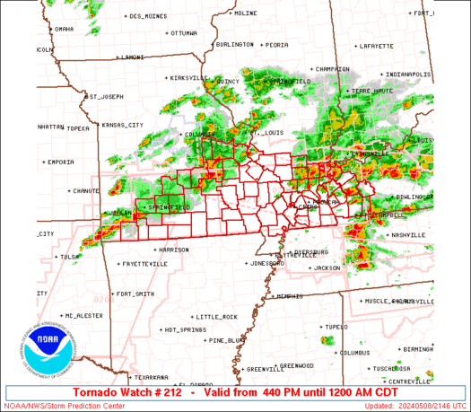
URGENT - IMMEDIATE BROADCAST REQUESTED
Severe Thunderstorm Watch Number 212
NWS Storm Prediction Center Norman OK
1055 PM CDT Sat May 16 2026

The NWS Storm Prediction Center has issued a

* Severe Thunderstorm Watch for portions of
  Far Northeast Kansas
  Northwest into Northern Missouri

* Effective this Saturday night and Sunday morning from 1055 PM
  until 600 AM CDT.

* Primary threats include...
  Scattered damaging wind gusts to 70 mph possible
  Isolated large hail events to 1 inch in diameter possible

SUMMARY...Scattered strong to severe thunderstorms capable of
isolated damaging gusts will be possible into the early overnight
across northern Missouri.  A band of severe thunderstorms is
forecast to move east into the Watch from the west and pose a risk
for scattered severe gusts during the overnight.

The severe thunderstorm watch area is approximately along and 40
statute miles north and south of a line from 30 miles west northwest
of Saint Joseph MO to 40 miles east northeast of Chillicothe MO. For
a complete depiction of the watch see the associated watch outline
update (WOUS64 KWNS WOU2).

PRECAUTIONARY/PREPAREDNESS ACTIONS...

REMEMBER...A Severe Thunderstorm Watch means conditions are
favorable for severe thunderstorms in and close to the watch area.
Persons in these areas should be on the lookout for threatening
weather conditions and listen for later statements and possible
warnings. Severe thunderstorms can and occasionally do produce
tornadoes.

&&

OTHER WATCH INFORMATION...CONTINUE...WW 210...WW 211...

AVIATION...A few severe thunderstorms with hail surface and aloft to
1 inch. Extreme turbulence and surface wind gusts to 60 knots. A few
cumulonimbi with maximum tops to 450. Mean storm motion vector
27035.

...Smith
Read morehttps://www.spc.noaa.gov/products/watch/ww0212.html
|
|


CMS The Best Conveyancing solicitors conveyancing quotes throughout the UK
For any webhosting enquiries please email webmaster@aus-city.com
|
|
Entire Thread
|
 SPC Severe Thunderstorm Watch 212
|
Webmaster
|
Sun 17 May 2026 06:41:AM
|
|
Forums60
Topics784,872
Posts819,639
Members2,960
| |
Most Online22,463
May 9th, 2026
|
|
|
|
|
Copyright 1996 - 2026 by David Cottle. Designed by David Bate Jr. All Rights Reserved.
By using this forum, the user agrees not to transfer any data or technical information received under this agreement to any other entity without the express approval of the AUS-CITY Forum Admins and/or authors of individual posts (Forum Admins and DoD/USSPACECOM for the analysis of satellite tracking data).
Two-line elements (TLE) and all other satellite data presented and distributed via this forum and AUS-CITY mailing lists are distributed with permission from DoD/USSTRATCOM.

|

|


 - Click image for larger picture.")


