|
|
|
0 members (),
9,860
guests, and
23
robots. |
|
Key:
Admin,
Global Mod,
Mod
|
|
S |
M |
T |
W |
T |
F |
S |
|
|
1
|
2
|
3
|
4
|
5
|
6
|
|
7
|
8
|
9
|
10
|
11
|
12
|
13
|
|
14
|
15
|
16
|
17
|
18
|
19
|
20
|
|
21
|
22
|
23
|
24
|
25
|
26
|
27
|
|
28
|
29
|
30
|
|
|
|
|
|
There are no members with birthdays on this day. |
|
|
|
|
|
|
|
|
|
|
|
|
|
|
SPC MD 952
by Webmaster - Tue 02 Jun 2026 04:15:AM
|
|
|
by Webmaster - Tue 02 Jun 2026 04:07:AM
|

Volcano earthquake report for Tuesday, 2 Jun 2026
• Moderate mag. 4.0 earthquake - Kabupaten Nabire, South Papua, Indonesia, on...
• Moderate mag. 4.9 earthquake - South Pacific Ocean, 166 km southeast of Nam...
• Moderate earthquake of magnitude 4.5 just reported 76 km northwest of Catud...
• Moderate mag. 4.8 earthquake - South China Sea, 88 km west of Santiago Isla...
• World Earthquake Report for Monday, 1 June 2026
|
|
|
Joined: Feb 2001
Posts: 381,904
Launch Director
|
OP

Launch Director
Joined: Feb 2001
Posts: 381,904 |
Volcano earthquake report for Monday, 1 Jun 2026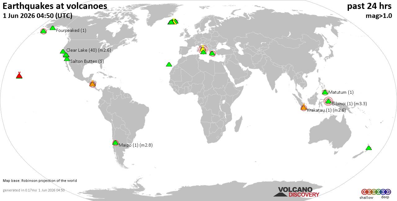 World map showing volcanoes with shallow (less than 50 km) earthquakes within 20 km radius during the past 24 hours on 1 Jun 2026 Number in brackets indicate nr of quakes. Quakes detected near: Babuyan Claro (1 quake mag 1.9), Bardarbunga (7 quakes between mag 0.5-3.7), Bratan (1 quake mag 2.8), Bulusan (1 quake mag 4.1), Campi Flegrei (Phlegrean Fields) (32 quakes between mag 0.1-1.5), Cerro Negro (1 quake mag 1.4)
Clear Lake (29 quakes between mag 0.2-1.8), Coso (4 quakes between mag 0.3-1.4), Eldey (9 quakes between mag 0.0-2.1), Heiðarsporðar (5 quakes between mag 0.0-1.7), Hengill (65 quakes between mag 0.0-3.8), Hofsjökull (1 quake mag 1.7), Hrómundartindur (406 quakes between mag 0.0-4.2), Hulubelu (7 quakes between mag 2.0-3.1), Katla (5 quakes between mag 0.1-2.0), Kilauea (6 quakes between mag 1.7-2.6), Maunaloa (2 quakes between mag 1.9-2.3), Mayotte Island (1 quake mag 1.3), Musuan (1 quake mag 3.0), Ngauruhoe (1 quake mag 2.3), Patoc (1 quake mag 1.8), Platanar (3 quakes between mag 1.9-2.2), Prestahnukur (16 quakes between mag 0.4-1.6), Ruapehu (1 quake mag 1.6), Santa Ana (1 quake mag 2.2), Santo Tomas (1 quake mag 1.5), Sousaki (1 quake mag 1.7), Süphan Dağ (1 quake mag 2.5), Tenerife (2 quakes between mag 1.0-1.1), Tjörnes Fracture Zone (7 quakes between mag 0.8-1.2), Toroeng Prong (1 quake mag 3.7), Ubehebe Craters (1 quake mag 2.2), Vatnafjöll (1 quake mag 1.6), Wide Bay (2 quakes between mag 1.5-2.8) (updated 23h50)
Note: Earthquakes within 20 km from and at depths less than 50 km under active volcanoes are reported. The list is not complete because many volcanoes are not monitored and/or seismic data in high resolution is not available publicly.
Volcanoes with recent earthquakes above magnitude 2 or more than 10 quakes are listed below:
Bardarbunga volcano (Iceland): 7 earthquakes up to magnitude 3.77 earthquakes occurred near (under) the volcano during 19 hours, the last being recorded quake 5 hours ago. Hypocenter depths ranged between 5.20 and 0.40 km. Earthquake details: (only 5 largest) 3.7 quake Northeast, 225 km east of Reykjavik, Capital Region, Iceland, Jun 1, 2026 02:12 pm (Reykjavik time) (8 km E) 1.1 quake 3.1 km SSE of Bárðarbunga Jun 1, 2026 12:26 am (Universal Time) (2 km SSE) 0.8 quake Iceland: 1.1 km SSE of Bárðarbunga Jun 1, 2026 09:12 am (Reykjavik time) (1 km ENE) 0.6 quake Iceland: 6.0 km ESE of Bárðarbunga Jun 1, 2026 07:09 pm (Reykjavik time) (6 km E) 0.6 quake 8.5 km E of Bárðarbunga Jun 1, 2026 08:40 am (Universal Time) (8 km E) All earthquakes at BardarbungaBratan volcano (Bali): magnitude 2.8 earthquakeA magnitude 2.8 earthquake occurred at the volcano 9 hours ago. The quake, which might be volcanic in origin, was located at a depth of 30.00 km depth at 19 km distance W from the volcano. Earthquake details: 2.8 quake 13 km south of Banjar, Kabupaten Buleleng, Provinsi Bali, Indonesia, Jun 1, 2026 11:02 pm (GMT +8) (19 km W) All earthquakes at BratanBulusan volcano (Luzon Island): magnitude 4.1 earthquakeA magnitude 4.1 earthquake occurred at the volcano 10 hours ago. The quake, which might be volcanic in origin, was located at a depth of 10.00 km depth at 8 km distance SSW from the volcano. Earthquake details: 4.1 quake Philippine Sea, 24 km east of Masbate Island, Philippines, Jun 1, 2026 09:27 pm (Manila time) (8 km SSW) All earthquakes at BulusanCampi Flegrei (Phlegrean Fields) volcano (Italy): 32 earthquakes up to magnitude 1.5Possible earthquake swarm: 32 earthquakes occurred near (under) the volcano during 22 hours, the last being recorded quake 15 minutes ago. Hypocenter depths ranged between 4.51 and 0.09 km. Earthquake details: (only 5 largest) 1.5 quake 4.5 km west of Fuorigrotta, Napoli, Campania, Italy, Jun 2, 2026 12:06 am (GMT +2) (1 km SE) 0.8 quake 1.7 km northwest of Bagnoli, Napoli, Campania, Italy, Jun 1, 2026 08:50 pm (Universal Time) (1 km ESE) 0.8 quake 2 km southwest of Pozzuoli, Napoli, Campania, Italy, Jun 1, 2026 10:55 am (Universal Time) (4 km W) 0.8 quake 4.2 km southeast of Pozzuoli, Napoli, Campania, Italy, Jun 1, 2026 10:31 pm (Universal Time) (1 km SSW) 0.7 quake 4.4 km west of Fuorigrotta, Napoli, Campania, Italy, Jun 1, 2026 11:34 pm (Universal Time) (1 km ESE) All earthquakes at Campi Flegrei (Phlegrean Fields)Clear Lake volcano (California): 29 earthquakes up to magnitude 1.8Possible earthquake swarm: 29 earthquakes occurred near (under) the volcano during 22 hours, the last being recorded quake 39 minutes ago. Hypocenter depths ranged between 16.43 and 0.14 km. Earthquake details: (only 5 largest) 1.8 quake Sonoma County, 15 mi southwest of Clearlake, Lake County, California, United States, Jun 1, 2026 04:23 am (GMT -7) (19 km SSW) 1.8 quake Sonoma County, 14 mi southwest of Clearlake, Lake County, California, United States, May 31, 2026 11:17 pm (GMT -7) (16 km SSW) 1.5 quake Sonoma County, 13 mi southwest of Clearlake, Lake County, California, United States, Jun 1, 2026 12:57 am (GMT -7) (16 km SSW) 1.5 quake 26 mi north of Santa Rosa, Sonoma County, California, United States, Jun 1, 2026 02:50 pm (GMT -7) (19 km SSW) 1.3 quake 26 mi north of Santa Rosa, Sonoma County, California, United States, Jun 1, 2026 09:18 am (GMT -7) (18 km SSW) All earthquakes at Clear LakeEldey volcano (Iceland): 9 earthquakes up to magnitude 2.19 earthquakes occurred near (under) the volcano during 23 hours, the last being recorded quake 27 minutes ago. Hypocenter depths ranged between 12.60 and 2.20 km. Earthquake details: (only 5 largest) 2.1 quake 10.3 km N of Eldey Jun 1, 2026 09:06 pm (Universal Time) (11 km N) 2.0 quake Iceland: 9.7 km N of Eldey Jun 1, 2026 11:06 pm (Reykjavik time) (10 km N) 1.8 quake Iceland: 4.3 km NNW of Eldeyjardrangur Jun 1, 2026 04:04 pm (Reykjavik time) (4 km NNW) 1.4 quake 8.7 km NNW of Eldey Jun 1, 2026 11:09 pm (Universal Time) (9 km N) 1.0 quake Iceland: 9.1 km WNW of Reykjanestá Jun 1, 2026 10:54 pm (Reykjavik time) (12 km NNE) All earthquakes at EldeyEldey is located at the beginning of the Reykjanes Ridge off the SW tip of Iceland. Its highest elevation is the top of Eldey Island, but most of the volcanic edifice is submerged. Several eruptions occurred in historic times, last in 1926. Hengill volcano (Iceland): 65 earthquakes up to magnitude 3.8Possible earthquake swarm: 65 earthquakes occurred near (under) the volcano during 23 hours, the last being recorded quake 18 minutes ago. Hypocenter depths ranged between 19.10 and 0.00 km. Earthquake details: (only 5 largest) 3.8 quake 23 km southeast of Reykjavik, Capital Region, Iceland, Jun 1, 2026 04:17 pm (Reykjavik time) (13 km SSW) 2.6 quake Iceland: 4.2 km ESE of Seljadalur Jun 1, 2026 04:45 pm (Reykjavik time) (12 km SW) 1.4 quake 1.8 km ENE of Eiturhóll Jun 1, 2026 05:05 pm (Universal Time) (6 km SSW) 1.2 quake Iceland: 5.5 km W of Seljadalur Jun 1, 2026 01:48 pm (Reykjavik time) (18 km WSW) 1.2 quake Iceland: 9.2 km NE of Geldinganes Jun 1, 2026 04:02 pm (Reykjavik time) (15 km WNW) All earthquakes at HengillHrómundartindur volcano (Iceland): 406 earthquakes up to magnitude 4.2Possible earthquake swarm: 406 earthquakes occurred near (under) the volcano during 24 hours, the last being recorded quake 15 minutes ago. Hypocenter depths ranged between 25.30 and 0.00 km. Earthquake details: (only 5 largest) 4.2 quake South, 36 km east of Reykjavik, Capital Region, Iceland, Jun 1, 2026 01:45 pm (Reykjavik time) (13 km N) 3.4 quake 23 km southeast of Reykjavik, Capital Region, Iceland, Jun 1, 2026 04:46 pm (Reykjavik time) (13 km WSW) 2.3 quake 2.4 km W of Hellisheiðarvirkjun Jun 1, 2026 04:27 pm (Universal Time) (12 km WSW) 2.2 quake Iceland: 2.6 km E of Litla_Kaffistofan Jun 1, 2026 03:09 pm (Reykjavik time) (12 km W) 2.0 quake 1.6 km ESE of Litla_Kaffistofan Jun 1, 2026 03:09 pm (Universal Time) (13 km W) All earthquakes at HrómundartindurHulubelu volcano (Sumatra): 7 earthquakes up to magnitude 3.17 earthquakes occurred near (under) the volcano during 3 hours, the last being recorded quake 10 hours ago. Hypocenter depths ranged between 14.00 and 4.00 km. Earthquake details: (only 5 largest) 3.1 quake Kabupaten Tanggamus, 79 km west of Bandar Lampung, Indonesia, Jun 1, 2026 05:32 pm (GMT +7) (3 km WSW) 2.5 quake Kabupaten Tanggamus, 79 km west of Bandar Lampung, Indonesia, Jun 1, 2026 05:34 pm (GMT +7) (2 km W) 2.4 quake Kabupaten Tanggamus, 77 km west of Bandar Lampung, Indonesia, Jun 1, 2026 05:37 pm (GMT +7) (1 km WNW) 2.1 quake Kabupaten Tanggamus, 75 km west of Bandar Lampung, Indonesia, Jun 1, 2026 08:47 pm (GMT +7) (2 km NE) 2.1 quake Kabupaten Tanggamus, 75 km west of Bandar Lampung, Indonesia, Jun 1, 2026 05:59 pm (GMT +7) (1 km SE) All earthquakes at HulubeluKilauea volcano (Hawai'i (Big Island)): 6 earthquakes up to magnitude 2.66 earthquakes occurred near (under) the volcano during 9 hours, the last being recorded quake 47 minutes ago. Hypocenter depths ranged between 31.92 and 0.10 km. Earthquake details: (only 5 largest) 2.6 quake 26 mi southwest of Hilo, Hawaii County, Hawaii, United States, Jun 1, 2026 12:38 pm (GMT -10) (2 km ESE) 2.1 quake 26 mi southwest of Hilo, Hawaii County, Hawaii, United States, Jun 1, 2026 01:03 pm (GMT -10) (2 km SE) 2.1 quake 26 mi southwest of Hilo, Hawaii County, Hawaii, United States, Jun 1, 2026 12:44 pm (GMT -10) (2 km ESE) 2.1 quake 26 mi southwest of Hilo, Hawaii County, Hawaii, United States, Jun 1, 2026 12:16 pm (GMT -10) (2 km ESE) 2.0 quake 26 mi southwest of Hilo, Hawaii County, Hawaii, United States, Jun 1, 2026 12:52 pm (GMT -10) (0 km SSW) All earthquakes at KilaueaMaunaloa volcano (Hawai'i (Big Island)): 2 earthquakes up to magnitude 2.32 earthquakes occurred near (under) the volcano during 22 minutes, the last being recorded quake 18 hours ago. Hypocenter depths ranged between 46.26 and 33.12 km. Earthquake details: 2.3 quake 39 mi southwest of Hilo, Hawaii County, Hawaii, United States, May 31, 2026 07:08 pm (GMT -10) (8 km SSE) 1.9 quake 39 mi southwest of Hilo, Hawaii County, Hawaii, United States, May 31, 2026 07:30 pm (GMT -10) (3 km SSW) All earthquakes at MaunaloaMusuan volcano (Mindanao): magnitude 3.0 earthquakeA magnitude 3.0 earthquake occurred at the volcano 18 hours ago. The quake, which might be volcanic in origin, was located at a depth of 10.00 km depth at 12 km distance SSW from the volcano. Earthquake details: Reported seismic-like event (likely no quake): 17 km southwest of NIA Valencia, Philippines, Jun 1, 2026 01:46 pm (GMT +8) (12 km SSW) All earthquakes at MusuanNgauruhoe volcano (North Island): magnitude 2.3 earthquakeA magnitude 2.3 earthquake occurred at the volcano 41 minutes ago. The quake, which might be volcanic in origin, was located at a depth of 36.20 km depth at 8 km distance SE from the volcano. Earthquake details: 2.3 quake 24 km southwest of Turangi, Waikato, New Zealand, Jun 2, 2026 11:08 am (GMT +12) (8 km SE) All earthquakes at NgauruhoePlatanar volcano (Costa Rica): 3 earthquakes up to magnitude 2.23 earthquakes occurred near (under) the volcano during 9 minutes, the last being recorded quake 22 hours ago. Hypocenter depths ranged between 2.00 and 0.00 km. Earthquake details: 2.2 quake 13 km southeast of Quesada, Provincia de Alajuela, Costa Rica, May 31, 2026 07:56 pm (Costa_Rica time) (6 km SSE) 1.9 quake 13 km southeast of Quesada, Provincia de Alajuela, Costa Rica, May 31, 2026 07:57 pm (Costa_Rica time) (6 km SSE) 1.9 quake 13 km southeast of Quesada, Provincia de Alajuela, Costa Rica, May 31, 2026 08:05 pm (Costa_Rica time) (6 km SSE) All earthquakes at PlatanarPrestahnukur volcano (Iceland): 16 earthquakes up to magnitude 1.6Possible earthquake swarm: 16 earthquakes occurred near (under) the volcano during 17 hours, the last being recorded quake 3 hours ago. Hypocenter depths ranged between 16.30 and 0.20 km. Earthquake details: (only 5 largest) 1.6 quake Iceland: 14.9 km SSE of Húsafell Jun 1, 2026 09:00 pm (Reykjavik time) (9 km WSW) 1.6 quake Iceland: 14.9 km SSE of Húsafell Jun 1, 2026 08:45 pm (Reykjavik time) (9 km WSW) 1.5 quake 14.6 km SSE of Húsafell Jun 1, 2026 07:12 am (Universal Time) (10 km WSW) 1.3 quake Iceland: 14.0 km SSE of Húsafell Jun 1, 2026 07:31 pm (Reykjavik time) (10 km WSW) 1.3 quake 15.1 km SSE of Húsafell Jun 1, 2026 06:58 am (Universal Time) (10 km WSW) All earthquakes at PrestahnukurSanta Ana volcano (El Salvador): magnitude 2.2 earthquakeA magnitude 2.2 earthquake occurred at the volcano 12 hours ago. The quake, which might be volcanic in origin, was located at a depth of 6.00 km depth at 7 km distance W from the volcano. Earthquake details: 2.2 quake 15 km north of Sonsonate, Departamento de Sonsonate, El Salvador, Jun 1, 2026 06:08 am (GMT -6) (7 km W) All earthquakes at Santa AnaSüphan Dağ volcano (Turkey): magnitude 2.5 earthquakeA magnitude 2.5 earthquake occurred at the volcano 18 hours ago. The quake, which might be volcanic in origin, was located at a depth of 8.80 km depth at 8 km distance N from the volcano. Earthquake details: 2.5 quake Bitlis, 25 km south of Patnos, Agri, Turkey, Jun 1, 2026 08:35 am (GMT +3) (8 km N) All earthquakes at Süphan DağToroeng Prong volcano (Vietnam): magnitude 3.7 earthquakeA magnitude 3.7 earthquake occurred at the volcano 1 hour 42 minutes ago. The quake, which might be volcanic in origin, was located at a depth of 10.00 km depth at 18 km distance NW from the volcano. Earthquake details: 3.7 quake 66 km north of Kon Tum, Kon Tum, Vietnam, Jun 2, 2026 05:08 am (Ho Chi Minh time) (18 km NW) All earthquakes at Toroeng ProngUbehebe Craters volcano (California): magnitude 2.2 earthquakeA magnitude 2.2 earthquake occurred at the volcano 14 minutes ago. The quake, which might be volcanic in origin, was located at a depth of 2.15 km depth at 15 km distance NNE from the volcano. Earthquake details: 2.2 quake Esmeralda County, Nevada, 120 mi northeast of Visalia, Tulare County, California, United States, Jun 1, 2026 04:35 pm (GMT -7) (15 km NNE) All earthquakes at Ubehebe CratersWide Bay volcano (Aleutian Islands): 2 earthquakes up to magnitude 2.82 earthquakes occurred near (under) the volcano during 1 hour 35 minutes, the last being recorded quake 14 hours ago. Hypocenter depths ranged between 9.30 and 7.30 km. Earthquake details: 2.8 quake 4 mi west of Dutch Harbor, Aleutians West Census Area, Alaska, United States, Jun 1, 2026 01:21 am (GMT -8) (8 km S) 1.5 quake 3.7 mi west of Dutch Harbor, Aleutians West Census Area, Alaska, United States, May 31, 2026 11:47 pm (GMT -8) (8 km S) All earthquakes at Wide Bayhttps://www.volcanodiscovery.com/earthquakes-volcanoes/news/303849/Volcano-earthquake-report-for-Monday-1-Jun-2026.html
|
|


CMS The Best Conveyancing solicitors conveyancing quotes throughout the UK
For any webhosting enquiries please email webmaster@aus-city.com
|
|
Entire Thread
|

 Volcano earthquake report for Monday, 1 Jun 2026
|
Webmaster
|
Yesterday at 11:50 PM
|
|
Forums60
Topics778,025
Posts812,831
Members2,960
| |
Most Online22,463
May 9th, 2026
|
|
|
|
|
Copyright 1996 - 2026 by David Cottle. Designed by David Bate Jr. All Rights Reserved.
By using this forum, the user agrees not to transfer any data or technical information received under this agreement to any other entity without the express approval of the AUS-CITY Forum Admins and/or authors of individual posts (Forum Admins and DoD/USSPACECOM for the analysis of satellite tracking data).
Two-line elements (TLE) and all other satellite data presented and distributed via this forum and AUS-CITY mailing lists are distributed with permission from DoD/USSTRATCOM.

|

|


 - Click image for larger picture.")


