|
|
|
0 members (),
1,362
guests, and
31
robots. |
|
Key:
Admin,
Global Mod,
Mod
|
|
S |
M |
T |
W |
T |
F |
S |
|
|
|
|
1
|
2
|
3
|
4
|
|
5
|
6
|
7
|
8
|
9
|
10
|
11
|
|
12
|
13
|
14
|
15
|
16
|
17
|
18
|
|
19
|
20
|
21
|
22
|
23
|
24
|
25
|
|
26
|
27
|
28
|
29
|
30
|
31
|
|
|
There are no members with birthdays on this day. |

Significant magnitude 5.2 earthquake 58 km north of Valparaiso, Chile
• Small earthquake of magnitude 3.7 just reported 10 km southwest of Glogow, ...
• World Earthquake Report for Monday, 6 July 2026
• Significant 5.3 quake hits near Valparaiso, Provincia de Valparaíso, Regio...
• Moderate mag. 4.6 earthquake - South Pacific Ocean, 45 km north of Valparai...
• Strong mag. 5.2 earthquake - South Pacific Ocean, 58 km north of Valparaiso...
|

#818837
Tue 16 Jun 2026 03:34:AM
|
Joined: Feb 2001
Posts: 678,976
Launch Director
|
OP

Launch Director
Joined: Feb 2001
Posts: 678,976 |
Magnitude 6.8 earthquake strikes near Palu, Kota Palu, Sulawesi Tengah, Indonesia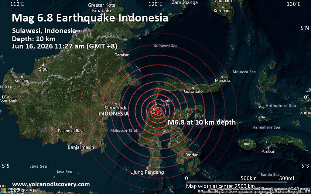 A magnitude 6.8 earthquake near Palu, Kota Palu, Sulawesi Tengah, Indonesia, was reported only 5 minutes ago by Indonesia's Meteorology, Climatology, and Geophysical Agency, considered the main national agency that monitors seismic activity in Indonesia. The earthquake occurred at a shallow depth of 10. km beneath the epicenter in the morning on Tuesday, June 16th, 2026, at 11:27 am local time. The exact magnitude, epicenter, and depth of the quake might be revised within the next few hours or minutes as seismologists review data and refine their calculations, or as other agencies issue their report.
Based on the preliminary seismic data, the quake should have been felt by everybody in the area of the epicenter. In those areas, dangerous ground shaking occurred with the potential to inflict moderate to heavy damage to buildings and other infrastructure.
Towns or cities where the quake likely caused strong ground shaking include
Moderate shaking probably occurred in Poso (pop. 47,500) located 74 km from the epicenter.
In Masamba (pop. 38,000) located 168 km from the epicenter, the quake should have been felt as light shaking.
VolcanoDiscovery will automatically update magnitude and depth if these change and follow up if other significant news about the quake become available. If you’re in the area, please send us your experience through our reporting mechanism, either online or via our mobile app. This will help us provide more first-hand updates to anyone around the globe who wants to know more about this quake.
Earthquake data: Date & time: Jun 16, 2026 03:27 am (Universal Time) local time (16 Jun 2026 03:27 GMT)Magnitude: 6.4 Depth: 45.00 km Epicenter latitude / longitude: 1.08°S / 120.27°E  ( Kabupaten Parigi Moutong, Sulawesi Tengah, Indonesia) Primary data source: EMSChttps://www.volcanodiscovery.com/earthquake/news/307189/Magnitude-68-earthquake-strikes-near-Palu-Kota-Palu-Sulawesi-Tengah-Indonesia.html
|
|


CMS The Best Conveyancing solicitors conveyancing quotes throughout the UK
For any webhosting enquiries please email webmaster@aus-city.com
|
|
Entire Thread
|
 Magnitude 6.8 earthquake strikes near Palu, Kota Palu, Sulawesi Tengah, Indonesia
|
Webmaster
|
Tue 16 Jun 2026 03:34:AM
|
|
Forums60
Topics787,155
Posts821,929
Members2,960
| |
Most Online22,463
May 9th, 2026
|
|
|
|
|
Copyright 1996 - 2026 by David Cottle. Designed by David Bate Jr. All Rights Reserved.
By using this forum, the user agrees not to transfer any data or technical information received under this agreement to any other entity without the express approval of the AUS-CITY Forum Admins and/or authors of individual posts (Forum Admins and DoD/USSPACECOM for the analysis of satellite tracking data).
Two-line elements (TLE) and all other satellite data presented and distributed via this forum and AUS-CITY mailing lists are distributed with permission from DoD/USSTRATCOM.

|

|


 - Click image for larger picture.")


