|
|
|
0 members (),
1,293
guests, and
37
robots. |
|
Key:
Admin,
Global Mod,
Mod
|
|
S |
M |
T |
W |
T |
F |
S |
|
|
1
|
2
|
3
|
4
|
5
|
6
|
|
7
|
8
|
9
|
10
|
11
|
12
|
13
|
|
14
|
15
|
16
|
17
|
18
|
19
|
20
|
|
21
|
22
|
23
|
24
|
25
|
26
|
27
|
|
28
|
29
|
30
|
|
|
|
|
|
There are no members with birthdays on this day. |

World Earthquake Report for Monday, 22 June 2026
• Moderate mag. 4.9 earthquake - Fiji Islands Region on Monday, Jun 22, 2026,...
• Moderate mag. 4.1 earthquake - South Pacific Ocean, 491 km northeast of Tau...
• Volcano earthquake report for Monday, 22 Jun 2026
• Moderate mag. 4.6 earthquake - 42 km south of Tocopilla, Provincia de Tocop...
• Moderate mag. 4.9 earthquake - South Pacific Ocean, 277 km south of Nuku'al...
|
|
|
Joined: Feb 2001
Posts: 678,976
Launch Director
|
OP

Launch Director
Joined: Feb 2001
Posts: 678,976 |
Small magnitude 3.6 earthquake 1 miles west of Pāhala, Hawaii, United States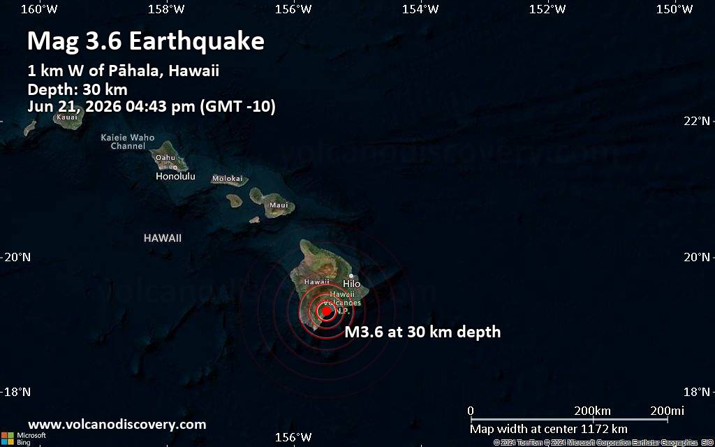 A magnitude 3.6 earthquake near Pāhala, Hawaii County, Hawaii, USA, was reported only 4 minutes ago by the United States Geological Survey, considered the key international and national agency that monitors seismic activity in the US. The earthquake occurred at a shallow depth of 18 miles beneath the epicenter in the afternoon on Sunday, June 21st, 2026, at 4:43 pm local time. The exact magnitude, epicenter, and depth of the quake might be revised within the next few hours or minutes as seismologists review data and refine their calculations, or as other agencies issue their report.
A second report was later issued by the European-Mediterranean Seismological Centre (EMSC), which listed it as a magnitude 2.8 earthquake.
Towns or cities near the epicenter where the quake might have been felt as very weak shaking include Pāhala (pop. 1,400) located 1 miles from the epicenter, Discovery Harbor (pop. 1,200) 14 miles away, Hawaiian Ocean View (pop. 4,400) 20 miles away, Volcano (pop. 2,600) 24 miles away, and Honaunau-Napoopoo (pop. 2,600) 30 miles away. In Mountain View (pop. 3,900, 35 miles away), Holualoa (pop. 8,500, 41 miles away), Hawaiian Paradise Park (pop. 11,400, 43 miles away), and Hilo (pop. 43,300, 45 miles away), the quake was probably not felt.
Earthquake data: Date & time: Jun 21, 2026 04:43 pm (GMT -10) local time (22 Jun 2026 02:43 GMT)Magnitude: 3.6 Depth: 29.69 km Epicenter latitude / longitude: 19.2°N / 155.49°W  ( Hawaii County, Hawaii, United States) Primary data source: USGShttps://www.volcanodiscovery.com/earthquake/news/317403/Small-magnitude-36-earthquake-1-miles-west-of-Pahala-Hawaii-United-States.html
|
|


CMS The Best Conveyancing solicitors conveyancing quotes throughout the UK
For any webhosting enquiries please email webmaster@aus-city.com
|
|
Entire Thread
|

 Small magnitude 3.6 earthquake 1 miles west of Pāhala, Hawaii, United States
|
Webmaster
|
Yesterday at 02:49 AM
|
|
Forums60
Topics783,548
Posts818,310
Members2,960
| |
Most Online22,463
May 9th, 2026
|
|
|
|
|
Copyright 1996 - 2026 by David Cottle. Designed by David Bate Jr. All Rights Reserved.
By using this forum, the user agrees not to transfer any data or technical information received under this agreement to any other entity without the express approval of the AUS-CITY Forum Admins and/or authors of individual posts (Forum Admins and DoD/USSPACECOM for the analysis of satellite tracking data).
Two-line elements (TLE) and all other satellite data presented and distributed via this forum and AUS-CITY mailing lists are distributed with permission from DoD/USSTRATCOM.

|

|


 - Click image for larger picture.")


