|
0 members (),
1,877
guests, and
21
robots. |
|
Key:
Admin,
Global Mod,
Mod
|
|
S |
M |
T |
W |
T |
F |
S |
|
|
|
|
1
|
2
|
3
|
4
|
|
5
|
6
|
7
|
8
|
9
|
10
|
11
|
|
12
|
13
|
14
|
15
|
16
|
17
|
18
|
|
19
|
20
|
21
|
22
|
23
|
24
|
25
|
|
26
|
27
|
28
|
29
|
30
|
31
|
|
|
There are no members with birthdays on this day. |
|
|
|
|
|
|
|
|
|
|
|
|
|
|
|
|
|
|
|
|
|
|
by Webmaster - Sun 26 Jul 2026 08:45:PM
|
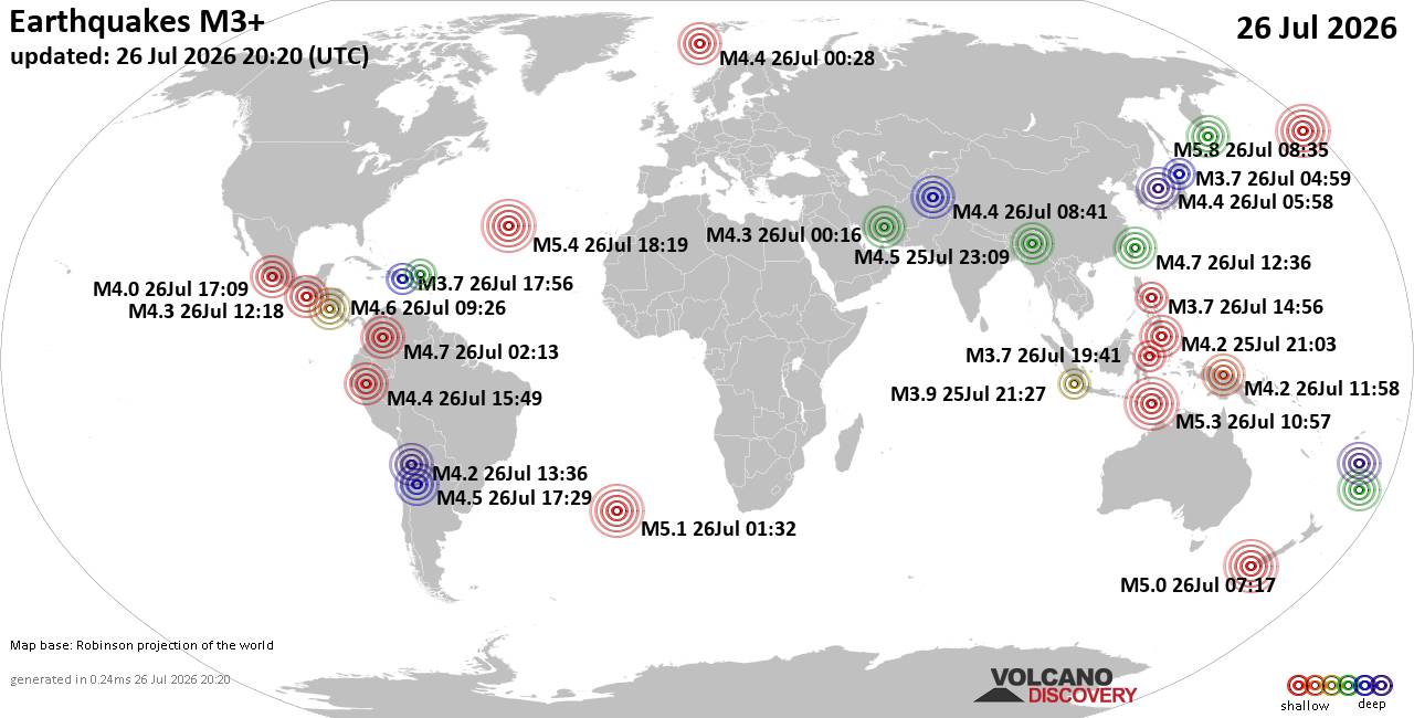
World Earthquake Report for Sunday, 26 July 2026
• Moderate mag. 4.5 earthquake - Estado de Veracruz-Llave, Mexico, on 2026-07...
• Volcano earthquake report for Sunday, 26 Jul 2026
• Moderate mag. 4.0 earthquake - Kabupaten Kepulauan Talaud, 148 km northeast...
• Light mag. 3.9 earthquake - North Pacific Ocean, 65 km south of Puerto San ...
• Strong mag. 5.4 earthquake - Northern Mid-Atlantic Ridge on Sunday, Jul 26,...
|
|
|
Joined: Feb 2001
Posts: 678,976
Launch Director
|
OP

Launch Director
Joined: Feb 2001
Posts: 678,976 |
SPC Jul 27, 2026 0730 UTC Day 3 Severe Thunderstorm OutlookSPC 0730Z Day 3 Outlook 
Day 3 Convective Outlook
NWS Storm Prediction Center Norman OK
0200 AM CDT Mon Jul 27 2026

Valid 291200Z - 301200Z

...THERE IS A MARGINAL RISK OF SEVERE THUNDERSTORMS IN THE SOUTHEAST
AND NORTHERN AND CENTRAL HIGH PLAINS...

...SUMMARY...
Isolated severe storms capable of mainly damaging winds appear
possible in the Southeast and northern and central High Plains
Wednesday afternoon into evening.

...Synopsis...

A short-wave trough will move through the Canadian Prairie
Provinces, effectively flattening the northern extension of the
upper ridge in those areas. There is some model signal for a
lower-latitude disturbance to progress from the northern Rockies
into the northern High Plains. Elsewhere, an upper low over the
Mid-Atlantic will evolve into an open wave with the broader-scale
trough slowly shifting east. At the surface, a cool front will
settle south through the Southeast, while a lee trough deepens over
the northern High Plains.


...Southeast...

A hot and very moist air mass is expected ahead of the front, with
moderate to strong instability developing by afternoon. The models
suggest the stronger mid-level winds and resultant vertical shear
will be displaced to the north of the frontal zone, which should
limit the organizational potential of the storms developing along
the boundary. Nonetheless, the degree of instability and high
precipitable water content will favor locally intense wet
microbursts capable of damaging winds, especially with any storm
clusters that may evolve.


...Northern and central High Plains...

A hot and deeply mixed boundary layer is forecast east of the lee
trough Wednesday afternoon with steep low/mid-level lapse rates
contributing to moderate instability. Diurnally enhanced storm
coverage along the boundary remains uncertain due to the absence of
any appreciable forcing mechanisms, except perhaps the weak
disturbance mentioned above. Nonetheless, the presence of the steep
lapse rates and latent cooling potential in the sub-cloud layer
suggests a threat for severe wind gusts and perhaps large hail with
any storms that develop.

..Mead.. 07/27/2026
Read morehttps://www.spc.noaa.gov/products/outlook/day3otlk_0730.html
|
|



CMS The Best Conveyancing solicitors conveyancing quotes throughout the UK
For any webhosting enquiries please email webmaster@aus-city.com
|
|
Entire Thread
|

 SPC Jul 27, 2026 0730 UTC Day 3 Severe Thunderstorm Outlook
|
Webmaster
|
5 hours ago
|
|
Forums60
Topics792,815
Posts827,597
Members2,960
| |
Most Online102,106
Jul 10th, 2026
|
|
|





































