|
|
|
0 members (),
1,763
guests, and
26
robots. |
|
Key:
Admin,
Global Mod,
Mod
|
|
S |
M |
T |
W |
T |
F |
S |
|
1
|
2
|
3
|
4
|
5
|
6
|
7
|
|
8
|
9
|
10
|
11
|
12
|
13
|
14
|
|
15
|
16
|
17
|
18
|
19
|
20
|
21
|
|
22
|
23
|
24
|
25
|
26
|
27
|
28
|
|
29
|
30
|
31
|
|
|
|
|
|
There are no members with birthdays on this day. |

#712876
Fri 23 Feb 2024 07:54:AM
|
Joined: Feb 2001
Posts: 381,904
Launch Director
|
OP

Launch Director
Joined: Feb 2001
Posts: 381,904 |
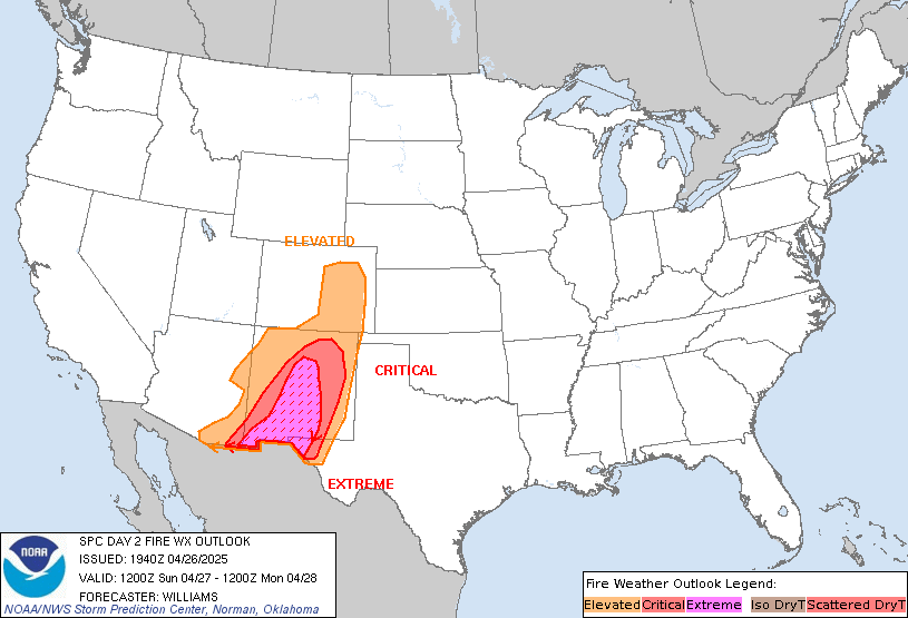
SPC Day 2 Fire Weather OutlookSPC Day 2 Fire Weather Outlook 
Day 2 Fire Weather Outlook
NWS Storm Prediction Center Norman OK
0152 AM CST Fri Feb 23 2024

Valid 241200Z - 251200Z

...NO CRITICAL AREAS...

...Synopsis...
An upper-level ridge will build in across the western US with
downstream troughing across the east D2/Saturday through the
remainder of the weekend. Surface high pressure over the Plains will
slowly weaken allowing for increasing winds through the day.
Southerly dry return flow will increase across the southern High
Plains and breezy northwest flow is expected in the lee of the
Rockies and central High Plains. While breezy, poor overlap of gusty
winds, low humidity and dry fuels is expected. As such, fire weather
concerns will remain low for much of the CONUS. Locally dry and
breezy conditions are possible across parts of the northern/central
Plains and central TX. However, fuels across these regions are less
receptive to fire spread suggesting fire-weather concerns will
remain localized.

..Lyons.. 02/23/2024

...Please see www.spc.noaa.gov/fire for graphic product...
Read morehttps://www.spc.noaa.gov/products/fire_wx/fwdy2.html
|
|


CMS The Best Conveyancing solicitors conveyancing quotes throughout the UK
For any webhosting enquiries please email webmaster@aus-city.com
|
|
Forums60
Topics765,615
Posts800,367
Members2,958
| |
Most Online17,963
Jan 15th, 2026
|
|
|
|
|
Copyright 1996 - 2026 by David Cottle. Designed by David Bate Jr. All Rights Reserved.
By using this forum, the user agrees not to transfer any data or technical information received under the agreement, to any other entity without the express approval of the AUS-CITY Forum Admins and/or authors of individual posts (Forum Admins and DoD/USSPACECOM for the analysis of satellite tracking data).
Two-line elements (TLE) and all other satellite data presented and distributed via this forum and e-mail lists of AUS-CITY are distributed with permission from DoD/USSTRATCOM.


Reprise Hosting


|

|